How accurate do you think your GPS position is?

The friendliest place on the web for anyone who enjoys boating.
If you have answers, please help by responding to the unanswered posts.

O C Diver

Guru
Joined
Dec 16, 2010
Messages
13,307
Location
Fort Myers, Florida
Vessel Name
End Of The Line
Vessel Make
Trinka 10 Dinghy
So I'm anchored for the next day and a half waiting out a storm in the Great Lakes. I'm anchored in a very protected cove (more like a lake that's 2/10 of a mile in diameter). The water is 9' deep with a fair amount of weed on the bottom. Anchor was thoroughly buried from 25 knot gusts from the South this morning. Front came through, and the gusts are now out of the North.

So the boat swings in an arc and drags through the weeds. The anchor likely pivoted or maybe popped out and reset.

Problem is that the MFDs tell you to the foot (maybe less) how far you are from your MOB anchor mark. I have no worries about my anchor, rode, scope, and can drag a couple hundred feet without issue. What I'm interested in knowing is when the display tells me I'm 112' from my anchor drop, how accurate is the mark from yesterday's drop of the hook and this afternoon's position. Yes, I understand that my GPS antenna is 15' from the bow roller which makes it a 30' error in this situation.

So what do you think the accuracy (same GPS numbers for the same position, repeatability) of your unit is, 24 hours apart? Don't tell me what your owner's manual says, tell me based on your experience.

Ted
 
Repeatability is often less than 10 feet.

You will always get some screwball readings but averages should be less than 3M/10 feet. Rarely do outside interferences interfere with all readings and all day or week.

Even my cheap handhelds would bring me to my parking spot every day year after year. Same with my anchoring up and down the ACIW.... the star of reading will be out hundreds of feet sometimes, but the dark cluster of readings always centers around about a 10 foot radius depending on how much the boat is swinging.

Local interference can occur...but where you are Ted, not likely.
 
Last edited:
Repeatability is often less than 10 feet.

You will always get some screwball readings but averages should be less than 3M/10 feet. Rarely do outside interferences interfere with all readings and all day or week.

Even my cheap handhelds would bring me to my parking spot every day year after year. Same with my anchoring up and down the ACIW.... the star of reading will be out hundreds of feet sometimes, but the dark cluster of readings always centers around about a 10 foot radius depending on how much the boat is swinging.

Local interference can occur...but where you are Ted, not likely.

So if your boat was blocked in the boatyard with the plotter running for a week, you would expect the accurate positions to be within a 10' radius of the GPS antenna?

Ted
 
What I'm interested in knowing is when the display tells me I'm 112' from my anchor drop, how accurate is the mark from yesterday's drop of the hook and this afternoon's position. Yes, I understand that my GPS antenna is 15' from the bow roller which makes it a 30' error in this situation.

Can't you ignore the 15' from the bow roller to the GPS antenna? When you dropped the anchor, if you didn't move, it would show a 0' difference because it is comparing how far the antenna moved relative to its position when the anchor was dropped.
 
I think the accuracy over time is quite repeatable these days, if differentially corrected. Before differential correction, there were sources of error that might drift over time with the weather, clock drift, etc. But this is all corrected out real time now by the differential correction scheme. It is what allows a 787 to land itself day after day and week after week.

Just leave your GPS tracking on in the berth and see what the scatter is for a week.
 
So if your boat was blocked in the boatyard with the plotter running for a week, you would expect the accurate positions to be within a 10' radius of the GPS antenna?

Ted

Yes, but there would be a loose star of erroneous positions around a dense cluster of accurate readings.

I have seen it many tines when in a slip and left the chartplotter on.
 
Interesting question.

And an interesting byproduct question I'm looking at is GPS position vs marker locations on the MFD chart.

With a new boat, new electronics, and having run the GPS calibration, I'm looking at just how accurate the positioning is.

The other day I was running up the narrow marked channel to my marina and at one point it had me located on the MFD outside the markers on the chart. Not by a lot. But enough to pause and consider night operations in another "light".

Simrad, running Navionics.

Any error can be either GPS error or it can be the markers not located exactly correct on the chart.
 
Can't you ignore the 15' from the bow roller to the GPS antenna? When you dropped the anchor, if you didn't move, it would show a 0' difference because it is comparing how far the antenna moved relative to its position when the anchor was dropped.

While I could make the mark before dropping the hook (and drifting back to the antenna's position), the error when I swing 180 degrees will still be there. There is also some small distance from the drop point to the set point.

Ted
 
I think the accuracy over time is quite repeatable these days, if differentially corrected. Before differential correction, there were sources of error that might drift over time with the weather, clock drift, etc. But this is all corrected out real time now by the differential correction scheme. It is what allows a 787 to land itself day after day and week after week.

Just leave your GPS tracking on in the berth and see what the scatter is for a week.

I guessing the 787's GPS is of a higher quality ans accuracy than my MFD, which is more accurate than my tablet.

Ted
 
Yes, but there would be a loose star of erroneous positions around a dense cluster of accurate readings.

I have seen it many tines when in a slip and left the chartplotter on.

Ok, so ignoring the erroneous positions, the cluster has a 20' diameter? So in a worse case scenario, you could be between two positions marked 20' apart?

Ted
 
I would say so in my experience.... I have had great accuracy over the last 20 years with the occasional glitch.
 
So where part of this question comes from is being 112' from the anchor drop with a 20 knot gust. 20 minutes later, on the same line to the anchor drop with the same 20 knot gusts, but I'm 93' away. Keep in mind the water depth is 9'.

Ted
 
A year or two ago there were articles, linked by Boat US, about how the govt was doing something that degraded GPS accuracy. From memory, from something like 6-8 ft to something like 20 ft.
 
I guessing the 787's GPS is of a higher quality ans accuracy than my MFD, which is more accurate than my tablet.

Ted
Actually I dont think it is.

There are no specific alterations that I know of to GPS since selective availability was shut off decades ago. Unless antenna improvement or some sort of shielding is somehow improved in the aircraft, the accuracy shold be similar.

As I posted before, my 1990s handheld could guide me into a parking spot day aftsr day. Google mapes would show my position in a slip marina after marina.

One has to be careful of phone and tablet GPS if it uses cel triangulation, that I have seen much larger errors in.
 
So how do you know when you are on one of those 5/100 momentary excursions? Your other navigation means.
 
Can never be 100 percent sure, but a lot of articles are saying selective availability is not being used recently

So accuracy isn't being degraded.

My phone has me pinpointed within a couple feet in an RV spot in Georgia. A few minutes kater it had me in the exact same spot.

Estimating GPS accuracy based on chain stretch is never gonna be an exact science.
 
Last edited:
Interesting topic.
So I logged into my boat monitor system that has GPS and tracking. A satelite view shows the boat, berth and waypoints (I think at 15 minute interval) as the gps signal moves around my secured boat gps antenna. The estimated distance I can see is within the 10 feet suggested so far. I have a large geo fence around hte boat and a low number of tracking points on purpose as I used to get alerts the boat has left the dock when there were some large distance movements in excess of 20 feet of the gps. As I watch the boat is plotted sitting on the dock.
 
My Furuno SCX 20 Satellite antenna/compass is good to a couple feet according to the sales information. Whenever I turn it on at the dock, it shows me exactly my perfect position and facing direction. It has 4 antennas inside. I have never dropped an MOB marker to see if there was a change. I think next time I anchor I'll try to mark my drop spot and keep an eye on it. Good idea. The GPS on my iPhone running Navionics showed me about 75 feet from my actual location when I returned to my dock from a trip with a friend whose nav gear was not functioning. It would have me jumping around but the short time I watched it, it never found me. I remember using Loran C and if I memorized a location it would bring me back to within 3 feet. I know because I tested it at a harbor buoy a few times.

My old 2000+ Raymarine unit would show me jumping all over the chart at the dock. Out in the water, on land, back to the water, until I was underway, then it tightened up nicely.
 
A year or two ago there were articles, linked by Boat US, about how the govt was doing something that degraded GPS accuracy. From memory, from something like 6-8 ft to something like 20 ft.


The thing you are thinking about is called "selective availability" and it is a degrading circuitry available to the DOD which they have been directed to disable by Presidential Order (May 2000). The current generation of satellites have been constructed without this function.


To speak to the original question, if his GPS is "WAAS enabled", (Wide Area Augmentation System; your hypothetical 787 has this :socool: ), it will have 3 meter accuracy. Check your owner's manual.
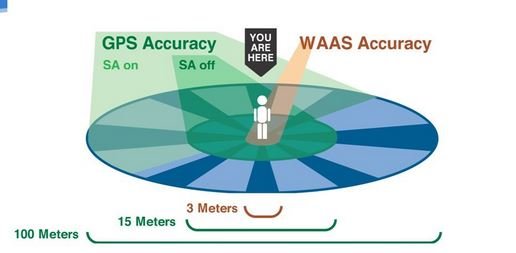
 

Attachments

  • waas.JPG
    waas.JPG
    22.8 KB · Views: 84
Last edited:
Can never be 100 percent sure, but a lot of articles are saying selective availability is not being used recently

So accuracy isn't being degraded.

My phone has me pinpointed within a couple feet in an RV spot in Georgia. A few minutes kater it had me in the exact same spot.

Estimating GPS accuracy based on chain stretch is never gonna be an exact science.

I think that was during Operation Desert Storm.
 
While I could make the mark before dropping the hook (and drifting back to the antenna's position), the error when I swing 180 degrees will still be there. There is also some small distance from the drop point to the set point.

Ted

I know 20 knts is a good blow but maybe the chain is circling the anchor and not pulling tight becoming a circle or arc on the bottom.
 
I once left my tracking on for months while the boat was tied to the dock. 99% of the time the mark was in a 6’ diameter. 1% of the time there was a mark somewhere between 10’ and 300’. There was one mark that was 1/4 mile off.
 
I once left my tracking on for months while the boat was tied to the dock. 99% of the time the mark was in a 6’ diameter. 1% of the time there was a mark somewhere between 10’ and 300’. There was one mark that was 1/4 mile off.

:thumb:
I have had similar results.
 
Mine doesn't move in any detectable way, but it's a pretty good sat compass with I think 3 GPS receivers that triangulate. I also have a mushroom GPS that does move around a bit. Much depends on the GPS and it's capabilities, the number of satellites in view, and the spread of those satellites across the sky. Plus of course which of the various correction methods it supports with WAAS, DGPS, SBAS, etc.


As one counter example, if I use Gaia GPS on my phone, my position moves around about 10'.


And as another counter example, I have a sub-meter GPS for rough surveying that is good to within about a foot, but you have to put it in place and leave it for a while. Over time it figures out the position to within a foot, assuming a good GPS signal.
 
The thing you are thinking about is called "selective availability" and it is a degrading circuitry available to the DOD which they have been directed to disable by Presidential Order (May 2000). The current generation of satellites have been constructed without this function.


To speak to the original question, if his GPS is "WAAS enabled", (Wide Area Augmentation System; your hypothetical 787 has this :socool: ), it will have 3 meter accuracy. Check your owner's manual.

I think this was the article he was referring to:

https://www.boatus.com/expert-advice/expert-advice-archive/2021/february/dont-mess-with-gps

Ted
 
Mine doesn't move in any detectable way, but it's a pretty good sat compass with I think 3 GPS receivers that triangulate. I also have a mushroom GPS that does move around a bit. Much depends on the GPS and it's capabilities, the number of satellites in view, and the spread of those satellites across the sky. Plus of course which of the various correction methods it supports with WAAS, DGPS, SBAS, etc.


As one counter example, if I use Gaia GPS on my phone, my position moves around about 10'.


And as another counter example, I have a sub-meter GPS for rough surveying that is good to within about a foot, but you have to put it in place and leave it for a while. Over time it figures out the position to within a foot, assuming a good GPS signal.

So if the 3 GPS satellite compass is a more accurate position, how does it figure out your most likely position? Is it based on voting logic where it averages the closest 2 out of 3?

Ted
 
Interesting question.

And an interesting byproduct question I'm looking at is GPS position vs marker locations on the MFD chart.

With a new boat, new electronics, and having run the GPS calibration, I'm looking at just how accurate the positioning is.

The other day I was running up the narrow marked channel to my marina and at one point it had me located on the MFD outside the markers on the chart. Not by a lot. But enough to pause and consider night operations in another "light".

Simrad, running Navionics.

Any error can be either GPS error or it can be the markers not located exactly correct on the chart.

I have several turns coming into my home, and the navaids vary in their positional accuracy in reference to the chart. Radar overlay with shadow track on (to confirm non-moving contact) confirms this and is my preferred method of night navigation. If you don't have that feature, going very slowly and confirming every marker with a spotlight after a general cue from the chartplotter is a safe way to proceed.

Regarding low viz conditions (fog/rain/smoke) GPS without radar versus navaids and other vessels is a game I would not play - pull over and anchor.
 
So if the 3 GPS satellite compass is a more accurate position, how does it figure out your most likely position? Is it based on voting logic where it averages the closest 2 out of 3?


Ted
Reminds me of the old saying. " A man with a clock always knows what time it is. A man with two clocks is never sure."

Peter
 
Last edited:
For those unfamiliar.... the GPS is accurate, it often is the charting on the plotter that is "off".

GPS once verified with breadcrumb trails or other techniques for a safe passage...you can pretty much bet your life on it if you use backups to verify. Sure radar and sounders help verify and having all and being proficient with all is great, but for the novice...and many do it regularly, shooting tricky waterways on GPS alone has changed amateur boating forever.

There are a list of things that can degrade GPS accuracy and WAAS helps correct but ultimately still has some inaccuracies.
 
Last edited:
Back
Top Bottom