O C Diver
Guru
- Joined
- Dec 16, 2010
- Messages
- 12,927
- Location
- USA
- Vessel Name
- Slow Hand
- Vessel Make
- Cherubini Independence 45
So I'm anchored for the next day and a half waiting out a storm in the Great Lakes. I'm anchored in a very protected cove (more like a lake that's 2/10 of a mile in diameter). The water is 9' deep with a fair amount of weed on the bottom. Anchor was thoroughly buried from 25 knot gusts from the South this morning. Front came through, and the gusts are now out of the North.
So the boat swings in an arc and drags through the weeds. The anchor likely pivoted or maybe popped out and reset.
Problem is that the MFDs tell you to the foot (maybe less) how far you are from your MOB anchor mark. I have no worries about my anchor, rode, scope, and can drag a couple hundred feet without issue. What I'm interested in knowing is when the display tells me I'm 112' from my anchor drop, how accurate is the mark from yesterday's drop of the hook and this afternoon's position. Yes, I understand that my GPS antenna is 15' from the bow roller which makes it a 30' error in this situation.
So what do you think the accuracy (same GPS numbers for the same position, repeatability) of your unit is, 24 hours apart? Don't tell me what your owner's manual says, tell me based on your experience.
Ted
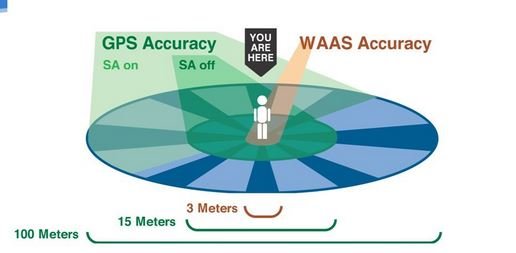
 ), it will have 3 meter accuracy. Check your owner's manual.