A warning using C-map with TZ

The friendliest place on the web for anyone who enjoys boating.
If you have answers, please help by responding to the unanswered posts.
Navionics: bottom left corner click to select SonarChart


Ah. OK, now I can see Navionics contour lines.

And they're different from the C-Map contour lines.

Hmmm....

But I don't think either shows me anything more useful (for Fairlee Creek) than the NOAA chart.

It's just a place where I'd want to have local knowledge in advance. And the first time, maybe follow someone else in, too. (Although our first time in was just using local instructions, not following someone in... and we didn't ground so it must have been right.)

I think Peter's comments about data control apply: transducer offset? time relative to tide (actual or predicted)? et cetera...

-Chris
 
Last edited:
Ah. OK, now I can see Navionics contour lines.

And they're different from the C-Map contour lines.

Hmmm....


-Chris

And now you see what I have been questioning about accuracy.

More ACCURATE detail is helpful. Inaccurate detail can get you into trouble. No detail? Well at least you know you are blind even though being blind is hardly a good thing.
 
And now you see what I have been questioning about accuracy.

More ACCURATE detail is helpful. Inaccurate detail can get you into trouble. No detail? Well at least you know you are blind even though being blind is hardly a good thing.


Yep, I understand more about what you're seeing now. But I think Peter's got it right: more stuff on the screen doesn't make it accurate, useful, etc.

Consider how many survey boats you see out there being run by Garmin, Navionics, Furuno, -Map, etc... (I'd guess none.)

Consider all the potential technical issues associated with normalizing crows sourced data. (Many.)

Using Fairlee Creek as an example again, what do the Navionics and C-Map contour lines -- which also differ from each other -- add to your knowledge about how to get in and out of there? (For me, not much, if anything.)

I guess I don't see all that much useful difference in charts from the big 4... at least for out typical area. I've read Navionics sucks in the Bahamas, C-Map charts for the Bahamas include the Explorer charts which are very useful, one brand or other (forget which) isn't great off the Australian coast, etc... but for our run-of-the-mill general purposes, they all seem decent enough.

(Except annual NOAA updates are free and Garmin charges $99 for what looks to be essentially the same updates.)

-Chris
 
Just for clarification garmin does not give a free update. I found this out last month.

If they don't that's something new. My experience is that if you buy the chart, say from Defender. You are initialed to one free upgrade. Same goes try in buying one of there MDFs.

Keep in mind that in buying the chart over the counter or in a MFD you don't now how old the chart is.
 
Charts. Seems no one has ALL of the charts options.

On my Raymarine Axioms, I can display NOAA and CHS raster and vector, Raychart vector, Navionics, C-Map, and a few others. Even all at the same time (I think) though I only routinely do 2 at a time.
 
If they don't that's something new. My experience is that if you buy the chart, say from Defender. You are initialed to one free upgrade. Same goes try in buying one of there MDFs.

Keep in mind that in buying the chart over the counter or in a MFD you don't now how old the chart is.


Thats how i thought it was when i bought the vision g3 chart for $350.00.less then a year a new update showed up but if i wanted it i had to buy it. There new policy is they only guaranty the chart based on the purchase date. If you buy a mfd and they come out with a new chart after it will cost you. If the mfd had an old chart loaded at the time you register the unit you can update the unit to the chart version based on the date you purchased the unit.
 
On my Raymarine Axioms, I can display NOAA and CHS raster and vector, Raychart vector, Navionics, C-Map, and a few others. Even all at the same time (I think) though I only routinely do 2 at a time.

Good to know. Thanks for that.
 
If they don't that's something new. My experience is that if you buy the chart, say from Defender. You are initialed to one free upgrade. Same goes try in buying one of there MDFs.

Keep in mind that in buying the chart over the counter or in a MFD you don't now how old the chart is.

Thats how i thought it was when i bought the vision g3 chart for $350.00.less then a year a new update showed up but if i wanted it i had to buy it. There new policy is they only guaranty the chart based on the purchase date. If you buy a mfd and they come out with a new chart after it will cost you. If the mfd had an old chart loaded at the time you register the unit you can update the unit to the chart version based on the date you purchased the unit.


This boat came with a Garmin 7612xsv, installed probably circa 2016-ish. New versions of both software and charts were available when we got to the boat in June. Software update free. Chart update, $100.

Now there's a newer chart update available. $100.

-Chris
 
This boat came with a Garmin 7612xsv, installed probably circa 2016-ish. New versions of both software and charts were available when we got to the boat in June. Software update free. Chart update, $100.

Now there's a newer chart update available. $100.

-Chris

Sounds right? But has their policy changed? The chart update was more than 50% off than? When you say software, do you mean firmware. Firmware is always free, its the dam charts that cost us $$$.

Garmin as C-Map has always been 50% off on updates. But no more Garmin for me!:thumb:
 
Sounds right? But has their policy changed? The chart update was more than 50% off than? When you say software, do you mean firmware. Firmware is always free, its the dam charts that cost us $$$.

Garmin as C-Map has always been 50% off on updates. But no more Garmin for me!:thumb:


I dunno about their policies; we're recent inheritors of the system, so dunno what it was like before.

I said software because it wasn't (I think) BIOS. The process seemed more like updating the operating system. And it wasn't charts, anyway. I think our current system is v20.40 (and I can't find my notes on what the earlier version was).

Our chart update was from G2 to G3 "built-ins". Currently installed is v2021.50.v23.00 (ditto notes on previous version number). My Garmin Express account says there's a G3 update available, but I haven't begun to pay attention to that yet.

-Chris
 
Chris:

Since I'm not an owner of it, I am researching online and talking to dealers at shows. Set me straight if I don't have this right.

Furuno has 3 layers to the package. Hardware is Furuno. Then you have to buy / subscribe to TZ. Then you get charts. Any other option is 2 layers. I just don't get it on an expensive electronics package where you have to subscribe to 3rd party software to use the electronics.

Seems like there might be some confusion about this. You don't need to subscribe to or buy TimeZero on a PC in order to use Furuno TZTouch2/3 MFDs. If you choose to use TimeZero on a PC in addition to TZTouch2/3 MFDs, you only have to buy the charts once and they work on both PC and MFD.

Furuno gives you more flexibility than anyone else. Don't want an MFD at all? That's fine, use TimeZero on a PC with Furuno radar and sounder sensors/modules. Don't want a PC? Use a TZTouch MFD. Want both? That works too. Simrad, Garmin, and Raymarine have no equivalent to TimeZero on the PC, they just have MFDs or black box MFDs.

Help me out here. I've been through the TZ promotional video. I'm not seeing it do anything not already resident on pretty much all MFD devices, without the need for this extra layer of stuff. Not seeing what it adds. I'd be all ears if you have a compelling reason to share for why it exists.
 
Help me out here. I've been through the TZ promotional video. I'm not seeing it do anything not already resident on pretty much all MFD devices, without the need for this extra layer of stuff. Not seeing what it adds. I'd be all ears if you have a compelling reason to share for why it exists.


I’m not sure what extra layer of stuff you are thinking of. Comparing MFD to MFD, you buy the MFD, and you load charts or your choice. That’s true of all vendors.

With Garmin, your only choice for charts are Garmin charts.

With Simrad I think they still offer basic charts included with the MFD, and you can purchase c-map charts. Maybe Navionics too, but I’m not certain.

With Furuno, all the NOAA charts are free, including all updates. Additionally you can purchase C-map charts. You can also load a wide range of other official charts from around the world.

So they all seem equivalent, though slightly different in the details.
 
Help me out here. I've been through the TZ promotional video. I'm not seeing it do anything not already resident on pretty much all MFD devices, without the need for this extra layer of stuff. Not seeing what it adds. I'd be all ears if you have a compelling reason to share for why it exists.

I think it's largely personal preference.

I have a 15" TZT2 MFD sitting next to a PC running TZ Pro. They talk to each other seamlessly and share all sensors. I do all my route plotting on the PC because I find it easier, faster, and more intuitive. I like having a big, high-res 27" display, physical keyboard, and trackball/mouse instead of a touch screen. It can be quite a bit cheaper, too, particularly if you're willing and able to use displays and PCs that aren't waterproof and marine-specific. If you go with a rugged PC and waterproof, daylight viewable display the cost savings evaporate, but you still have more flexibility in screen size and input devices.
 
Thanks. I'm trying to avoid extraneous additional devices. My 38 footer doesn't have the expansive helm station of a Nordhavn 50, and would not be dragging a PC up to the flybridge for basic functionality when operating from there.
 
Summary of the Navionics offering for Simrad. Describes some of the value added features for Navionics such as auto-routing which is handy for initial planning of time and distance.

https://www.navionics.com/usa/company/supported-manufacturers/navico-lowrance-simrad-b-and-g

Since the dawn of MFDs, people have planned routes on a PC and downloaded to their MFD. Someone may have better information, but for Navionics, I believe the interface is a free user account on the Navionics website. It's slightly clunky and requires an internet connection of course. And you would need some way to upload to the MFD so an onboard network of some sorts.

My point being that the base navigation planning functions are fine, but may people find the enhancements such as including a PC in the overall environment make life a bit easier.

I personally like the Navionics interface. Suits me well to have Simrad MFD. But I could work with anything. Of the larger systems, there are more similarities than differences.

Peter
 
Peter:

That's where I was headed as my default choice. But now Simrad no longer has Navionics. And as a consequence of that, there isn't any auto-route function either, which ran inside of Navionics. Their website no longer mentions auto-route functions so it appears it can't be done inside of Cmap. Auto route isn't a "must have", but a handy option.

And yeah, one can access Navionics for free on the website. Having shut down access outside of Garmin world one has to wonder how long that stays open.

Simrad also just replaced the operating system for their lower end MFD's. I have to believe that migrates upward. When? The new operating system has no material information out other than "It's Great!" one minute promo clips. Might that address some needs? No way to know.
 
Help me out here. I've been through the TZ promotional video. I'm not seeing it do anything not already resident on pretty much all MFD devices, without the need for this extra layer of stuff. Not seeing what it adds. I'd be all ears if you have a compelling reason to share for why it exists.

Seems like there might be some confusion about this. You don't need to subscribe to or buy TimeZero on a PC in order to use Furuno TZTouch2/3 MFDs. If you choose to use TimeZero on a PC in addition to TZTouch2/3 MFDs, you only have to buy the charts once and they work on both PC and MFD.

Thanks. I'm trying to avoid extraneous additional devices. My 38 footer doesn't have the expansive helm station of a Nordhavn 50, and would not be dragging a PC up to the flybridge for basic functionality when operating from there.


What he said. No need to buy/use TZ at all, if you don't want to.

We chose to, as an additional back-up/complement to the NavNET 3D MFD we installed back on the previous boat... and that plan continues when we get a new TZT3 MFD installed on this boat.

But TZ is completely optional. We keep it running on the ship's laptop in the cabin while underway, partly to record our track (redundant recording), partly as a hot spare should the MFD on the bridge crap out... but that never happened. (And we also run something like Aqua Map on a tablet on the bridge, as I mentioned before, partly for mobility and guest info.)

More often, we use TZ for research and planning, and some of that happens on the home system too since 2 licenses came with our version of TZ. And I can use a full range of PC tools on charts when I feel like it (snip and then print/file/email map portions, compare with Google Earth, etc.).

-Chris
 
Last edited:
Peter:

That's where I was headed as my default choice. But now Simrad no longer has Navionics. And as a consequence of that, there isn't any auto-route function either, which ran inside of Navionics.

Is this true, that Navico products (Simrad, Lowrance, B&G) are no longer running Navionics? If so, what replaced it? I haven't been in the water yet so my info is dated.

I confess, I've never used auto-route on an MFD, only my tablet/phone. But I also prefer route planning on a PC with tweaks on MFD (if necessary). Just faster and more comfortable.

Peter

EDIT - Feb 21 2022 article comparing Navionics with C-MAP. States Navionics is compatible with Navico/Simrad. Thoughts?

https://tacklevillage.com/navionics-vs-c-map/
 
Last edited:
Peter:

That article came out just as or just before Navionics no longer became available outside of Garmin world. Having said that, there is one lower end Furuno series that apparently can still run Navionics.

Go to the Simrad site and look at the map choices. Its now limited to Cmap, and vector / rastor charts.

I did just check out the page for the new lower end Simrad MFD, and it brags about fast auto route inside of Cmap, so maybe that's coming into higher end products too.

Cmap is working on something called Genesis Social. It is bathy data collected by users and uploaded and shared. That can only be as good as the quantity of users doing it. And the quality of the data. I question the data quality in a major way when I look at spots like Kent Narrows and it shows 1 ft of water in a channel used by boats of significant size, and that carries into a marina with boats drawing no less than 4-5 ft. As I said before, the only thing worse than no data is bad data.

You can see the Genesis charts here:

http://https://www.genesismaps.com/SocialMap
 
Last edited:
I only remember seeing that Navionics became unavailable for the Time zero based Furuno gear. I don't think they discontinued the cards for other systems.
 
I only remember seeing that Navionics became unavailable for the Time zero based Furuno gear. I don't think they discontinued the cards for other systems.

It seems to have to do the operating systems.
 
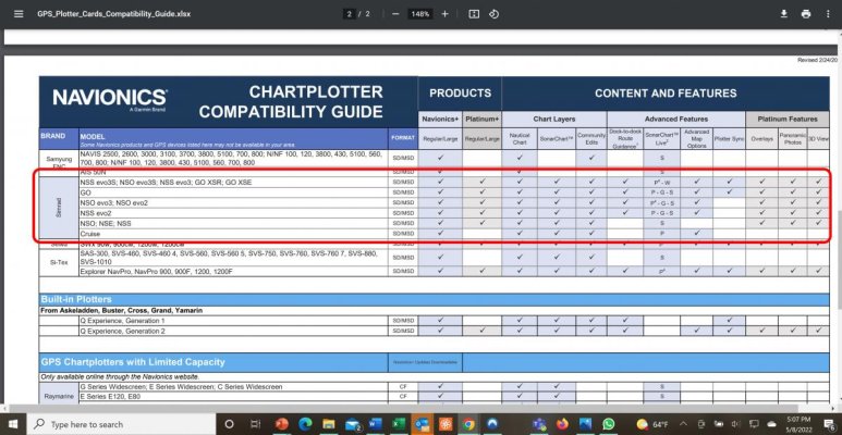
Well, this is from the Navionics website - appears they are compatible with Simrad (Lowrance and B&G are on the previous page so not on the screenshot below).

https://www.navionics.com/media/wys...des/GPS_Plotter_Cards_Compatibility_Guide.pdf

Appears Simrad may be discontinuing the NSS-3 series. According to the attached, these are fully integrated into the Navionics interface. Newer series have somewhat limited interface.

When Garmin purchased Navionics, I always wondered why other platforms were supported. Strange industry - jealous and permiscuous at the same time.

Peter
Navionics Simrad Compatibility.jpg
 
When Garmin purchased Navionics, I always wondered why other platforms were supported. Strange industry - jealous and permiscuous at the same time.

I expect they've probably run the numbers. If they dropped support for others, some might switch to Garmin to keep the charts, but others would just use other charts instead. All a question of whether they'd lose more than they'd gain.
 
Peter:

Top right corner of your screen shot. Updated in 2020. But obviously a contrary piece of info. If I already owned Simrad I'd be calling them to find out what the straight scoop is before buying a fresh card. If you do find out I'd be interested in what you find.
 
Peter,

What is an ATON?
 
I don't believe any chart company actually takes depth measurements themselves. They take government chart data and display the data in some convenient form. Only wealthy countries, i.e. the USA and Western Europe, could afford to have survey ships recording accurate depths. So naturally charts (other than in commercial harbors) in Mexico and similar places will not be accurate. As they say, lipstick on a pig ....

Cruisers in Mexico use inavx with the blue latitude charts made by Sean and Heather. They made accurate measurements of most popular anchorages. The old government charts, which are sometime over a mile off, will get you close enough to the anchorage so that you can then switch to the Blue Latitude charts.

I suspect that all those sexy depth contour lines that Navionics shows are just the imagination of some software program that makes an educated guess. Don't ever rely on them. That is the reason that Navionics shades the area near shore. They don't want to get sued when you run aground.

Bottom line (no pun intended) is that there is probably no better data than what the noaa raster charts displays.
 
Back
Top Bottom