Alaskan Sea-Duction
Guru
- Joined
- Jul 6, 2012
- Messages
- 8,062
- Location
- USA
- Vessel Name
- Alaskan Sea-Duction
- Vessel Make
- 1988 M/Y Camargue YachtFisher
This is going to be fun. Extra lines on the boat.
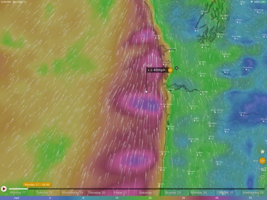
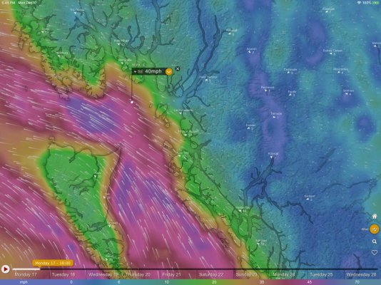
.GALE WARNING TODAY...
...STORM WARNING LATE THIS AFTERNOON THROUGH TONIGHT...
Synopsis: A broad area of low pres will remain over the Gulf of Alaska. A series of strong fronts will move across the waters this week. The next front will push into the region tonight, then inland early Tue. Another front will arrive later Wed night into Thu.
Today
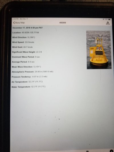
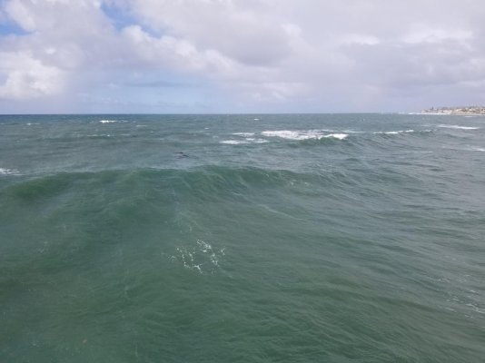
S wind 15 to 25 kt this am, then winds increasing to 25 to 35 kt. Later this afternoon, S wind becoming 30 to 35 kt, with gusts to 50 kt. Combined seas 22 to 25 ft with dominant period of 19 seconds. Scattered showers. Rain later today.
Tonight
S wind 35 to 45 kt, with gusts to 55 kt, becoming SW 25 to 35 kt after midnight. Combined seas 25 to 30 ft with a dominant period of 16 seconds, subsiding to 25 ft after midnight. Rain.
Tue
SW wind 25 to 30 kt. Gusts to 45 kt early. Combined seas 23 to 27 ft with a dominant period of 14 seconds in the morning, then subsiding to around 20 ft. Rain in the morning, then showers likely.
Tue Night
SW wind 20 to 25 kt. Wind waves SW 6 ft at 8 seconds. W swell 20 ft at 13 seconds. Chance of showers.
Wed
SW wind 10 kt, becoming SE 20 to 25 kt in the afternoon. Wind waves SW 3 ft at 4 seconds. W swell 22 ft at 14 seconds. rain likely.
ThuS wind 35 to 40 kt in the morning, then SW 20 to 25 kt. combined seas 20 to 25 ft.
Fri
SE wind 10 to 15 kt. Wind waves 3 ft. NW swell 15 ft.
.GALE WARNING TODAY...
...STORM WARNING LATE THIS AFTERNOON THROUGH TONIGHT...
Synopsis: A broad area of low pres will remain over the Gulf of Alaska. A series of strong fronts will move across the waters this week. The next front will push into the region tonight, then inland early Tue. Another front will arrive later Wed night into Thu.
Today
S wind 15 to 25 kt this am, then winds increasing to 25 to 35 kt. Later this afternoon, S wind becoming 30 to 35 kt, with gusts to 50 kt. Combined seas 22 to 25 ft with dominant period of 19 seconds. Scattered showers. Rain later today.
Tonight
S wind 35 to 45 kt, with gusts to 55 kt, becoming SW 25 to 35 kt after midnight. Combined seas 25 to 30 ft with a dominant period of 16 seconds, subsiding to 25 ft after midnight. Rain.
Tue
SW wind 25 to 30 kt. Gusts to 45 kt early. Combined seas 23 to 27 ft with a dominant period of 14 seconds in the morning, then subsiding to around 20 ft. Rain in the morning, then showers likely.
Tue Night
SW wind 20 to 25 kt. Wind waves SW 6 ft at 8 seconds. W swell 20 ft at 13 seconds. Chance of showers.
Wed
SW wind 10 kt, becoming SE 20 to 25 kt in the afternoon. Wind waves SW 3 ft at 4 seconds. W swell 22 ft at 14 seconds. rain likely.
ThuS wind 35 to 40 kt in the morning, then SW 20 to 25 kt. combined seas 20 to 25 ft.
Fri
SE wind 10 to 15 kt. Wind waves 3 ft. NW swell 15 ft.