Dorian aims for East Coast of Florida

The friendliest place on the web for anyone who enjoys boating.
If you have answers, please help by responding to the unanswered posts.
My problem is taking enough fuel to return. It may be best to transfer funds to someone you know.

Other Islands will have fuel like Great Harbour Cay or Bimini or Cats Cay
 
Bahamas Press has photo of bodies being loaded onto a flat bed truck and a short report on casualties. Not posting here. Available if you want to go look.
 
And, it's going to be a long time before their world even begins to resemble the one they lost. Years. But, most of the media will have completely forgotten about the Abacos is a week or two. I know that from experience, too.

I hate it for them and what they are going to be going through. You're never the same.

Unfortunately what is likely to happen, before Dorian has been down graded to a TS, Abaco may be mentioned in passing. It is a sparsely populated island that is not part of the US. Besides a small segment of boaters and vacationers, Abaco isn't even a place most US citizens could identify on a map. The news cycle will want the drama of the destroyed infrastructure ONLY IF there is no significant damage to US property.

The road to recovery will be measured in years not months.
 
Bahamas Press has photo of bodies being loaded onto a flat bed truck and a short report on casualties. Not posting here. Available if you want to go look.

So sad. Prayers for all.....
 
USCG got into Marsh Harbour today by helicopter, evacuated 19 and took a doctor and medics there.

Just heard an interview with a man who stayed on Marsh Harbour. Clearly going to be a lot more than the five deaths reported.
 
Unfortunately what is likely to happen, before Dorian has been down graded to a TS, Abaco may be mentioned in passing. It is a sparsely populated island that is not part of the US. Besides a small segment of boaters and vacationers, Abaco isn't even a place most US citizens could identify on a map. The news cycle will want the drama of the destroyed infrastructure ONLY IF there is no significant damage to US property.

The road to recovery will be measured in years not months.

I'm afraid you're right. Outside of those of us in South Florida and a few other boaters, there won't be a lot of thought. They're people we know, we've all met, who have treated us with friendship and enriched our lives.
 
Five o'clock update says Movement is now stationary - right over West End. It's going to be a nightmare for Old Bahama Bay and that area.

Additionally, Michael Pintard (minister of agriculture) and his video from his house in Grand Bahama. How bad? After I showed it to my wife she asked me to please not show her any more.


Menzies, thank you for the video links. Finally, some real reports from Grand Bahama, as horrifying as they are. (I can't get the Weather Channel on our Youtube TV up here in Knoxville.)


The Minister's video comments, "My house is 20 feet up, so this water is 20-25 feet high" in conjunction with his film of the ominous brown storm surge water lapping at his upper windows, should be required viewing for all island-dwellers and coastal dwellers in the future.

A 15-20 ft storm surge was predicted.

On Google Earth, zooming in closely on the upper Bahamas, you can see how much of the islands' land is just above sea level (the numeric - land height above sea level - is down at the bottom of the screen on Google Earth, and moves with your cursor placement). Most of the islands and cays' land is just a few feet above sea level, with a few inland spots higher.


Too many of the homes are one-story.


Green Turtle Cay doesn't have any high land at all. It is a barrier island. Some residents remained there before the hurricane storm surge hit.

I can't write the rest of what I am imagining after seeing those videos. God have mercy on our Bahamian neighbors.


Mrs. Trombley
 
Last edited:
Many things to be accomplished before meaningful aid arrives.
Clearing the roads so the aid can be distributed, rebuilding the the airport and harbor removing navigation hazards, locating warehouses in various places.... rebuilding the FW system and electrical distribution and sanitary systems, building supplies.
Until these projects are well underway, aid will be limited. For now, water and food (MREs) tents and sanitation.

OPINION:
Sadly, even if everything could be accomplished over night, people will complain, the US is not doing enough, the media will do everything possible to make the US look bad and that really p*sses me off.
 
9:00 update - still stationary (is that redundant?) just off the north coast of Grand Bahama. Looks like right over Mangrove Cay.

Here is the updated position. Help me out here. How can it be 26.8N. The minutes and seconds only go to 60?

LOCATION...26.8N 78.4W
ABOUT 25 MI...40 KM NE OF FREEPORT GRAND BAHAMA ISLAND
ABOUT 105 MI...170 KM E OF WEST PALM BEACH FLORIDA
MAXIMUM SUSTAINED WINDS...140 MPH...230 KM/H
PRESENT MOVEMENT...STATIONARY
MINIMUM CENTRAL PRESSURE...942 MB...27.82 INCHES
 
Last edited:
Hi menzies, I think you are talking about the latitude which is 26.8, not 76.8.
To answer your question they are talking degrees and tenths of a degree. They aren’t using minutes and seconds.

I’ve been watching the latitude closely and it was at 26.6 for many hours. Looks like it’s finally drifting north, very slowly.

Yes, fixed it. Question is still the same. Why would they use tenths of a degree rather than minutes?

Really strange.

That was my hope. By stalling, the western guiding front would have more time to collapse, so when the turn happened it would be more east.

We shall see. House battened down and small boat on dock wrapped like a Christmas present. Ready for the worst, hoping for the best.
 
Parks is correct. Some use minutes and seconds (the way I learned when Columbus was still navigating) today many prefer minutes and percentage. Both work.
 
Dependent upon the weather there is some local relief planned for this weekend. Look up Man-O-WAR , Bahamas info on FaceBook. They are saying that plans are to go to the Abacos from Spanish Wells and Nassau area.
They did say that any private boat owners in the area or considering making the trip later on from the mainland on their own that its quite possible that the water will have a lot of debris in it. So this may cause you harm if not careful. So they are recommending a pause for now unless you work with organizing groups. What a sad state of affairs for the local people in that area, Great bunch of local people...
 
10:00 update.

Still sitting right there.

LOCATION...26.8N 78.4W
ABOUT 25 MI...40 KM NE OF FREEPORT GRAND BAHAMA ISLAND
ABOUT 105 MI...170 KM E OF WEST PALM BEACH FLORIDA
MAXIMUM SUSTAINED WINDS...140 MPH...230 KM/H
PRESENT MOVEMENT...STATIONARY
MINIMUM CENTRAL PRESSURE...942 MB...27.82 INCHES
 
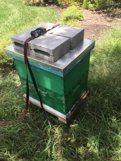
Just about a month ago I met a really nice guy from a Grand Bahama. He was a bee keeper. I’m sure he has lost all of his hives. Not much you can do to protect a box of stinging insects. I hope he’s ok.
 

Attachments

  • AD57D582-3555-4BD6-BF80-BB7672688B02.jpg
    AD57D582-3555-4BD6-BF80-BB7672688B02.jpg
    202.2 KB · Views: 56
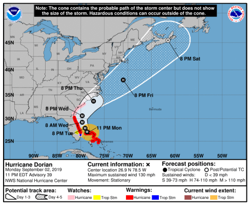
Still sitting right there at the 11:00 update. But winds have dropped to 130 from 145 earlier. No track update yet.

LOCATION...26.9N 78.5W
ABOUT 30 MI...55 KM NNE OF FREEPORT GRAND BAHAMA ISLAND
ABOUT 100 MI...160 KM E OF WEST PALM BEACH FLORIDA
MAXIMUM SUSTAINED WINDS...130 MPH...215 KM/H
PRESENT MOVEMENT...STATIONARY
MINIMUM CENTRAL PRESSURE...946 MB...27.94 INCHES

The good news for JAX is that the wind probabilities have dropped significantly - suggesting the track has moved east. Worst case is a 21% probability of 34 kt winds.

JACKSONVILLE 34 1 2( 3) 21(24) 21(45) 6(51) X(51) X(51)
JACKSONVILLE 50 X X( X) 3( 3) 7(10) 3(13) X(13) X(13)
JACKSONVILLE 64 X X( X) X( X) 2( 2) 1( 3) X( 3) X( 3)
 
Last edited:
Still sitting right there at the 11:00 update. But winds have dropped to 130 from 145 earlier. No track update yet.

LOCATION...26.9N 78.5W
ABOUT 30 MI...55 KM NNE OF FREEPORT GRAND BAHAMA ISLAND
ABOUT 100 MI...160 KM E OF WEST PALM BEACH FLORIDA
MAXIMUM SUSTAINED WINDS...130 MPH...215 KM/H
PRESENT MOVEMENT...STATIONARY
MINIMUM CENTRAL PRESSURE...946 MB...27.94 INCHES

Yeah they said they are waiting for the plane to grab more info. They’ve only made 1 pass as of now.

This thing needs to start moving. Has a hurricane ever sat stationary for so long?
 
Track now updated. The median track has now moved east of 80W off JAX, whereas before it was to the west of it.

Looking better.
 

Attachments

  • 215101_5day_cone_no_line_and_wind.png
    215101_5day_cone_no_line_and_wind.png
    94.6 KB · Views: 59
Last edited:
That's pretty much what the Navy's forecast looks like. You'd assume USN/NOAA would be in sych. They usually are, but some interesting departures do occur from time to time.

Old saying, but applies to me when I'm in a storm's potential path - "Waiting for a hurricane is like being stalked by a turtle." I get to the point I just want to get it over with, whatever the outcome.

I can't offer our Atlantic Coast brethen any more than solid empathy and good wishes at this juncture.
 
5am update much better for the Florida east coast, still lots of uncertainty further north though. We even have friends cruising Halifax who are looking for options! Crazy.

And yes, the storm is still stationary - it hasn't moved for 18 hours now.
 
5am update much better for the Florida east coast, still lots of uncertainty further north though. We even have friends cruising Halifax who are looking for options! Crazy.

And yes, the storm is still stationary - it hasn't moved for 18 hours now.
I am now in Port Mouton, NS, jeez don't tell me this will ruin my vacation. Fortunately I am not here with my boat!

L
 
I am now in Port Mouton, NS, jeez don't tell me this will ruin my vacation. Fortunately I am not here with my boat!

L

Track shows it getting to Halifax this coming Sunday with winds @ 80 mph. Right now moving at 1 mph so I guess they think it will speed up. You are 1,200 miles away and that's a long way at 1 mph.
 
My wife asked about boating and hurricane season, I said no worries we won’t go down south during the season, so not much to worry about...:facepalm:
 
I do understand everyones concern about the hurricane. I was content to watch a movie instead of the ongoing TV coverage of "You are going to die....."
Now GA will basically do the same to its citizens. Yes, I know there are mandatory evacuations along the coast.... but the Atlanta TV stations will once again "over cover" the hurricane. I do not get any cable but I am very sure.... it is 24hr repeated (tape) coverage as before.
 
It's moving again, albeit slowly. Most important thing is that it is heading 325, so NNW.
 
Last edited:
It's moving again, albeit slowly. Most important thing is that it us heading 325, so NNW.

Right now, the big question is how will it's path compare to Matthew. If it stays East of Matthew's path then that will be good news. Right now it is projected to do so.
 
I do understand everyones concern about the hurricane. I was content to watch a movie instead of the ongoing TV coverage of "You are going to die....."
Now GA will basically do the same to its citizens. Yes, I know there are mandatory evacuations along the coast.... but the Atlanta TV stations will once again "over cover" the hurricane. I do not get any cable but I am very sure.... it is 24hr repeated (tape) coverage as before.

Nothing I saw was repeated. There is a fine line between responsible reporting of a weather event and sensationalizing it. They do show their hand when there is no real destruction so they go out and find some little house right on the beach with a bit of washout going on an make a big deal of it.
 
Yeah they said they are waiting for the plane to grab more info. They’ve only made 1 pass as of now.

This thing needs to start moving. Has a hurricane ever sat stationary for so long?


Hurricane Harvey (2017) sat over Houston and wobbled around for a few days. The severe flooding from the rain caused massive damage. Upwards of what Katrina caused.


Keith
 
Back
Top Bottom