You are using an out of date browser. It may not display this or other websites correctly.
You should upgrade or use an alternative browser.
You should upgrade or use an alternative browser.
Tides
- Thread starter Ole Hank
- Start date
The friendliest place on the web for anyone who enjoys boating.
If you have answers, please help by responding to the unanswered posts.
If you have answers, please help by responding to the unanswered posts.
Ski in NC
Technical Guru
I use Coastal Explorer for nav on my laptop. It has a pretty good tide predictor, includes currents too. Will not include wind driven tides, you need real time data from tide stations for that, thus some sort of internet connection. Wind effects can change tides quite a bit depending on where you are.
Doesn't your navigation program have tides?
Or do you not have one on your computer? If not, you should get one.
Or do you not have one on your computer? If not, you should get one.
Comodave
Moderator Emeritus
- Joined
- Jul 2, 2015
- Messages
- 21,307
- Location
- Au Gres, MI
- Vessel Name
- Black Dog
- Vessel Make
- Formula 41PC
The Boat/US app has a tide function.
tadhana
Guru
- Joined
- Jul 23, 2011
- Messages
- 596
- Location
- USA EAST
- Vessel Name
- Tadhana
- Vessel Make
- Helmsman 38 Pilothouse
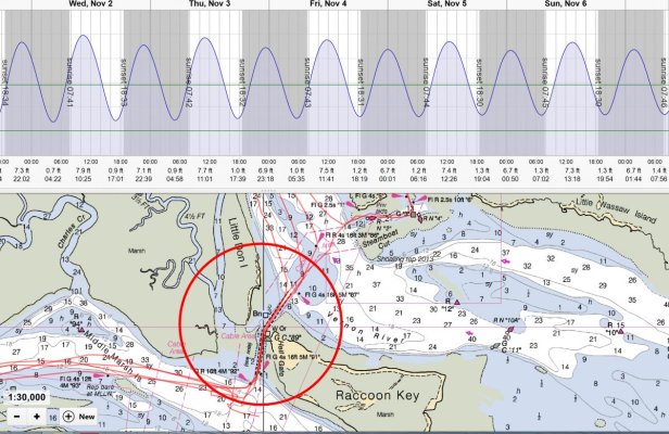
In app tides and currents is one of the deciding factors in the navigation tools I use. Coastal Explorer and OpenCPN both have excellent device resident tides and currents. On my iPAd, Navionics has excellent tide and current information and it is device resident.
Attachments
Lepke
Guru
- Joined
- Jun 19, 2016
- Messages
- 3,035
- Location
- US
- Vessel Name
- Charlie Harper
- Vessel Make
- Wheeler Shipyard 83'
I use Tide Tables & Charts by TIDES.net when I just want tide info and am not running a nav program.
Many more stations than found in nav programs, especially for Alaska.
Many more stations than found in nav programs, especially for Alaska.
ranger58sb
Guru
NOAA has both Tide and Current pages. All stations...
Don't have the links on this computer, but it'seasy to find...
-Chris
Don't have the links on this computer, but it'seasy to find...
-Chris
We always check more than one source for tide data. It’s amazing how different high tide for the same location can vary.
Doug
Senior Member
- Joined
- Aug 15, 2009
- Messages
- 266
- Location
- Victoria, BC Canada
- Vessel Name
- Timeless
- Vessel Make
- CHB 34
Fletcher500
Guru
Agree, for the money Navionics on an IPad along with other reference materials are well worth the money.
dhmeissner
Guru
- Joined
- Sep 26, 2012
- Messages
- 1,569
- Location
- North America
- Vessel Name
- The Promise
- Vessel Make
- Roughwater 35
If you have �� iPhone Ocean Watch is a nice app.
ranger58sb
Guru
NOAA has both Tide and Current pages. All stations...
Don't have the links on this computer, but it'seasy to find...
And now I'm on one of our main computers... These are links we use a lot in our local area. Click around to navigate to where might be useful...
https://tidesandcurrents.noaa.gov/noaatidepredictions.html?id=8575737&legacy=1
https://tidesandcurrents.noaa.gov/stationhome.html?id=8575512
https://tidesandcurrents.noaa.gov/noaacurrents/Predictions?id=ACT4966_1
-Chris
North Baltic sea
Guru
Hmm...
We do not have 6v batteries (another conversation, joke) and it is also not a tide Baltic seas at all and it is really nice at this.
NBs
We do not have 6v batteries (another conversation, joke) and it is also not a tide Baltic seas at all and it is really nice at this.
NBs
Nomad Willy
Guru
14 posts so far and I haven’t seen anthing at all about tides.
dhmeissner
Guru
- Joined
- Sep 26, 2012
- Messages
- 1,569
- Location
- North America
- Vessel Name
- The Promise
- Vessel Make
- Roughwater 35
Lou_tribal
Guru
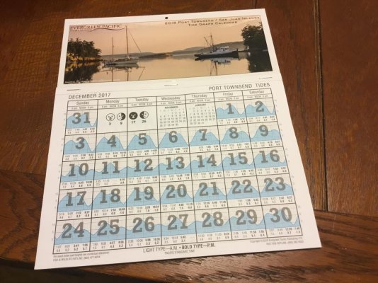
Does this Calendar show the daily snow fall up here?
L
L
Nomad Willy
Guru
Thanks Dave,
Where are they availible?
West Marine or ?.
With that tide table one can factor in the tide differences for (as an example) all of Puget Sound and the islands. If I had the chart for Everett or LaConner it should be easy. For as often as I need tide information this should do fine.
Where are they availible?
West Marine or ?.
With that tide table one can factor in the tide differences for (as an example) all of Puget Sound and the islands. If I had the chart for Everett or LaConner it should be easy. For as often as I need tide information this should do fine.
Last edited:
JDCAVE
Guru
- Joined
- Apr 3, 2011
- Messages
- 2,912
- Location
- Canada
- Vessel Name
- Phoenix Hunter
- Vessel Make
- Kadey Krogen 42 (1985)
We always check more than one source for tide data. It’s amazing how different high tide for the same location can vary.
Yes. For sure! But it’s kinda like having two clocks—which one is correct?
For the BC coast, travel through any passes with strong currents should be verified using the CHS tables. For example the tables on AyeTides for Malibu Rapids are uniformly wrong as are the tables on Coastal Explorer for Dent Rapids.
Jim
Ole Hank
Veteran Member
- Joined
- Feb 7, 2017
- Messages
- 66
- Location
- USA
- Vessel Name
- Hanks Dream
- Vessel Make
- Beneteau Swift Trawler44
I just bought a 2 in 1 PC. I use Navionics on an iPad but am looking to move to PC only. So right now I am also looking for nav software on PC.Doesn't your navigation program have tides?
Or do you not have one on your computer? If not, you should get one.
Irish Rambler
Guru
- Joined
- Apr 29, 2014
- Messages
- 1,733
- Location
- FRANCE
- Vessel Name
- 'Snow Mouse.'
- Vessel Make
- BROOM FLYBRIDGE 42.
Buy a set of tide tables showing standard ports and secondary port variations.
Paper charts have tidal streams on the back, if you cant understand it without a computer go back to night school.
I don't mean to be rude or abrasive but if you can do simple mental arithmetic and count to twelve you can work it out in your head.
If you're new to the sea go to the first seaport, moor there for a week, watch and learn the rhythm of the weather and the sea.
dhmeissner
Guru
- Joined
- Sep 26, 2012
- Messages
- 1,569
- Location
- North America
- Vessel Name
- The Promise
- Vessel Make
- Roughwater 35
Thanks Dave,
Where are they availible?
West Marine or ?.
With that tide table one can factor in the tide differences for (as an example) all of Puget Sound and the islands. If I had the chart for Everett or LaConner it should be easy. For as often as I need tide information this should do fine.
I got this one at the NW maritime center in Port Townsend. I think Fisheries has them no sure about WM.
Ole Hank
Veteran Member
- Joined
- Feb 7, 2017
- Messages
- 66
- Location
- USA
- Vessel Name
- Hanks Dream
- Vessel Make
- Beneteau Swift Trawler44
Lol I'd call it more ignorant than rude. In this century it's just nice to have convenience and speed when it's there. But thanks for your input.Buy a set of tide tables showing standard ports and secondary port variations.
Paper charts have tidal streams on the back, if you cant understand it without a computer go back to night school.
I don't mean to be rude or abrasive but if you can do simple mental arithmetic and count to twelve you can work it out in your head.
If you're new to the sea go to the first seaport, moor there for a week, watch and learn the rhythm of the weather and the sea.
Maerin
Guru
I use AyeTides on my iPhone. I find it's really handy for planning departures or other tide-dependent activities without having to dig out a table or book when the computer's not running. The app has a GPS function that finds the closest station.
While underway, it's CE and its tide/current functions. Couldn't be easier, <shift> T for tides, <shift> C for currents.
While underway, it's CE and its tide/current functions. Couldn't be easier, <shift> T for tides, <shift> C for currents.
psneeld
Guru
Buy a set of tide tables showing standard ports and secondary port variations.
Paper charts have tidal streams on the back, if you cant understand it without a computer go back to night school.
I don't mean to be rude or abrasive but if you can do simple mental arithmetic and count to twelve you can work it out in your head.
If you're new to the sea go to the first seaport, moor there for a week, watch and learn the rhythm of the weather and the sea.
What about seaports with diurnal tides? Or worse, mixed, semi-diurnal?
My paper charts are blank on the back....or just another chart, nothing with tides unless you are talking charts of tidal ranges.
Learning rythm in one week doesnt mean the same size tides the next.
And I agree with the OP, why bother with the calculating, when a single click can give it instantly plus a couple clicks more to change dates?
Plus the graphics are going to show the "rhythm" a lot quicker than sitting for days to get a miniscule glimpse of tidal changes.
I am old school in a lot of things...but this is about data more than seamanship....and getting it easy isnt bad.
Last edited:
Ken E.
Guru
- Joined
- Nov 12, 2016
- Messages
- 1,978
- Location
- United States
- Vessel Name
- Hatt Trick
- Vessel Make
- 45' Hatteras Convertible
The Ports and Passes annual book covers PNW for tides and currents, WA, BC and SE AK. Available online or from places like LFS. Around $20. Lots of info.
Similar threads
- Replies
- 55
- Views
- 4K
- Replies
- 22
- Views
- 9K
Latest posts
-

-

-
-
-

-

-

-
-
 Fixing boats in Exotic Places - are new boats really that bad?
- Latest: HeadMistress
-