Coastal Explorer iPad version (beta)

The friendliest place on the web for anyone who enjoys boating.
If you have answers, please help by responding to the unanswered posts.
Joined
Jul 3, 2017
Messages
1,015
Location
United States
Vessel Name
FORTITUDE
Vessel Make
Kadey Krogen 54-8
Coastal Explorer was showing off a very cool beta of their iPad version at the Seattle Boat Show. Very impressive capabilities on the iPad in that it's not a "mirror" app for the MFD but a completely functional, independent CE app that can connect to your network through a NEMO Gateway. They mentioned Android version would be coming out later.

They also have some nice new features like route collection sharing and POI markers for things like your YC outstations of fishing sports coming out in CE.

The more I use CE and get to know the company the more I lean toward PC/table based navigation.

Now if they can come up with some radar integrations it'll be a true replacement option for proprietary MFDs.
 
What I would like is, the ability to drop bread crumbs along an auto pilot trip and then, punch a button to totally reverse course.
 
What I would like is, the ability to drop bread crumbs along an auto pilot trip and then, punch a button to totally reverse course.

Dan, CE does have a reverse course feature. You access it from the planner.
 
I've used CE since they started. Really good folks. I especially like their integration with Active Captain as I can see the AC icons at a decent zoom-out level. Glad they are staying current. Over the years, they have been very generous with their upgrade policy which is really nice. I find it easier to use than OpenCPN, which means my crew doesn't wake me in the middle of their nighttime watch to ask questions.

Only feature they lack that I sorely miss is GRIB file fetch and display.
 
PC & tablet navigation was the better way to navigate electronically back when stand alone GPS plotters were slow, charts had minimal detail and displays were small and hard to see in sunlight.

MFD's have come a long way. They are faster, have more memory and large displays.

But, I still prefer navigating on my laptop running Nobeltec VNS. I was a Nobeltec dealer for over 20 years and VNS was and still the easiest to use.

I started selling CE when it was introduced. It is popular with boaters switching from Nobeltec. It is more similar to the old Nobeltec VNS than the Nobeltec Time Zero.

CE doesn't try to sell upgrades and charts every few years like Nobeltec did.

Their tablet based app will be very popular.

Using a PC/laptop for radar is not that great of a feature. It works good as a display but making adjustments is not as intuitive as a real radar. Nobeltec gave me one of their PC radars for demo but I didn't use it that much. Too hard to adjust and I prefer separate displays for my electronics. The radar overlay feature was new then and at that time promising. But after using it for a while, could'nt see the benefit.
 
What I would like is, the ability to drop bread crumbs along an auto pilot trip and then, punch a button to totally reverse course.

Most plotters, MFD or PC has a reverse course function.

I don't use it without some changes because I don't travel the same course coming and going. I might be traveling at the wrong side of the channel for the direction.

I make a copy of the original course, rename it and make changes to the course appropriate for the direction of travel. Which is simple to do on a PC based navigation program.
 
Hi

What is GRIB?
Weather files. For example, OpenCPN uses SailDocs - it's a bit clunky, but you send an OpenCPN formatted email to a SailDocs email address and it returns a data email (GRIB file) that is then overplayed onto your chart to provide route planning and wx forecasting - seas, winds, etc. Uses GFS model. Pretty handy.
 
PC & tablet navigation was the better way to navigate electronically back when stand alone GPS plotters were slow, charts had minimal detail and displays were small and hard to see in sunlight.

MFD's have come a long way. They are faster, have more memory and large displays.

But, I still prefer navigating on my laptop running Nobeltec VNS. I was a Nobeltec dealer for over 20 years and VNS was and still the easiest to use.

I started selling CE when it was introduced. It is popular with boaters switching from Nobeltec. It is more similar to the old Nobeltec VNS than the Nobeltec Time Zero.

CE doesn't try to sell upgrades and charts every few years like Nobeltec did.

Their tablet based app will be very popular.

Using a PC/laptop for radar is not that great of a feature. It works good as a display but making adjustments is not as intuitive as a real radar. Nobeltec gave me one of their PC radars for demo but I didn't use it that much. Too hard to adjust and I prefer separate displays for my electronics. The radar overlay feature was new then and at that time promising. But after using it for a while, could'nt see the benefit.
By far, easier to do route planning on a PC vs an MFD, even an MFD with a knob input vs touchscreen (Furuno and Simrad both have models with knob inputs). Slightly geeky, but uploading from PC to MFD is usually pretty straightforward (I'll figure my system out once she's relaunched in a few months). From there, you can groom the course underway if needed.
 
I looked at the CE's site, looks interesting.
They dont seem to want to post the price of the basic nor upgrade.
Does someone know?
If I d/l to my computer will it also load to my iPad at no additional price?
 
I looked at the CE's site, looks interesting.
They dont seem to want to post the price of the basic nor upgrade.
Does someone know?
If I d/l to my computer will it also load to my iPad at no additional price?
$379. 10-day fully functional trial version for no charge. Lot of money. All I can tell you is they honored my original purchase 10-years after I had last used it. I think it might have been $99 to reactivate.

Lot of money. But it is a nice program. OpenCPN is free. But I find it difficult to use but many love it (probably due to free price).

https://www.rosepoint.com/coastal-explorer/download
 
I looked at the CE's site, looks interesting.
They dont seem to want to post the price of the basic nor upgrade.
Does someone know?
If I d/l to my computer will it also load to my iPad at no additional price?

PM me and I can give you a quote. CE has minimum advertised pricing rules for dealers so I can't post it here.

You download the software, try it for free. If you like it, I have Rose Point email you the unlock code and you pay me via PayPal.
 
Last edited:
PM me and I can give you a quote. CE has minimum advertised pricing rules for dealers so I can't post it here.

You download the software, try it for free. If you like it, I have Rose Point email you the unlock code and you pay me via PayPal.

You are a dealer?

Can I load it both to my laptop and iPad for the same price?
Yes, I see the free week offer. I think I wil save that free offer until I am closer to needing it.

Per PayPal..... I haven't use it in years so needless to say, the probability of me remembering my password is pretty close to a negative value. LOL There is always hope.

I am a dealer.

I'm pretty sure you can but let me check with Rose Point tomorrow. I need to email them to get 2020 pricing and policy. And any promotions.

They allow 3 installs per license. I'm not sure if that includes the iPad/Android versions.
 
Last edited:
I am a dealer.

I'm pretty sure you can but let me check with Rose Point tomorrow. I need to email them to get 2020 pricing and policy. And any promotions.

They allow 3 installs per license. I'm not sure if that includes the iPad/Android versions.

Thanks. Nice to know the dealer willing to provide support too.
 
I am a dealer.

I'm pretty sure you can but let me check with Rose Point tomorrow. I need to email them to get 2020 pricing and policy. And any promotions.

They allow 3 installs per license. I'm not sure if that includes the iPad/Android versions.

It would be really interesting to know. I just purchased the latest version of CE in 2018 and it would be skookum to be able to DL an android version to my tablet. I just this week was working on getting the tablet (running opencpn) configured to connect to my nemo with WIFI, but I would much prefer to keep the tablet and computer both on CE if they end up releasing an android port. Unfortunately I need to keep the android tablet around for all the other marine gadgets I seem to have acquired!!!
 
What I would like is, the ability to drop bread crumbs along an auto pilot trip and then, punch a button to totally reverse course.


I am 99% sure this in a feature in CE already. You can take a track (your break crumbs) and convert it into a route. And once you have a route, you can follow it in either direction. That last part I'm 100% certain about as I've used in 100's of times.
 
I'm amazed anyone balks at the price of CE. I think it's the least expensive item in a navigation suite, and probably the most useful part. I replaced probably $6000 work of cumbersome and unreliable MFDs with CE and never looked back.


Since I'm between boats, I haven't been keeping up with Rose Point's activities, but while I had my last boat I was quite involved, helped track down a variety of obscure issues, and did alpha and beta testing on Nemo for almost 18 months before it was released. They are an awesome company, very customer focused, and one of the very few who take reported issues seriously, investigate them, and fix them promptly. Most companies do everything they can to insulate themselves from their customers, spend their effort blaming problems on other things, and never even look into or fix their own bugs.


I think this break from Windows is a huge step in the right direction. Windows has been the biggest draw back and weakness in CE, and is especially problematic with Windows 10 where it insists on doing huge updates, even if over you expensive internet connection.


Now, can I run the Andriod OS on some black box hardware like a NUC or Pi and use my large screens with a keyboard and mouse? I'd be all over that. Basically what I have been running, except slide out Windows and slide in something better.
 
I'm amazed anyone balks at the price of CE. I think it's the least expensive item in a navigation suite, and probably the most useful part. I replaced probably $6000 work of cumbersome and unreliable MFDs with CE and never looked back.

I agree, though with some hesitation. I've been in a boating coma for 10+ years so lost track of the art-of-the-possible until last year when I started my refit process (and joined this forum). My hunch is most folks find Navionics and MFDs perfectly adequate for their boating needs - no reason to complicate their helm and life, so the extra $$$ is a waste. Every voyaging vessel needs a single-source-of-truth navigation system, be it a sextant or a full-blown black-box/multi-display system. The new integrated MFD systems start at $5k, and a decent one with repeaters at logical places can be had for around $8k. All of which are quantum leaps better than what was available just 20-years ago at any price. I recently posted a BBC video of Eric & Susan Hiscock from 1963 of their 3-year circumnavigation aboard a 30-foot boat - they hand-steered the entire way as there simply was no other choice except setting twin headsails in some conditions (Windvane steering was invented shortly after their trip). To my thinking, the original "Trawler Forum" was mimeographed newsletters of Willard 36 owners from the 1960's detailing trips to Baja CA, Panama Canal, the Galapagos Islands, Hawaii and other places - I don't even think RDF was practical back then.

I met Brad at Rose Point very early on, just after he left Microsoft with this crazy idea to launch a navigation suite. As you mention, the company seems to have remained the same since then - not just customer service, but customer dedication.

My long-winded point is I agree with TT, though I think one of my ah-ha revelations about TF since joining last year is I thought trawler owners did more distance voyaging. Now, powerboat owners who voyage distances often chose a trawler, but the inverse is not true: trawler owners are not always distance travelers, they're just blokes who like the look/feel/roominess/economy of a trawler-style boat. Those latter owners have little use for adjunct navigation aids. Nordhavn owners, such as TT, are almost exclusively in the first camp - distance travelers, often with the means and perceived need for a 6-figure navigation setup (please, only an observation from having hung around the Dana Point docks for a while watching boats get commissioned).


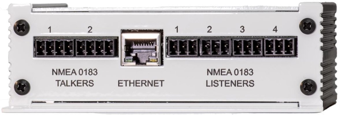
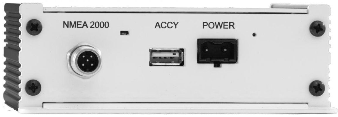
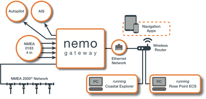
The above said, I can tell you that as a result of this thread, I will seriously look at the Nemo interface (decent intro video here) and feel it may be a really good value ($550) assuming a smooth interface into my Simrad system. I love my old Comnav 2001 Autopilot (0183), but when my Furuno Radar died 2-days before I was headed south, I pressed my still-in-the-box Simrad MFD/Radar into service in a quick install. I was not able to get the 0183 A/P interface to function with my Simrad. Granted, I didn't try very hard as I had a million other things to do, but it seemed like it should have been easy and it wasn't. For my 500nm delivery from San Francisco to Ensenada, I decided to just run the A/P heading manually - heck, there were less than a dozen waypoints to get the 500nms, so not a big deal. But having everything interfaced is nice - let's me sleep better during my off-watch at night.
 
I’m really looking forward to this. I’ve always wanted to be able to have a “reverse screen mirror” of what is on my CE to my iPad.

Jim
 
I think this break from Windows is a huge step in the right direction. Windows has been the biggest draw back and weakness in CE, and is especially problematic with Windows 10 where it insists on doing huge updates, even if over you expensive internet connection...

Chuckle! THAT’s why my NUC is off-line! I take it home for windows updates...on my schedule!

Jim
 
I have been a CE aficionado since very early on. In around 1998 I started with a big clunky portable computer (almost a laptop but not quite) with a The Captain nav software. CE running on a laptop sat next to my Garmin 7208 chart plotter on the trawler and now my circa-2005 Furuno MFD whenever I leave my home bays. I keep CE on my desktop and two laptops, one a relatively small form factor for use on my now smaller boat. I cannot tell you how many transfers on license I have done over the years when a computer craps out. I just call CE and cancel out the messed up computer and give them the name of the new one and then reload the program from the disk I have and then update it online with them. There is a sponsored forum of users there too, very helpful. I have a cable between the Furuno Navnet VX2 MFD and the laptop to transfer any of the many, many CE routes I have on the laptop utility for that. The Furuno is far too clunky to plan any longer route on. I would imagine that I would not be allowed to cancel one of my computers and get CE on my iPad because it is a different program than my licensed version, but you never know. It will be interesting the see the answer here. I wouldn't do it anyway since I do not consider the iPad a worthy instrument to navigate with.
 
I'm amazed anyone balks at the price of CE. I think it's the least expensive item in a navigation suite, and probably the most useful part. I replaced probably $6000 work of cumbersome and unreliable MFDs with CE and never looked back.


Since I'm between boats, I haven't been keeping up with Rose Point's activities, but while I had my last boat I was quite involved, helped track down a variety of obscure issues, and did alpha and beta testing on Nemo for almost 18 months before it was released. They are an awesome company, very customer focused, and one of the very few who take reported issues seriously, investigate them, and fix them promptly.
.

I'm not balking; just hoping I get an android upgrade. Upgrading to the newest CE and buying a Nemo was the very first thing I did for NWD. I'm seeing enough value in having a navigation suite on an andoid tablet that I would strongly consider CE on the android in addition to a nav computer. Not sure I would switch to an android only solution though. On our last trip I had the tablet on the bedside table at night with opencpn running with an anchor alarm, and I could quickly turn the screen on for a position update if I wanted some reassurance or to check our set.

...and I thank you for all your Beta work on the Nemo. It worked perfectly right out of the box, connecting my Gigabyte laptop, twin Garmin 4212's, ComNav 2001, VHF radio, and AIS without me having to touch a setting.

Although I must confess having some trouble keeping the laptop seeing the NMEA data from the Nemo if the laptop is put to sleep or if the WIFI is accidentally powered off...I just tried WIFI instead of a network cable for the first time this last trip two weeks ago.
 
I talked to Rose Point today and received information about the iPad/iPhone version of CE.

The beta version is available for free to owners of CE here:

https://community.rosepoint.com

Once the retail version of the iPhone/iPad is available for sale in a few months, the beta version will become a trial retail version and you can purchase it at that time for $100. If you elect not to buy it, the Beta version will become unusable.

The iPad/iPhone CE app will be offered as a separate app from the PC version. Because it's Apple, it will only be available from the Apple Store for $100/year. I don't think dealers will be able to sell the iphone/iPad version because of bad Apples policies - no discounted pricing. From what I got from my conversation with the Rose Point rep, once you purchase the app, you can install it on unlimited devices. A lot of the App features and selling policies will not be finalized until the Beta version development and testing is completed.

The Android version will come out in 8 to 12 months after the iPhone/iPad versions retail release.

The PC version of Coastal Explorer retails for $399, it is MAP protected and the lowest advertised price allowed is $369

If you download a trial version of CE for PC and wish to buy the software, I can have Rose Point email you the unlock code for $329. On a group buy of 5, $299 each.

The NEMO Gateway retails at $699, MAP is $649. I usually sell these for $579 but Rose Point is running a Seattle Boat show special of $550 until the end of February.

Rose Point is giving me an additional discount so that I can match the $550 price.

PM me if interested in a purchase. Question about CE should be asked and answered here.
 
Last edited:
NEMO Features and Specifications
Certified NMEA 2000® interface
Four true NMEA 0183 optically-isolated listeners, each high speed (NMEA 0183-HS) capable
Two true NMEA 0183 differential talkers, each high speed (NMEA 0183-HS) capable
Automatic interfacing with Coastal Explorer and Rose Point ECS
Compatible with many PC, macOS, iOS, Android, and other third-party navigation applications
Easily configured with Coastal Explorer, Rose Point ECS or the Nemo Gateway app for iOS or Android
Bidirectionally converts common NMEA 2000® PGNs and NMEA 0183 sentences
Redundant sensor management with automatic failover
Provides common network protocol (UDP and TCP) access to your NMEA data
Simultaneous connections with multiple systems
Additional signal standards supported: IEC 61162-1, IEC 61162-2, RS-422, RS-232
Auto-switching RJ45 Fast Ethernet port
Removable terminal blocks offer easy power and NMEA 0183 wiring
Accepts wide-range 8-32 volt DC power with conditioning and protection
Low average current draw – 0.2 amps (12v), 0.1 amps (24V)
Dimensions: 5” x 5” x 1-3/4” (including mounting flange)
Weight: 12.9oz
 

Attachments

  • Nemo Ports.jpg
    Nemo Ports.jpg
    60.1 KB · Views: 50
  • Nemo Power.jpg
    Nemo Power.jpg
    37.1 KB · Views: 50
  • Diagram-Nemo-1.png
    Diagram-Nemo-1.png
    71 KB · Views: 56
I want to use my GPS function to identify my current location then, put in the desired destination, either by name of city or port or Lat/Long, resulting in a recommended course and speed made up of proposed waypoints then allowing the user to refine the the proposed voyage along the way.
Automatic popup of current and projected weather warning along the way.
I guess we should also have a loss of GPS signal and anchor drag alarm.
Perhaps one final wish ..... a scheduled, resettable alarm to make sure the helms person is present and awake.

How's that for a wish list?
 
Last edited:
I want to use my GPS function to identify my current location then, put in the desired destination, either by name of city or port or Lat/Long, resulting in a recommended course and speed made up of proposed waypoints then allowing the user to refine the the proposed voyage along the way.
Automatic popup of current and projected weather warning along the way.
I guess we should also have a loss of GPS signal and anchor drag alarm.

How's that for a wish list?

Most PC based navigation programs and newer chartplotter will create a course if you provide a start location and destination. Most also allow weather warnings and set up an anchor warning.

The auto course creation is questionable in accuracy and usefulness. It plots the shortest route with the least number of waypoints/course changes, taking into account depth and obstructions on the route. There are examples of boaters running aground or hitting rocks using auto course creation. They did not review the created course before following it and missed shallows or rocks. The time required to review and correct auto created routes is not much less than creating and proofing a route.

Creating routes manually on a PC is fairly easy and quick. Existing routes saved on the PC can be copied, modified, reversed, shortened, lengthened, split, joined, waypoints added, deleted, moved, renamed etc. Name and save every route created and eventually you only create routes to new destinations.

Additionally, when following a routes through narrow sections, a seasoned boater selects the side of the channel to follow based on current, traffic and weather.
 
Last edited:
I want to use my GPS function to identify my current location then, put in the desired destination, either by name of city or port or Lat/Long, resulting in a recommended course and speed made up of proposed waypoints then allowing the user to refine the the proposed voyage along the way.
Automatic popup of current and projected weather warning along the way.
I guess we should also have a loss of GPS signal and anchor drag alarm.
Perhaps one final wish ..... a scheduled, resettable alarm to make sure the helms person is present and awake.

How's that for a wish list?

Dan, I'm familiar with this feature from Garmin/Navionics. As I understand it CE does not perform any auto-routing. What it does do is allow you to select a destination (searchable) and then it will create a course line to your destination. Keep in mind this can create a route over land or through hazardous areas.

Once setup you just adjust the course by adding waypoints and adjust your planned course. The software will alert you to various things along the way based on your input parameters like draft. It will also alert you to restricted areas, etc. Planned routes can be saved, reversed and as I understand it in the beta, shared.

Once complete you save the plan, activate it and if you have NEMO and everything connected, your good to go and see your boat against the plan, complete with course correction recommendations.

In my case it's connected to the GPS, the AP, electronic compass, Vesper AIS, etc.
 
Last edited:

Latest posts

Back
Top Bottom