You are using an out of date browser. It may not display this or other websites correctly.
You should upgrade or use an alternative browser.
You should upgrade or use an alternative browser.
Hurricane Irma
- Thread starter 101TUG
- Start date
The friendliest place on the web for anyone who enjoys boating.
If you have answers, please help by responding to the unanswered posts.
If you have answers, please help by responding to the unanswered posts.
rclarke246
Senior Member
- Joined
- Mar 17, 2014
- Messages
- 450
- Location
- USA
- Vessel Name
- Lady Di
- Vessel Make
- 2012 Beneteau Swift Trawler 44
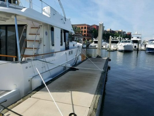
Looks like Marco Island, south of Naples, FL may be ground zero! Lady Di is spider-web-tied in her floating slip at Esplanade Marina, Smokehouse Bay, Marco. Every cleat, line & fender is deployed. Windows and doors Gorilla Taped.
My biggest concerns: 1) storm surge overwhelms the floating piers. I estimate about 9' will do it. 2) another boat breaks loose and sinks her.
We're up north, thank God!
I'll let you know...
My biggest concerns: 1) storm surge overwhelms the floating piers. I estimate about 9' will do it. 2) another boat breaks loose and sinks her.
We're up north, thank God!
I'll let you know...
Attachments
Last edited:
HopCar
Guru
- Joined
- Aug 20, 2011
- Messages
- 5,311
- Vessel Name
- Possum
- Vessel Make
- Ellis 28
As to cell phones- good luck with that after a hurricane. Gotta keep the land line.
leeman
The land line will go out when the poles come down or a tree falls across the wire. I'm betting the cell towers get put back sooner than the land lines. They have portable towers that can be brought in and erected pretty quickly after a storm. They call them COWS, cell on wheels.
I took my satellite dish down today so no tv. I bought one of those indoor digital antennas but I can't make it work.
I bet I lose my bee hives. I've got two in my backyard. I put a bucket filled with concrete on top of each. We'll see what happens.
My battery powered tools have been a tremendous help. I've drilled concrete and wood today. I've cut steel angle iron. I driven a bunch of screws both into wood and concrete. I've removed nuts and I've driven nails all with Ryobi battery tools.
Sorry I'm rambling, I'm exhausted.
Oh ya, the boat. It's tied along side the dock behind my old store on the Miami river. Doubled the lines, removed all canvass and cushions. Have two working 12v bilge pumps. Batteries fully charged with the charger on as long as there is power. Also have a 110v bilge pump. Vacuumed the bilge.
There is a tree that will might fall on poor old Possum but it is the best I could do. It will probably kill my insurance agent to write that check.
I also tried something a little different. My cockpit hatches leak and are a pretty loose fit in the hole. I tried caulking them with some 1/8" nylon braid driven into the gap between hatch frame and hatch lid. It might not be water tight but it will slow down the water.
I'm a GA and commercial pilot. That is absolutely unreal that they closed the airport like that. I get shutting the tower down, but closing the airport and holding all of those planes is unreal. I'd be calling your local FSBO immidiatly. Obviously there's nothing unsafe at the moment, so maybe there's a way they can legally open the airport long enough to let you guys get out of there.
Steve91T,
I called the Governor, and the commissioners. No one answered and they really don't give a ****... just a bunch of BS. I heard governor Scott giving a speech IN St. Pete today and gave out an emergency number. I called it several times and went unanswered.
If the forecast continues, I'll be ok. It Irma swings out over the gulf and comes back in, I'll take my bolt cutters and cut thru the fence to get my plane out.
Yes, it's totally stupid and rules made by idiots that just don't know anything about airports. Allegient cancelled many flights that folks could have used to get out of town. And many GA guys were totally pissed at the airport this morning.
Weather is perfect VFR and will be flyable easily until Sun morn.
Yes, there will be some action after this is over.
Alemao
Guru
Irma turning cat 3, well organized and coming on Caribbean.
I plan sunday to going South, Hope Irma making more North and not going to hit us.
Any other people from Trawler Forum in Caribbean and what are you doing?
Hugues
My boat is in St Maarten, in Bobbys Megayard and I don't have any news until now
HopCar
Guru
- Joined
- Aug 20, 2011
- Messages
- 5,311
- Vessel Name
- Possum
- Vessel Make
- Ellis 28
Steve91T,
I called the Governor, and the commissioners. No one answered and they really don't give a ****... just a bunch of BS. I heard governor Scott giving a speech IN St. Pete today and gave out an emergency number. I called it several times and went unanswered.
If the forecast continues, I'll be ok. It Irma swings out over the gulf and comes back in, I'll take my bolt cutters and cut thru the fence to get my plane out.
Yes, it's totally stupid and rules made by idiots that just don't know anything about airports. Allegient cancelled many flights that folks could have used to get out of town. And many GA guys were totally pissed at the airport this morning.
Weather is perfect VFR and will be flyable easily until Sun morn.
Yes, there will be some action after this is over.
I agree, that's stupid. It was perfect flying weather today and will probably be fine tomorrow. A lot of planes could be flown out in two days. The AOPA and EAA should get all over them for this.
cardude01
Guru
- Joined
- Nov 26, 2012
- Messages
- 5,290
- Location
- USA
- Vessel Name
- Bijou
- Vessel Make
- 2008 Island Packet PY/SP
Steve91T,
I called the Governor, and the commissioners. No one answered and they really don't give a ****... just a bunch of BS. I heard governor Scott giving a speech IN St. Pete today and gave out an emergency number. I called it several times and went unanswered.
If the forecast continues, I'll be ok. It Irma swings out over the gulf and comes back in, I'll take my bolt cutters and cut thru the fence to get my plane out.
Yes, it's totally stupid and rules made by idiots that just don't know anything about airports. Allegient cancelled many flights that folks could have used to get out of town. And many GA guys were totally pissed at the airport this morning.
Weather is perfect VFR and will be flyable easily until Sun morn.
Yes, there will be some action after this is over.
Dude. That really sucks. Get on their ass.
healhustler
Guru
- Joined
- Oct 2, 2009
- Messages
- 5,198
- Location
- USA
- Vessel Name
- Bucky
- Vessel Make
- Krogen Manatee 36 North Sea
A surprise for us too. Looked real good for us 36 hours before the noon today mandatory evacuation order.
Steve91T
Guru
- Joined
- Sep 12, 2016
- Messages
- 898
- Location
- USA
- Vessel Name
- Abeona
- Vessel Make
- Marine Trader 47’ Sundeck
Steve91T,
I called the Governor, and the commissioners. No one answered and they really don't give a ****... just a bunch of BS. I heard governor Scott giving a speech IN St. Pete today and gave out an emergency number. I called it several times and went unanswered.
If the forecast continues, I'll be ok. It Irma swings out over the gulf and comes back in, I'll take my bolt cutters and cut thru the fence to get my plane out.
Yes, it's totally stupid and rules made by idiots that just don't know anything about airports. Allegient cancelled many flights that folks could have used to get out of town. And many GA guys were totally pissed at the airport this morning.
Weather is perfect VFR and will be flyable easily until Sun morn.
Yes, there will be some action after this is over.
Try the FAA.
A reporter made a big deal out of a beach side pizza parlor and a liquor store being open. Didn't seem to grasp that they could still make it home, five miles away, before tomorrow.
Here's the current wind forecast where we are:
Accuweather and Weather.com
Saturday
0600 16NE 25NE (all mph)
1000 25NE 38NE
1400 44NE 42ENE
1700 58NE 44ENE
1900 53NE 48ENE
2300 50NE 71ENE
Sunday
0000 67NE 70ENE
0200 63NE 88ENE
0300 56NE 95E
0400 56W 108E
0600 62SSW127E
0700 66SSW102ESE
0900 71S 91ESE
1000 77SSE 93ESE
1100 64SE 102ESE
1200 77SE 102ESE
1400 98SSE 100SE
1500 77SSE 104SE
1600 89S 106SE
1800 84S 91SSE
1900 79SSW76S
2200 67SW
Monday
0100 47SW
0200 60SW
0400 48SW
0700 41SSW
0800 23SSW
1000 9SW
What I found interesting is 41 hours above 40 mph, strengthening and weakening as it turns, and per Accuweather it peaks at 98 mph while per Weather.com it peaks at 127 mph. National Weather Service peaks at 80 mph. Strong winds nearly two days more because we're on the west side of the storm than if we were in it's line.
For us it starts in less than 19 hours.
Just shows how much different in forecasts this close to the storm and it's the same for all area. So we plan for 127 mph and hope it doesn't top 80.
O C Diver
Guru
- Joined
- Dec 16, 2010
- Messages
- 12,880
- Location
- USA
- Vessel Name
- Slow Hand
- Vessel Make
- Cherubini Independence 45
Question:
About how long will 8 new AGM 6 volt batteries on a Magnum Inverter keep a Norcold double door refrigerator/freezer going if it is the only 110v load?
Would it be better to run the refer off 12 volts instead?
We are in Riviera Dunes Marina in Palmetto...south of Tampa Bay...and just found out that they cutting power at noon tomorrow. Not being kicked out per se. Can run the genny and stay if we wish.
Better to turn off the inverter portion (leave on the battery charger ) and run the norcold on 12 volts. You will draw less out of the batteries. Might last 3 to 4 days that way.
Ted
I gotta tell ya, judgmental opinions about other people's lack of storm preparation or their general intelligence, coming from someone 3500 miles away, don't impress me...at least not in a positive way. It does indicate a lack of empathy and a narcissistic attitude. I'm
So just to defend a few million "stupid" people down here in Texas - your brilliant buddy on the hill notwithstanding - please know that 80% of the flooded homes didn't have - were not REQUIRED to have - flood insurance BECAUSE THEY WERE NOT IN THE FLOOD PLAIN. Otherwise their mortgage companies would have required it. Several well-regarded scientists around the country are calling our part of Harvey's destruction a 10-20,000 year rain event.
I am in the 500 year flood zone like almost everyone else in the middle areas of Houston. I do have flood insurance. My house is 63 years old and has never come close to being flooded. But my mortgage company requires it. In fact my elevation is actually higher than what the County has on the books. I got a discount on my premium for that. And I had 18" of water in my living room two weeks ago.
By the way, do you hear me whining about this flood? Do you hear anybody else around here whining?
Perhaps I am stupid for living in a home that is near my work and has nearly doubled in value since 2010. Perhaps I should have built a 6' berm around my urban home last January, instead of playing golf. Perhaps the Allen brothers shouldn't have started a town here in the 1800's. Perhaps the many low-income families who flooded for the first time ever should have gotten a college education, made more money, stockpiled Evian water and solar cell phone chargers last March and moved to a planned community. Although those flooded too. Fact is, the low and middle income folks were a little busy working seven days a week stocking plywood for the rest of us idiots at Home Depot. I don't know why...we weren't buying it anyway. Morons. Why didn't they plan better during their spare time?
Look, it rained 50". Fifty. No storm surge. I'm 49 ft above sea level and 35 miles from the nearest salt water. I'm not sure if, with 3 days notice, the 100,000 now flooded home owners and their families could have been "expected" to prepare for that. After all, it's never happened. Ever.
Certainly the 1000's of affected small businesses didn't plan on it. Their fault I suppose. The Home Depot in my area has Aggreko providing temp power and trying to dry their 125,000 s.f. store out - losing millions in revenue over the past 2 weeks. HD's Development people just didn't think ahead I guess. Should have set up shop elsewhere. Same for the people of St Martin, right? Or Barbuda.
I could - if I were a political person - say something about how the highly intelligent people of Alaska once elected a now-former governor who's about as sharp as a bowling ball. But I'm not. So I won't. And I'm not going to sit on my yacht and judge people's life decisions from 3500 miles away. Especially if I didn't know what I was talking about.
Maybe your buddy on his hill should get off his *ss and offer help to all the idiots instead of being a smug SOB. Otherwise, I'd invite him to shut the **** up.
Steve91T
Guru
- Joined
- Sep 12, 2016
- Messages
- 898
- Location
- USA
- Vessel Name
- Abeona
- Vessel Make
- Marine Trader 47’ Sundeck
I gotta tell ya, judgmental opinions about other people's lack of storm preparation or their general intelligence, coming from someone 3500 miles away, don't impress me...at least not in a positive way. It does indicate a lack of empathy and a narcissistic attitude. I'm
So just to defend a few million "stupid" people down here in Texas - your brilliant buddy on the hill notwithstanding - please know that 80% of the flooded homes didn't have - were not REQUIRED to have - flood insurance BECAUSE THEY WERE NOT IN THE FLOOD PLAIN. Otherwise their mortgage companies would have required it. Several well-regarded scientists around the country are calling our part of Harvey's destruction a 10-20,000 year rain event.
I am in the 500 year flood zone like almost everyone else in the middle areas of Houston. I do have flood insurance. My house is 63 years old and has never come close to being flooded. But my mortgage company requires it. In fact my elevation is actually higher than what the County has on the books. I got a discount on my premium for that. And I had 18" of water in my living room two weeks ago.
By the way, do you hear me whining about this flood? Do you hear anybody else around here whining?
Perhaps I am stupid for living in a home that is near my work and has nearly doubled in value since 2010. Perhaps I should have built a 6' berm around my urban home last January, instead of playing golf. Perhaps the Allen brothers shouldn't have started a town here in the 1800's. Perhaps the many low-income families who flooded for the first time ever should have gotten a college education, made more money, stockpiled Evian water and solar cell phone chargers last March and moved to a planned community. Although those flooded too. Fact is, the low and middle income folks were a little busy working seven days a week stocking plywood for the rest of us idiots at Home Depot. I don't know why...we weren't buying it anyway. Morons. Why didn't they plan better during their spare time?
Look, it rained 50". Fifty. No storm surge. I'm 49 ft above sea level and 35 miles from the nearest salt water. I'm not sure if, with 3 days notice, the 100,000 now flooded home owners and their families could have been "expected" to prepare for that. After all, it's never happened. Ever.
Certainly the 1000's of affected small businesses didn't plan on it. Their fault I suppose. The Home Depot in my area has Aggreko providing temp power and trying to dry their 125,000 s.f. store out - losing millions in revenue over the past 2 weeks. HD's Development people just didn't think ahead I guess. Should have set up shop elsewhere. Same for the people of St Martin, right? Or Barbuda.
I could - if I were a political person - say something about how the highly intelligent people of Alaska once elected a now-former governor who's about as sharp as a bowling ball. But I'm not. So I won't. And I'm not going to sit on my yacht and judge people's life decisions from 3500 miles away. Especially if I didn't know what I was talking about.
Maybe your buddy on his hill should get off his *ss and offer help to all the idiots instead of being a smug SOB. Otherwise, I'd invite him to shut the **** up.
Well said
David Hughes
Senior Member
Looks like Marco Island, south of Naples, FL may be ground zero! Lady Di is spider-web-tied in her floating slip at Esplanade Marina, Smokehouse Bay, Marco. Every cleat, line & fender is deployed. Windows and doors Gorilla Taped.
My biggest concerns: 1) storm surge overwhelms the floating piers. I estimate about 9' will do it. 2) another boat breaks loose and sinks her.
We're up north, thank God!
I'll let you know...
I'm no expert but all I've seen says to avoid cleats on docks as they are the first to go. They say tie directly to the pilings. The pilings won't go anywhere. But that's a great marina, with good protection. Good luck. My boat is at Tarpon Point Marina in Cape Coral. We shall all know by Monday, huh?
Last edited:
I'm no expert but all I've seen says to avoid cleats on docks as they are the first to go. They say tie directly to the pilings. The likings won't go anywhere. But that's a great marina, with good protection. Good luck. My boat is at Tarpon Point Marina in Cape Coral. We shall all know by Monday, huh?
Depends on the cleats but redundancy is good. Some cleats, especially on older wooden docks, are simply bolted through the board and quick to come loose. Others, often seen on newer concrete docks are deeply affixed.
Also depends on the pilings. How deep are they and what kind of force can they handle?
ksanders
Moderator Emeritus
I am 100% with you on this. I'm prepared for any likely event here. Right now it's fire. Preparations started years ago. Some people don't get it, but it just doesn't occur to them. But the standing joke with our friends is if the spam hits the fan,
they're coming here.
As to cell phones- good luck with that after a hurricane. Gotta keep the land line.
leeman
Defendable space. Learned about that when a forest fire burned my entire neighborhood to the ground a couple decades ago
The only homes left on my side of the lake are the ones My family and I were able to save.
We prepared. When the fire started, days before it hit our neighborhood we cleared all the trees. We brought in a fire pump, we fought and we persevered.
Thanks for the comment...
dhays
Guru
- Joined
- May 26, 2015
- Messages
- 9,048
- Location
- United States
- Vessel Name
- Kinship
- Vessel Make
- North Pacific 43
They will be the Zombies
I was just looking...Fema has some really good guides and recomendations for preparing your home to survive a hurricane. Common sense stuff.
I tell people that two weeks without food and water and they will be barbecuing each other.

I assume that you have a month supply of food, water, and fuel for your generator in prep for the earthquake that is bound to hit your area. Of course.... why are you living in an area we know will get hit with a massive earthquake?
Edit: I read later that is exactly what you did.
Last edited:
OP
OP
101TUG
Senior Member
My boat is in St Maarten, in Bobbys Megayard and I don't have any news until now
I have new, no more boat in Megayard, I send one captain to look this is totally mess
I'm sorry about this terrible new.
Hugues
OP
OP
101TUG
Senior Member
so in some hours Jose going to pass near St Barth and all ready turn CAT4 close to 5  :bang head:
hop not hit any island again
we in martinique preparing boat to go up and bring necessity
we load boat friend and my boat 3T one generators (around 25 gen set)
water and food baby necessity +++


:bang head:hop not hit any island again
we in martinique preparing boat to go up and bring necessity
we load boat friend and my boat 3T one generators (around 25 gen set)
water and food baby necessity +++
- Joined
- Mar 17, 2012
- Messages
- 4,280
- Location
- Australia
- Vessel Name
- Insequent
- Vessel Make
- Ocean Alexander 50 Mk I
so in some hours Jose going to pass near St Barth and all ready turn CAT4 close to 5
hop not hit any island again
we in martinique preparing boat to go up and bring necessity
we load boat friend and my boat 3T one generators (around 25 gen set)
water and food baby necessity +++
Excellent Hugues!
I'm sure the Islands that were hit were as well prepared as they could be under the circumstances, and with support from people like you they will get though the short term.
In the longer term, and that's what rebuilding lives, homes and businesses will take, hopefully they can build to higher codes. People will still want to visit those magic places that occasionally suffer from a natural disaster. They are not stupid for wanting to live there, any more than people are stupid for living in areas that sometimes flood. When events get extreme, planning and preparation can get severely tested and the compromises you choose might be different with hindsight.
In Queensland in general, and in Brisbane in particular, during floods of 2017 and 2011 respectively we have been subjected to similar events that have unfolded and are occurring in SE USA. We can offer some empathy.
The aspect I find most disturbing is that the worst impacted are those least able to afford it. They buy or rent homes in flood plains because they are cheaper, they can afford them and still have enough for other life needs. But when the floods do come, and eventually they always do, they lose the most and it takes a greater proportion of their savings and income to recover. A hard cycle to break out of. I guess its why some move away permanently, but you can't do that if its where your work is.
One recent response in Brisbane that will help for future events is that if you home is in a designated flood zone (and zones are being updated) then building height restrictions are increased by 1m. That enables many to get living areas above flood risk when rebuilding. Indeed, you cannot put living space or readily damaged components below flood level. So, on stilts or concrete blocks, with electrical and vulnerable material (sheetrock) allowed only above flood level. Games room/garage or similar can still be there, but are able to be pressured washed and repainted after flooding rather than needing to be torn out and rebuilt.
Last edited:
so in some hours Jose going to pass near St Barth and all ready turn CAT4 close to 5
hop not hit any island again
we in martinique preparing boat to go up and bring necessity
we load boat friend and my boat 3T one generators (around 25 gen set)
water and food baby necessity +++
Fantastic - you are amazing.
MurrayM
Guru
Wasn't Irma at about the maximum theoretical size an Atlantic hurricane could get before the eye drifted over landmasses? This makes me think the models might have a hard time predicting its path, since it is so far beyond the average.
Fletcher500
Guru
Thinking about anyone out there in the storm track. Be safe.
menzies
Guru
We just got the move to a Hurricane Warning from Watch. Meaning if it is coming here in is within 48 hours.
Yet the 11:00am update shows it still moving west over Cuba now as a Cat 3 and slowing to 9mph. They have moved the turning point west again.
Our wind probabilities for Monday are (34/50/64kts): 64/27/7%
Yet the 11:00am update shows it still moving west over Cuba now as a Cat 3 and slowing to 9mph. They have moved the turning point west again.
Our wind probabilities for Monday are (34/50/64kts): 64/27/7%
Similar threads
- Replies
- 48
- Views
- 5K