Aleutian Isle Sinking

The friendliest place on the web for anyone who enjoys boating.
If you have answers, please help by responding to the unanswered posts.

Lepke

Guru
Joined
Jun 19, 2016
Messages
3,039
Location
US
Vessel Name
Charlie Harper
Vessel Make
Wheeler Shipyard 83'
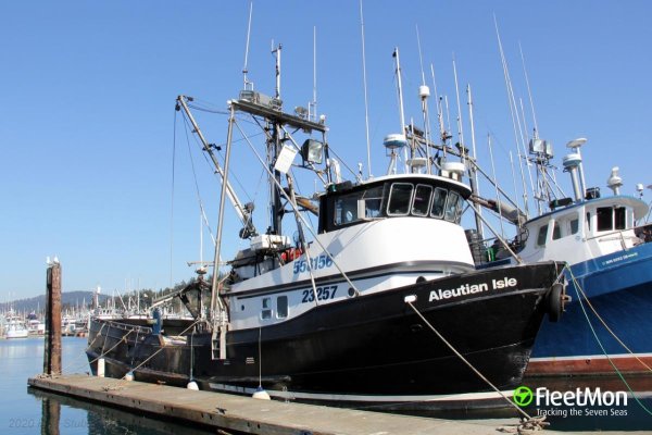
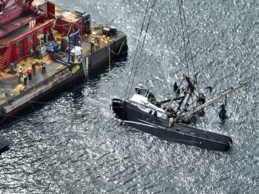
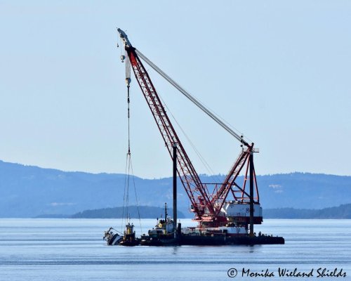
Attachments

  • aleutian-isle.jpg
    aleutian-isle.jpg
    119.4 KB · Views: 77
Thanks for posting these links, Lepke, there has been lots of interest and hand wringing the past two weeks.


Has there been any insight into what caused the sinking? It was good weather in the middle of the day, right? Did they get off course and smash into something, or maybe some catastrophic boat failure? I know there is no official report, but with most of these things there's a pretty good indication of what happened.
 
As of sunset last night (Sep. 17), the FV Aleutian Isle had been raised to the surface of Haro Strait but had not yet been moved onto the recovery barge.

During lifting, diesel sheening and a strong diesel smell were very apparent on the west side of San Juan Island from County Park to at least as far south as Lime Kiln. Department of Ecology vessels were on scene acting as skimmers with containment booms between them, and the sheen and smell seemed to dissipate as the afternoon went on.

Workers were active on the vessel until dark, seeming to pump water out of it and presumably other tasks necessary for raising onto the barge. It sounded like they would continue into the night.

This photo was taken by DFO and shared via the Department of Ecology's Flickr album which has great photos of the entire recovery process, including many aerial shots from yesterday:
https://www.flickr.com/.../ecolo.../albums/72177720301371136
 

Attachments

  • Aleutian Isle.jpg
    Aleutian Isle.jpg
    157.5 KB · Views: 74
May be catch a

Has there been anything more on what caused the sinking?


submarine ?
Like the French trawler "Bugaled Breizh" ...


"Très vite, une rumeur monte à Loctudy, le port d'attache du chalutier dans le Finistère : et si le responsable de ce naufrage était un sous-marin ? L'hypothèse n'a rien de fantaisiste : onze "croches" de sous-marins avec des bateaux de pêche (qui n'ont pas fait de victimes) ont par exemple été recensées entre 1970 et 1991. Le matin de l'accident, un hélicoptère de la marine britannique équipé d'un sonar a été vu survolant la zone ; lors des recherches, un submersible a été photographié en surface... Et le lendemain, la préfecture maritime de Brest révèle la tenue d'un exercice de lutte anti-sous-marine organisé par l'Otan. Nom de code : Aswex 04."
 

Attachments

  • 573b9946e735023a455fa963cb79fb04-bugaled-breizh-vers-la-destruction-de-l-epave-112547350.jpg
    573b9946e735023a455fa963cb79fb04-bugaled-breizh-vers-la-destruction-de-l-epave-112547350.jpg
    108.5 KB · Views: 51
Last edited:
From a shoreside observer:

September 18 Aleutian Isle Update:
I took this photo from San Juan County Park this afternoon; you can see the Aleutian Isle suspended at the surface to the left side of the crane, where it remains more than a day after being brought up from over 200 feet below.

Per the USCG update this evening, crews have partially de-watered the vessel and removed some of the remaining fuel, but are unable to safely access the starboard side of the vessel to complete this process. With the remaining extra weight of fuel and water aboard, they have determined that it is not safe to further lift the vessel with the existing rigging, which would risk breakage of the hull and potential release of the remaining fuel.
It sounds like they are re-evaluating what the next steps will be, but are considering moving the crane barge with the suspended vessel to a more sheltered location where work can continue in a safer working environment with reduced environmental risk.

>>Redacted<<

Thank you to all the responding agencies for their continued hard work on this recovery effort which is obviously incredibly complex. We continue to hope for the best possible outcome in terms of little to no exposure of marine wildlife to diesel or oil, and will post another update when the situation changes.
 

Attachments

  • A I Sunday Sep 18-22.jpg
    A I Sunday Sep 18-22.jpg
    101.1 KB · Views: 55
The Aleutian Isle, attached to the barge, has been moved about a mile north to Mitchell Bay, where the shallower water and reduced currents will make ongoing recovery operations easier. They plan to finish de-watering and de-fueling the vessel, then attach additional rigging to finally lift the vessel onto the barge. It's also possible in this location to have a boom completely encircling the vessel.
 
As many here can attest, it would only take a moment of inattention at Cap Sante.:facepalm:
Not only narrow and shallow, often crowded at the critical points.

While there are rocks in the breakwater at Cap Sante, the well marked channel into the marina is surrounded by mud. Running into the rocks there is more than a moment of inattention, it is gross or perhaps willful negligence.
 
We just entered Cap Sante. Difficult to understand how someone could go wrong here unless red right returning is not in their playbook.
 
It'll be interesting to see what they determine to be the cause of the sinking.

But even if it turns out to be something as simple as a broken off seacock, they will probably take at least a year and uncounted $$$ to take one picture and point to that as the cause. . .:nonono:
 
Back
Top Bottom