Kady Krogan Off N. Captiva Island

The friendliest place on the web for anyone who enjoys boating.
If you have answers, please help by responding to the unanswered posts.
I am not being critical nor am I attempting to make a federal case out of this but there are a few things about the above story that don't make sense to me. The Dry Tortugas are well South of Cayo Costa and while I've not made that voyage, The two routes that seem most likely would involve entering Pine Island Sound at its southern end near Sanibel or staying outside and entering Charlotte Harbor thru the lager and well marked Boca Grande Pass, not thru Captiva Pass. If the vessel was making for Captiva Pass from the south, why was the "track" on the plotter showing a southerly heading? The grounding occurred about a mile south of Captiva Pass.
I too am glad all survived without injury but am confused with the above.

Capt. Andy, thanks to you and Teddy for sharing your experience, and I echo all the good wishes for rebounding. Have to say, again wishing only to learn, rather than to criticize, I must also echo bnoft's puzzlement. I have made the trip direct from the Tortugas to Charlotte Harbor. The first time, all I had for electronics was a fathometer, VHF and a portable RayJeff RDF. Arriving near Boca Grande Pass at dusk, I opted to anchor for the night off the west shoreline of Cayo Costa, and enter Charlotte Harbor the next morning. Modern nav technology has emboldened me, and since that trip I have picked my way into Boca Grande after dark without incident. But it would never occur to me to attempt unmarked, local-knowledge only Captiva Pass, even in daylight. Your chartplotter image does seem to represent Good Swan's course at the place of grounding as having been outbound from Captiva Pass, rather than arriving from the south. No?

Unrelated question: it seems the first towboat captain on scene made matters worse. I have to wonder whether that assistance provider has any liability for the damage that occurred after they put a line on and started pulling.

In any case, very sorry for your bad experience. Here's wishing you and your crew peace and a new boat soon!
 
Unless I have lost it...the chart is oriented East up because it is probably set to Head Up in the settings.

If it is, the current heading indicator is also pointed in Head Up (obviously) so the chart slewed around to look the way it is.

The trackline in from the Gulf is the dotted line in from the right of the screen.

The reason the boat looks like it is headed south might be for 2 reasons.... the first is sometimes when hou bump bottom you get twistd around by current or try and turn your way to deeper water...a very difficult ghing to do in unmarked waters. The second reaso n is if the boat is stopped, the heading indicater can go and usually does go crazy because a gps signal not moving cant determine heading.

Post #54 describes the issue with what the captain did. The owner hopefully relayed both the fact that stabilizers were fitted and a strong concern about possible damage. The liability thing may or may not fly if the owner signed a tow liability release form and still allowed the tow to occur.
 
Last edited:
How generous you are to share this story. KK owners are amongst the most conservative, knowledgeable, and experienced owners on the water. Cautionary tale is noted. This is a stark reminder that there is absolutely nothing that requires the information shown on a chart is accurate at time of passage.

As a guy with stabilizer fins, I have a few questions: First, in your opinion, would a straight-tow have made enough of a difference? Second, is the hull of a KK42 cored or solid glass? Third, what broke/stove-in - the fin-post, or did the backing-block/actuator tear-out?

Again, thanks for the post.

Peter
 
Sad story.

Trying to take some "lessons learned" from this, its possibly a case for forward scan sonar. In those depths it wouldn't give sufficient warning if at any reasonable cruising speed and suddenly there it is, but it might do a better job of giving you a heads up if you find yourself going over 5 and 6 ft spots when you are expecting 8. And do that better than keeping an eye on the depth readout all day long. Just thinking out loud.
 
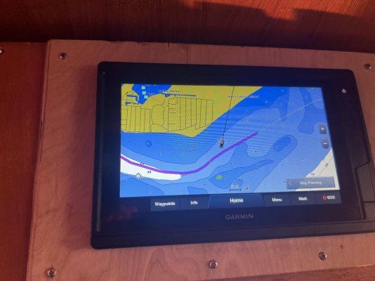
Sorry for your loss of vessel. When I look at my 2018 version of Garmin charts on my chart plotter, there is a dashed magenta line running through the top 8 ft sounding that circles the whole pass area. When I poke it, it comes up”Restricted Area” with 17 pages of chart notes. Curious how the auto route plotted a path through that. My chart also shows 7.9 feet where your boat went aground. It shows a path in with 6.9 feet least depth. Now when I look at the Aqua Maps chart for the same area the bottom contours are clearly different with no clear path in. Hard to know what to believe.
 
I stand corrected as to the heading, as pointed out by paneled, The boat was clearly northbound, not southbound as I initially thought.
 
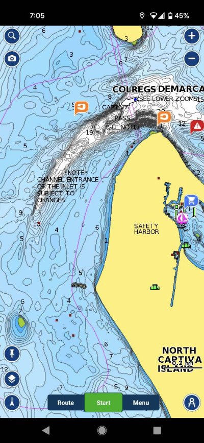
Big difference between Navionics Sonar charts and Garmin. Screenshot_20220330-190508.jpgTrawler%20Forum1175718369.jpg
 
Sad story.

Trying to take some "lessons learned" from this, its possibly a case for forward scan sonar. In those depths it wouldn't give sufficient warning if at any reasonable cruising speed and suddenly there it is, but it might do a better job of giving you a heads up if you find yourself going over 5 and 6 ft spots when you are expecting 8. And do that better than keeping an eye on the depth readout all day long. Just thinking out loud.

Wifey B: And it speaks to local knowledge too. I've not yet ever had a tow by Boat US or Sea Tow and we're members of both, but I and others aboard have talked to their captains many times and often they share knowledge of new shoaling. They know where they've been called for assistance. :)

It's like Romora Bay in the Bahamas. We love the marina and resort. We always get a pilot to guide us. Why? Shifts constantly. I just pulled them up on AC out of curiosity and it reads:

North entrance via Devils Backbone (a pilot is requested).
South entrance via the ocean side (a pilot is requested).​

We have all the tools, all the equipment, and we use it all, but never scared to ask others. :) Also, aware of errors. Right now, Garmin has real issues in the Exumas. When multiple people run aground in the same place, there's a problem. It's like when wrecks happen frequently at an intersection. Something is being done wrong. I think of the short cut around Cape Flattery. We never took it as we just didn't think it was worth the risk. :nonono::nonono:

So, this entrance is a place for every boater in the area to be aware of. I see the shoaling on AC. I read the warnings on Waterway Guide and Cruisers Net. Everything south of Charlotte Harbor is a bit scary. One thing I didn't catch was Good Swan said an overnight passage but doesn't mention the time of running aground. I'd never enter a passage like this at night time. Don't know if he did or not. :nonono:
 
Old timers, commercial fishermen, local fishermen, etc all often use these kinds of inlets.

Until they get their breadcrumb trail or land bearings keeping them in deep water.... they often use the braille method of getting in/out. Not for the faint of heart and it only bases the poking around loosely on charts. Usually done only in the best of weather and the boat type sure helps prevent damage.

If you have the conditions and really, really want to try one of these "local knowledge only" inlets..... it can be done in relative safety but it takes time and patience. The assistance tow captains often have to poke their way into shallows, creeks, bays etc, etc that are not marked and the soundings are horribly wrong. I had what many consider the worst stretch of NJ Intracoastal as my primary response area and had to learn every nook and cranny by the braille method. I spent many a day sliding the keel through mud and cleaning sea strainers ever 30 minutes or so.

Bottom line.... if you don't have protected running gear and or things sticking out of your hull that are fragile...your best bet is to only use marked channels frequented by vessels with deeper draft than you.
 
Last edited:
Digital charts rarely alert you when you're over-zoomed. I can almost guarantee that the two screens shots up-thread (Garmin and Navionics) are over-zoomed which gives a false sense of precision. It's one of the reasons I like Raster charts. Also Coastal Explorer gives a big alert banner when a chart is over-zoomed.

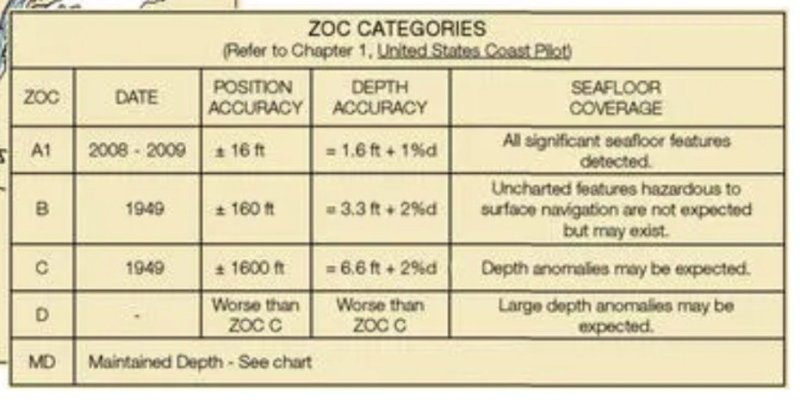
In 2016, NOAA added a ZoC feature to charts. "Zone of Confidence" interprets the accuracy of the underlying data for depth and position (see article below). I think it safe to assume that most waters outside of main channels are "D" worse than every other category.

https://www.passagemaker.com/trawler-news/noaa-introduces-zones-of-confidence-mind-your-zoc

I'd love to be able to say something this awful would never happen to me but I can't. I am decent at visually reading water depths in Florida and am comfortable with over-riding what a chart plotter says the depth should be, but not all angles of the sun or water conditions are conducive. At 72 years old and with a venerable boat, I'd guess the owner is pretty good too. The owner sounds like he took reasonable precautions, at least similar ones I would. But his experience definitely reminds me it's not enough.

I really appreciate these first hand accounts. Very sobering.

Peter 94969326.jpg
 
I can report she is now laying on her side at Gulf Marine Yachtworks in Ft. Myers Beach, FL. I saw her there yesterday and wondered what the backstory was. Very sad sight to see a great cruising boat laid up like that, but glad the crew is safe.
Like many of the passes of SWFL, Captiva Pass is not marked and the shifting sands make them tricky to navigate. Captiva Pass is a bad choice for boats with fixed keels that draw more than two or three feet. For entrance to Pine Island Sound from the Gulf, cruising boats should use Boca Grande Pass, Redfish Pass or come around Pt. Ybel on the southeast end on Sanibel.

Redfish? That private channel heading SE must be better than it looks on my chart; otherwise looks like there’s nowhere to go once you’re inside the islands?

I’ve lived in Sarasota for 30 years now. The only passes I would attempt without perfect weather and lighting, unless I’d just been there in the last couple weeks and had breadcrumbs, would be Tampa Bay, Venice Inlet, Boca Grande, or the S end of Sanibel looks reasonable (never gone out that one). It’s all sand around here, that goes wherever it wants whenever it wants.
 
Pretty much all charted depths, except the recent soundings published by the ACOE after dredging projects or maybe the sonar charts that use crowd sourced data (have no experience with them) are not worth your boat beyond marked, well travelled channels.

Sure they are a starting point...but never be surprised if you are in 5 feet of water when the charts say 20....or vice versa.

Take it from a guy who has regularly gone off the beaten path both recreationally and commercially form Marathon, Fl to Long Island Sound.
 
In 2016, NOAA added a ZoC feature to charts. "Zone of Confidence" interprets the accuracy of the underlying data for depth and position (see article below). I think it safe to assume that most waters outside of main channels are "D" worse than every other category.

https://www.passagemaker.com/trawler-news/noaa-introduces-zones-of-confidence-mind-your-zoc

I'd love to be able to say something this awful would never happen to me but I can't. I am decent at visually reading water depths in Florida and am comfortable with over-riding what a chart plotter says the depth should be, but not all angles of the sun or water conditions are conducive. At 72 years old and with a venerable boat, I'd guess the owner is pretty good too. The owner sounds like he took reasonable precautions, at least similar ones I would. But his experience definitely reminds me it's not enough.

I really appreciate these first hand accounts. Very sobering.

Peter View attachment 127238


Speaking of the Zone of Confidence, I have see those tables on raster charts, but haven't found them in vector charts. Does anyone know how to access them? The info is probably there somewhere, but I haven't been able to find it. It's especially important with the sunsetting of raster charts. There are a few areas in SE Alaska where the soundings are from the late 1800s. It's really good to know when that's the case so you can be extra cautious.
 
Speaking of the Zone of Confidence, I have see those tables on raster charts, but haven't found them in vector charts. Does anyone know how to access them? The info is probably there somewhere, but I haven't been able to find it. It's especially important with the sunsetting of raster charts. There are a few areas in SE Alaska where the soundings are from the late 1800s. It's really good to know when that's the case so you can be extra cautious.
OpenCPN has them buried in the depth information. According to the 2016 PMM article I linked, CE had a similar "quality of measurement" indicator. Would be a good question to pose to the good folks at Rose Point. But I suspect that the vast majority of approach-waters outside of defined channel we traverse are rated at best-guess on whatever scale they use

Peter

PS - below is the relevant text from the PMM article.

The Coastal Explorer NOAA ENC screen above shows how Rose Point is at least showing the "Quality of Sounding Measurement" and Source Date for a spot in the Humboldt channel, though the ZOC data is not shown well in the Zone D area. (Rose Point, incidentally, is also involved in a*NOAA beta test of depth crowdsourcing*that seems promising.)
 
When I look at my 2018 version of Garmin charts on my chart plotter, there is a dashed magenta line running through the top 8 ft sounding... My chart also shows 7.9 feet where your boat went aground. It shows a path in with 6.9 feet least depth. Now when I look at the Aqua Maps chart for the same area the bottom contours are clearly different with no clear path in. Hard to know what to believe.

Your 2018 Garmin charts might be based upon a 2008 survey so your chart plotter isn't necessarily giving you an accurate depth.. GPS is subject to additional errors so you may be 20' - 50' from where the chart plotter thinks you are. (larger waves = larger error.)

Boat manufacturers have a tendency to locate transducers aft. Not the best place. I have mine midship but I know there are no guarantees. I keep my SeaTow membership current.
 
Bottom line.... if you don't have protected running gear and or things sticking out of your hull that are fragile...your best bet is to only use marked channels frequented by vessels with deeper draft than you.

Or if conditions are safe to do so, don't be afraid to anchor the boat, launch the dinghy and go find a safe path through before taking the big boat in. I can think of a few spots where I "should" be able to safely take the boat, but unless following someone of equal draft I'd probably want to see it for myself in the dinghy first.
 
OpenCPN has them buried in the depth information. According to the 2016 PMM article I linked, CE had a similar "quality of measurement" indicator. Would be a good question to pose to the good folks at Rose Point. But I suspect that the vast majority of approach-waters outside of defined channel we traverse are rated at best-guess on whatever scale they use

Peter

PS - below is the relevant text from the PMM article.

The Coastal Explorer NOAA ENC screen above shows how Rose Point is at least showing the "Quality of Sounding Measurement" and Source Date for a spot in the Humboldt channel, though the ZOC data is not shown well in the Zone D area. (Rose Point, incidentally, is also involved in a*NOAA beta test of depth crowdsourcing*that seems promising.)


Thanks. I'll check with Rose Point.


Another important depth quality metric is whether you are seeing spot soundings, or if it's a full bottom scan. With spot soundings, you can only guess what's between the soundings. In some areas the bottom is pretty uniform, but in others there can be very abrupt pinnacles in between the sounding points. Many years ago Bruce Kessler found one I believe in Alaska and it sank his boat.


With a full bottom scan, anomalies like that will have depth soundings. so what you see on the chart is a worst case.


Like with all aids to navigation, it's important to know what it's telling you, and also what it's not telling you.


Oh, and there are a couple of other categories of depth soundings that are worth mentioning while we are on the topic.


I have seen areas where there are spot soundings, and have also been "dragged to xxx depth". I don't know exactly how it's done, but someone here might. But the principal is that a line had been dragged between two ships across the entire area at a depth of xxx, and it didn't snag on anything. So even though you can't confidently know the depths between sounding points, you DO know that it's at least the dragging depth.


The other category everyone is probably already familiar with which is a controlled depth in a maintained channel or waterway. That's where it's dredged and otherwise maintained to at least the controlling depth. You still need to be aware of any changes since such channels still silt back up and need to be re-dredged to maintain their depth, but in theory you have a known minimum depth throughout.
 
Dragged spots are often wrecks where the cable is designed to improve navigational depth over it.

Often it can only take off masts, stacks, small parts of the cabin structure..... but in many cases that could be critical in shallow coastal waters.

By that symbol, you know the exact depth of a wreck (or more.)

Not sure about non wrecks....just that the dragged wire affirms what the sounders show. Dragging a rock pinnacle sounds iffy to me...:D

Looks like divers are used to often confirm the depths if reducing height of an object isn't going to happen.
 
Last edited:
Thanks. I'll check with Rose Point.


Another important depth quality metric is whether you are seeing spot soundings, or if it's a full bottom scan. With spot soundings, you can only guess what's between the soundings. In some areas the bottom is pretty uniform, but in others there can be very abrupt pinnacles in between the sounding points. Many years ago Bruce Kessler found one I believe in Alaska and it sank his boat.


With a full bottom scan, anomalies like that will have depth soundings. so what you see on the chart is a worst case.


Like with all aids to navigation, it's important to know what it's telling you, and also what it's not telling you.

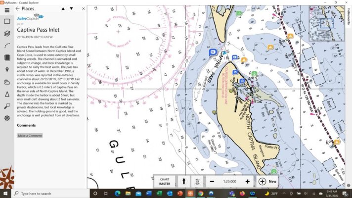
I did some sleuthing on CE and the "Quality of Sounding" shows up as part of the info-pane when you right-click on a sounding (some, not all). On the left-hand reading pane, the range of depth is shown. This thread has been helpful to me as I am still relatively new to Florida boating - stuff really moves around not just in X-Y plane, but in Z-direction too.

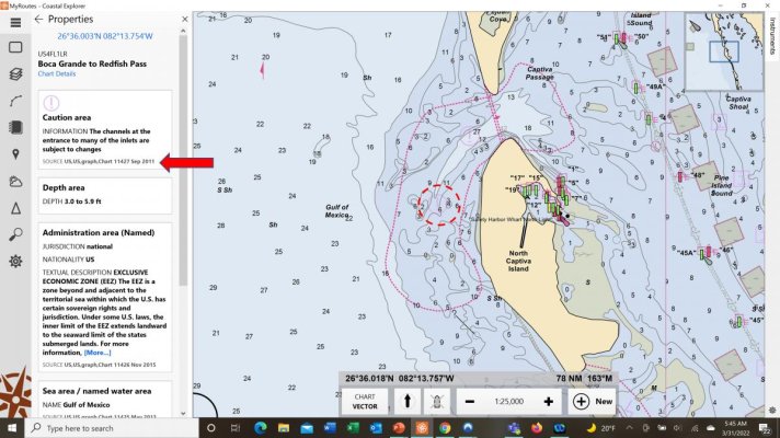
Below are two screen shots of the area where KK went aground - one is Raster, the other ENC. Note how very different the channel looks in each. In the Raster, there appears to actually be a navigable channel, though there is a notation "See Note F." Note F states "The channel is marked by private daybeacons. Controlling depth was 8-feet. Feb 2014." I've included the Active Passage description saying local knowledge is needed.

Now look at the ENC version. Channel appears much different - non-existent. The notes on right margin correspond to approximately where the red-dashed circle is. Source is from 2011!!! Now, you can say crowd-sourced bathymetric data will save the day and perhaps it will. Assuming everyone that runs the inlet has their transducers calibrated - a foot or two makes a big difference here.

Also note, there are NO ATON's. There IS NO CHANNEL HERE except for whatever day-marks locals may have placed and maintained. While not visible on either Raster or ENC, this data is based on 1:40,000 scale. This view is already over-zoomed at 1:25,000 shown at bottom of pane. At 1:15,000, a big caution banner appears at the bottom. This is important as I suspect most people over-zoom their chartplotters which gives a false sense of accuracy. Unless you are in a channel or the data has been validated recently, when you see "6-feet," chances are the actual depth is somewhere between 3-feet and 8-feet.

Here are my learnings from this thread:

1. Heretofor, I favored Raster. There is a ton more info on ENCs. I need to evolve.

2. I rarely read the notes on caution zones because they usually have esoteric information of no relevance to my boat. Usually.....but not always. As the owner of the KK42 painfully demonstrates, failure to do so can have catestrophic effects.

3. Auto-routing is way-cool, but potentially problematic. When I've played with it to give an initial readout of distance, but I had to supress many tags to get it to work in a place like the ICW. This obviously carries potential danger.

4. I continue to like Coastal Explorer. Source data is given.

Peter

Captiva - ENC.jpg

Captiva - RASTER.jpg
 
Dragged spots are often wrecks where the cable is designed to improve navigational depth over it.

Often it can only take off masts, stacks, small parts of the cabin structure..... but in many cases that could be critical in shallow coastal waters.

By that symbol, you know the exact depth of a wreck (or more.)

Not sure about non wrecks....just that the dragged wire affirms what the sounders show. Dragging a rock pinnacle sounds iffy to me...:D

Looks like divers are used to often confirm the depths if reducing height of an object isn't going to happen.


I was not aware of dragging as a way to actively cut down obstacles, but it makes sense in some situations. Where I have seen it on charts is in the PNW where there can, and are, significant and rapid changes in depth. It's common for depths to go from 100s, of not a thousand feet to dry land almost immediately. My assumption has been that the drag wire is a way of verifying that there are no surprises above a certain depth, and a lower tech alternative to a full bottom scan. It's interesting to see it used other ways too.
 
A lot of those inlets on the west coast of Florida are sketchy without local knowledge.

I remember going through New Pass (near Sarasota) one time a couple of days after a storm and having to decide whether to follow
A) the buoys, which didn't look like they were in the channel
B) the chart, which didn't look right, or
C) trusting my eyeballs and where the channel looked like it was.

We were already up on plane, and I was trying to quickly decide if I should stay on plane for a foot less of draft (in a 32 foot twin inboard boat) and risk running up on a sand bar at speed, or slow, down, increase my draft by a foot and risk hitting the bottom where I might have made it if I had stayed on plane.

We stayed on plane, and I followed my gut and what looked like the channel to my mark 1 eyeballs, but it could have easily been me up on a sandbar that day. I'm a lot more choosy about which inlets I will go through on the west coast of Florida these days.
 
I was not aware of dragging as a way to actively cut down obstacles, but it makes sense in some situations. Where I have seen it on charts is in the PNW where there can, and are, significant and rapid changes in depth. It's common for depths to go from 100s, of not a thousand feet to dry land almost immediately. My assumption has been that the drag wire is a way of verifying that there are no surprises above a certain depth, and a lower tech alternative to a full bottom scan. It's interesting to see it used other ways too.

Wire dragging wrecks has been done since WW2 and before. Many of the wrecks from WW2, I took charters to were wire dragged to remove superstructure above the deck. Imagine 2 ships running in parallel with a cable towed between and behind them. It was extremely effective and certainly much quicker than dynamiting the wrecks.

https://njscuba.net/artifacts-shipwrecks/miscellaneous/wire-drag/

Ted
 
Pretty much all charted depths, except the recent soundings published by the ACOE after dredging projects or maybe the sonar charts that use crowd sourced data (have no experience with them) are not worth your boat beyond marked, well travelled channels.

Sure they are a starting point...but never be surprised if you are in 5 feet of water when the charts say 20....or vice versa.

Take it from a guy who has regularly gone off the beaten path both recreationally and commercially form Marathon, Fl to Long Island Sound.

Wifey B: In the famous words of Mulder, "Trust No One." :nonono:

Use every resource possible from various charts (we often have two different systems in use) to local knowledge, to pilot boats, to sonar (this is a place it really can come in handy to slow way down and scan), to checking out in your dinghy (we've done that and mostly just confirms what we thought but sure worth it when we find a surprise in our Rib) to following someone bigger and deeper or observing several. Also, use other resources like Active Captain, Waterway Guide, Cruisers Net and don't forget the CG aids and updates. :)

Then one of hubby's quirky rules, "When in Doubt, Don't." :nonono: Take the safer, longer route, or wait until tide change and daylight or gather more information. We talk of schedules being dangerous as in days of time, but it's not just big increments of time, hours and minutes can be. If we're tired (as I suspect the Swan Man was) or feel rushed. Sit back, relax, think. Might save you a lot of trouble. :)

Now the best lesson perhaps still is insurance and safety protocols and get away safely and leave the boat to someone else, but if you do this long enough, something will happen one day and then the only really important thing is to escape with your life, without serious injury, and live to do it again sometime. :)
 
Use every resource possible from various charts (we often have two different systems in use)

My dearly departed father was fond of saying "a man with a clock always knows the time. A man with two clocks is never sure." Certainly helpful to highlight disparity. Not sure what you do about reconciliation.....

WifeyB - everything on your list would definitely reduce risk. But can take a lot of time and distract from actually looking out the window, which for some reason is a neglected tool these days. Somewhere deep in the tap root here is a mindset shift into cruising. Everyone knows they should anchor or divert unless conditions are right. But how many have the discipline to wave-off getting back to their dock Sunday afternoon when work beckons Monday morning?

I struggle on threads like these. I think it tempting to say I'd never ground on a shoal like the KK42 did. And I probably won't because it's fairly rare and law of numbers is on my side. But given I assume a 72-year old owner of a KK42 is experienced and skilled, I gotta ask myself how can I change my fate beyond the obvious? Suppose he read the same playbook we all espouse about taking precautions

How do any of know we're doing it right versus just haven't encountered bad luck?

Peter
 
Last edited:
As I said, never want to ground a 4-5 foot draft boat?.... stick with shipping channels or those USCG marked ones used by much larger than yours.

Think like a ship, drive like a ship never deviate.
 
Last edited:
I’m always way too scared to try any inlet or channel that says “local knowledge required”. I generally have zero local knowledge when cruising.

Heck, I have very little non-local knowledge as well, come to think of it. ?
 
The big difference for me is USCG marked inlets and those that are not.

Some (maybe many) are USCG marked inlets, but the buoys are not charted as noted on the charts.

I know a few of these inlets are marked local knowledge or described that way in waterway guides and internet lore. Having run them in good to moderate weather...they are very easy as long as you get the general pattern/location of the buoys from an assistance tower or just follow someone to the sea buoy and from there observe the general direction the vessel heads.

Sometimes because of a bridge or shoal and strong currents the can be tough on one tidal flow but a breeze on the other. Probably why the "local knowledge" label, but a one minute phone call might clear that all up.

Sure, if uncomfortable don't do it, but after trying some I was surprised at how relatively easy they were once you could eyeball much of the inlet and traffic as well as the USCG marks.

I am not saying be adventuresome, just be a prudent mariner and add a new inlet to your list as a possibility...just remember to check it by phone before you try it if it has been a while.
 
Digital charts rarely alert you when you're over-zoomed. I can almost guarantee that the two screens shots up-thread (Garmin and Navionics) are over-zoomed which gives a false sense of precision. It's one of the reasons I like Raster charts. Also Coastal Explorer gives a big alert banner when a chart is over-zoomed.

In 2016, NOAA added a ZoC feature to charts. "Zone of Confidence" interprets the accuracy of the underlying data for depth and position (see article below). I think it safe to assume that most waters outside of main channels are "D" worse than every other category.

https://www.passagemaker.com/trawler-news/noaa-introduces-zones-of-confidence-mind-your-zoc

I'd love to be able to say something this awful would never happen to me but I can't. I am decent at visually reading water depths in Florida and am comfortable with over-riding what a chart plotter says the depth should be, but not all angles of the sun or water conditions are conducive. At 72 years old and with a venerable boat, I'd guess the owner is pretty good too. The owner sounds like he took reasonable precautions, at least similar ones I would. But his experience definitely reminds me it's not enough.

I really appreciate these first hand accounts. Very sobering.

Peter View attachment 127238
Agree, that is why I run a split screen with one chat at 1.5 - 3 miles and the other zoomed in as far as it goes. Early in trawler boating I bit the bottom because I was zoomed out.
I am a big fan of Navionics Sonar charts. Put them side by side with government charts and the detail is much better.
 
Back
Top Bottom