Starlink RV is now Starlink Roam

The friendliest place on the web for anyone who enjoys boating.
If you have answers, please help by responding to the unanswered posts.
I have had my Starlink roam set up and running at home for the past month. Now it is moving on board. Looking forward to going to dead zones for cell service in the gulf islands.
Not concerned about in motion service, if it works great, if not I am busy driving and enjoying the scenery.
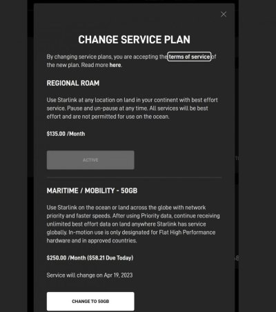
$412 CAN$ invested in hardware, pay by the month $190 with taxes during months of actual need. No cost in off season. Priceless. :dance:

I hope that you are correct, but Musk is geofencing and segmenting the market, so that may no longer be true. What worked last season (and for me) may well not work this season.
 
I hope that you are correct, but Musk is geofencing and segmenting the market, so that may no longer be true. What worked last season (and for me) may well not work this season.
I doubt they will geofence within 3 miles from land, probably not within 10, that would be pinpoint targeting efforts. Open ocean, of course.
Juan de Fuca why would they bother creating a dead zone down the middle. Pointless. The inside waterway of Salish sea will work with roam.
 
If people are happy using some other system they want to stay with why do they read the SL threads???????????????

I think I will ask on the Facebook "Two cans and a string for communication" page. There are probably people on that posting how banging rocks with sticks is working fine for them.
 
If people are happy using some other system they want to stay with why do they read the SL threads???????????????

I think I will ask on the Facebook "Two cans and a string for communication" page. There are probably people on that posting how banging rocks with sticks is working fine for them.
I don't have any connectivity while out cruising except my cell phone....am I allowed to read this thread to see if there is a better alternative?:rofl::)
 
I doubt they will geofence within 3 miles from land, probably not within 10, that would be pinpoint targeting efforts. Open ocean, of course.
Juan de Fuca why would they bother creating a dead zone down the middle. Pointless. The inside waterway of Salish sea will work with roam.

Agree. I understand geofencing to refer to differentiating between users based on their reported GPS locations. It's clear that's not what they are doing right now, and I'd be surprised if they went down that route in the future, at least with the kind of precision that could distinguish between land-based and marine users in inside waters.

What they are doing is differentiating between users with different subscription types based on the coverage cell that is physically providing them with service. This is much simpler to implement and still allows them to provide a variety of service tiers at different price points to offshore vs. inshore users.
 
One has to wonder the meaning of the word "ocean."

If the dish has to use a newer satellite to communicate with another, to access a station on the ground to get to the Internet, is that considered "ocean" vs a dish that only has to go up to one satellite to get back to ground and thus the Internet?

Not sure when it happened, but my Starlink dish is now pointed east instead of north. This is supposed to have happened to some users on the east coast of the US to access satellites that are not as busy as the satellites over land. It appears we know have fast access speeds, which is not say we had slow speed before, it the speed tests seem to be a bit faster. We are a good distance from the coast.

Later,
Dan
 
Zoom in on a coverage map and you will see 6 sided coverage bubbles. In order for the guy with a beach house to get coverage these extend miles into the water. When I asked the question, that is what I was told to do to see if I have water coverage.
 
Zoom in on a coverage map and you will see 6 sided coverage bubbles. In order for the guy with a beach house to get coverage these extend miles into the water. When I asked the question, that is what I was told to do to see if I have water coverage.


That’s the obviously true answer that I just couldn’t get the customer support rep I asked to give me straight up.

I’m going to stick with standard roam for this summer in the inside passage. But it’s nice to have the option of switching to a prioritized data plan for $250/mo for cruising in populated areas or offshore, as long as you can stay and stop and go back and forth.
 
Zoom in on a coverage map and you will see 6 sided coverage bubbles. In order for the guy with a beach house to get coverage these extend miles into the water. When I asked the question, that is what I was told to do to see if I have water coverage.

I have seen that map, and others, but we know people in boats are accessing Starlink at sea and outside of the coverage areas on the maps. Shocking that some of the boats have actually had coverage in the middle of the Pacific.

Later,
Dan
 
I have seen that map, and others, but we know people in boats are accessing Starlink at sea and outside of the coverage areas on the maps. Shocking that some of the boats have actually had coverage in the middle of the Pacific.

Later,
Dan
And why not, the signal is out there and not a lot of traffic with basic dish. What a bother to make sure a lone traveler who does not have the premium package gets blocked. Doable, but why bother.
 
I doubt they will geofence within 3 miles from land, probably not within 10, that would be pinpoint targeting efforts. Open ocean, of course.
Juan de Fuca why would they bother creating a dead zone down the middle. Pointless. The inside waterway of Salish sea will work with roam.

I hope that you are right. Why would they bother? Because they know mariners alternatives are much more expensive and less adequate.

Scooter rental companies geofence no go areas with a street as a boundary so it’s not a technological issue.

I’m cynical since he arbitrarily changed key terms to my detriment as an early Tesla adopter, where he lied with no recourse, or in lesser cases just took advantage of ambiguity to make it more costly.

I put starlink on my boat last spring and already we have seen changes for the worse. It’s still the best alternative but I just assume it will be changed for the worse.
 
Switch over to the new plan was not available yesterday afternoon when the email went out. It apparently is today.

I have the HP Flat, but no plans to switching over to the maritime plan as long as they allow useage along the coast.
 

Attachments

  • Screenshot 2023-04-19 at 2.52.24 PM.jpg
    Screenshot 2023-04-19 at 2.52.24 PM.jpg
    88.6 KB · Views: 47
From another website. It appears toggling between the two plans is allowable.
 

Attachments

  • Screenshot 2023-04-19 at 3.02.11 PM.jpg
    Screenshot 2023-04-19 at 3.02.11 PM.jpg
    68 KB · Views: 46
Last edited:
But that's not the official coverage map
This is
https://www.starlink.com/map

Add: that link SteveK put up is way wrong.
It shows vaste sections of Australia with no hexagons at all whereas it does actually have full coverage according to the official map and, reports from users.
OK, compare it to the one on the Starlink site then. Really hard to see, you have to zoom in close to get locations to show up.
 
OK, compare it to the one on the Starlink site then. Really hard to see, you have to zoom in close to get locations to show up.

I only need to zoom in this far to see ALL of Aus is done ;)
 

Attachments

  • Screenshot_2023-04-20-09-30-20-317_com.android.chrome.jpg
    Screenshot_2023-04-20-09-30-20-317_com.android.chrome.jpg
    39.2 KB · Views: 36
My SL has worked great for 4 months now in Bahamas and the map of service says Bahamas is "coming soon". I have the $135/mo RV kit because that was available when I ordered from Jacksonville Fl because Jacksonville is "wait list" otherwise. I just got my invoice for Apr 27 and it is still $135 even though I got email couple months ago saying it was going up to $150. I just checked my account page and it says I am not on the Roam plan, but still says $135.

Because I changed my cell phone to a cheap prepaid carrier when I got the SL, it is costing me $40/mo more when in US for SL+cell and $50/mo LESS while in Bahamas.

Service has sooooo much better in Bahamas with SL than with the cell mifi I used last 2 trips.
 
Starlink can be so good. Game changing.

I’d pay $350 / month (probably more) for uncapped data (or at least enough to use for tv and movies) with priority data speeds and in motion service for coastal cruising and up to 5nm or 10nm off shore in ocean. Especially if I could suspend service. Inexpensive and much better than VSAT and if out of range of cellular. It’s the confusing and sudden change of terms between equipment required (once invested), where the coverage extends to, data caps, lowest priority speed that make it hard.

It’s been basically a year for me with Starlink and I’m on my third plan…with some no longer existing. It’s not all their fault though as we probably used it initially for an unintended market.
 
Last edited:
I have both a US based starlink account and a account based in Mexico.

On my US account is was "regional roam" and I converted it yesterday to "maritime"

My opinion is that eventually probably sooner than later starlink will geofence fairly accurately. The starlink alrerady has a GPS onboard. Comparing your location against a map would not be all that difficult I think.

Realistically I see 50 GB as just fine. I am not a streamer of video, but I do want coverage away from port

Here is a screen shot of how to change your plan
 

Attachments

  • F2BCA27D-EFF4-4F9A-BAB2-FEB513AD1D2E.jpg
    F2BCA27D-EFF4-4F9A-BAB2-FEB513AD1D2E.jpg
    59.9 KB · Views: 38
Is the new maritime plan allowed to be suspended like the RV plan? It wasn’t specified in the email they sent me. Nor the additional charge for extra GB.
 
Kevin, why did you make the change, I thought it was working for you as is.

It was, my thought is that if they areoffering the maritime service, they will start geofencing.
 
I have both a US based starlink account and a account based in Mexico.

On my US account is was "regional roam" and I converted it yesterday to "maritime"

My opinion is that eventually probably sooner than later starlink will geofence fairly accurately. The starlink alrerady has a GPS onboard. Comparing your location against a map would not be all that difficult I think.

Realistically I see 50 GB as just fine. I am not a streamer of video, but I do want coverage away from port

Here is a screen shot of how to change your plan

The account you converted to maritime has a Flat/HP dish; correct?
 
I have been sitting on the sideline watching all this development. I guess I will wait until fall to make a decision. Hopefully things will settle down.

So far we have KVH and AT&T Hotspot. Works well when need population center. We use DirectTv. So really no issues with what we use.

Wait and see.
 
I'm certainly glad we have it at present.

We are currently stuck 50nm out in a coral lagoon with 30+ of wind and more for at least another week.
Due to height or lack of, we are getting patchy at best VHF, zero phone but SL beaming the weather and comms in when required.

Been stuck out here on previous boats we've had.
They had masts so VHF was better, but you'd only know what to expect 3 days out and of course, no opportunities to look at any weather charts.
No where near as comfortable or we'll provisioned either.
 
I have been sitting on the sideline watching all this development. I guess I will wait until fall to make a decision. Hopefully things will settle down.

So far we have KVH and AT&T Hotspot. Works well when need population center. We use DirectTv. So really no issues with what we use.

Wait and see.

I'm in that same situation. Our current connectivity has been adequate. I'd like to add Starlink to the mix, but we don't need it enough to rush. Better to wait until the offerings are a bit more stable / predictable and then go for it.
 
Back
Top Bottom