Hurricane Ian was Tropical Storm Ian was Tropical Depression 09

The friendliest place on the web for anyone who enjoys boating.
If you have answers, please help by responding to the unanswered posts.
Naples at 1:24 today posted by the City Police.
 

Attachments

  • 21585E14-CE27-4F52-9B22-5802E9E5010E.jpg
    21585E14-CE27-4F52-9B22-5802E9E5010E.jpg
    151.3 KB · Views: 60
So we put the shutters up on the house in Ft. Myers Saturday which now seems like a good thing. We moved to the boat in Jacksonville which now seems like a bad thing...

Moving to a hotel later today to ride it out. Hopefully we have one or the other to go back to after the storm! Take care everyone in Florida!


Spike, stay away from big glass windows.

One bad thing about riding it out in a hotel, they have lots of expensive food for you to buy. :D
 
The Weather Channel had a shot of a marina in Tampa somewhere and all the boats were sitting on the bottom since all the water had been drawn out. Didn’t get the name of the marina, wouldn’t have meant anything to me since I am not familiar with the area.
 
That's just ridiculous! Whoever made that storm surge map for the area Englewood to Bonita Beach needs to be drug tested or fired for incompetence.

When the water reaches 10', there will probably be close to a thousand square miles inside the barrier islands, covered with water. Between the speed the hurricane is traveling to land, the shallowness of the coastal water to 10 miles off shore, and the low level of land and existing estuaries, 12 to 16' is total BS. Can they not see people will question their credibility next time?

Ted

Are you still thinking they were so far off on their estimations?
 
Last edited:
Are you still thinking they were so far off on their estimations?

All the pictures I've seen so far of Fort Myers don't show anything close to 12'. No doubt the wind was bad, but not seeing any buildings so far where the first story is completely under water.

Ted
 
Gauge between the bridges at Ft. Meyers Yacht Basin:
 

Attachments

  • DEEE6D54-5573-4B7C-85FF-93F1E31803F0.jpg
    DEEE6D54-5573-4B7C-85FF-93F1E31803F0.jpg
    80.9 KB · Views: 53
The Weather Channel was reporting 10’+ surge in places.
 
Hi Ted:

Native Floridian here. I've lived through a few hurricanes. But even I had to have the craziest part of hurricane storm surge explained to me by a meteorologist.

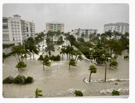
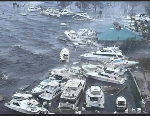
You probably saw several accounts of Sarasota bay and Tampa Bay "emptying out" today. Anyone can look at the counterclockwise rotation of hurricane winds imposed over a map, and see how the water from the NORTH side of the storm was pushed by the wind, around the storm, and then deposited on the land areas on the SOUTH side of the storm, i.e. the Ft. Myers area.


But that's not all there is to storm surge. There is a most interesting phenomenon associated with hurricanes:

Inside the eye, the barometric pressure is the lowest. The water rises up inside the eye as the hurricane approaches the coast.

Depending upon several variables, the water inside the eye of a Cat 4 can be as much as 30 feet higher than the water outside the eye (before the eye hits a land mass).


So when the eye of a storm passes over land, it brings the "higher eye water" along with it.


Once the eye breaches land, the eye wall begins to break down because the eye no longer has water beneath it (this is simplifying things, but I don't need to discuss all the physics). The "higher eye water" starts to "leak" out.


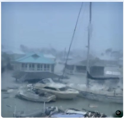
I was watching an unmanned camera on Sanibel Island today that was mounted high up on the second floor balcony of a condo.


When the camera became submerged, I knew then that the eye wall had hit Sanibel.


And you are correct that once the water is released from within the eye, it will naturally "level out." Like when you spill a glass of liquid on your countertop, it moves immediately to the lowest edge and runs on to the floor.


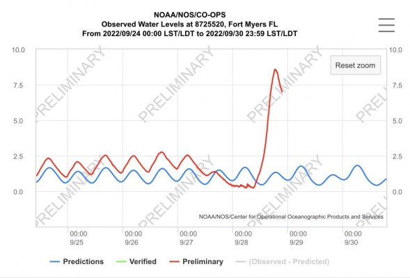
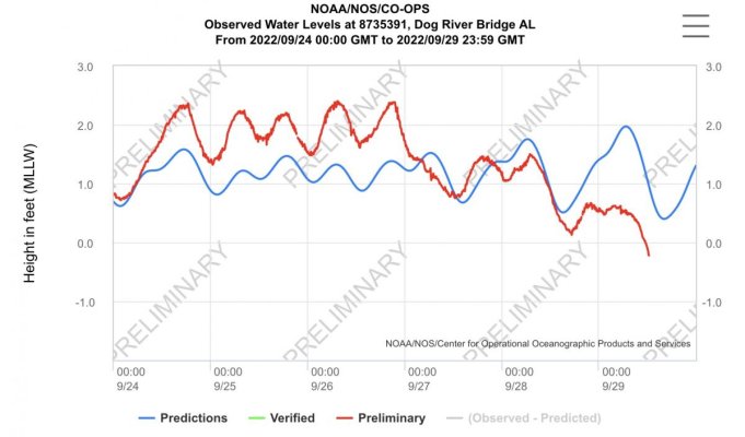
This "higher water inside the eye" is the reason why tide gauges can measure a storm surge of 13 feet in one location, yet a gauge location only, say, ten miles north of the first one, measures just 4 feet of storm surge.


Both gauges are accurate. The northern gauge wasn't located in a place where the eye passed over it, or the eye wall had already started to break down by then.


This is why Sanibel can be hit with a 20 ft storm surge, but Cape Coral may only experience a 5 ft storm surge minutes later.


This is why barrier islands like Sanibel act as "barriers" to storm surge. (In fact, it's why they are called "barrier islands.") A hurricane's eye begins to break down when it passes over a barrier island, and the water contained within the eye starts to "leak out."


There are several other factors that can contribute to storm surge, such as the shallower water close to the coast, but you get the idea.


Photos from Sanibel Island when the sun comes up will certainly be interesting.


Warm Regards,
Mrs. Trombley


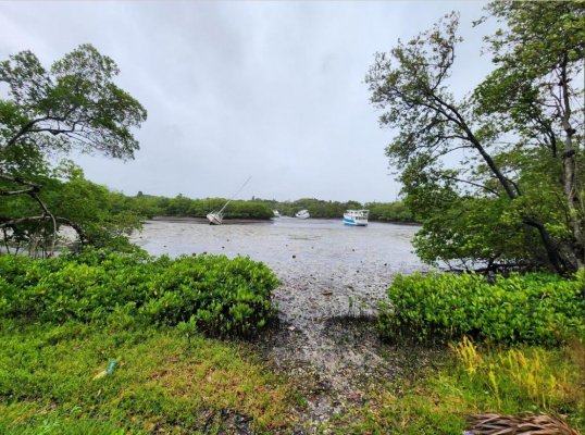
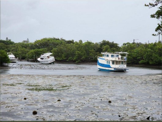
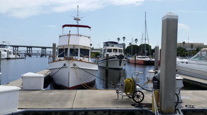
Here are a couple of photos of boats aground in hurricane holes on Tampa Bay that I found on the twitter:
 

Attachments

  • 2022-09-28 _Hurr Ian Tpa Bay 1.jpg
    2022-09-28 _Hurr Ian Tpa Bay 1.jpg
    197 KB · Views: 53
  • 2022-09-28 _Hurr Ian Tpa Bay empties out.jpg
    2022-09-28 _Hurr Ian Tpa Bay empties out.jpg
    153.2 KB · Views: 68
Last edited:
Nice explanation, Miz Trom!
 
From another forum, a picture of "Legacy" (Legacy Harbour?) in Ft. Myers.

The other pic is just behind us, at just under high tide, when we were at Legacy Harbour last June/July '21.

I don't know how high the piles were, but it looks like not high enough...

-Chris
 

Attachments

  • legacy.jpeg
    legacy.jpeg
    187.6 KB · Views: 58
  • snapshot1.jpg
    snapshot1.jpg
    96.4 KB · Views: 42
"Storm surge is caused primarily by
the strong winds in a hurricane or
tropical storm. The low pressure of
the storm has minimal contribution!"


The above is from the National Hurricane Center brochure on storm surge. Unfortunately have lost link to pdf file. Another reason storm surge waries greatly in short distances is bottom slope....just like in tsunamis.

Low air pressure also plays a role.
At the center of a hurricane, air pressure is low. Low air pressure causes a slight bulge in the ocean, which adds to the mound of water that causes storm surge. Most of the water is piled up by wind, but about 5% of the mound is due to low air pressure.

Hurricanes are a whole professional study by themselves and in my experience, most people pass along a incorrect technical info, even if their lifetime of hurricane survival skills are pretty good.
 
Last edited:
For some reason, surge has only recently been talked about with hurricanes. The NHC warnings and predictions like “peak surge” are fairly recent. Part of the reason for that, I believe, is that it is still an evolving study.

In Katrina, for example, we have plenty of forensic and photographic evidence of how high the surge got in different locations and it often makes no logical sense that I can figure out.

I do believe the topography of the ocean bottom is a major factor in how high the surge will get. It is an interesting thing to ride from Ocean Springs, to Waveland, Mississippi and see the actual surge heights in places that have memorialized them. (Much to the displeasure of local realtors!).
 
"Storm surge is caused primarily by
the strong winds in a hurricane or
tropical storm. The low pressure of
the storm has minimal contribution!"


The above is from the National Hurricane Center brochure on storm surge. Unfortunately have lost link to pdf file. Another reason storm surge waries greatly in short distances is bottom slope....just like in tsunamis.

Low air pressure also plays a role.
At the center of a hurricane, air pressure is low. Low air pressure causes a slight bulge in the ocean, which adds to the mound of water that causes storm surge. Most of the water is piled up by wind, but about 5% of the mound is due to low air pressure.

Hurricanes are a whole professional study by themselves and in my experience, most people pass along a incorrect technical info, even if their lifetime of hurricane survival skills are pretty good.

"most people pass along a incorrect technical info"

Definitely an accurate statement. For those that wish to get into much more detail and/or play with an interactive surge model here is a link...

https://www.nhc.noaa.gov/nationalsurge/?text
 
Greetings,
Mr. DC. Are the water level numbers in feet or meters?

Apologies Mr. Firefly. NOAA gauge data is in feet above MLLW. Here’s one from Mobile Bay, about half the size of Tampa Bay, relatively shallow and about 400 miles from Ian’s landfall. Ian has generated several days of 15-25 kn winds along the northern gulf coast which blew several feet of water out of the bay. Big storm!
 

Attachments

  • DEAB769A-8F51-43FF-A045-A4CF7DDB7983.jpg
    DEAB769A-8F51-43FF-A045-A4CF7DDB7983.jpg
    71.3 KB · Views: 32
https://scied.ucar.edu/learning-zone/storms/what-causes-storm-surge

"Low air pressure also plays a role.
At the center of a hurricane, air pressure is low. Low air pressure causes a slight bulge in the ocean, which adds to the mound of water that causes storm surge. Most of the water is piled up by wind, but about 5% of the mound is due to low air pressure."

Lake St Claire is another example of water piling up on either the Canadian or US side depending upon the wind intensity and direction.
 
Last edited:

Latest posts

Back
Top Bottom