Dorian aims for East Coast of Florida

The friendliest place on the web for anyone who enjoys boating.
If you have answers, please help by responding to the unanswered posts.
Hope Town Sailing Club web site pulling all of the photos and reports together. It's a lot jumbled but seems to be chronological order, latest to oldest, as they get things in.

https://www.hopetownsailingclub.com/
 
Last edited:
Strange how info is coming out of most islands, but mot much of anything out of GTC yet. I guess it’s not quite as populated as the others?
 
Strange how info is coming out of most islands, but mot much of anything out of GTC yet. I guess it’s not quite as populated as the others?

Only thing I am seeing is no loss of life - even with the primary school shelter failing.
 
Ok. Thanks for the info. Please let me know if you see anything new. I’m talking to the insurance adjuster today and he’s asking what the damage is to my boat. They said this will be a long process.

Hope this storm doesn’t whack you too bad up there in Jacksonville. Will it be more of a flooding event and not so much wind?
 
Can't see the wind exceeding 50kts, but who knows. Yes, it will be more the surge. High tide is a 2:53pm and it is a king tide unfortunately.
 
The 11am Update. It is now heading 335. Enough that NE Florida has been downgraded to TS Warning from Hurricane Warning. So just surge and flooding to worry about. Carolinas still in play though.

The initial motion is now 335/8. Dorian is moving around the
western end of the subtropical ridge, and it should recurve
northward and northeastward into the mid-latitude westerlies during
the next 24-48 h. This motion should bring the center of Dorian
near or over the coast of North Carolina during the 36-48 h period.
After that time, the cyclone is forecast to accelerate northeastward
into the Atlantic toward the Canadian Maritimes, with a quick
northeastward motion continuing for the remainder of the cyclone's
life. The track guidance is very tightly clustered, and the new
forecast track, which has only minor changes from the previous
forecast, lies in the center of the guidance envelope near the
consensus models. It should be noted that the track is close to and
almost parallel to the coast of the southeastern United State, and
any deviation to the left of the track could bring the center
onshore anywhere in the Carolinas.
 
Last edited:
Only thing I am seeing is no loss of life - even with the primary school shelter failing.

Just because you're not seeing loss of life, doesn't mean it isn't there. Hundreds of people not located and reports from those on site are of significant loss of life, beyond the official reports. Only time will tell.
 
SC and NC may get near record surge. This is on top of rain and already saturated ground.
 
Just because you're not seeing loss of life, doesn't mean it isn't there. Hundreds of people not located and reports from those on site are of significant loss of life, beyond the official reports. Only time will tell.

Unfortunately, very true. I believe there are still sixty two unaccounted for individuals in Mississippi from Katrina. Most are presumed to have been sucked out to sea when the surge subsided, or hauled off with debris( the smell of death will be everywhere so it’s hard to find some bodies). One individual (or what was left of him) was found hanging in a tree five or six years later.

I pray the death toll doesn’t go higher, but I expect it will.
 
Last edited:
Just because you're not seeing loss of life, doesn't mean it isn't there. Hundreds of people not located and reports from those on site are of significant loss of life, beyond the official reports. Only time will tell.

CarDude and I were specifically discussing Green Turtle Cay. Satellite phone reports out of there are that everyone has been accounted for. Easier to manage than say Marsh or even Hope Town, given the small population and gathered to one or two locations.

Still they could have missed someone.
 
CarDude and I were specifically discussing Green Turtle Cay. Satellite phone reports out of there are that everyone has been accounted for. Easier to manage than say, Marsh, given the small population and gathered to one or two locations.

Still they could have missed someone.

Very true. I just hate to see thing like the government saying 5 deaths or now 7 when the reality is they have no idea yet. May be none or virtually none in GTC.
 
Very true. I just hate to see thing like the government saying 5 deaths or now 7 when the reality is they have no idea yet. May be none or virtually none in GTC.

I guess they can be very accurate when they use the term "confirmed deaths." That would be when seen and documented by a medical professional.

Same here I would guess, certainly is in the UK. When my father passed two years ago he went just before midnight. We called for the doctor who showed up around 5:30am. The death certificate was issued for the date the doctor confirmed it. I went back and had them change it to when he actually passed.
 
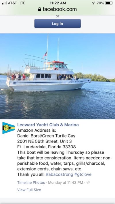
I’m seeing some reports that two boats are supposedly heading over to GTC Friday or Saturday. They are taking food, water and other supplies. One is a steel hulled boat, and the other is a Contender 30.

Is it safe to head over there by boat already? I would really wonder about getting into Black or White Sound after this storm. It was pretty skinny water getting in there before, and it seems like it could be clogged with debris now?

This is steel boat:
IMG_6807.JPG
 
Last edited:
I’m seeing some reports that two boats are supposedly heading over the GTC Friday or Saturday. They are taking food, water and other supplies.

Is it safe to head over there by boat already?

No! And authorities have told people to stay away. If they hole their boat on just-under-the-surface debris who do they think is coming to help them?

Are these boats leaving from the US - or from elsewhere in Abaco?
 
Leaving from Dania/Fort Lauderdale.
 
https://oceanservice.noaa.gov/facts/springtide.html


A spring tide—popularly known as a "King Tide"—refers to the 'springing forth' of the tide during new and full moon.
A neap tide—seven days after a spring tide—refers to a period of moderate tides when the sun and moon are at right angles to each other.


Popular because the only weather most people know is the trash on TV.


Been called spring tides for hundreds of years...this is the first season I think I have heard King Tide.


Boaters calling them King Tides ought to wince when they say it. :facepalm::D:D
 
Leaving from Dania/Fort Lauderdale.

Wonder if there will be anyone out there stopping boats from crossing?

Regardless, if you are thinking about it I would hold off.
 
Last edited:
https://oceanservice.noaa.gov/facts/springtide.html


A spring tide—popularly known as a "King Tide"—refers to the 'springing forth' of the tide during new and full moon.
A neap tide—seven days after a spring tide—refers to a period of moderate tides when the sun and moon are at right angles to each other.


Popular because the only weather most people know is the trash on TV.


Been called spring tides for hundreds of years...this is the first season I think I have heard King Tide.


Boaters calling them King Tides ought to wince when they say it. :facepalm::D:D

You should start another thread about how much you can Google. This thread is about a hurricane that is currently threatening the SE coast and has taken many lives in the Bahamas.
 
Wonder if there will be anyone out there stopping boats from crossing?

Regardless, if you are thinking about it I would hold off.


I briefly thought about trying to get a ride over there, but seems too risky and no place to stay once there. I’m too old for that level of roughing it.
 
Wonder if there will be anyone out there stopping boats from crossing?

Regardless, if you are thinking about it I would hold off.

Wonder if they'll properly clear in through customs.

There are well organized rescue organizations already with activities underway. There are 25 containers on a barge leaving from Miami through Global Empowerment Mission. Bahama Strong has an event today at Bayside and 19 locations for donating needed items.

http://yachtaidglobal.org/ has vessel "Loon" already on the way and they're quite experienced at projects like this.

As much as many of us long to head over right now and help, we don't know how to do this and we're just more amateurs in the way. Hook up with an organization that knows how to get the aid to the people.

Also, don't forget them. There will be more hurricanes this year but don't forget the northern Bahamas still in need after others are as well. Get them help today through organizations skilled in providing it. Three months from now, go help them yourselves if things are set up to allow it by then, or, if not, six months from now.
 
You should start another thread about how much you can Google. This thread is about a hurricane that is currently threatening the SE coast and has taken many lives in the Bahamas.
Let's get one thing staright....


I am still in line to get slammed by Dorien if surge stays as predicted.


When it turns out to be a common term that has been changed because boaters learn from TV now ...yeah....googling was a waste of my time and so is this answer.

My comments are still about an active hurricane...comments on already affected areas could be moved to a new thread.
 
Last edited:
Plus who do they give the supplies to? The first person who shows up? What if they fight over the generator, water and food you take over - or worse.

Abaconians are awfully wonderful people, they really are. But they are in a really bad place right now.
 
1:00 update. Still not turned to the north. Due east of St Augustine now.

Latest radar. With its shape it is impacting Hilton Head before JAX!

https://www.weather.gov/jax/

A WeatherFlow station in Jacksonville recently reported sustained
winds of 43 mph (69 km/h) with a gust to 55 mph (88 km/h).

An Air Force Reserve Hurricane Hunter aircraft recently reported a
minimum central pressure of 963 mb (28.44 inches).

SUMMARY OF 100 PM EDT...1700 UTC...INFORMATION
----------------------------------------------
LOCATION...30.1N 79.7W
ABOUT 100 MI...160 KM NE OF DAYTONA BEACH FLORIDA
ABOUT 190 MI...305 KM S OF CHARLESTON SOUTH CAROLINA
MAXIMUM SUSTAINED WINDS...105 MPH...165 KM/H
PRESENT MOVEMENT...NNW OR 335 DEGREES AT 9 MPH...15 KM/H
MINIMUM CENTRAL PRESSURE...963 MB...28.44 INCHES
 
Last edited:
I was told that instead of trying to take supplies over on my boat or sending supplies on another boat it would be better to donate money and let the professionals purchase what is needed at this moment and let them off load those supplies and keep them safe from the elements and unscrupulous people. I donated money and continues do so.
 
Logistics handling after an event like this has to be coordinated... Remember all the "relief" supplies and aid rotting on the docks in Haiti?....well intentioned peeps have to coordinate with authorities..
 
Logistics handling after an event like this has to be coordinated... Remember all the "relief" supplies and aid rotting on the docks in Haiti?....well intentioned peeps have to coordinate with authorities..

I saw in Freeport someone had commandeered some major construction equipment and was riding through the water in the roads, looking for people and helping others. That's the type equipment that will be needed to clear roads, to take care of debris, to carry supplies and people.

The other things most needed will be some forms of temporary shelter and food and medicine.
 
I briefly thought about trying to get a ride over there, but seems too risky and no place to stay once there. I’m too old for that level of roughing it.

One star camping would be about the best you could hope for, based on my experience. I remember being given an air mattress about week two and it was like I had been given a room in the Waldorf Astoria!
 
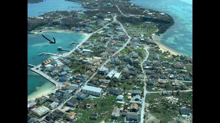
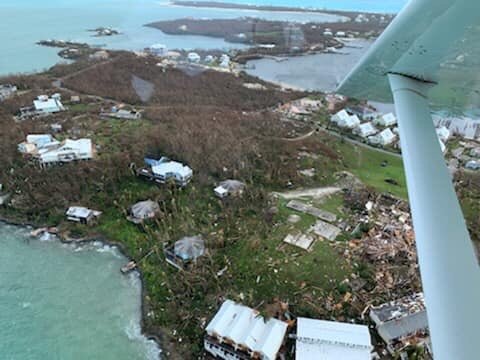
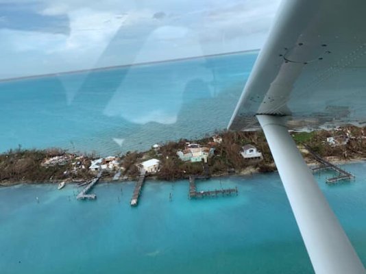
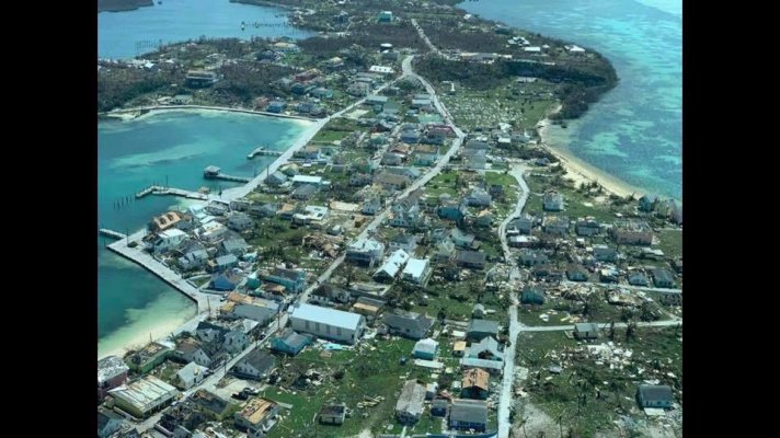
Some pics of GTC finally.

New Plymouth still has some buildings standing , and the ferry dock and other private docks still standing . That’s kind of surprising compared to the devastation of the other islands.

New Plymouth. Ferry dock with roof still standing (arrow)
IMG_6808.JPG


Bluff House in background, under the wing.
IMG_6811.JPG


Entrance to White Sound I think
IMG_6810.JPG
 

Attachments

  • IMG_6808.JPG
    IMG_6808.JPG
    187 KB · Views: 55
Last edited:
Where was your boat - Black Sound?
 
Its 115 miles due east of us now. We have a breeze and some rain, but very very minimal.

We are very thankful.
 
Back
Top Bottom