Current border closure aside, is there a procedure for cross border reporting to CBP/CBSA on the Columbia River between BC and WA or is it simply a no go?
https://goo.gl/maps/RXDkBFT8mDicEJt26
https://goo.gl/maps/RXDkBFT8mDicEJt26
Not looking at Astoria to the icefields, just the 20 miles or so between Trail BC and Northport WA.Is it navigable that far up? If so, how?
You're just playing with me aren't you?Oregon and Washington are states.
Not looking at Astoria to the icefields, just the 20 miles or so between Trail BC and Northport WA.
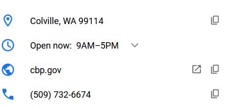
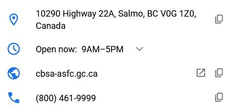
There doesn't seem to be a "them" so I assume the two "customs houses" are not regularly staffed; there is no contact information for either.caltexflanc said:Probably best to just give them a call or a visit. What kind of boat?
You noticed correctly, that's why I am asking. Trail RCMP don't know and just passed off to CBSA. CBSA has no local contact.caltexflanc said:I noticed in your link there are no docks at the customs houses on both sides of the river.
There doesn't seem to be a "them" so I assume the two "customs houses" are not regularly staffed; there is no contact information for either.
You noticed correctly, that's why I am asking. Trail RCMP don't know and just passed off to CBSA. CBSA has no local contact.
Type of boat is irrelevant, I just thought there might be some local knowledge with an easy, firsthand answer.
Portage Bay, thank you for the screenshot.When I look at the Google Map link in your OP I see both the Canada and US border stations for that area. Have you called them? I don't see any docks so you'll have to dingy ashore and walk to the offices.
Interesting. Covid concerns aside I wonder what the bureaucratic logic behind that decision is? If there were no border stations that might make sense. But there are both US and Canada border stations, a highway and maybe a rail line. Clearly there is some cross border traffic.
That was never the intent nor the topic of this thread.You can not travel up the Columbia River all the way to BC. You will need to trailer your boat to Lake Roosevelt. Don’t think they are too worried about boats trying to sneak in via Lake Roosevelt. It’s pretty narrow there so they will see you and probably chase you down.
Not looking at Astoria to the icefields, just the 20 miles or so between Trail BC and Northport WA.
This article from November 2020 lays it out and I have not heard that it has changed.AlaskaProf said:How are they dealing with the unusual geography of Stewart/Hyder?
Type of boat is irrelevant, I just thought there might be some local knowledge with an easy, firsthand answer.
I guess the water traffic is just too difficult to enforce and not worth the expense of installing off site calling.
A friend has a 6mo contract in Trail and is thinking of taking his 22’ tin boat.
Yes, closures did happen and wasn't Poets Cove one of them?I recall seeing something that listed the only Canadian border stations remaining open during Covid. There weren't very many, and those were only the bigger ones. I didn't take the trouble to look it up.
Also, I doubt that even in a non-Covid summer there would be enough demand to have a border station available to river traffic. Easier to get you to cross at a highway station.
Lol. Sorry I fixed you up with a snit; wait, no I'm not.Well EXCUSE me!
Sorry we lack mind reading skills oh great one. And forgive me for indulging in curiosity about the boat. How impertinent of me.
Probably best to just give them a call or a visit. What kind of boat?
I noticed in your link there are no docks at the customs houses on both sides of the river.
That was our conclusion as well. Technology is the likely border guard on that border and I assume my phone number was duly noted by CBP.Marco Flamingo said:How would Canada deal with a vessel inspection if required? There are public boat ramps above the border in BC on the Columbia. My guess is that they would also say they have no way of meeting a vessel despite docks, locks, and ramps. My second guess is that if I crossed without contacting them they would figure out a way to meet with me, and not in a friendly way. Same with coming back from BC.
Have you fished that area of the river?
What was interesting was that the first dam above the border has locks and there are no mills or towns below it. That means that the final BC lock is only useful for vessels crossing the US border (or vice versa for vessels able to go upstream).
Cool video, thanks. I've never heard of burbot, but if they are so localized, it's understandable.Marco Flamingo said:I watched some of the YouTube videos on catching burbot.
I think that is the Keenleyslide dam that backs up Arrow Lake. The log rafts and mill are above the dam. I doubt that they take log rafts through the locks as the Columbia appears to be free flowing from the dam until the US border. The last sentence in this Wikipedia post about the dam says that there are locks that are free to recreational boaters. That's great, but where do you think you are you going, cowboy?


 You kids stop that fighting or the mods will send you to your rooms.