You are using an out of date browser. It may not display this or other websites correctly.
You should upgrade or use an alternative browser.
You should upgrade or use an alternative browser.
Anchor Wars come to Georgia
- Thread starter Roger Long
- Start date
The friendliest place on the web for anyone who enjoys boating.
If you have answers, please help by responding to the unanswered posts.
If you have answers, please help by responding to the unanswered posts.
arisatx
Veteran Member
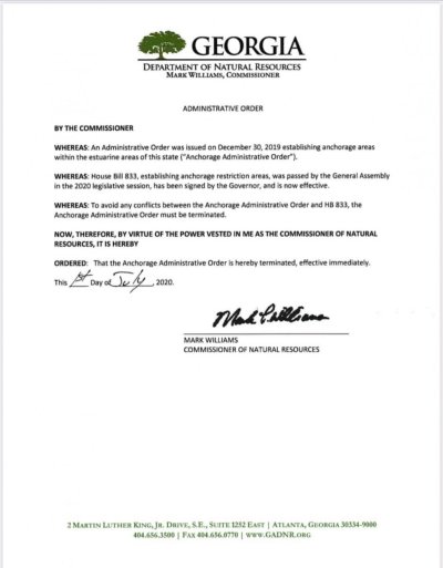
This was just forwarded to me. It looks official.
Thanks for posting that Larry. It is official.
The anchoring nightmare is over! HB833, written to replace the draconian HB201, was overwhelmingly passed by both chambers of the GA General Assembly and signed into law by Governor Kemp. It is now law! Thanks to all who helped support this.
HB*833*2019-2020 Regular Session
arisatx
Veteran Member
Georgia DNR has updated their maps to show the no-anchoring zones based on the new legislation HB833
https://gcmp.maps.arcgis.com/apps/webappviewer/index.html?id=b5a616ad152a462bad0b73cdb5eeb107
https://gcmp.maps.arcgis.com/apps/webappviewer/index.html?id=b5a616ad152a462bad0b73cdb5eeb107
arisatx
Veteran Member
I've tried to obtain the KMZ files for the various anchoring restriction areas (as were available previous for those areas defined under HB201). So far my inquiry has gone unanswered. A colleague of mine received a response stating that GA DNR had no current plans to make them available and that we should use the interactive map online - or print them out. This position exhibits disregard for the vessel operator who is trying to assess compliance, as well as the LEO who must enforce it.
As a second best alternative to show the "old" and "new" shellfish beds, I've taken screen shots off the DNR website and compared them to the previous KMZ areas in this photo album. You can see before / after shellfish areas in the pairs of photos.
The expansion is significant. The various boaters' rights organizations have come back together to draft a communication to the GA DNR that will be published later today.
https://photos.app.goo.gl/Z6WaR6qjiMUmzWgS8
psneeld
Guru
Being ignorant has become the American way.....understanding distances, speed of boat and a safe anchorage....how about any effort to see just how much anchorage area is necessary to accommodate cruisers, not permanently anchored vessels.
For slow boat, ita a long way between Savanah and Brunswick.....one reasonably protected creek is all I ask
For slow boat, ita a long way between Savanah and Brunswick.....one reasonably protected creek is all I ask
arisatx
Veteran Member
Here is a letter jointly sent by our boater's groups to the Georgia DNR Commissioner:
Commissioner Mark Williams,
On behalf of the group of boaters who worked with the GA DNR to create replacement HB 833 earlier this year, we seek some clarification on its implementation. You may recall that during our conference call, we stated our concerns about the shellfish harvest areas and you directed your team to follow up with James Newsome as our representative on this matter. This has not occurred to date and we would like to avoid another confrontational situation such as when HB201 was developed without stakeholder involvement.
The areas designated as shellfish harvest area buffers in the current map on the GA DNR website (Ref 1) are greatly increased vs those previously defined.
· Is GA DNR CRD representing the green shaded areas as currently approved shellfish growing areas?
Terms and Conditions preceding the map state (emphasis mine) "Anchorage restriction areas means those areas within the estuarine areas of this state in any location that lies within 300 feet of a marina, 150 feet from a marine structure other than a marina, or within 500 feet of approved commercial shellfish growing areas and designated public harvest areas as determined by the department."
· As much of the expanded shellfish growing areas include federally defined navigable waterways below the low water mark, has the US Army Corps of Engineers approved the designation USACE Nationwide Permit 48 (Ref 2 and 3) ?
· How much of the shellfish zones will be below the intertidal zone and be set aside for the mariculture technique utilizing cages suspended in the water column by floats?
· HB501 specifies that subtidal harvest zone leases must first be evaluated for impact against other public uses. (Ref 4). Has this been completed? If so, may we examine the evaluations? If not, what opportunity for public comment will you make available?
" Prior to offering a subtidal water bottoms lease, the department shall consider compatibility with other public uses of the marine and estuarine resources in proximity of the lease area that include, but are not limited to, navigation, fishing, swimming, and other forms of recreation."
· GA DNR has adopted the federal framework of National Shellfish Sanitation Program (NSSP), requiring shellfish waters meet the NSSP requirements before being designated as approved. Have these assessments been completed for all indicated areas? (Ref 5)
The boating group members seek a balance of interest among public access, waterfront property owners, and a resurgent shellfish industry.
Your feedback to clarify the above points would be most appreciated.
Coalition is comprised of:
America’s Great Loop Cruisers Association
CruisersNet
DeFever Cruisers Association
Marine Trawler Owners Association
National Marine Manufacturers Association
The Waterway Guide
Save Georgia’s Anchorages
Reference:
1- https://gcmp.maps.arcgis.com/apps/webappviewer/index.html...
2 - USACE Nationwide Permit 48 Commercial Shellfish Aquaculture Activities (Sections 10 and 404)
3 - Section 10 of the Rivers and Harbors Appropriation Act of 1899 https://www.epa.gov/.../section-10-rivers-and-harbors...
4 - HB 501 lines 341-346 http://www.legis.ga.gov/Legislation/20192020/185110.pdf
5 - US Food and Drug Administration - National Shellfish Sanitation Program https://www.fda.gov/media/98328/download
boathealer
Guru
Here is a letter jointly sent by our boater's groups to the Georgia DNR Commissioner:
Commissioner Mark Williams,
On behalf of the group of boaters who worked with the GA DNR to create replacement HB 833 earlier this year, we seek some clarification on its implementation. You may recall that during our conference call, we stated our concerns about the shellfish harvest areas and you directed your team to follow up with James Newsome as our representative on this matter. This has not occurred to date and we would like to avoid another confrontational situation such as when HB201 was developed without stakeholder involvement.
The areas designated as shellfish harvest area buffers in the current map on the GA DNR website (Ref 1) are greatly increased vs those previously defined.
· Is GA DNR CRD representing the green shaded areas as currently approved shellfish growing areas?
Terms and Conditions preceding the map state (emphasis mine) "Anchorage restriction areas means those areas within the estuarine areas of this state in any location that lies within 300 feet of a marina, 150 feet from a marine structure other than a marina, or within 500 feet of approved commercial shellfish growing areas and designated public harvest areas as determined by the department."
· As much of the expanded shellfish growing areas include federally defined navigable waterways below the low water mark, has the US Army Corps of Engineers approved the designation USACE Nationwide Permit 48 (Ref 2 and 3) ?
· How much of the shellfish zones will be below the intertidal zone and be set aside for the mariculture technique utilizing cages suspended in the water column by floats?
· HB501 specifies that subtidal harvest zone leases must first be evaluated for impact against other public uses. (Ref 4). Has this been completed? If so, may we examine the evaluations? If not, what opportunity for public comment will you make available?
" Prior to offering a subtidal water bottoms lease, the department shall consider compatibility with other public uses of the marine and estuarine resources in proximity of the lease area that include, but are not limited to, navigation, fishing, swimming, and other forms of recreation."
· GA DNR has adopted the federal framework of National Shellfish Sanitation Program (NSSP), requiring shellfish waters meet the NSSP requirements before being designated as approved. Have these assessments been completed for all indicated areas? (Ref 5)
The boating group members seek a balance of interest among public access, waterfront property owners, and a resurgent shellfish industry.
Your feedback to clarify the above points would be most appreciated.
Coalition is comprised of:
America’s Great Loop Cruisers Association
CruisersNet
DeFever Cruisers Association
Marine Trawler Owners Association
National Marine Manufacturers Association
The Waterway Guide
Save Georgia’s Anchorages
Reference:
1- https://gcmp.maps.arcgis.com/apps/webappviewer/index.html...
2 - USACE Nationwide Permit 48 Commercial Shellfish Aquaculture Activities (Sections 10 and 404)
3 - Section 10 of the Rivers and Harbors Appropriation Act of 1899 https://www.epa.gov/.../section-10-rivers-and-harbors...
4 - HB 501 lines 341-346 http://www.legis.ga.gov/Legislation/20192020/185110.pdf
5 - US Food and Drug Administration - National Shellfish Sanitation Program https://www.fda.gov/media/98328/download
Thank you for what you and others are doing related to this!
oscar
Guru
- Joined
- Oct 22, 2015
- Messages
- 1,098
- Location
- United States
- Vessel Name
- Lady Kay V
- Vessel Make
- 1978 Hatteras 53MY
Not trying to be flippant here, but is there anywhere left to anchor in GA or shall we just skip it?
FF
Guru
- Joined
- Oct 12, 2007
- Messages
- 22,552
"A vessel anchored while actively engaged in fishing."
A fishing license and a hand line might be a work around?
A fishing license and a hand line might be a work around?
arisatx
Veteran Member
Not trying to be flippant here, but is there anywhere left to anchor in GA or shall we just skip it?
There is. But not enough.
arisatx
Veteran Member
"A vessel anchored while actively engaged in fishing."
A fishing license and a hand line might be a work around?
Yes, as long as you have a GA Fishing License. Or you can claim safe harbor - had to anchor to attend to mechanical issues.
arisatx
Veteran Member
I have written this letter of inquiry to the USACE just now. Their contact information may be found here: https://www.sas.usace.army.mil/.../Regulatory-Program/
US Army Corps of Engineers
Savannah District
Regulatory Division
Dear Sirs:
I am a recreational boater who enjoys the coastal waters of our East Coast and in particular, the coastal waters of Georgia. I have followed with interest, the evolution of Georgia's regulations around navigation / anchoring in their estuarine waters, starting with House Bill 201 in 2019 and replacement House Bill 833 in 2020.
As a result of HB833, GA DNR has updated their definitions of no-anchoring zones as published on their website:
https://gcmp.maps.arcgis.com/apps/webappviewer/index.html...
Among the various zones, one in particular, "shellfish harvest" areas (shaded in green) have expanded dramatically between 2019 and 2020. These shellfish harvest areas are portrayed as "approved" on the GA DNR website and among the multiple requirements for approval is to receive a permit from US ACE for those areas in navigable waters. If one examines the published maps, there are many areas in navigable waters as well as established channels demarcated by Aids To Navigation by USCG and charted by NOAA. This also includes portions of the Atlantic Intracoastal Waterway, which as you know is important not just for recreational boaters but also for commercial navigation.
The reason for my email is to inquire as to the status of USACE approval of these shellfish harvest zones.
Thank you,
Ted Arisaka
O C Diver
Guru
- Joined
- Dec 16, 2010
- Messages
- 12,880
- Location
- USA
- Vessel Name
- Slow Hand
- Vessel Make
- Cherubini Independence 45
I fail to understand why the state of Georgia can't produce a better map / chart to explain what is anchorable and what isn't. What a PIA to figure out whether your favorite sports are ok or not. It seems that they could do a Google maps to allow you to drill down and have both the river names and the highway numbers. While they are at it, paint the magenta line on the chart for easy reference.
One of my regular spots is a creek that is about 100 yards wide. Half the width is ok; the other half isn't.
 Thankfully the side I anchor on is ok with this map drawing (bottom is the same on both sides with no shellfish).
Ted
One of my regular spots is a creek that is about 100 yards wide. Half the width is ok; the other half isn't.
Thankfully the side I anchor on is ok with this map drawing (bottom is the same on both sides with no shellfish).Ted
psneeld
Guru
We will be anchoring in Walburg Creek Thursday night.
All green!
I thought the green was shellfish areas and Walburg Creek was all green????
Civil disobedience?
Last edited:
High Wire
Guru
So a Georgia fishing license becomes an anchorage license with a fishing pole and line in the water? I can’t remember a single boat working shellfish anywhere in GA. Do they have a valid industry or is this a ruse to grab more area?
oscar
Guru
- Joined
- Oct 22, 2015
- Messages
- 1,098
- Location
- United States
- Vessel Name
- Lady Kay V
- Vessel Make
- 1978 Hatteras 53MY
Do they have a valid industry or is this a ruse to grab more area?
Well, that's kinda the point of the last 21 pages.
OldDan1943
Guru
- Joined
- Oct 2, 2017
- Messages
- 10,599
- Location
- USA
- Vessel Name
- Kinja
- Vessel Make
- American Tug 34 #116 2008
Keep an eye on DNR and the State legislature. I suspect, they will be expanding the no-anchor zones, administratively, quietly.
I worked for GA for over 20 years (different agency) ..... I have seen it in action.
"My daddy did it this way and this is how I am going to do it."
They may even go so far as transplant a segment of the shell fish population so they can expand the no-anchor zone.
I worked for GA for over 20 years (different agency) ..... I have seen it in action.
"My daddy did it this way and this is how I am going to do it."
They may even go so far as transplant a segment of the shell fish population so they can expand the no-anchor zone.
menzies
Guru
I thought the green was shellfish areas and Walburg Creek was all green????
Civil disobedience?
Anyone heard of any enforcement yet?
psneeld
Guru
Wasn't personally looking to be the test case....but I am in full support if you need an experienced witness... 
Seriously....that will be interesting. I have anchored in there many times...in a blow, had a few shrinpers come in to anchor too. There is that private facility on the island raising endangered species (well I think it is still there) so who knows whether it could be a factor. As opposed to Blackbeard creek that is less travelled.
Seriously....that will be interesting. I have anchored in there many times...in a blow, had a few shrinpers come in to anchor too. There is that private facility on the island raising endangered species (well I think it is still there) so who knows whether it could be a factor. As opposed to Blackbeard creek that is less travelled.
Last edited:
oscar
Guru
- Joined
- Oct 22, 2015
- Messages
- 1,098
- Location
- United States
- Vessel Name
- Lady Kay V
- Vessel Make
- 1978 Hatteras 53MY
Anyone heard of any enforcement yet?
If WE can't figure out what's what you think the average LEO can?
psneeld
Guru
Yes, because I can read a chart and pull out a ticket book.
What is so hard?
Thinking a law is silly isn't the same as enforcing it.
Just because we never saw LEO patrolling the GA waterways before, doesn't mean they won't now with easy targets and supplemental revenue ( if it is enough to make it their worthwhile).
What is so hard?
Thinking a law is silly isn't the same as enforcing it.
Just because we never saw LEO patrolling the GA waterways before, doesn't mean they won't now with easy targets and supplemental revenue ( if it is enough to make it their worthwhile).
Last edited:
OldDan1943
Guru
- Joined
- Oct 2, 2017
- Messages
- 10,599
- Location
- USA
- Vessel Name
- Kinja
- Vessel Make
- American Tug 34 #116 2008
I encourage you to write down the lat and long of where you anchor, in your log. book.
It maybe your only defense in court.
GA DNR better get their 'ducks in a row' and provide chart indicating the defined no-anchor areas by lat and long.
A line or lines on a chart as indicated, mean little in court.
It maybe your only defense in court.
GA DNR better get their 'ducks in a row' and provide chart indicating the defined no-anchor areas by lat and long.
A line or lines on a chart as indicated, mean little in court.
OldDan1943
Guru
- Joined
- Oct 2, 2017
- Messages
- 10,599
- Location
- USA
- Vessel Name
- Kinja
- Vessel Make
- American Tug 34 #116 2008
We're fines defined?
Maybe defined by the local, political appointed Justice of the Peace.
God help us all.
catalinajack
Guru
True enough but I will repeat what I said in a post very early in this thread. Passing through Georgia means, what, at most two overnights. Many of the anchorages that are now closed are quite remote, for example, the Wahoo River on the north of Sapelo Sound, miles and miles from any civilization. Anchor there late in the day and leave early the following morning. What LEO will want to be patrolling there and have to travel back to his home port 10 or 15 miles in the dark? Not likely. Plus, why spend all the valuable time patrolling remote anchorages on the off chance that one boater is caught. Resource allocation is always a consideration for any law enforcement agency. I'll take my chances. Plus, my boat always seems to break down when passing through Georgia requiring an emergency repair - overnight. Who needs a fishing license? I'll just replace that plugged fuel filter in the morning.
Yes, because I can read a chart and pull out a ticket book.
What is so hard?
Thinking a law is silly isn't the same as enforcing it.
Just because we never saw LEO patrolling the GA waterways before, doesn't mean they won't now with easy targets and supplemental revenue ( if it is enough to make it their worthwhile).
menzies
Guru
That's an interesting point.
There have been numerous times where I have anchored and been joined by a shrimper, Wahoo River was one of them.
It was anchored when we arrived in the evening, and still there when we left in the morning.
Will they be written up? Not likely.
There have been numerous times where I have anchored and been joined by a shrimper, Wahoo River was one of them.
It was anchored when we arrived in the evening, and still there when we left in the morning.
Will they be written up? Not likely.
FF
Guru
- Joined
- Oct 12, 2007
- Messages
- 22,552
If writing lat & lon of anchored spots , I would label it "crew rest" location.
Similar threads
- Replies
- 0
- Views
- 532
- Replies
- 9
- Views
- 2K
- Replies
- 4
- Views
- 1K
- Replies
- 16
- Views
- 2K
Latest posts
-

-

-
-
-

-

-

-
-
 Fixing boats in Exotic Places - are new boats really that bad?
- Latest: HeadMistress
-