Portland Canal?

The friendliest place on the web for anyone who enjoys boating.
If you have answers, please help by responding to the unanswered posts.

hrifraf

Member
Joined
Jan 1, 2016
Messages
15
Location
Canada
Vessel Name
Raven Song
Vessel Make
NP 38
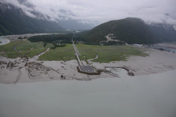
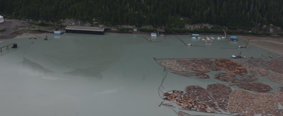
Has anyone here been up Portland Canal to Stewart/Hyder?

We are starting to make plans for this summer's cruise. One option is to go back up to Glacier Bay, but we are also considering staying in BC waters and exploring some of the more out of the way places. Portland Canal, Dean Channel, South Bentick Arm, for example.

However, I often find inlet travel long and boring. Some inlets, on the other hand, (Knight, Bute, Gardner) can be spectacular. We are wondering if Portland Canal is worth the trek, scenery wise.

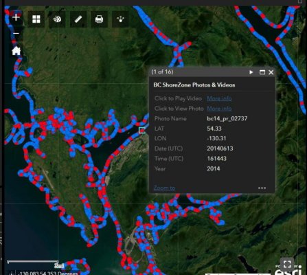
Any other suggestions for scenic stretches would be welcome.

As background, we have cruised the BC coast for a few years and are familiar with the main routes. Also, we have been around Vancouver Island a few times, and in 2022 we circumnavigated Moresby Is. We're bound to go back up to Glacier Bay at some point, just not sure if this is the year.
 
Have not been up Portland canal but have been near its mouth many times. When there is high pressure weather in the BC interior, the outflow winds can really blow hard. The north end of Dundas Island really gets it, and down toward Prince Rupert. Boats moving up and down from Ketchikan are affected. The winds are reminiscent of Douglas Channel near Kitimat.
 
Outflow winds

Ken; Thanks for your comments.

I have been under the impression that outflow winds were mostly a winter phenomenon. Have you encountered them during the May-Sept cruising season?


We haven't experienced significant outflows in our summer cruising, but maybe we've just been lucky!
 
Portland Canal is an interesting trip. At the western end, once out of Dixon Entrance there is some good cruising ground on both sides of the border. Bothersome Waggoners and Douglas provide some detailed information on these areas. Once heading east up the canal be prepared to get to Stewart in one day as anchorages along the way are sparse.

The history around Stewart and its mining days (still ongoing) spans a century. With a bit of ingenuity you should find some way to tie up and travel the area by foot.

The winds are often descending in the summer due to cold air from the mountains sinking into the canal and heading to the sea
 
Ken; Thanks for your comments.

I have been under the impression that outflow winds were mostly a winter phenomenon. Have you encountered them during the May-Sept cruising season?


We haven't experienced significant outflows in our summer cruising, but maybe we've just been lucky!

Certainly the worst of the outflow winds are in the winter months, but summer and the shoulder seasons can have them too, just like Douglas Channel.
 
I guess technically you would need to be checked into either Canada or the US, and then only anchor/dock on that side of the canal. Or maybe nobody cares?

I have only poked around the bottom/west end, mostly staging to/from Dixon.
 
I have never been to the PNW so whenever these discussions come up I always study the Google maps to understand what folks are talking about. Is it my imagination or is much of the yachting infrastructure kinda third world where this thread is talking about?
 
I have never been to the PNW so whenever these discussions come up I always study the Google maps to understand what folks are talking about. Is it my imagination or is much of the yachting infrastructure kinda third world where this thread is talking about?

I wouldn't characterize it as Third World, but it's quite different from some other areas. If you want to go from marina to marina, you are in the wrong place. Ports are predominantly commercial, with accommodations for pleasure boats. People visit the area for the scenery, wildlife, fishing, and piece and solitude. Most nights are spent at anchor in unpopulated areas. No dinner out or visits to the bar, no stores, no Uber, and mostly no cell service. There are exceptions of course, but they are few and far between.

South of Campbell River things are more developed, but it's nothing like the US East Coast.
 
Haven't done the channel, just visited Hyder to view the bears. If you are into grizzly bears up close then it may be worth the trip. At times you may be about 30 feet from them as they chase fish in the creek. It's scary how close you are but they seem to like the fish better than us. More here https://www.fs.usda.gov/detail/r10/specialplaces/?cid=fsbdev2_038787

Also here is a blog post we did about our visit and some bear pictures. https://janchez.blogspot.com/2012/08/the-bears.html

There may be a town taxi that could get you from the docks to the bears. When we were there the bears were active in the mornings and evenings so that could throw a twist in transportation to and from the boat.

I hear you on running long inlets, sometimes you can only look at so many hours of green trees, cliffs and random waterfalls.
 
Thanks everyone

Thanks everyone for your tips. As I said earlier, we are still considering our summer plans. Stewart/Hyder might be on the list, or maybe a destination for a road trip some time in the future.


PierreR - As TwistedTree mentioned, what we have here on this coast is Wilderness, with a capital W. If you are interested in what cruising here looks like you are welcome to have a look at our trip blog: riffelages.ca
 
If you would like to "fly" the shoreline of Portland Canal, you can do so at the ShoreZone site here:
https://www.shorezone.org/interactive-shorezone-maps/

Zoom in to an area of interest and when you see the flight track, click on a red dot to choose either video or photos and click along. I attach a photo of the boat harbor at Hyder and the one at Stewart. The whole BC coastline is on this site. Photos are free to download.

The Anyox Mine site is an incredibly interesting location too.
 

Attachments

  • 19960149519_527db2ac10_k.jpg
    19960149519_527db2ac10_k.jpg
    69.8 KB · Views: 18
  • 20138262832_84213ce4a0_4ka.jpg
    20138262832_84213ce4a0_4ka.jpg
    54.8 KB · Views: 19
Thanks John. Looks very interesting. Unfortunately I can't get the site to load images, but I will keep checking back to see if it's a temporary situation.


Harald
 
Gardner Canal

Hrifraf-

I plan on spending 7-10 days in Gardner Canal this May on the way to Alaska. I’ve never been before, and I’m very excited to get to the end of the road in Kitlope. Do you have any advice on “must-do’s” in the Gardner Canal area? Also, which of the hot springs in the general area, including the Douglas Channel and Bishop Bay, do you recommend?

Many thanks in advance-

Steve
 
Harald
When you Zoom in and click on a red dot, a little window should open, allowing you to click on "Click to View Photo" link that will open a Flickr page. This is working OK in Google Chrome this morning - don't know about other browsers. There are tens of thousand of photos that are free to download. Available for Alaska too.
 

Attachments

  • SZ_Access1.jpg
    SZ_Access1.jpg
    85.1 KB · Views: 13
Gardner Canal

Hi Steve;
We have been up the Gardner Canal as far as Chief Matthews Bay. We hope to be back up there this year and go right to the end. It's a beautiful trip, especially if the weather is nice.


The Bishop Bay hot springs are popular. You can socialize with others most evenings or have the place to yourself early in the morning.
Further along, there is another nice hot spring, in the bay between Shearwater and Europa points. There are two mooring buoys in the bay, but no dock. There is a hut, with the changing room upstairs and the hot pool underneath.


In Ochwe Bay, the Paril river is fun to explore. It's good for paddling - if the tide is up you can get a mile or so up the river. We've been up there several times - sometimes there are lots of bears, sometimes none.


Kiltuish inlet is beautiful. There is a small tidal rapid at the entrance - best on a high slack. Probably best to check it out with the dinghy at low tide. Inside, the scenery is great. We spent a couple of nights in there sitting out a storm, and I will definitely go back.


Another great spot is Owyacumish Bay. We were there in early June and there was still a big patch of snow just above one of the creeks. Dramatic scenery in the bay and across the canal.


Chief Matthews Bay has a big grassy estuary. There weren't any bears around when we got there, which allowed us to enjoy the wildflowers.


For photos of our trip there in 2020 (during the height of Covid), see this page of my trip blog:
https://riffelages.ca/?page_id=1652


Cheers:
Harald
 
Steve

1. in Gardner Canal, you will lose VHF to the Coast Guard and cell, so be sure to have some type of satellite communication for emergencies.

2. Read Cecil Paul's "Stories from the Magic Canoe". Cecil was one of the last Xenaksiala speakers and born in the Kitlope. Cecil was the champion that led to the Kitlope Conservancy.

3. A link to Time Colonist Newspaper Article on Cecil and the Kitlope:
https://www.timescolonist.com/islander/book-excerpt-haisla-history-in-an-elders-own-words-4672247

4. A link to BC Parks's Description of the Kitlope:
https://bcparks.ca/huchsduwachsdu-nuyem-jees-kitlope-heritage-conservancy/

5. There is a Haisla/Xenaksiala Guardians cabin near the mouth of the Kitlope River and it is recommended that you check with them before going a shore in the Kitlope.
 
Harold and John -

Thanks so much for the information. We’re really looking forward to cruising this new-to-us area.

Cheers!

Steve
 

Latest posts

Back
Top Bottom