Hurricane Ian was Tropical Storm Ian was Tropical Depression 09

The friendliest place on the web for anyone who enjoys boating.
If you have answers, please help by responding to the unanswered posts.
Most models have it going south of Tampa Bay now, possibly Sarasota and below. That’s much better news for Tampa/LBK. More moves east are possible, allegedly.

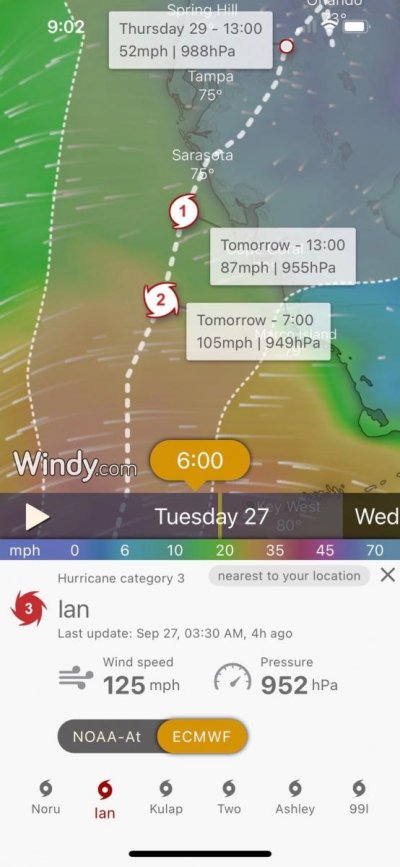
Windy’s hurricane tracker NOAA, which must be an average of the models?
IMG_5408.jpg

GFS has it going into Cape Coral
IMG_5409.jpg

Euro south of Sarasota
IMG_5410.jpg
 

Attachments

  • IMG_5407.jpg
    IMG_5407.jpg
    68.4 KB · Views: 38
Last edited:
Looks like I will be doing the same as healhustler, good luck Larry. We may have a little better chance than LBK, being at Twin Dolphin with floating docks.

Bob
Let's hope. We're on E dock - hope the first time we meet is not during a salvage planning meeting..
Stay safe
 
Historically, the Euro has been one of the more accurate models. Regardless it’s looking better for the Tampa area and takes them out of the danger side. Still not good but better.
 
Absolute mixed emotions this morning. The track has turned away from us, and I doubt we will get anything more than some rain and breeze. So that is joy. But on the other hand, the track has turned toward an area that I have a lot of fond memories of from my cruising days (1995-1999), and it looks as if it is going to be a bad one. So that is sadness.
 
Let's hope. We're on E dock - hope the first time we meet is not during a salvage planning meeting..
Stay safe

I hope not, it is starting to look a little better for us, but for Ft. Myers.......... We are on the C dock.
 
Since I’ve been obsessing over this storm for days now, I made this meme for my wife. She chuckled.

IMG_5416.jpg

Latest Tropical Tidbits video:

https://youtu.be/psxR5JRjCPA
 
Last edited:
Very cool! Thanks for those links.
 
This website is great.

https://cera.coastalrisk.live/

It has detailed info regarding surge. Zoom into the map for details. It may load slow. You can also go back and see historical maps based on previous tracks. Tampa Bay looked bad on NHC track 13 ( drop down at top of page). The current track looks very bad for Manasota key and surrounding area.

I prepped the boat for worst case in Tarpon Springs yesterday including removing anything valuable, tools, new parts etc, and doubled up and loosened the ropes as much as I dared for 8-10 foot surge. I think Im going to head back up and tighten them back up about 12 inches on either side. Current surge in my river is now only 2-3 feet. I am definitely grateful for that, but very worried for Venice, Boca Grande.

Just got done with house prep an hour ago. Exhausted.

Good luck everyone.
 
Last edited:
Good luck to everyone in the path. Hopefully all the prep work is done and folks have evacuated.
 
FishWeather shows the eye crossing over Englewood. Not good for me. :(
 
Waiting for the 11 PM update. On Longboat Key (Sarasota) we were in the bullseye but easterly wobbles may have helped us get on the west side of the core. This would blow all the water out of the bay and likely leave my boat innthe mud as with Irma a few years ago. Hope my house windows hold up. Exhausted now and not sure how much I have left for damage emergencies.
 
Ian is wobbling a smidge north now at 4:00 a.m.

The storm's path still shows it coming ashore south of Sarasota.

Hurricane Ian will then take 24 hours to get from Sarasota to Orlando, which obviously means that not even major hurricanes can beat the traffic on I-4.

Stay safe, friends to the south,
Mrs. Trombley


I'm surprised no one has yet to blame it on global warming.
 
Well crap, now it’s almost a cat 5. Was hoping wind shear was going to disrupt it some before making landfall but looks like that’s not going to happen.

Peak surge for Ft Myers area 12-16’! [emoji15]

IMG_5421.jpg
 
Last edited:
So we put the shutters up on the house in Ft. Myers Saturday which now seems like a good thing. We moved to the boat in Jacksonville which now seems like a bad thing...

Moving to a hotel later today to ride it out. Hopefully we have one or the other to go back to after the storm! Take care everyone in Florida!
 
@cardude Thanks for posting storm surge info, was kind of low key thinking about that in back of my head. Looks like Jacksonville at 3-5 doesn't seem too bad.

Going to cross fingers and hope for best.
 
In 2017, Jacksonville had record flooding from Irma. This was on last nights news specific for Jacksonville for what it’s worth. We are more optimistic.
 

Attachments

  • D9DDF04D-0F94-49FB-822D-96224CC1433B.jpg
    D9DDF04D-0F94-49FB-822D-96224CC1433B.jpg
    81.9 KB · Views: 34
In 2017, Jacksonville had record flooding from Irma. This was on last nights news specific for Jacksonville for what it’s worth. We are more optimistic.


Larry,

What is the the surge projected to be at Ortega Landing marina? It’s called Port 32 now?
 
Bill: They aren’t talking storm surge but the river is predicted to rise 4’. The timing with the tides and the 6-14” of rain that’s predicted can change all that. We’re right on the edge but they are predicting at least a 70% chance of flash flooding. What happens south of us can change things for Jacksonville.
 
Watching a livestream of the storm coming ashore in Punta Gorda:


Another link, different guy:


Don't think the first link worked, look for Reed Timmer on Youtube. Livestream is called:

LIVE HURRICANE IAN storm chase approaching category 5
 
Last edited:
Bill: They aren’t talking storm surge but the river is predicted to rise 4’. The timing with the tides and the 6-14” of rain that’s predicted can change all that.
My marina Lamb's went ahead and lowered my mast (which required lowering bimini), funny thing they didn't even ask, just sent me a text letting me know they did it, which I am totally fine with the no notice, was happy to hear they were looking after things and taking proactive measures.
 
Well crap, now it’s almost a cat 5. Was hoping wind shear was going to disrupt it some before making landfall but looks like that’s not going to happen.

Peak surge for Ft Myers area 12-16’! [emoji15]

View attachment 132426

That's just ridiculous! Whoever made that storm surge map for the area Englewood to Bonita Beach needs to be drug tested or fired for incompetence.

When the water reaches 10', there will probably be close to a thousand square miles inside the barrier islands, covered with water. Between the speed the hurricane is traveling to land, the shallowness of the coastal water to 10 miles off shore, and the low level of land and existing estuaries, 12 to 16' is total BS. Can they not see people will question their credibility next time?

Ted
 
Yeah, it seems like these storm surge forecasts are usually overstated. Is this by design?
 
Got kicked off LBK yesterday at 6 PM yesterday as with fellow Manatee owners, the Anderson’s on (Mango Mama). They left LBK yesterday and made a reservation at a hotel in in North Port to escape the storm. Now they’re directly in eye path and could get winds of 150 mph. What a mistake!!

I hope for the best, but iur favorite cruising grounds and marinas in Sanibel, Cayo Costa, Boca Grand, Captiva, etc. are in the eye now. We’ve got problems for the next 24 hours, but those folks, well…:ermm:
 
Back
Top Bottom