Furuno gearheads please

The friendliest place on the web for anyone who enjoys boating.
If you have answers, please help by responding to the unanswered posts.

klee wyck

Guru
Joined
Feb 8, 2014
Messages
988
Location
USA
Vessel Name
Domino and Libra
Vessel Make
Malcom Tennant 20M and Noordzee Kotter 52
New boat, new gear, need help getting up to speed.
The electronics on this new to me boat worked well enough for our crossing and trip down the SOC but now the important stuff....
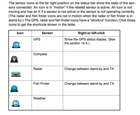
I am getting depth from two sources and it is reliable it seems, but my fish finder is stuck in standby and will not scroll. The little fishfinder icon in the upper right corner of the display has an X over it.
I have been to the fish finder menu and tried to find a way to get out of standby but no joy.
Can anyone help?
 
What model display is it? This explaination is for one of the MFD.....
 

Attachments

  • Screen Shot 2021-11-13 at 6.42.15 PM.jpg
    Screen Shot 2021-11-13 at 6.42.15 PM.jpg
    126.9 KB · Views: 12
DFF3 is the model, not sure which transducer.

The DFF3 will work with a range of Furuno MFDs, as well as stand alone software, including the various Nobeltec / Time Zero flavors. The transducer doesn't really matter, it is more a question of the software running the Dff3 and its transducer. Some of the earlier Furuno menus were not very intuitive (but their latest is pretty good).
You should be able to find an on line manual for yours.
 
Solved! Between these posts, the manual, and the PO we are scanning and scrolling.
Thanks for chiming in.
 
While it may be solved, it does help others if there's a bit more model/part/type info. Brings up better search results later too.

My two cents, if you have more than one source for "the same" data it really helps to make sure that each device on the network has it's own instance ID. NMEA-2000 allows for this but if you don't set it then you can end up where a chart plotter is randomly picking up the data from the "wrong" source. I have more than one source for GPS and heading data and ran afoul of that problem until I set the ID on each of them, and made sure each chart plotter was specifically configured to use the one I wanted.

Point well taken.
In this case, the mfd is being driven by the Navnet 3D software version from around 2010. There is a TZT monitor that is newer that is slave to this mfd I think. The sounder is DFF3 as mentioned. I was just looking for the wrong icon to click on in order to take it out of standby. In the manual and in a prior post here, it looks like a puck and is referred to as being on the far right in the upper right corner of the mfd display. In fact, the icon looks like a wireless connection and is second from left in the upper right of the display. I had just written off that icon offhand as a wireless network and failed to try it. One left click on that icon and we were up and running.
To your point, if I do not turn on the sat compass first and wait a minute, everything on the dash gets confused about which gps it is supposed to use. As long as I fire up the SD50 fist we are good.
I get another sounder on an RD30 but it is depth only. There are two transducers. One is a thru hull/in hull and the other reads through the hull where the core has been removed and the hull is just laminated frp-resin all the way through. This transducer is in a box in what looks to be an oil bath?
 
Back
Top Bottom