Hurricane Ian was Tropical Storm Ian was Tropical Depression 09

The friendliest place on the web for anyone who enjoys boating.
If you have answers, please help by responding to the unanswered posts.
Greetings,
While everyone is rightly concerned about Ian, take a moment and see what devastation Fiona has brought to the Canadian Maritimes.

I think there are a few TF members in that region.

A TF member’s comments from yesterday:

“Soooo, us little tugboaters trying to cross the atlantic are hurricane hiding out in St John's, Newfoundland... Fiona is west of us rocking Halifax this morning. Big cliffs here blocking the wind.... back to sea on Monday...”

And from yesterday afternoon:

“So,34' waves today off port of basque...yup, think we will stay put in st johns for another 2 days..”
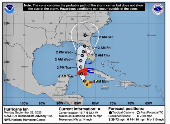
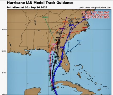
 
Tropical Storm Ian was Tropical Depression 09

Watching one of Mike’s weather page latest videos, and he doesn’t buy the shift westward because it relies on the GFS model, which he thinks is kind of weak for whatever reason.

The Euro model, which he prefers, has the eye going right over LBK/Bradenton as shown on Windy here. The good news is most models show significant weakening before it hits land due to wind shear/cold front dry air, but it will obviously still be bad.

IMG_5402.jpg

 
Last edited:
Watching one of Mike’s weather page latest videos, and he doesn’t buy the shift westward because it relies on the GFS model, which he thinks is kind of weak for whatever reason.

The Euro model, which he prefers, has the eye going right over LBK/Bradenton as shown on Windy here. The good news is most models show significant weakening before it hits land due to wind shear/cold front dry air, but it will obviously still be bad.


I went to the National Hurricane Center website this morning to see what they are thinking. Their pictures are pretty, but the written discussion is more interesting. What they say in the discussion, and this is not a direct quote but close, is something like this: "Some of the models have it further to the west, and some of the models have it further to the east, so we are going to draw our picture such that it is between those two extremes."


Yeah, well it just seems to me that is misleading somewhat. Either the west models are wrong or the east models are wrong. But the path is not going to be a compromise between one right and one wrong.


Bill (shaking his head)
 
Tropical Storm Ian was Tropical Depression 09

Yeah, the giant cone is very broad at this point, but I assume that is by design. They want everyone in it to be on high alert until the models begin to converge over the next few days.

I don’t remember the models disagreeing so much before, but maybe I’ve not been paying attention.

And now the latest 11am GFS has shifted to the east some, so maybe they are beginning to converge.

 
Last edited:
I went to the National Hurricane Center website this morning to see what they are thinking. Their pictures are pretty, but the written discussion is more interesting. What they say in the discussion, and this is not a direct quote but close, is something like this: "Some of the models have it further to the west, and some of the models have it further to the east, so we are going to draw our picture such that it is between those two extremes."


Yeah, well it just seems to me that is misleading somewhat. Either the west models are wrong or the east models are wrong. But the path is not going to be a compromise between one right and one wrong.


Bill (shaking his head)

Not really when you factor in uncertainties then assign different probabilities to all of them..

That why there are spaghetti models,, when they star to agree with each other, predictions become more accurate.

Usually a couple or concentration of spaghetti strands are right along the average prediction.
 
Last edited:
This mornings update. The models are still not in close agreement.
 

Attachments

  • 6E7D0F0A-5221-4CEA-9A71-EE304D14CE95.jpg
    6E7D0F0A-5221-4CEA-9A71-EE304D14CE95.jpg
    134 KB · Views: 35
  • 77FCE588-2238-4A38-B9A4-E5BE1F1F883E.jpg
    77FCE588-2238-4A38-B9A4-E5BE1F1F883E.jpg
    117.7 KB · Views: 35
The Windy model didn't show the westward shift which turned out to be correct. Shows it takes a path sevetal miles west of Pinellas beaches. Might not be "worst case" but wont be great. Fingers crossed ....

Surge in upper Tampa Bay may be awful. Best to all my neighbors in St Pete area.

Peter Screenshot_20220926-052409_Windy.jpg
 
Yeah this track is looking bad for Tampa, St Pete, Bradenton/LBK, folks. Storm surge of 6-10 feet in these areas will be very destructive.

Also, some of the latest models (gfs, euro) have the storm slowing down and skirting the coast for two plus days, pushing a lot of surge/rain into the coast for days.
 
Last edited:
I recall when Irma went by, I sat in the salon of my boat and thanked it for the service that it given me, even the frustration it had given me. I guess I’ll be doing the same thing this time. There’s no way to tie for a 9 foot surge in my canal.
 
The west coast of Florida is on the “bad” side of this one for wind and storm surge. This will be a throwback to the 2004-2005 seasons.
 
Looks like I will be doing the same as healhustler, good luck Larry. We may have a little better chance than LBK, being at Twin Dolphin with floating docks.

Bob
 
Good luck, Bob. I guess I’ll be stocking up on marshmallows again.
 
I suppose this is a dumb question, but I will just ask it anyway. If I had a boat on the west coast of Florida (which I don't -- this is just theoretical) and I ran it up the Caloosahatchee River at Ft. Myers, beyond the first lock, wouldn't that negate the effect of a storm surge???
 
I suppose this is a dumb question, but I will just ask it anyway. If I had a boat on the west coast of Florida (which I don't -- this is just theoretical) and I ran it up the Caloosahatchee River at Ft. Myers, beyond the first lock, wouldn't that negate the effect of a storm surge???


According to a poster on Cruiser Forum:


Currently a steady stream of boat traffic upstream in the [FONT=&quot]Caloosahatchee River.[/FONT]
[FONT=&quot]
[/FONT]
[FONT=&quot]Upstream= further inland, further from predicted storm path and if past the Franklin lock, likely "storm surge proof". [/FONT]
 
Being inland of a lock should protect from wind driven surge (unless it's so massive that it over-flows the lock). It won't necessarily protect against flooding if there's sufficiently extreme rain, but it's certainly a much safer place to be.
 
I suppose this is a dumb question, but I will just ask it anyway. If I had a boat on the west coast of Florida (which I don't -- this is just theoretical) and I ran it up the Caloosahatchee River at Ft. Myers, beyond the first lock, wouldn't that negate the effect of a storm surge???


I hid in a little canal neighborhood behind the Ortona Locks (near the River Forest yard) during Irma and it worked out well. Lots of wind but no surge obviously.
 
Sadly, the southern FL TV stations have to change for "You are all going to die" to "You are all going to drown."
 
Thanks for posting. The first time I’ve watched his channel. He does a great job at looking at the models and explaining in layman terms.


It was a great explanation. However, some laymen are obviously a lot better at understanding than other laymen. :) Lots of the talk was too technical for this old boy to follow. I did gather, though, that it was 50-50 probability of whether it would go to the east or to the west. And that once it had passed over the western tip of Cuba that things would become clearer


Bill
 
Tropical Tidbits is definitely a good follow. I also follow Mike’s Weather Page. He’s not quite as precise and technical, but his site has tons of good storm info on it.
 
All relative. Being 20 miles to the left of the centerline is a helluva better than being 20 miles to the right. May not make it good, but definitely makes a BIG difference.

Latest NHC projection attached. Remarkably steady forecast.......for now

PeterView attachment 132299

EXACTLY my situation in 2018's Cat 5 Michael. Had it hit 20 miles west of the Mexico Beach landfall, I'd be writing this from a new home.

The forecasters used to say that they wished the centerline of warning cones was never published because these storms have an even chance of landing anywhere within the cone. That said, the cones narrow on the landfall point as the storm closes the coast effectively making the centerline a moot point. While in the cone earlier today and last night, I got gas for the emergency generator and tested it and filled the tanks of the vehicles and confirmed my boat's hurricane hole with the property owner there.
 
It was a great explanation. However, some laymen are obviously a lot better at understanding than other laymen. :) Lots of the talk was too technical for this old boy to follow. I did gather, though, that it was 50-50 probability of whether it would go to the east or to the west. And that once it had passed over the western tip of Cuba that things would become clearer

Bill

Like most things when it comes to my weather comprehension, I find myself nodding and looking serious while listening to Tropical Tidbits, then realizing that I have no idea what he's talking about.

I still enjoy the videos though. Maybe I can hope that a little bit is sinking in each time?
 
All relative. Being 20 miles to the left of the centerline is a helluva better than being 20 miles to the right. May not make it good, but definitely makes a BIG difference.

Agree. My house/boat was about 20 miles from "center" on the dirty side of Ida last year. We got whacked pretty hard at the house. Boat was fine.

However, the degree of increased wind damage between my location and ground zero in that short distance was truly remarkable. Exponentially worse.

Waiting out Ida was, to me, worse than riding it out. As a friend commented: "it's like being stalked by a homicidal turtle." My thoughts, prayers, and good wishes to all in the potential path of this thing.
 
I just got a message from my neighbor who has a boat sitting right next to mine here in Longboat Key. It looks like we’re both gonna get it bad, but he is 2000 miles away in Nova Scotia where he just got his butt kicked by hurricane Fiona. Poor guy is building a new house there and it knocked the windows out, and now he has to cope with being 2000 miles away from his next to butt kicking.

We got the notice this afternoon that we have to be off this island by 6 PM because water, sewer and electric will be cut off at 8 PM. Like in irma, it will probably be days before we can get back on the island and find out if your boat survived and how much damage there is to your residence.
 
Greetings,
While everyone is rightly concerned about Ian, take a moment and see what devastation Fiona has brought to the Canadian Maritimes.


https://www.cbc.ca/news/canada/newfoundland-labrador


https://www.cbc.ca/news/canada/nova-scotia


I think there are a few TF members in that region.
Thanks RTF. I saw horrifying news film of the Canadian east coast storm but found no mention on TF before your post. Guessing most Canadian TFers are on the west coast, but I feel for PEI we had the pleasure of visiting some years back, as well as other east regions. Best wishes to TF east coast members.
 
Greetings,
Mr. BK. Thanks for the sentiment. Only one death reported, as far as I'm aware, at the moment. https://www.cbc.ca/news/canada/newfoundland-labrador/hurricane-fiona-damage-sunday-1.6595070

We toured Newfoundland last year by car. Affectionately known as "The Rock" by locals it is probably one of the most magnificent places I've ever visited. Truly mind boggling IMHO.

Not hard to imagine the scope of the destruction as small villages and hamlets might be clustered in a small cove VERY close to the sea, not much above sea level and with storm surges estimated to be upwards of 34'...devastation.


If interested, it was less than 50 years ago that the last of the "outports" were abandoned.
https://www.atlasobscura.com/articles/newfoundland-abandoned-resettlement-villages
 
Last edited:

Latest posts

Back
Top Bottom