|
11-06-2018, 04:40 PM
|
#1
|
TF Site Team
City: Brisbane
Vessel Name: Insequent
Vessel Model: Ocean Alexander 50 Mk I
Join Date: Mar 2012
Posts: 3,135
|
Charts for Australia - Cmap or Navionics?
I have been using Cmap charts most of the last 6 years on a Time Zero display, and am generally happy with them. I also have their satellite photos, and although they are OK for the coast they are hit or miss for the islands and outer reef areas, and not particularly good resolution. Google Maps is far better for satellite pics, but is not integrated with the chartplotter.
Now TZ have advised that there is an updated Navionics chart available, although 'it is not inexpensive'! I'm curious whether anyone using Navionics can comment on them, or even compare to Cmap if you have both.
__________________
Advertisement
__________________
Brian
|
|
|
11-06-2018, 05:09 PM
|
#2
|
Guru
City: Sydney
Join Date: Jul 2015
Posts: 1,646
|
For the insignificant cost of Navtronics and a iPad or such its a no brainier to have a portable reliable stand alone back up. Comparison ?? Navtronics is updated weekly ?? Cmaps ? I also think Navtronics is more user friendly
__________________
|
|
|
11-06-2018, 05:47 PM
|
#3
|
Member
Join Date: Oct 2018
Posts: 5
|
We used Navionics to cruse OZ in 2016 and found it to be awesome. Far more detail and more updated than the CMAP charts on our PC. For instance, Bundaberg had its river completely changed by flooding the year before we were there and the chart was already update to show the new course of the river and all the new nav aid positions.
And yeah, it was WAY spendy, but for us it took us all the way through NZ and OZ so was a deal for us.
|
|
|
11-06-2018, 07:01 PM
|
#4
|
TF Site Team
City: Brisbane
Vessel Name: Insequent
Vessel Model: Ocean Alexander 50 Mk I
Join Date: Mar 2012
Posts: 3,135
|
Quote:
Originally Posted by gaston
For the insignificant cost of Navtronics and a iPad or such its a no brainier to have a portable reliable stand alone back up. Comparison ?? Navtronics is updated weekly ?? Cmaps ? I also think Navtronics is more user friendly
|
Navtronics? You mean Navionics? The iPad app is "Boating Australia & NZ HD" isn't it? Fairly average reviews particularly the older ones, not sure if it has improved or not. Like some other apps they want an annual subscription payment as well. Not very appealing.
I have plenty of backup - iSailor on iPad is OK, but not as detailed as I would like. I can also move the chartplotter from my RIB to helm of Insequent (power cable already installed).
I would want to use it as my main Nav package.
__________________
Brian
|
|
|
11-06-2018, 07:08 PM
|
#5
|
TF Site Team
City: Brisbane
Vessel Name: Insequent
Vessel Model: Ocean Alexander 50 Mk I
Join Date: Mar 2012
Posts: 3,135
|
Quote:
Originally Posted by WayneDana
We used Navionics to cruse OZ in 2016 and found it to be awesome. Far more detail and more updated than the CMAP charts on our PC. For instance, Bundaberg had its river completely changed by flooding the year before we were there and the chart was already update to show the new course of the river and all the new nav aid positions.
And yeah, it was WAY spendy, but for us it took us all the way through NZ and OZ so was a deal for us.
|
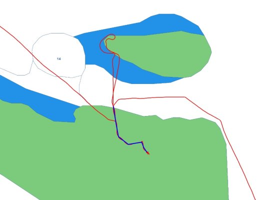
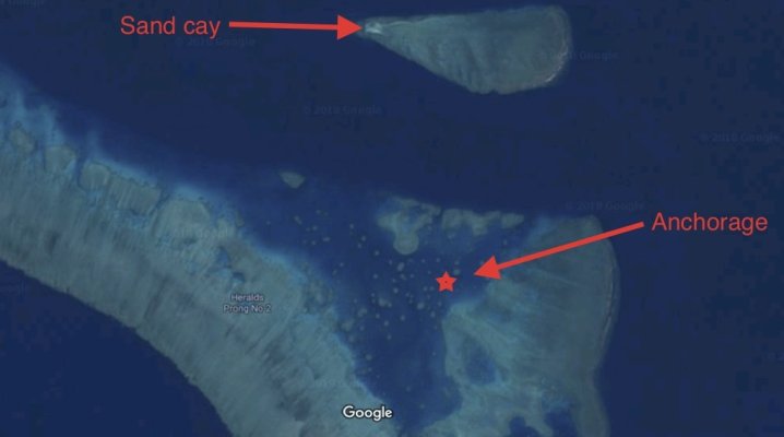
Interesting! How old were the Cmap charts? What is the Navionics detail like for the Outer Reef areas? Pic shows the Heralds Prong No 2 reef area I was at a few weeks ago. The green area is just an envelope of the area where shallow reef occurs. The Google maps sat image shows a lot more detail. Would you be able to post a Navionics screenshot of this area?
__________________
Brian
|
|
|
11-06-2018, 08:06 PM
|
#6
|
Dauntless Award
City: Wrangell, Alaska
Vessel Name: Dauntless
Vessel Model: Kadey Krogen 42 - 148
Join Date: Jan 2013
Posts: 2,800
|
Two things:
I've noticed with C-Map that sometimes in their transition from close-in to out, they display that overview with no detail. Not sure if it's a rendering issue with Coastal Explorer or inherent in C-Map. But in any case, IN CE if i continue to zoom in, high resolution returns.
I like C-Map for the cost.
I like Navionics for a tablet, NOT for a MFD, because they are too expensive. But for a tablet, they are a no brainer at $50 to 70 US.
Think of using it that way.
|
|
|
11-06-2018, 08:35 PM
|
#7
|
TF Site Team
City: Brisbane
Vessel Name: Insequent
Vessel Model: Ocean Alexander 50 Mk I
Join Date: Mar 2012
Posts: 3,135
|
Richard
I have not observed that zoom issue using TZ Navigator v3 and C-Map.
Navionics have a chart viewer online (Navionics Web API). I have just used it to view areas I have recently cruised, and while it is OK I noticed that in places its inferior to C-Map. What I am unsure of is whether the online chart I'm looking at is the same as the expensive-to-purchase MFD version. Do you know?
__________________
__________________
Brian
|
|
|
 |
Thread Tools |
Search this Thread |
|
|
Display Modes |
Linear Mode
|
Posting Rules
|
You may not post new threads
You may not post replies
You may not post attachments
You may not edit your posts
HTML code is Off
|
|
|
|
» Trawler Discussions |
|
|
|
|
|
|
|
|
|
|
|
|
|
|
|
|
|
|
All times are GMT -5. The time now is 05:13 PM.