Dorian aims for East Coast of Florida

The friendliest place on the web for anyone who enjoys boating.
If you have answers, please help by responding to the unanswered posts.
I’m about to throw myself a pity party. I can’t believe the first time I make the (stupid) decision to leave the boat in the Bahamas during hurricane season I’m gonna get hit. I swear. I feel like a hurricane magnet.

(Pity party over)

What's the update?
 
This here is one of the costs of year round boating. Go north, no ‘canes, just snow half the time.
 
Looking at that map..... I see the H hurricane - 74-110 mph AND now a M for windspeed greater than 110. M stands for 'mudder frickin big ass storm'?
 
Thanks. This is from the Abaco forum, and one of the reasons I’m freaking out just a little. 10-15’ storm surge on GTC would be freaking scary.

A lot could still change in the track - but as of 8:00pm EST Wed, the european model - which many consider to be the most accurate - has the storm passing more or less directly over Marsh Harbour / TC - I asked Chris Parker at the Marine weather center about possible storm surge in the area and he said 10-15 feet. Also intensification to cat 3-4 is absolutely on the table. There is very little to stop the storm intensifying between now and when it is due to pass the Abacos. Chris is having free facebook live broadcasts at 6:00pm EST until the storm has passed, anyone in its way would be well advised to participate. Here is link to today's broadcast.. https://www.facebook.com/marineweath...3539081041405/

Dude, feel for you, know the fear well. Got a while to go till November and this mess over till next August. FWIW I never count Louisiana out till then, talk about a hurricane magnet. Good luck amigo. Need to meet something when I’m in Corpus Christi.
 
I aint saying where on the east coast of FL I dock.
If I dont mention it, I hope the hurricane cant find me.
 
I always wondered if we loaded a neighborhood full of mobile homes onto a container ship and sent it out to sea would the hurricane follow it?
 
Thanks. This is from the Abaco forum, and one of the reasons I’m freaking out just a little. 10-15’ storm surge on GTC would be freaking scary.

A lot could still change in the track - but as of 8:00pm EST Wed, the european model - which many consider to be the most accurate - has the storm passing more or less directly over Marsh Harbour / TC - I asked Chris Parker at the Marine weather center about possible storm surge in the area and he said 10-15 feet. Also intensification to cat 3-4 is absolutely on the table. There is very little to stop the storm intensifying between now and when it is due to pass the Abacos. Chris is having free facebook live broadcasts at 6:00pm EST until the storm has passed, anyone in its way would be well advised to participate. Here is link to today's broadcast.. https://www.facebook.com/marineweath...3539081041405/

Let's look at the available information. Chris is talking "possible". Well, most anything is still possible. Likely is fast moving and north of Abaco which would not lead to the surge mentioned. As it passes there it is forecast at 115 mph, so barely a CAT 3 and not close to a 4. My data is as of 7:00 PM. You may actually be in a safer place if it's tied up well and has some ability to float higher without major damage. It's moving at 11 mph. This is based on HWRF, HMON and GFS. GFS is NOAA and is considered excellent in this time range. It has greatly improved over the last few years.

Now, I won't say you can totally dismiss it as ECMWF (European Medium Range) does have a direct hit on Marsh Harbour. In that scenario the strong winds are north of Abaco, but waves are up to 30 feet. However, this model, long considered perhaps the best, hasn't been recently. It missed Florence badly while the others were far more accurate.
 
Let's look at the available information. Chris is talking "possible". Well, most anything is still possible. Likely is fast moving and north of Abaco which would not lead to the surge mentioned. As it passes there it is forecast at 115 mph, so barely a CAT 3 and not close to a 4. My data is as of 7:00 PM. You may actually be in a safer place if it's tied up well and has some ability to float higher without major damage. It's moving at 11 mph. This is based on HWRF, HMON and GFS. GFS is NOAA and is considered excellent in this time range. It has greatly improved over the last few years.


Now, I won't say you can totally dismiss it as ECMWF (European Medium Range) does have a direct hit on Marsh Harbour. In that scenario the strong winds are north of Abaco, but waves are up to 30 feet. However, this model, long considered perhaps the best, hasn't been recently. It missed Florence badly while the others were far more accurate.

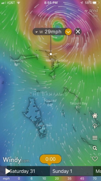
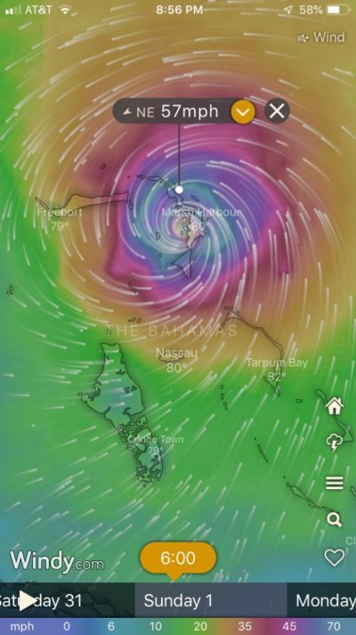
Yeah big difference between European and GFS models. Amazing what difference a few miles makes.

GFS
IMG_6777.jpg

European
IMG_6778.jpg
 
SMILE
This thread is beginning to sound like the local TV news stations. Doom, gloom and you are all gonna die. LOL
 
I know. I gotta stop. [emoji30]
 
Movement slowed again, from 14kts to 11kts now and another half day added over water before it hits shore.
 
I swear. I feel like a hurricane magnet.
I know. I gotta stop.
emoji30.png


Don't worry , be happy , this time your roller jib is stowed.
 
Lets remember this is a relatively small hurricane. By small I mean hurricane force winds extend only 15 miles out from the eye. Of course this can change in an instant. Storm surge is more concerning for me. My marina can take about 12 feet. It took 8 feet with Matthew. We have a super moon Friday. Hopefully tides will go down before Dorian hits. Looks like a Monday hit at this point coming in as a cat 3. Where it will hit is still not predicted no matter what the news may say. ALL of Florida is in a state of emergency. The national guard is on standby as are power company’s and other emergency services.

A practical tip is, remove your boat paper/folder, etc. you made need it to gain access to your vessel after the storm passes.

We all love our boats, I know I do. Southerly is protected and insured. What happens, happens.

Be safe my fellow Florida boaters!
 
I swear. I feel like a hurricane magnet.
I know. I gotta stop.
emoji30.png


Don't worry , be happy , this time your roller jib is stowed.

1 question and one suggestion
Where are you right now and if you are a hurricane magnet would you please move to Iowa or the State of Washington?
 
Last edited:
I swear. I feel like a hurricane magnet.
I know. I gotta stop.
emoji30.png


Don't worry , be happy , this time your roller jib is stowed.

They do seem to have been following your boat to any coast more than anyone else on this forum. At least they keep missing.
 
Yeah we did stow the jib before leaving. So there’s that. I do worry about my big solar panels up there in a big blow however.

Do you have any boats at the hurricane hole this year Fred?
 
"Do you have any boats at the hurricane hole this year Fred?"

You bet , the late to the party folks are anchored in Lollypop, as it has a fantastic sand bottom, the canal will be next to fill .

The big hassle for some may be the bridges refuse to open above 35mph or so.
 
I’m not familiar with Lollypop? Where is that?
 
Currently, the GFS (NOAA) is the outlier having it further north than the others. Slowing has delayed it's anticipated time coming to shore until during the day or early evening on Monday. The ECMWF and UKMET are the furthest south as they have it hitting around Boynton Beach. They're the ones for the Abacos to fear most. The consensus is still north of Vero Beach. Tomorrow and Saturday is when the models are likely to come closer together and increase accuracy.

At one time, I would have thought the ECMWF was the one to watch more closely, but the past couple of years and since some upgrades, the GFS has actually become the most accurate. Still, the best information now just says somewhere on the FL coast, between Boynton Beach and Daytona Beach.
 
I can get the 123 miles from here to my brother's WELL protected canal pier in Orange Beach, AL at the end of his canal behind his home and tie up to his GB42 with an anchor to a little lollipop island there pulling us both off the pier in eight hours. The problem with that during the runup to Micheal was that the time from initial forecast of cat one (in which I would take a minimal level of precaution with the boat moving to a safe anchorage) to the OMG it's a cat four was just about overnight. I began my usual fueling operation to get enough on board to get to his home, well clear of the now narrow cone of impact, by hauling off-road diesel to the boat in its lift out behind the house in five-gallon containers on which I have ten with fuel obtained from the local gas station. By the time I was done, a few realities struck home. It was going to be dark by the time I got there, and while that did not bother me, having my wife hazard a trip over there on I-10 could have very well found her stranded there in a gigantic traffic jam as people fled the area. With my single engine, a propulsion malfunction could have stranded me in the middle of nowhere like out in the middle of the 23-mile long Chotawhatchee Bay with the very likely scenario that BOATUS wasn't going to deploy. With all going to plan, getting back home a 2-3 AM on the day the storm hit here at 9-10 AM would have been a non-starter. While fueling, I had made a call to a friend with a canal home about 5 miles distant, and in the end I elected to go there. Even then, at less than 24 hours until landfall, the uncertainty of which direction along the coast from here it would hit left me with no idea of whether to point the bow east or west in the E-W oriented canal; I chose wrong. With no more vulnerable trees to fall across that canal, I might go there again for Dorian, but there are still days to contemplate any move. If it is to Orange Beach, I will leave here Saturday early in the AM.
 

Latest posts

Back
Top Bottom