Surviving the Fire Island Inlet

The friendliest place on the web for anyone who enjoys boating.
If you have answers, please help by responding to the unanswered posts.

Mike GB32

Senior Member
Joined
Oct 18, 2018
Messages
158
Location
USA
Vessel Name
Giddy II
Vessel Make
1974 Grand Banks 32
I am trying to overcome my fear of the Fire Island Inlet (New York). I made the mistake of trying to venture out of the Great South Bay at the end of last season and immediately ran aground. Luckily, I was able to continue back inside but was I shook!
I've done a little research and it seams like its possible to share recorded tracks on the Navionics app. I've never done this but I'm wondering if anyone who has recently been through the inlet might be able (or willing) to share the track? Would it be possible to post the track here on the forum that could be downloaded onto my iPad?? Does it even work that way? I'm not talking about a picture of the route. I'm talking about a GPX file.
Obviously my technical knowledge is limited.
Thanks in advance.
 
Last edited:
Where did you run aground? Looking at the inlet there does appear to be a note about shifting depths just inside the inlet, but the buoys should be moved to reflect good water.

I would focus on staying between the buoys, not someone else's route that worked before. It may not work now.

David
 
The way I understand it is: there is constant shoaling in the inlet and the buoys are unreliable. I was following the buoys when I ran aground.
 
The way I understand it is: there is constant shoaling in the inlet and the buoys are unreliable. I was following the buoys when I ran aground.

Then following someone else’s year old track will probably be worse than following the buoys. Unless you get a contemporary track you might want to follow someone else going through that shifting stretch.

David
 
Yup.
Agreed.
That's why I was for help from someone who has been through recently.

I even thought of jumping on one of the party boats (charter fishing) that might go out there and bring the iPad to record the track myself.
 
Last edited:
If you have an assistance tower in the area, you might try calling them for guidance.

When I was one, the USCG sked me for my thoughts on where they should move the buoys.
 
I grew up on Long Island and use to drift fish the inlet. When transiting the inlet to the ocean we simply followed the markers and never went aground. I would call the Coast Guard and confirm the markers locations are current.

John
 
Agree with PS in talking to the tow boat operators in the area. They are probably in and out most every day.
 
I am trying to overcome my fear of the Fire Island Inlet (New York). I made the mistake of trying to venture out of the Great South Bay at the end of last season and immediately ran aground. Luckily, I was able to continue back inside but was I shook!
I've done a little research and it seams like its possible to share recorded tracks on the Navionics app. I've never done this but I'm wondering if anyone who has recently been through the inlet might be able (or willing) to share the track? Would it be possible to post the track here on the forum that could be downloaded onto my iPad?? Does it even work that way? I'm not talking about a picture of the route. I'm talking about a GPX file.
Obviously my technical knowledge is limited.
Thanks in advance.

I don't know that water but I'll throw this out there.

You are obviously cautious. But I know a guy who was persuaded to give Moriches Inlet just up the coast a try. He felt he had obtained good local knowledge. Somewhere inside the inlet he hit a bar at 18 knots. He had hands on the wheel and managed the impact, but the other 3 aboard were hospitalized, one seriously. He has decades of experience, but I don't know what made him feel OK with that speed.
 
Shoaling inlets are a big problem on the East coast and getting worse. I would consult with the local USCG but with a grain of salt since they depend on the most recent aerial and sounding reports which are not always timely and accurate hence their constant inlet warnings. The old timers used to say asking a salvor for passage info was like asking a house dealer which card to play. TowBoat is probably above board but I’d place my life and my boat on how commercial or head/ party boats run inlets. No head boat operator is about to risk his passengers, boat or license so if they run an inlet they know the shoals. If they don’t run neither should you. From the outside it’s blind so unless you can watch outside the break and it looks doable you may be okay otherwise wait it out or move on.

I’ve entered some tricky inlets from the Merrimack River in MA to Little Egg and Shark River on the Jersey coast and Oregon and Okracoke inlets on the NC banks alway by following the locals. Watching high speed planing hulls doesn't count. However having a decent turn of speed is your friend with shoaly inlets and remember what was safe three days ago may not be today. No experience with Fire Is. so sorry I can’t give you good info.

Be careful and hedge your bets.

Rick
 
I went thru the Fire Island Inlet Aug 25 with my boat. Its a 26 Grady White twin outboards. Going out (at 1 PM ) the minimum depth was 3.8 FT. It was almost dead low tide. ( 8/25/22 Low tide was 12:51pm Height was .37 FT. High tide 6:56pm with a height of 2.95 FT.) Coming back in at 4:14pm with a height of 1.73 FT. The minimum depth that I saw was 5.2 FT.

Here is the tracks that I took going out and in.
 

Attachments

  • Fire Island Track Aug 25 2022.gpx
    129 KB · Views: 62
I transited Fire Island Inlet this past June. I have a single engine diesel that draws a little under three feet. It was scary.

Buoys are absolutely unreliable in my opinion. I confirmed this by calling TowBoat US prior to leaving. Advice they gave me was to leave on the outgoing just before high tide. They said to stick close to the eastern side. Reverse this to enter of course. Buoys were way off. There can be a fair bit of current in the inlet as well. I got out fine, but it was white knuckle the whole time.

I stopped off at Freeport, I thought Jones Inlet was much easier and safer to navigate. I think I will use Jones next time and take the channel eastward.

Although I have the track I'm not going to share it as I think the inlet could have changed since then.

My two cents.

-martin610
 
I went thru the Fire Island Inlet Aug 25 with my boat. Its a 26 Grady White twin outboards. Going out (at 1 PM ) the minimum depth was 3.8 FT. It was almost dead low tide. ( 8/25/22 Low tide was 12:51pm Height was .37 FT. High tide 6:56pm with a height of 2.95 FT.) Coming back in at 4:14pm with a height of 1.73 FT. The minimum depth that I saw was 5.2 FT.

Here is the tracks that I took going out and in.

This is EXACTLY what I was hoping for! Thanks for taking the time to post it.
With just a couple of clicks I was able to download and display the track on Navionics on my iPad. My boat has a deeper draft but the information you gave regarding time and tide could help me immensely.
To everyone else who replied- thanks a ton for the input.

Shouldn't there be a place here on the forum to share tracks like this?
Maybe another post...
 
Fire Island Inlet et. al.

We moved to Lindenhurst NY on Great South Bay in 2015. It is a far cry different from the coast of Maine! LOL

I can attest that shoaling conditions ARE always changing in all the Inlets.

The worst, most challenging, area IMO is Moriches whose East-West inside passage is practically non-existent except with local knowledge along a non-intuitive and non-marked route.
Moriches was opened up by dredges a few years ago, but it never stays open. The advice there is to call Seatow or TowboatUS and offer them a "tip" for an escort through... (either the EW inside passage or to make the inlet itself. I have no idea what a reasonable tip is, but it is probably more than $20.
Capt Arne of Towboat US mobile: 631-281-1246 will help you. Another landline number is 631-281-2017 for his dispatcher.

Jones Inlet used to be the busiest and most reliable, but I saw in the notice to mariners last spring (as we were finishing our Loop) that it was all shoaled up. It seems to open now due to the dredging efforts last spring. Last spring (May 6, 2022) we simply avoided it and used Far Rockaway Inlet which is closer to NJ and NYC anyway. I've never had a problem in Far Rockaway Inlet. (It has another name too, but it escapes me right now). Watch for updates to this post. EAST ROCKAWAY INLET... (there is another name too.)

Most recently: We came IN at Fire Island Inlet on Monday August 29, 2022... skipping Moriches as we normally do... making the 50 mile trek from Shinnecock to Fire Island Inlet, as we finished our New England tour and are now starting our way south to FL. Fire Island Inlet IS marked, they do move the buoys around, but it is not always 100% clear honestly. It is always nice to have a tour boat to follow in or out. Good luck with timing that.
For that passage, we timed it horribly at low tide bucking the current coming out. We saw 4.5 feet in critical places, not much room for error but never touched. Reading the breakers is always an art. Because of many factors we really did not have many other choices for our Shinnecock to FI inlet timing. Over the years FI Inlet has never been a problem spot for us, but our 8/29 passage was the least comfortable of all of them... but not unsuccessful even at low tide. (We draw 3.5 to 4')

My experience with sharing "tracks" files are you'll get several hundred (thousand?) miles of track unless I do the onerous task of starting and ending every passage. Not a ritual I am going to add to our beginnings and endings. That information is questionable anyway as others have pointed out.

We are currently anchored in Bannister Bay / aka Lawrence NY ... a fantastic anchorage (and marina) which we have used many times to begin our treks to NJ, NYC, etc. It is right next to Far Rockaway Inlet... Our Loop started and ended here in May 2021 and May 2022. It is a favorite Inlet and favorite anchorage. We've been here for several days waiting for the seas to subside (Hurricane Earl's influence). I now may have some customers to visit before we head south. So, who knows when we'll be underway this week.

Hope the recent details help. There are more details on the blog... whose Search tool works pretty well.

Ray
Shellerina [.com]
 
Last edited:
Where did you run aground? Looking at the inlet there does appear to be a note about shifting depths just inside the inlet, but the buoys should be moved to reflect good water.

I would focus on staying between the buoys, not someone else's route that worked before. It may not work now.

David

Most of the time I would agree, but not in the Fire Island Inlet. Leaving on our trip back in early July I noticed at one point a depth of only 5 feet within the buoys. Looking at the color of the water you could tell where the shoaling had taken place (again, all within the inlet buoys). On my return a month later, I did follow a fishing boat in, which took me off my normal course but worked out.

It is not the first time. Some years back I delivered a 50-foot sailboat to Newport from Bay Shore. When leaving the FI Inlet, we went aground (soft) and were able to back out (very calm day). I radioed a local BoatUS to get some advice. He told me that the Captree fishing fleet at the time was staying east of the red buoys, totally outside if the channel. Drawing 6 feet in the boat I was on; I did the same and we made it out.

FI Inlet does shoal. The Coast Guard isn't always able to move the buoys as needed. So local knowledge does come into play. I suggest also contacted the local BoatUS or SeaTow for assistance.

Again, I would normally agree as I am one who certainly will follow buoys over a plotter. Unfortunately, in FI, as well as many other east coast inlets prone to shoaling the buoys aren't always trustworthy.
 
I am trying to overcome my fear of the Fire Island Inlet (New York). I made the mistake of trying to venture out of the Great South Bay at the end of last season and immediately ran aground. Luckily, I was able to continue back inside but was I shook!
I've done a little research and it seams like its possible to share recorded tracks on the Navionics app. I've never done this but I'm wondering if anyone who has recently been through the inlet might be able (or willing) to share the track? Would it be possible to post the track here on the forum that could be downloaded onto my iPad?? Does it even work that way? I'm not talking about a picture of the route. I'm talking about a GPX file.
Obviously my technical knowledge is limited.
Thanks in advance.
Just follow one of the head boats out in the morning or afternoon. They leave from Captree.
 
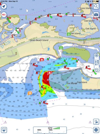
9E8BA397-4629-42B9-8180-A42F92438720.jpg

See attached file. Army COE underwater survey of Fire Island inlet
 
I even thought of jumping on one of the party boats (charter fishing) that might go out there and bring the iPad to record the track myself.[/QUOTE]

Better then jumping on one, just follow one in and out

I often go to unknown harbors. Piggybacking a similar sized/draft boat is priceless. Still look at charts etc… (dont follow blindly, lol) but makes for a more pleasure-able experience

I save all the stress for when i have to “raw dog” coming in to a new harbor in bad weather or off hours.
 
Last winter The dredge was set up . I saw it every day but there was very little movement . Turns out Piping Clovers were nesting and they shut down. Over $12m wasted
 
Well, I started the thread so I thought I would follow it up by sharing what eventually happened.
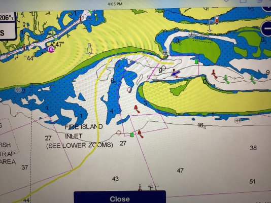
I called Tow BoatUs the day before. They told us that the best advice they could give was to do what some folks here suggested and follow a party boat out. We finally took off on our trip south yesterday. We got behind the first party boat out and did our best to follow. He was much faster than the 4 to 5 knots that we could muster in the current. The route that we took completely disregarded the bouys- following the shore west then heading south between two sand bars. Helluva ride for this novice. White knuckle for about 25 minutes.
I do believe I’ll be coming back via the Jones Inlet!
C2D40B5F-1A92-4E8F-AC46-5E647E9EB8A3.jpg
 

Latest posts

Back
Top Bottom