Navionics Boating app no longer shows current station

The friendliest place on the web for anyone who enjoys boating.
If you have answers, please help by responding to the unanswered posts.

ScottRhodes13

Member
Joined
Nov 16, 2021
Messages
22
Vessel Name
Wanda June
Vessel Make
Atlas Pompano 21
Hello all,
I've just noticed that the Navionics Boating app on my Android device no longer shows the current stations at Deception Pass, or anywhere else in Skagit Bay. Does anyone know if this is just an oversight or will they no longer be displaying this information?
 
Just checked two Android devices. Neither show currents for Deception Pass and Skagit Bay. Another reason to not fully trust Navionics.

Currents are shown fir nearby areas.
 
This is something to try. A stab in the dark. My Navionics wasn’t working any longer on my Apple devices. I deleted the app from my devices and reloaded them (they remained in the cloud). Now they work. No explanation, just something to try.
 
I have Navionics on an I-pad Pro. I am also,showing no current data at Deception or several other places where it would matter.
 
Well, I've sent an email to Garmin. We'll see what they say. Thanks, everyone, for verifying that it wasn't just me.
 
Tide data for that area is puliing up just fine on my iPad. Not so the current forecasts.

After passing through many areas in BC, WA and AK over the years I've found, when applying a bit if logic, strong correlation between tidal data and currents. I don't always trust the software calculated single point currents as much as reading both tidal graphs and nearby current forecasts. BC does a good job on their annual predictions if one takes the time to read through the correlation data.

Seymour Narrows is a good example, those tide and current forecasts control a wide swath of water when applying time and distance "formulas."

So, for smoothest ride through Deception Pass, does slack tidal timing and analysis of the several nearby tidal locations perform OK?

The current data has always served me well, so I haven't tried to analyze any correlation between the tide and the current. The problem in Deception Pass is that a small error in your guesstimate can result in a 3 or 4 knot difference in current. Also, the pass is used by many non local boaters, who can't be expected to be familiar with the correlations.
 
Tide data for that area is puliing up just fine on my iPad. Not so the current forecasts.

After passing through many areas in BC, WA and AK over the years I've found, when applying a bit if logic, strong correlation between tidal data and currents. I don't always trust the software calculated single point currents as much as reading both tidal graphs and nearby current forecasts. BC does a good job on their annual predictions if one takes the time to read through the correlation data.

Seymour Narrows is a good example, those tide and current forecasts control a wide swath of water when applying time and distance "formulas."

So, for smoothest ride through Deception Pass, does slack tidal timing and analysis of the several nearby tidal locations perform OK?


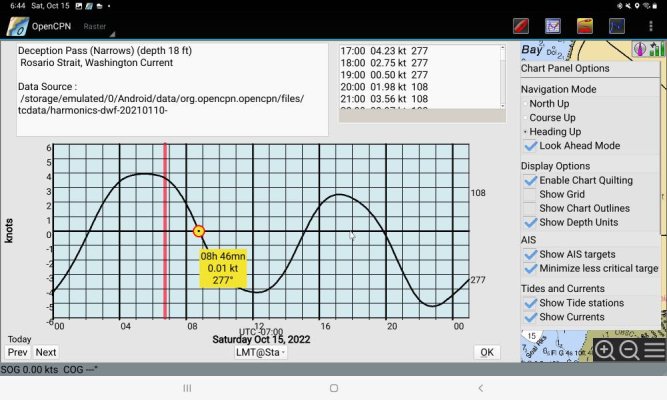
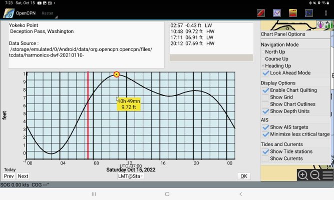
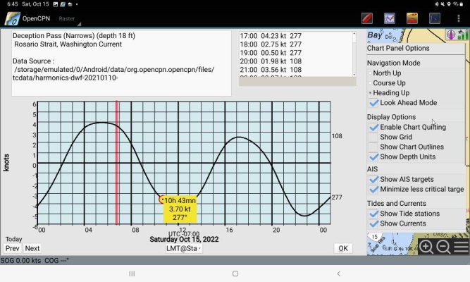
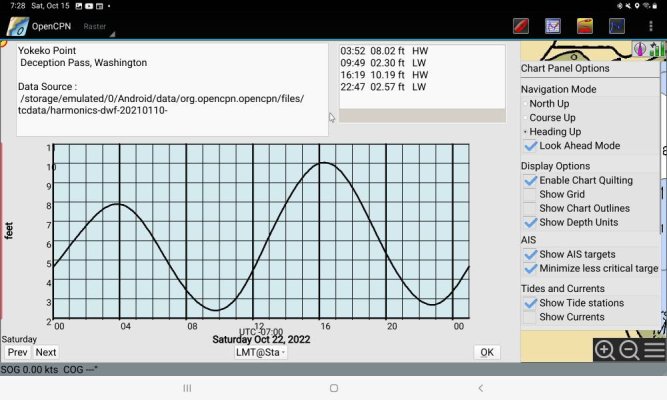
No, looking at Deception Pass nearby tidal height stations does not help to predict smooth passage. Looking at this morning's current data for Deception Pass the early minimum current is at 08:46 local. I'm using the term miniumm current because there is no true slack in Deception Pass Narrows. The nearest tide height station in the areas of strong currents of Deception Pass is Yokeko Pt. showing a max tide height at 10:49 local, 9.72 ft. At that time the current in the narrows is 3.77 ebb. Looking at the tide height graph of Yokeko Pt it would appear with the small change to higher low then to lower high that tranisting Deception Pass between 10:49 and 20:23 local would be good. Going back to the current graph the unwary mariner could expereince currents as high as 4.34 kts. 4.34 kts may not be a big problem unless it is an ebb, which it is, and the afternoon westerly has started.

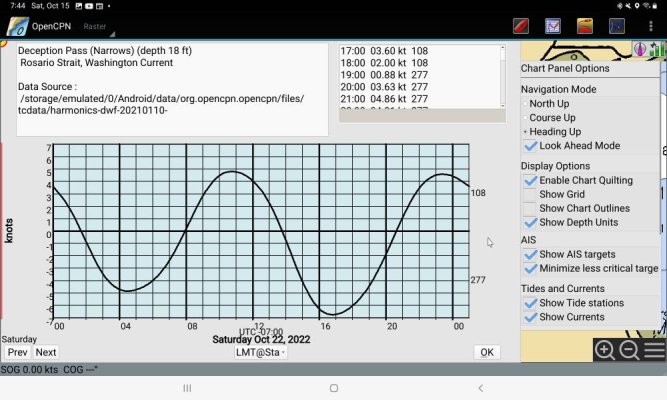
However today's tidal exchange is not as big as it can be. When I look at a day with bigger tidal exchange the problem gets bigger. For exmple Oct 22. Trying to use tide height could lead the mariner to attempt a 6.7 kt ebb. The mariner will experience whirlpools, boils and possibly standing waves.

I'm using OpenCPN for this discussion because that and Navionics are what are loaded on my tablet. And Navionics data are missing.

I have found that for many high current areas the time difference between max or min height and max or min current are significantly different. Sometimes enough to cause problems.

This is a prime example to use more than one data source. In this case the data are missing from Navionics. I have also found inaccuracies in predictions for such areas. Not just Navionics.

Narrows%20current%20221015.jpgYokeko%20height%20221015.jpgNarrows%20current%202%20221015.jpgYokeko%20current%20221022.jpgYokeko%20height%20221022.jpg
 
PB
Good points, thanks. If Navionics didn’t exist, (which didn’t 50 years ago) how would a boater get through there? Thousands did including me.

My take is there are strong floods and ebbs to deal with at DP. It is not the only passage that applies. Winds confuse things too., at times building up the seas.

Old school maritime skills and alternative data, as you point out, are good to have when our subscription to Navionics plays out.
 
I have nothing to add other than I'm grateful the majority of our boating (Chesapeake, US mid-Atlantic) never needs to care about tides and currents!
 
PB

Good points, thanks. If Navionics didn’t exist, (which didn’t 50 years ago) how would a boater get through there? Thousands did including me.


My take is there are strong floods and ebbs to deal with at DP. It is not the only passage that applies. Winds confuse things too., at times building up the seas.


Old school maritime skills and alternative data, as you point out, are good to have when our subscription to Navionics plays out.
I've been runing through Deception Pass since the 70s. NOAA tide and current tables were how we used to do it. That's still the best tide and current data on US waters.
 
I have no experience in Puget Sound but plenty , yet not expert, in B.C Waters.

Tide states and current states do not always coincide with each other. THere can be an hour or more difference between them.

Generally, the bigger the tide change the greater the time difference. People who depend upon the tides to determine when to transit a pass with strong currents are asking for trouble. If not today then someday.

We learned some years ago to not trust Navionics for this kind of info.
We had done our calculations for the passes we were transiting and they DID NOT coincide with the Navionics. We trusted out calcs. We both do them and if there is a difference in timing of more than a few minutes there is further discussion. THe one time we failed to each do independent calcs. was the time we goofed big time.

I wonder if Garmin, Navionics, realized there was a problem between tide timings and current timings and were not willing to fix the problem, at least not yet so canned those predictions from the updates.
 
Here's the reply I received after contacting Navionics:

Thank you for reporting the missing prediction data. We are constantly reviewing our data to ensure that is as accurate as it can be. During a recent review, we found the tide prediction data in this area to not be as accurate as we would like it to be, and as a result made the decision to remove it. We understand that this will impact customers like yourself, are working to improve and restore data in this area as soon as possible, and apologize for any inconvenience this may cause.

 
Product liability. Provide useful information? Someone will figure out how to wrangle a big settlement out of a perceived omission by the provider.
 
In a half-arsed way that's a responsible position from Navionics. If the data are known to be wrong especially when the risk is high then don't display the data. OK as far as that goes. But the NOAA current predictions for Deception Pass are very accurate. Skagit Bay is another story. It seems to a challenge for NOAA or anyone to accurately predict currents.
Here's the reply I received after contacting Navionics:

Thank you for reporting the missing prediction data. We are constantly reviewing our data to ensure that is as accurate as it can be. During a recent review, we found the tide prediction data in this area to not be as accurate as we would like it to be, and as a result made the decision to remove it. We understand that this will impact customers like yourself, are working to improve and restore data in this area as soon as possible, and apologize for any inconvenience this may cause.

 
I have experienced several issues with navionics on Apple and Android devices this summer (had been using it for 3 previous years without any issues). They were not responsive or interested in understanding the real issues. I sent them screenshots and such. All they offered is to update the app and download a fresh copy of hand maps. Did all that twice with no change.

I ended up downloading the Simrad navigation app which is C-map. It does getting use to but worked fine.

My navionic chip in the MFD worked perfectly. I am thinking of going with the desktop version of Time Zero for next season. Using a Surface Pro on the Flybridge for that.
 
Definitely “Buyer Beware” on this. FWIW, AyeTides seems to provide forecasts for Deception pass.

For situations where a transit of a tidal pass is challenging I always consult the Agency Tables: CHS in Canada and presumably NOAA in the US. For example I have a spreadsheet for the Yacultas, Gillards and Dents that accepts inputs from the CHS reference stations. Lately it matches the Coastal Explorer tables but in the past it wasn’t always so.

Jim
 
The closest NOAA current station is Yokeko Point, and their tables and plots provide predictions. What’s interesting is that the other Garmin product, Active Captain, does display current data.
 
The closest NOAA current station is Yokeko Point, and their tables and plots provide predictions. What’s interesting is that the other Garmin product, Active Captain, does display current data.

But is it any better than what the Navionics app used to provide? Because if it's 'just as bad' then that's not much help either.
 
Well, it’s the best data NOAA has.
 
Well, it’s the best data NOAA has.

I was speaking more in terms of how the Active Captain interface showed it, not the NOAA site itself, if that wasn't clear.
 
I was speaking more in terms of how the Active Captain interface showed it, not the NOAA site itself, if that wasn't clear.

Even more interesting: after a couple hours, I went back to Active Captain intending to grab a screen shot of the nice current plot I had seen earlier. Now, the current station link is gone from here. I guess Garmin is going for consistency across their product line, if not utility.

If the apps just grab and display NOAA data, I think that’s a good service and all you should expect. Any interpolations to get tides or currents nearby is up to the navigator. I don’t know why Garmin would back away from this as that is a current station showing on the NOAA tables. On the other hand, if they were trying some fancy interpolations, there could be liability issues there.
 
Even more interesting: after a couple hours, I went back to Active Captain intending to grab a screen shot of the nice current plot I had seen earlier. Now, the current station link is gone from here. I guess Garmin is going for consistency across their product line, if not utility.

If the apps just grab and display NOAA data, I think that’s a good service and all you should expect. Any interpolations to get tides or currents nearby is up to the navigator. I don’t know why Garmin would back away from this as that is a current station showing on the NOAA tables. On the other hand, if they were trying some fancy interpolations, there could be Lia I pity issues there.
I wondered about them taking it out of one product (for the reasons they offered) but leaving it in another.

Likewise, calculating the currents in a manner useful to the novice boater, for the area in question, does seem to be something where liability would be a concern. I wonder if there was a specific situation/problem that happened to lead to this removal?

I don’t know. It’s a well known potential hazard area. And, the current station location, while certainly not reflecting the magnitude of currents through the pass, which has significant narrowing, should pretty accurately reflect the phasing of the current. So if you’re looking for near slack, that should provided it pretty well.
 
This is something to try. A stab in the dark. My Navionics wasn’t working any longer on my Apple devices. I deleted the app from my devices and reloaded them (they remained in the cloud). Now they work. No explanation, just something to try.


That sounds like the old "unplug it and plug it back in." It seems that these systems need an occasional reboot. Not just Navionics but anything computer related seems to benefit from it.
 
I just pulled up (free) “tidesnearme” for DP and it has tables for currents showing the next slack for Monday AM at 9:36 AM. This site is one of many showing DP tide and current data.

It would seem the real issue is not unavailable current data for DP but rather displeasure with Navionics and associated fees one chooses to pay.

Yes, there are alternatives. But I've found the current tables in the Navionics Boating app and on my chart plotter to be really convenient when planning a trip or when approaching Deception Pass at an unplanned time.

I don't mind paying a few bucks every year for the boating app, but I'm pretty unlikely to purchase an updated chart for the chart plotter until the current tables are back.
 
For those still interested, I’ve been digging into the Active Captain and Navionics apps to help prepare a Power Squadron seminar on electronic navigation in the Salish Sea, and happened back to Deception Pass. Suddenly, both apps again have current data for Yokeko Point (just east of the Pass). Odd?
 
Back
Top Bottom