Forward looking transducer? Do they work?

The friendliest place on the web for anyone who enjoys boating.
If you have answers, please help by responding to the unanswered posts.

boating rich

Veteran Member
Joined
Jul 8, 2018
Messages
92
Location
usa
Vessel Name
Oriente
Vessel Make
Back Cove 37
I am shopping transducers and ran across the garmin panoptix ps51-th livevu forward transducer. It lets you see forward into the water the boat is heading into. It is $1400 so not something to just buy and try. It has been out for seven years but I can find any reviews of it. I can see it working for finding the way through shallow water and for scanning 360 degrees around your anchor to make sure you swing is clear of obstructions. It sounds like magic. Does anyone have any experience with this?
 
I heard at trawler speed you have time to stop if you are paying attention before you hit.
 
Typically forward visibility is limited to 8 x depth and even at that, it’s not as clear a picture as one might get in a modern standard sounder.

Ken
 
We had a Sitex on our last boat. It worked but did not have very good range. I could only get about 50-100 ft out of it when looking ahead.
 
I Had the Garmin panoptix on my last boat for fishing and got about 125 ft of good images in salt water that did not have silt in it.
 
I am shopping transducers and ran across the garmin panoptix ps51-th livevu forward transducer. It lets you see forward into the water the boat is heading into. It is $1400 so not something to just buy and try. It has been out for seven years but I can find any reviews of it. I can see it working for finding the way through shallow water and for scanning 360 degrees around your anchor to make sure you swing is clear of obstructions. It sounds like magic. Does anyone have any experience with this?


I had a Simrad package installed in my new build last summer. I got their version for the use case you describe. I really didn't get out on the water much until August as things got squared away. And have not yet had the circumstances you describe.

It shoots at an angle forward. So the distance ahead is longer in deep water than shallow. I expect it to be helpful when depths go from reasonably deep to a shoal. But when going from very shallow to too shallow the vision forward won't be much. The angles.

And yes, I'd say its best use is when picking your way forward when your charts are already telling you caution is needed. At trawler speeds there would not be time to detect a problem ahead and stop or veer.

I wish I could be more precise based on experience. Too soon to know.
 
I have the Garmin PS51 and have used it for the past 3 years in Southeast Alaska. It is indeed very valuable for scouting anchorages. You can see easily shoals, rocks, and abrupt bottom changes. As you mention you can also rotate the boat and scout for changes in depth around a potential anchorage. I do not enter an anchorage without monitoring it closely.


I usually operate it in what is called "bottom fill" mode, where the display shows solid below where the transducer "thinks" the bottom is. The only time this doesn't work well is when there is a lot of vegetation in the water, in that case I turn off bottom fill and use the raw display to identify the bottom.


The forward looking sonar is also useful when deploying and weighing the anchor. You can see the anchor touch or leave the bottom, you can also see the angle of the anchor rode as you approach or back-off from the anchor.


I would not have another boat without this or a similar system.
 
Thanks Folks. It seems like this is something I should pass on and save the money. I had not thought about the depths. Most of the areas on the icw are 8 feet and less which wouldn’t help.
 
I have the Garmin PS51 and have used it for the past 3 years in Southeast Alaska. It is indeed very valuable for scouting anchorages. You can see easily shoals, rocks, and abrupt bottom changes. As you mention you can also rotate the boat and scout for changes in depth around a potential anchorage. I do not enter an anchorage without monitoring it closely.


I usually operate it in what is called "bottom fill" mode, where the display shows solid below where the transducer "thinks" the bottom is. The only time this doesn't work well is when there is a lot of vegetation in the water, in that case I turn off bottom fill and use the raw display to identify the bottom.


The forward looking sonar is also useful when deploying and weighing the anchor. You can see the anchor touch or leave the bottom, you can also see the angle of the anchor rode as you approach or back-off from the anchor.


I would not have another boat without this or a similar system.


That does make sense. They show people fishing and they can see their jigs so seeing your anchor rode should be doable. Thanks
 
Follow up question. Do you need a second transducer for when you are at speed? They seem to say it only works up to 8 knots?
 
Follow up question. Do you need a second transducer for when you are at speed? They seem to say it only works up to 8 knots?

I only monitor the forward looking transducer at very slow speeds, less than 3 or 4 knots when entering an anchorage or a harbor. I don't see the value at cruising speeds where I am typically in very deep water. I just use the standard downward looking transducer when cruising. I change to the forward display when I get in less than 100' of depth.
 
My brother has the Simrad system and it seemed to be a good purchase as he boats mostly in San Francisco Bay which can be very shallow and there are places you need to stay in the channels. He finds it very hard to actually take advantage because of difficulty in understand what he is seeing at his travel speeds. I could see the advantage of being able to see your anchor and anchorage surroundings slowly.
 
Follow up question. Do you need a second transducer for when you are at speed? They seem to say it only works up to 8 knots?

In my Simrad only one transducer can be run at a time. I also have a medium chirp for basic depth. On the MFD there is a side panel one can leave up (and I do) displaying speed, fuel burn, etc. The depth there has to come from chirp.

In an exchange somewhere recently with someone who had Garmin they said Garmin didn't have that limitation. You can run both.

If you don't need to know depth under you I suppose you could just use forward. I'd think at anchor you would want depth as you drop the hook to know how much chain to set with desired scope.
 
I have had a Panoptics on my boat for the last 4 years and love it. I use it for exactly what you want it for. Keep in mind it’s only designed to see 300’ down and 300’ forward. I keep mine set at 150’ forward and have bottom fill on. I always flip my GPS to sonar when entering know shallow areas, marinas and/or anchorages. After using it for this long, I wouldn’t have a boat without it.
 
We also have the PS51 on Jubilee and I use it to sniff out the shoals when going slowly into tight places. The picture shows a typical display when slowly underway. You can see that we are showing 34.2 feet under our keel and the beam goes out forward about 105 feet with a pretty flat bottom. The beam is twenty degrees wide. There may be some fish near the bottom at a depth of 22 to 27 feet and about 30 to 40 feet out. I am still leaning this system and I am looking forward to experimenting more with it this summer.


Here is a ten second video of this:


Attachments

  • 20230718_092849.jpg
    20230718_092849.jpg
    70.2 KB · Views: 21
Stern mounted is easy and works.

I can get accurate reading yet reduced underway. I have charts for forward movement. I installed a new Garmin with hardline to aft mount protected by swim platform. It’s a good idea.

34’ CHB 1981 tri cabin Sausalito
Douglas
 
I am happy with my Garmin but I only use it when I am entering strange tight passages or anchorages going slow. Doesn't work well at higher speeds.
 
I had an Interphase unit installed on a previous boat and it worked great. It was very useful when entering shallow waters and avoiding rocks etc that could be a problem, always going slow when doing so, less than 4 kts. Underway at 8 kts it worked well but not needed when you know the depths are good for your course.
It was the only electronic device I've purchased that increased in value after I bought it. Purchased for 1200.00 and 5 years later it was over 2000.00 and the model was the same. They were first on the market for the recreational boater.
Also the colour chart plotters etc are all a lot better now so the need for forward looking sonar is not quite as relevant to me as it was 30 years ago.
 
I have simrad NSO EVo3 with forward and down and side sonars. I love each for different reasons. Forward is great at slow speeds enter anchorages or looking spots to scuba dive, as is the side scan for going parallel to shore and looking for structure to fish or scuba. Down is great at 8-9knts for for cruise speed and trolling for fish.
 
I know this is an older topic, but perhaps my experience with a look-ahead sonar will be useful.

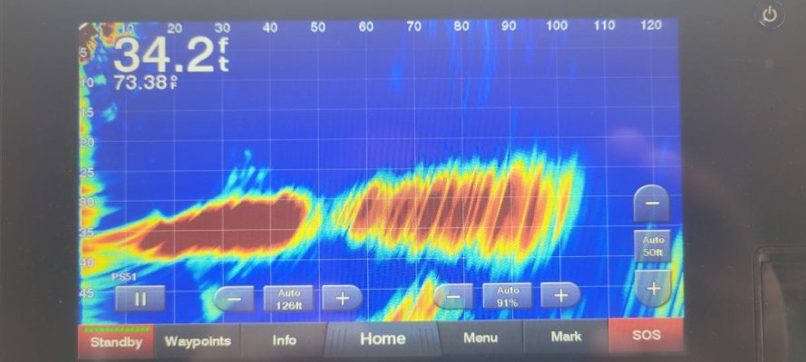
In planning our trip from down from the upper Hudson River to South Carolina (about 800nm), I knew we would encounter shoaling in the ICW, particularly opposite the inlets. Having run aground before and never having enjoyed that experience, I purchased the Forward-looking sonar head for my boat, linked to my new Simrad MFD. In addition, I followed the blogs and forums regarding this shoaling, and obtained the latest recommended tracks for the ICE inlets from Bob423.

Here’s what I found:
1. Most of the inlets have nowhere near the 12’ dredged depth that is charted. At least one had only 5’, which was nowhere near the charted or buoyed channel.

2. Some of the Bob432 tracks were helpful, but several were wildly off. That’s no reflection on the people who made the tracks, but rather the constantly changing nature of the inlets

3. Following the buoys near the inlets was maybe a 50-50 reliability. The Army Corps of Engineers is constantly dredging and the buoys are moved accordingly, but they sometimes cannot keep up with the silting.

4. At one inlet (I think Little River in SC) the tracks and buoyage was so far off, I relied on my forward-scan sonar to find my way through. Obviously the color of the water and viewing the water helped as well, but in a few instances it was touch and go

5. We took the Dismal Swamp and the Alligator-Pungo canals, and especially on the latter the forward scan was extremely useful There were numerous sandbars and floating logs on the Alligator-Pungo which you can barely see due to the dark waters. The forward scan showed me that on this canal you really had to stay in the center of the canal. There’s no markers or buoys for the most part on the canals

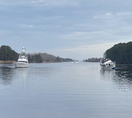
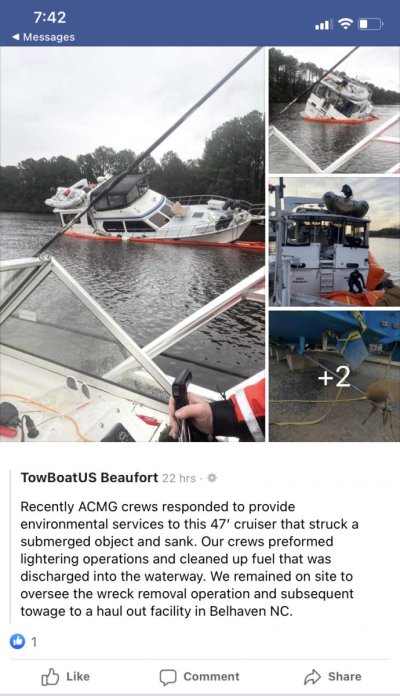
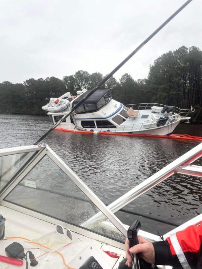
6. On the Alligator-Pungo, while doing about 6.5 kts we were passed by a 45 ft cruiser going at least 14 kts. As I saw him approaching us from behind, I tried calling him on the VHF asking how he’d like to pass me (so I could scoot a bit over) but no answer. He roared past on my port side, and as he waked us a voice comes over the VHF saying “Bye-Bye!”

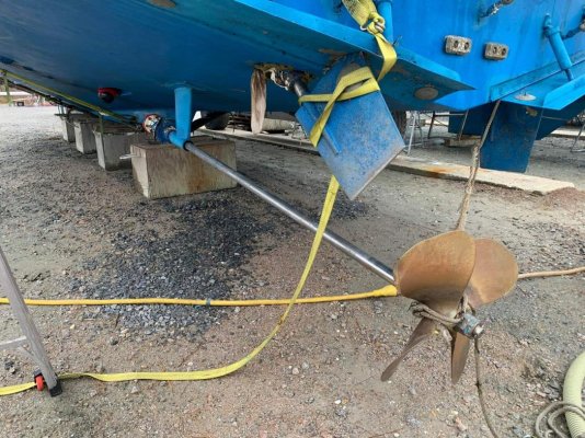
Well, he had gone about 1/2 mile when we saw that he had stopped on the left side (down bound) of the channel. When we got closer, this is what we saw. He had run right over a sandbar, ripping out his starboard prop shaft; the shaft with the drive saver pulled all the way out of the boat, stopped only by the strut. Left a gaping hole in the boat
 

Attachments

  • IMG_5685.jpg
    IMG_5685.jpg
    82.8 KB · Views: 28
  • IMG_5693.jpg
    IMG_5693.jpg
    84.1 KB · Views: 27
Wow. Can’t fix stupid.
 
It would be hard to resist saying “Bye Bye” back as you passed. Perhaps impossible to resist.
 
Thanks for the update. It sounds like the forward transducer did its job for you.

Side question. How did you find The Dismal Swamp for the depths and logs with the transducer? That place seems like it would be helpful given the speed.
 
It would be hard to resist saying “Bye Bye” back as you passed. Perhaps impossible to resist.

Actually, I didn’t pass him by as his boat was sinking and the owner (twit though he was) was in imminent danger. We called a Pan-Pan-Pan to the USCG, who asked me to stand by and report on what we were seeing. They would dispatch a smallboat from Elizabeth City, but also alerted BoatUS, who was much closer. I tried to nose in to take off the owner, who was alone and sitting on his stern platform. I called out to him and asked if he wanted to get off his boat, and he said he did. Seeing that his after cabin ports were open, and that the water would soon reach them, I told him to close the ports. He did not. Using the forward-scan sonar, I could see the sandbar he was sitting on. The closest I could get to him was about a boat-length from his stern. At this point the owner reappeared; I told him that I couldn’t get any closer to him, and suggested that he dinghy over to me ( his inflatable was sitting on the cabintop). Instead he went back inside. Meanwhile I was issuing Secuirite warnings to the other boats coming down the canal; these all were delivery captains, BTW. Several other boats attempted to get the owner off his sinking boat, but he refused. Well, the inevitable happened and the water reached the open after ports, and the boat lay partly on her side.

As it was getting dark, we asked to leave the accident scene, and since other boats were now on the scene they granted us permission. When we were nearing Belhaven, two TowboatUS boats were roaring up the canal

We learned later that the boat had hit the bar so hard that the entire port side propeller shaft, drivesaver and all, had pulled right out of the hull taking the stuffing box with it. Only the strut had prevented the shaft and prop from completely parting with the boat. The rudder was forced up into the hull, ripping another big hole. The following photos were taken by TowboatUS and by the salvage yard:
 

Attachments

  • IMG_5770.jpg
    IMG_5770.jpg
    126 KB · Views: 24
  • IMG_5765.jpg
    IMG_5765.jpg
    161.1 KB · Views: 17
  • IMG_5766.jpg
    IMG_5766.jpg
    201.9 KB · Views: 21
Interestingly, we saw very few floating logs in the Dismal, but I did hit one there: but we were barely doing 4 kts and it was so waterlogged it was probably 3’ underneath. It was a very gentle bump, no damage.

Where the scanning sonar really earned its keep was in the Alligator-Pungo. Lots and lots of sandbars, roots and semi-submerged logs. We had a good warning as we approached these, most of which to either side of the canal. The sandbars really freaked me out because the logs might yield to the hull and underwater gear, but the sandbars would show no mercy.

The passage behind the barrier islands of North & South Carolina was very sporty as we traversed the mouth of the inlets, or the area just west of them. Almost none of those matched the depths on the chart and/or the buoyage, and as we approached these I spilt the screen on my MFD to get a picture of the bottom. I believe I could see about 80’ ahead, which was fine. I actually went around the WRONG SIDE of a buoy because the shoal had shifted and the “dredged channel” had a sandbar right across it. I was waiting to be struck by lightning as we passed on the “shallow” side of that buoy! I’m pretty sure that was at Little River Inlet
 
Last edited:
That's a nasty failure mode. Normally I'd expect to see a pretzel shaped prop, bent shaft, maybe a snapped shaft and no prop, and maybe some rudder damage. But I wouldn't expect to see the entire shaft log torn out like that. It also appears the rudder post attachments were pretty weak and tore out of the hull without the rudder stock bending.

As an interesting note, the top aft corners of my rudders are rounded. I've always assumed it was to reduce the risk of a hull breach if you manage to bend one back like that. I'm pretty sure mine would also hit right on the metal hinge plate for the trim tabs, not against fiberglass (although the ones in the picture hit the trim tabs themselves, which would have been fine if the rudder had bent instead of tearing out).

Any idea what kind of boat that was that seems to be rather lightly built around the running gear?
 
It was a Heritage East 44, built I believe in 1987. Not a cheap boat! I think they had twin Cummins 6BTs
 
Last edited:
Your report is the best use case report on forward sonar I have seen anywhere.

Thanks for sharing.
 
I am putting in a Garmin Livescope transducer this spring mainly for fishing. The demos I have seen are impressive, at least in freshwater, where you can see fish swimming and with a resolution that you can easily identify a school bus on the bottom. This particular transducer has a 20 degree wide beam to port and starboard and 135 degree beam from forward along the bottom of the boat to 45 degrees aft as I understand it. I expect the keel will block some of the beam to port.

Tom
 
Back
Top Bottom