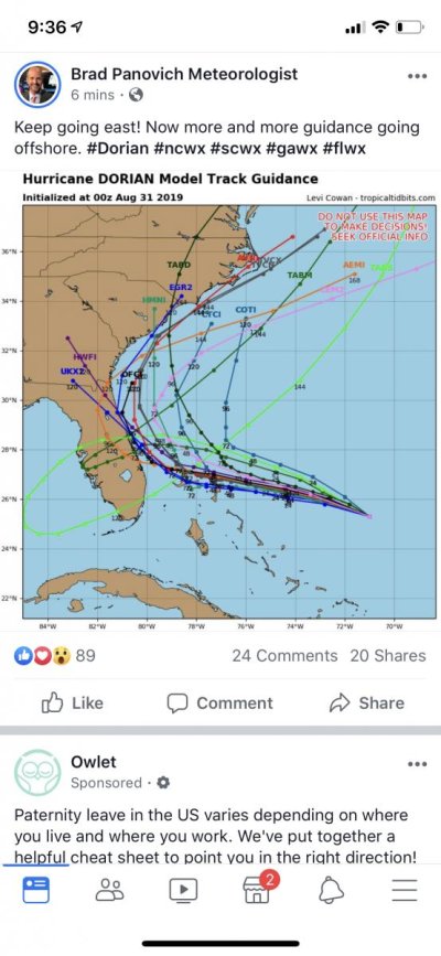
Dorian aims for East Coast of Florida

The friendliest place on the web for anyone who enjoys boating.
If you have answers, please help by responding to the unanswered posts.
WifeyB. I have about 40 open behind my boat at the dock. I see lots of captains eyeing that spot but the last hurricane I let a large cat tie up behind me for $200.00. He didn’t tie the boat properly and destroyed part of my dock, I repaired it for $6K and it’s much better now.
 
Last edited:
WifeyB. I have about 40 open behind my boat at the dock. I see lots of captains eyeing that spot but the last hurricane I let a large cat tie up behind me for $200.00. He didn’t tie the boat properly and destroyed part of my dock, I repaired it for $6K and it’s much better now.

Wifey B: The guy who was quoted the price had a 70' boat so $6300. He decided he was quite happy at Bahia Mar. :)

Yes, I know someone who at normal rates allowed someone to tie in Irma. They came loose and not only damaged his dock but a neighbor's dock. Then they refused to pay so the homeowner paid for the repair of his own dock and his neighbor's dock. :mad:
 
Sometimes it’s best to just be quiet after say sorry but no.
 
Spoke to guy with 30' sport fishing OB at my marina, he called a yard in Daytona to haul out a few days ago, $2,000 :eek:


Normal cost is $11-$12 a foot. or about $400 for this 30 footer
 
The damn thing is a cat 4 now. I bet it’s headed to cat 5. This is a bad one.
 
Spoke to guy with 30' sport fishing OB at my marina, he called a yard in Daytona to haul out a few days ago, $2,000 :eek:


Normal cost is $11-$12 a foot. or about $400 for this 30 footer

He could be in Fort Myers in a day?
 
Make that turn and stay east!!!!!
 

Attachments

  • C96AF9CA-164D-442A-B3AA-9F3D35F03B8F.jpg
    C96AF9CA-164D-442A-B3AA-9F3D35F03B8F.jpg
    98.5 KB · Views: 72
https://www.foxnews.com/us/hurrican...o-category-4-storm-as-it-heads-toward-florida

Its now Cat 4, ahead of time, and the track is uncertain, will hit any part of Florida from keys to Georgia. Hopefully will make a north turn and not actually make landfall. Bahamas to have a 15 foot surge.

What will be, will be. Heading south, you may not get south enough, and north who knows, it is still too soon to know where its going. You could move the boat right to where it comes ashore.
 
Last edited:
I hope tomorrow when I wake it’s turned north.
 
11pm update. I also looked at the NWC Wind Probabilities and they have all been decreased significantly since the last update.

Jax is 27% chance of winds to 34 kts, 15% to 50kts, and 5% over 64kts.

Nightie night!

* * * *

The hurricane is moving west-northwestward or 300 degrees at
9 kt. The ridge to the north of Dorian is expected to build during
the next 24 hours, and this should cause Dorian's heading to bend
westward toward the northwestern Bahamas. After 48 hours, the
global models show an erosion of the western portion of the ridge,
which is expected to cause the steering currents to collapse and the
hurricane to slow down considerably by day 3. Later in the period,
the models have again trended to a more significant weakness in the
ridge which allows Dorian to turn northwestward, then northward
near the east coast of Florida. Although the deterministic
versions of the global models have trended northeastward again, the
GFS and UKMET ensemble means are farther to the left. The
updated NHC track forecast has been nudged northeastward and lies
between the multi-model consensus aids and the aforementioned
ensemble means. Although the official forecast track has been
nudged northeastward to near the east coast of Florida the risk of
significant impacts over much of the Florida peninsula remains high.
 

Attachments

  • 024334_5day_cone_no_line_and_wind.png
    024334_5day_cone_no_line_and_wind.png
    77.8 KB · Views: 61
Last edited:
Currently 140 mph, headed to 145 mph but actually shown losing some speed before landfall. Forecast now shows it skirting the coast but that can be anything from on land to many miles off shore. It is possible it never makes landfall but it would still impact land.
 
Thanks. A good spot to me right now is just a few miles outside Cleveland. :)

That's debatable...:hide:

Best of luck Hal, and everyone else who might be in this thing's way. I've got a spare bedroom and a comfy couch if anyone needs a crash pad. The weather's nice in NY this time of year.
 
Latest GFS Plot

Here is the latest GFS Plot from Weather Underground, 2019-08-31 at 12:44 a.m.


Dorian 1244 am 2019-08-31 GFS plot.JPG


Cardude, this morning I was concerned about your boat. After reading the 11 pm NOAA update, I am now very concerned about potential loss of life among the inhabitants of GTC and all of the Abacos & upper Bahamas. 15-ft storm surge just as Dorian starts to slow plus prolonged cat 4 winds.


Mrs. Trombley
 
Dorian - Timing

And here is the timing map
 

Attachments

  • Dorian timing.JPG
    Dorian timing.JPG
    69.7 KB · Views: 70
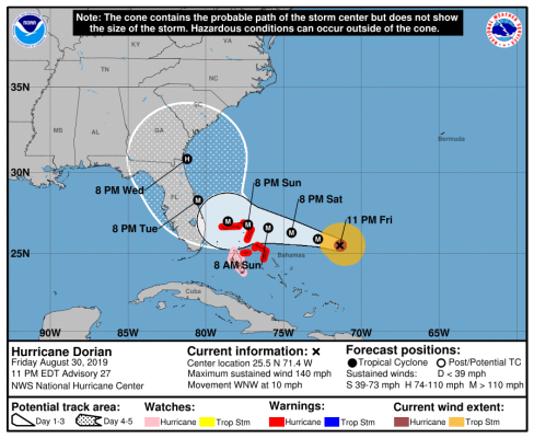
What the HE DOUBLE HOCKEY STICKS is it doing trying to come ashore at Jacksonville - we don't do hurricanes (very first and very last one last one was in 64 - Dora!)!

Go away you snot nosed little B!

I think that might have worked. Thank you.:blush:
 
"It is possible it never makes landfall but it would still impact land."


Florida is used to rain measured in feet , not inches.
 
Looks like its starting to follow the warm waters of the Gulf Stream!
 

Attachments

  • 090017_5day_cone_no_line_and_wind.png
    090017_5day_cone_no_line_and_wind.png
    77.2 KB · Views: 66
Good for us west coasters bad for the east siders. Hopefully the winds will diminish.
 
The forward speed is collapsing, it is moving very slowly and expected to not speed up. Talking about 24" rain over parts of Florida. and a very slow trudge up the Florida coast. Flash flood warnings going up all over the place. Delayed landfall possible now is late monday or tuesday 12 foot storm surges. Will be moving 4 or 5 mph.

Fla governor says expect to have no power for 7 days.

If your boat is taking in so much rain and storm water, can the bilge pumps run for 7 days with no shore power? Maybe you should add batteries.
 
Last edited:
The latest projection shows the hurricane stands a really good possibility of stay over the water, headed north, sparing FL from the winds but not, the rain. "Maybe" it will make landfall in SC
Interestingly, this marina could use the rain because the water tastes salty SMIRK
Let's see what the king tide and a storm surge will do.
 
Last edited:
Menzies

No, north to follow the Gulf Stream and go out to sea. I don’t want it and I wouldn’t wish it on you either. I’ve been through hurricanes in SoFla since the mid 40s and while I don’t fear them I don’t like them either.

Good luck all it does appear to be turning north.
 
Weather channel says potential future track has shifted a little eastward, and landfall could hit Northern Florida, Georgia or the Carolinas. Anyone who moved north, may have been a bad idea.
 
If anybody comes south to the keys to get away from Dorian we can help find them a temp tie up spot.

Bud
 
The cone of a forecast is there because they do not know what is going to happen - the rest is just for filling up hours of TV time.
A small change or "wobble" in the path would put just about everyone at risk based upon the current best guess forecasts.
It is way to early for anyone in the cone to feel comfortable.....based on past history of all storm tracking.
Good luck to all, be safe.
 
Back
Top Bottom