iPad app for navigation

The friendliest place on the web for anyone who enjoys boating.
If you have answers, please help by responding to the unanswered posts.

Fotoman

Guru
Joined
Nov 12, 2009
Messages
649
Any good navigation app for the iPad? I've been using Navionics for a few weeks now but I find it very limited compared to a real gps (very few functions apart from showing you where you are on the map and your speed). I was wondering if there was something better out there?
 
I have Navimatics. An app from Apple. $25. Marin turned me on to that. I bought it as a substitute for a great pile of charts. Always had that problem going up or down the coast. The number of charts for a 1000 mile trip on the PNW coast is staggering. The Navimatics lacks some detail but is very easy to use on the boat and a great way to make conversation about where you've been or where you're going. I use it mostly underway. I leave the plotter on where I need it like zoomed in close going around a point w some rocks out front while I keep track of the big picture w the I-pad on Navimatics. I can even leave it plugged into the DC 12V charger while I'm underway using it. Frequently I surf for possible anchorages ahead or alternative routes. For me it's the best $25 I've ever spent on Internet stuff. One needs to remember it's an app so you can use it without Wi-fi anywhere you are. I'm posting this on my I-pad but I need to have Wi-fi to do it. Once it's downloaded it's independent.
 
I second the Navionics, purchased the Polar view and downloaded charts but it is just too complicated:banghead: and customer support is a joke.
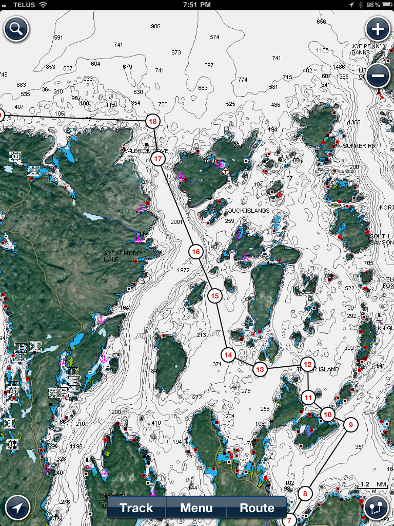
DT
 
Thanks guy. I've seen Navimatics on the iStore but it looks even more bare than Navionics (unless the screenshots and their website don't do justice to their product). I'm looking for something that would include all the usual features of a real gps. Maybe there is just no such thing for the iPad.
 
Mr Fotoman the $25 Navimatics I have shows too few names. Citys and towns are often called "built up area" and names of channels, inlets, bays and coves are missing but as Marin says to zoom in close often revals the names. The more important stuff like shallow water, rocks and shores are there in full detail. For the way I use it it's fine and I'd pay way more than $25 if I had to.
 
Is the Navionics the one that cost $49? I have a buddy that uses that one along with some type of satalite bluetooth puck that allows him to navigate without wifi or cell service.
 
Is the Navionics the one that cost $49? I have a buddy that uses that one along with some type of satalite bluetooth puck that allows him to navigate without wifi or cell service.

Yes it is and for the price you get all the charts for US and Canada. You can't beat that. One paper chart costs more than that. The level of details is great and the app gets updated very often. I just wish I could do more with it, like creating and saving routes.
 
I really like Navionics so I have it loaded on my iPad, iPhone and Lowrance HDS10 Gen2. Yes, one can save a route that is planned and a whole lot more and several routes can be saved. I presently have 8 saved on the iPad.

Here is a trip done sitting on the deck with a friend using the iPad.
img_92104_0_e1022e7b11d5b10bbae2832b24662984.png


I can figure out just how far an island, rock or buoy is away from my route.

img_92104_1_dd8a60b3742201a5d3b9b2a0296defcd.png


I can find out some info concerning what is close to me.
img_92104_2_b26de7ecda8622e1aabd02dedd669d0d.png


It can figure out my consumption etc.
img_92104_3_bbcea0edbde3af884f51a2326e1b08b3.png


It can tell the winds and tides.
img_92104_4_1dfb62ce67bc102beb0ed6675ca47db6.png


And some other interesting things about the day or tomorrow.
img_92104_5_6f9bd9d351f43145c3f0cb61c8f0e205.png


Elwin
 
Last edited:
Ok, that is pretty cool. Didn't know I could do that (or didn't figure it out). I'llplay with it more to figure out how to save different routes.
 
Thanks guy. I've seen Navimatics on the iStore but it looks even more bare than Navionics (unless the screenshots and their website don't do justice to their product). I'm looking for something that would include all the usual features of a real gps. Maybe there is just no such thing for the iPad.

Navimatics is NOT a navigation system. It's just an impressive collection of charts that can take the place of a big pile of paper charts or chartbooks. You can zoom in and out with a couple of finger swipes and as a planning tool, enroute or before departure, it is terrific. It interfaces with Active Captain so you can find anchorages or marinas and then get the info and reviews of them right on the chart screen from Active Captain.

Navimatics will lay a track behind your boat as you cruise along if you turn on the tracking feature. You do not have to be online to do this but you must have an iPad with internal GPS (only the 3/4G models have this built-in I believe, the wifi only models don't), and you can put a waypoint on the screen and navigate to it (in a straight line). But you CAN NOT create routes with multiple waypoints and all the other functions you have on a regular plotter.

As a planning tool, an enroute chart-checking tool, an Active Captain interface, and a "big picture" tool to zoom in and out quickly and scan the area around you (like with paper charts), Navimatics is outstanding in our opinion. As a navigational tool, it's not one.
 
Where did you find a manual? I love ours but have not figured out all the good stuff?

DT
 
dirtytom said:
Manual for the Navionics?

DT

I believe a CD came with mine, but check online there maybe a PDF you can download. I just played around with it and never looked at the DVD and can't seem to locate it now to be for sure.

Elwin
 
Take a look at iNavX. I tried Navionics first but really didn't like the fact that it only has a North Up orientation. iNavX is really a great app, and has a lot of functionality that I have not even tapped, such as integration with auto-pilot and more. It was a little clunky to buy, but has become my primary underway tool, leaving the older Raymarine chart plotter as the backup.

If you have a 3G enabled iPad, it has GPS built in and will work when out of GPS/wifi range. If you have a wifi only iPad, it does not have GPS and you will need a bluetooth gps "puck".
 
If you have a wifi only iPad, it does not have GPS and you will need a bluetooth gps "puck".
Bluetooth GPS for iPad used to require jail-breaking (not sure about the latest iOS) and were problematic.

I use a BadElf on mine and am quite satisfied with it.
 
I use the Navionics on my cell and iPad. I have open CPN on my laptop with a GPS puck. A word of caution on the iPAD, keep it out of the sun. They tend to dislike getting hot.
 
xuandong said:
Asian Star Anchor Chain which is the anchor chain factory is a specialized manufacturer of anchor chains and offshore mooring chains. All of the china anchor chain we offered are high-quality anchor chain.

Good to know if I ever wanted to to deep six my iPad! Crossing Asian Star off my shopping list ...
 
Our chief engineer (video, not aerodynamics :)) has just loaded a Jeppesen marine navigation app onto his iPhone and iPad called Jeppesen Marine Plan2Nav. The app itself is free but the charts you have to pay for. He said the chart (package?) he got for the Puget Sound area where he boats was $32. He said this got him chart coverage from the Columbia River to Nanaimo, BC or thereabouts.

In the app store the app has a review rating of two stars but there have apparently been updates. I have not loaded the app so have zero familiarity with it. But so far our engineer seems quite impressed with it. So I'm not recommending it, simply pointing out that it's there and perhaps worth checking out.

Or maybe someone here's already tried it and has a user's opinion he/she can share.
 
Back
Top Bottom