You are using an out of date browser. It may not display this or other websites correctly.
You should upgrade or use an alternative browser.
You should upgrade or use an alternative browser.
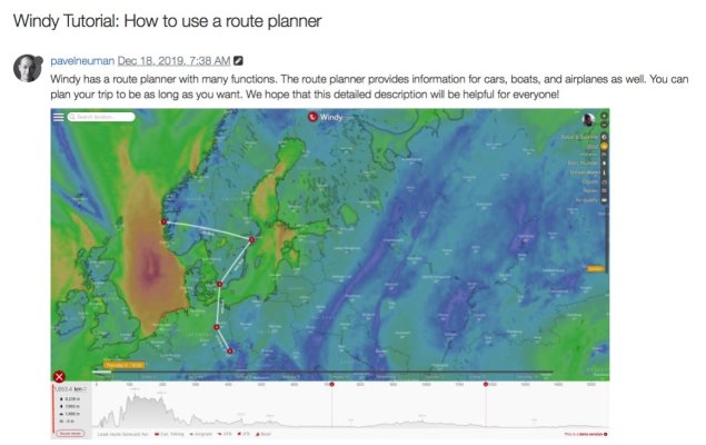
Route Planing on Windy
- Thread starter Codger2
- Start date
The friendliest place on the web for anyone who enjoys boating.
If you have answers, please help by responding to the unanswered posts.
If you have answers, please help by responding to the unanswered posts.
You may have to register to access this feature, assuming it really exists.
Even if it did exist, I don't think I would use it.
I use Windy as a go no go decision tool when I plan an immediate trip (within the next day or two). So for example, in another month I am going to make an offshore trip from northern Florida to Charleston, SC. I will scroll the time forecast forward a day or two to when I will be on the water and then see if the conditions will be ok. I don't need a route superimposed on Windy's map to do that.
FWIW I will also look at 24 hours before and after the trip in case a front comes through sooner or later than forecast. If a big wind shift is forecast even 12 hours after I plan to be on the water I won't go. I will often check windy along the way to make sure the forecast is holding.
FWIW this posting took longer to type than I usually spend on Windy with no routes.
David
I was not aware of this feature but have been a Windy fan.
When exploring I find 2 different paths to access.
On the App
If you go to menu (3 bars) - settings - menu (@top) - distance & planning is one of the choices
On the website
It more direct - Menu (bars at top L) - Distance & Planning
Not sure how I would use it for forecasts but would be interested in experiences.
OP
OP
Codger2
Guru
- Joined
- Oct 11, 2007
- Messages
- 6,691
- Location
- US
- Vessel Name
- Circuit Breaker
- Vessel Make
- 2021..22' Duffy Cuddy cabin
Thanks much, Don! The video I saw showed the guy following along the route with his cursor and the forecast for that exact cursor location appeared above the cursor. If he continued moving his cursor, the forecast kept pace with forecast changes.Not sure how I would use it for forecasts but would be interested in experiences.
I am hooked! Just wish I could use it on my MFD as the only weather program that the MFD runs id Theyr.

OP
OP
Codger2
Guru
- Joined
- Oct 11, 2007
- Messages
- 6,691
- Location
- US
- Vessel Name
- Circuit Breaker
- Vessel Make
- 2021..22' Duffy Cuddy cabin
I've done both of the above but cannot plot a course in either one!.On the App
If you go to menu (3 bars) - settings - menu (@top) - distance & planning is one of the choices
On the website
It more direct - Menu (bars at top L) - Distance & Planning

OP
OP
Codger2
Guru
- Joined
- Oct 11, 2007
- Messages
- 6,691
- Location
- US
- Vessel Name
- Circuit Breaker
- Vessel Make
- 2021..22' Duffy Cuddy cabin
I have registered but no cigar for my efforts. I do exactly as you described but after seeing the video I mentioned above, it is even easier to see the forecast along a route! And as you say, moving the time line forward & backward will display any changes or alerts. (If you have that turned on.)You may have to register to access this feature, assuming it really exists.
Even if it did exist, I don't think I would use it.
I use Windy as a go no go decision tool when I plan an immediate trip (within the next day or two). So for example, in another month I am going to make an offshore trip from northern Florida to Charleston, SC. I will scroll the time forecast forward a day or two to when I will be on the water and then see if the conditions will be ok. I don't need a route superimposed on Windy's map to do that.
FWIW I will also look at 24 hours before and after the trip in case a front comes through sooner or later than forecast. If a big wind shift is forecast even 12 hours after I plan to be on the water I won't go. I will often check windy along the way to make sure the forecast is holding.
FWIW this posting took longer to type than I usually spend on Windy with no routes.
David
murofrelwart
Senior Member
I wasn't aware of this feature but I just tried it and it works great for me on the PC, using Chrome and Windows. However, I'm not finding it on my Android tablet.
Ok,using the web version, I used the distance and planning feature to add waypoints. Then when you click on "boat" at the bottom, the weather at each hour of the route shows up. But how do you set the boat speed? It looks like the default is to spread the trip over 7 days.
Even if I can find out how to set boat speed, I don't find the route tool all that helpful. And how do you set the start time and date?
David
Even if I can find out how to set boat speed, I don't find the route tool all that helpful. And how do you set the start time and date?
David
OP
OP
Codger2
Guru
- Joined
- Oct 11, 2007
- Messages
- 6,691
- Location
- US
- Vessel Name
- Circuit Breaker
- Vessel Make
- 2021..22' Duffy Cuddy cabin
Interesting! I can't find it on my iMac or iPhone either!I wasn't aware of this feature but I just tried it and it works great for me on the PC, using Chrome and Windows. However, I'm not finding it on my Android tablet.
OP
OP
Codger2
Guru
- Joined
- Oct 11, 2007
- Messages
- 6,691
- Location
- US
- Vessel Name
- Circuit Breaker
- Vessel Make
- 2021..22' Duffy Cuddy cabin
Good question...What tics me off is that there's no "go to" link for getting questions answered.Even if I can find out how to set boat speed, I don't find the route tool all that helpful. And how do you set the start time and date?

murofrelwart
Senior Member
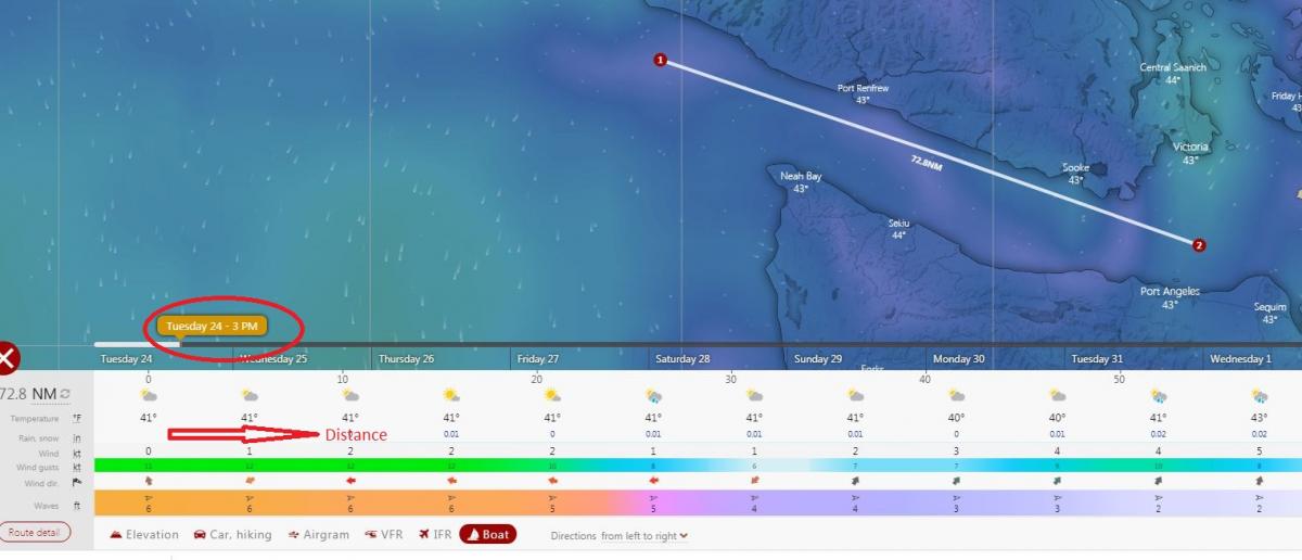
The horizontal weather data at the bottom is the forecast along your route at the specific time shown in the timeline just above the weather data. I circled this in red. The timeline does not correspond to the distance.
If you move your cursor over either the route or the weather data it display distance from the start point. If you slide or click different times in the timeline then you can see how the forecast changes along your route at that specific time.
It's kind of confusing and hard to explain, but hopefully you can follow.
I don't see a way to show varying weather forecast along the route for a particular speed.
murofrelwart
Senior Member
Good question...What tics me off is that there's no "go to" link for getting questions answered.
I found a feedback/FAQ section on the website. Here is a link to FAQs tagged as "Route Planning"
https://community.windy.com/tags/route%20planning
OP
OP
Codger2
Guru
- Joined
- Oct 11, 2007
- Messages
- 6,691
- Location
- US
- Vessel Name
- Circuit Breaker
- Vessel Make
- 2021..22' Duffy Cuddy cabin
GEEZ! I'm envious! I'm not even able to plot waypoints!If you move your cursor over either the route or the weather data it display distance from the start point. If you slide or click different times in the timeline then you can see how the forecast changes along your route at that specific time.
It's kind of confusing and hard to explain, but hopefully you can follow.
I don't see a way to show varying weather forecast along the route for a particular speed.

After selecting the distance and planning do you get a cross as a cursor? I did and simply click for a start location and then keep clicking for waypoints.GEEZ! I'm envious! I'm not even able to plot waypoints!
I did get the fcast at the bottom but wouldnt expect much difference with short distances.
I find it easier to enter and save a few locations I plan on cruising to and look at the fcst for the next / each of the selected points
OP
OP
Codger2
Guru
- Joined
- Oct 11, 2007
- Messages
- 6,691
- Location
- US
- Vessel Name
- Circuit Breaker
- Vessel Make
- 2021..22' Duffy Cuddy cabin
Thanks, Don. I finally got it to work on my boat's smart TV but iPhone, not so much! Also, I wrote a rather detailed reply on what I found. (my iMac is too old and won't support the route planning function) Your suggestion on saving a few locations for later is a good one and will be included in my planning.After selecting the distance and planning do you get a cross as a cursor? I did and simply click for a start location and then keep clicking for waypoints.
I did get the fcast at the bottom but wouldnt expect much difference with short distances.
I find it easier to enter and save a few locations I plan on cruising to and look at the fcst for the next / each of the selected points

fgarriso
Guru
Everyone is free to do as they please.
But I wouldn't trust it to do route planning to feed to a autopilot.
I think I would display the plotter on one screen and Windy on a different for reference.
But I wouldn't trust it to do route planning to feed to a autopilot.
I think I would display the plotter on one screen and Windy on a different for reference.
Agree.. it may be useful for looking ahead for Wx fcst. I dont see it for APilot use.
Everyone is free to do as they please.
But I wouldn't trust it to do route planning to feed to a autopilot.
I think I would display the plotter on one screen and Windy on a different for reference.
4fun1
Senior Member
This is from the "how to use" section of the app menu on my android phone.
Routes
You can see the length of your route and check the forecast for any spot you've marked.
1. Open the map
2. Mark any spot and press "Add to route".
3. Add to route as many spots as you like.
[https://static]
Routes
You can see the length of your route and check the forecast for any spot you've marked.
1. Open the map
2. Mark any spot and press "Add to route".
3. Add to route as many spots as you like.
[https://static]
OP
OP
Codger2
Guru
- Joined
- Oct 11, 2007
- Messages
- 6,691
- Location
- US
- Vessel Name
- Circuit Breaker
- Vessel Make
- 2021..22' Duffy Cuddy cabin
I agree! I also see it as a great planning tool with information that is data based, not human generated. I studied damn near all the available weather programs and I think Windy is one of the very best, if not the best!Agree.. it may be useful for looking ahead for Wx fcst. I dont see it for APilot use.

I studied damn near all the available weather programs and I think Windy is one of the very best, if not the best!
I looked a several before an extended US / Canada Cruise in 2019 and came to the same conclusion. Here is a short article I wrote for our ABC-FLX boating club as an intro to Windy. Hope it helps.
Attachments
OP
OP
Codger2
Guru
- Joined
- Oct 11, 2007
- Messages
- 6,691
- Location
- US
- Vessel Name
- Circuit Breaker
- Vessel Make
- 2021..22' Duffy Cuddy cabin
Thanks for including your article, Don. I read it and saved it to my library. It's a very informative article.I looked a several before an extended US / Canada Cruise in 2019 and came to the same conclusion. Here is a short article I wrote for our ABC-FLX boating club as an intro to Windy. Hope it helps.
I'm 79 years old and have messed around in boats since I was 10 and the weather thing has always interested me. In 1967 I earned my commercial pilots license and was stunned at how little instruction time was devoted to weather information. Discovering Windy.com is one of my most interesting finds for my cruising needs. There's a lot to learn from it and I process more info from it every day.
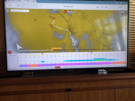
Here's just one example of a tool that shows what you can see with one click on your route. This route is on a strait line from San Diego to Catalina Island. There's no course line as my old iMac couldn't plot it.(My smart TV does, however!) It not only shows swell height & time interval, it also shows wind speed & from what direction for both swell and wind.
Attachments

Last edited:
Codger2
If interested in digging more into Wx the USPS aka Americas Boating Club Wx course is worthwhile. NOAA also has a comprehensive Wx course online with session questions to check comprehension.
If interested and you can't find it send me a PM and I can provide a link.
What you showed for windy along a route is what I have done previously by saving some favorite locations and then clicking on them. I'll be playing with courses to see if it is easier.
Thnx
OP
OP
Codger2
Guru
- Joined
- Oct 11, 2007
- Messages
- 6,691
- Location
- US
- Vessel Name
- Circuit Breaker
- Vessel Make
- 2021..22' Duffy Cuddy cabin
Codger2, NOAA also has a comprehensive Wx course online with session questions to check comprehension. Yes!......What you showed for windy along a route is what I have done previously by saving some favorite locations and then clicking on them.
I'll be playing with courses to see if it is easier. Please keep me posted on this!
Thanks so much for your input, Don....It's great to have a new opinion on Windy!
Last edited:
Wxx3
Dauntless Award
- Joined
- Jan 10, 2013
- Messages
- 2,820
- Location
- USA
- Vessel Name
- Dauntless
- Vessel Make
- Kadey Krogen 42 - 148
Wonderful idea.Thanks for including your article, Don. I read it and saved it to my library. It's a very informative article.
I'm 79 years old and have messed around in boats since I was 10 and the weather thing has always interested me. In 1967 I earned my commercial pilots license and was stunned at how little instruction time was devoted to weather information. Discovering Windy.com is one of my most interesting finds for my cruising needs. There's a lot to learn from it and I process more info from it every day.
Here's just one example of a tool that shows what you can see with one click on your route. This route is on a strait line from San Diego to Catalina Island. There's no course line as my old iMac couldn't plot it.(My smart TV does, however!) It not only shows swell height & time interval, it also shows wind speed & from what direction for both swell and wind.
Now, get out there and verify how accurate it is.
I use Windy for no- no go decisions and possible wx windows.
To use it and expect accuracy in route planning is cruising for a bruising.
Along the west coast, from Panama to Alaska, I found its point forecasting to be useful, as long as I used a range of 50% and 12 hours.
Roughly, this means that with winds forecast to be 270° at 12 kts at 12z. I plan for a range of winds from 230° to 310° from 6 kts to 18 kts at 12z.
Generally I've found that on the ocean , as opposed to inland waters, the wind speed is under forecast 90% of the time.
But there could be some use bias in that observation, in that I'm not going out if winds are fcst to be 20 kts, but in reality only 15. But i notice when fcst to be 5 and they are 12.
Use Windy, which I also think is the best GUI out there, as a general wx conditions tool, not as a spot fcst for any given time and place, as it won't be accurate.
Richard on Dauntless and ex wx man
Richard
Just wanted to say thanks for introducing me to Windy and for your advice. I have to say our great lakes experience last year was very successful Wx wise and made for pleasant boating. In one case we waited for a favorable window and in another we cut a stay short to take advantage of a better window. All due to Windy
Thanks
OP
OP
Codger2
Guru
- Joined
- Oct 11, 2007
- Messages
- 6,691
- Location
- US
- Vessel Name
- Circuit Breaker
- Vessel Make
- 2021..22' Duffy Cuddy cabin
I have been doing exactly that with a few of my favorite routes and have been able to retrieve them when logging back on to the Internet. I can look a route up days later & by moving the time line on the bottom of the screen, I get a brand new forecast! As previously noted, this exercise is specifically for easy route planning and not for the auto pilot. As previously stated, I use my iPhone hot spot and my salon'e smart TV for the planning functions.I find it easier to enter and save a few locations I plan on cruising to and look at the fcst for the next / each of the selected points
Attachments
racerrick
Member
Using Windy.com
All the comments about using Windy & its various weather features are accurate & useful. It is not, however, a chart plotter. It is useful to estimate cruise distance from estimated waypoint to waypoint & from that TSD & fuel calculations can be reasonably estimated, particularly in inland & near coastal waters. That feature has been accurately described in previous posts. It is a tool to estimate routes/TSD/fuel, not to chart plot. It is indeed a great weather instrument, particularly with go-no go decisions & predicting wind/wave conditions over longer cruise times. Even having Sirius weather on my Garmin for current & radar information, my first go to is Windy. As a first choice or as a backup chart plotter on a laptop, Coastal Explorer is very good & features automatic, frequent chart updates. I use my Garmin split screen chart plotter/radar (I personally am not a fan of radar overlay of the navigation chart but that is personal choice) & Coastal Explorer on a Getac laptop as a larger display underway. The update feature of Coastal Explorer also reduces the frequency of buying current 2gVision chips.
All the comments about using Windy & its various weather features are accurate & useful. It is not, however, a chart plotter. It is useful to estimate cruise distance from estimated waypoint to waypoint & from that TSD & fuel calculations can be reasonably estimated, particularly in inland & near coastal waters. That feature has been accurately described in previous posts. It is a tool to estimate routes/TSD/fuel, not to chart plot. It is indeed a great weather instrument, particularly with go-no go decisions & predicting wind/wave conditions over longer cruise times. Even having Sirius weather on my Garmin for current & radar information, my first go to is Windy. As a first choice or as a backup chart plotter on a laptop, Coastal Explorer is very good & features automatic, frequent chart updates. I use my Garmin split screen chart plotter/radar (I personally am not a fan of radar overlay of the navigation chart but that is personal choice) & Coastal Explorer on a Getac laptop as a larger display underway. The update feature of Coastal Explorer also reduces the frequency of buying current 2gVision chips.
- Joined
- Feb 14, 2018
- Messages
- 713
- Location
- United States
- Vessel Name
- Wanderlust
- Vessel Make
- 1999 Jefferson Rivanna 52'
We used Windy and it's route planning feature along with NOAA forecasts over a period of several days to form a go/no-go decision for a Gulf crossing earlier this week. We found Windy's predictions to be spot-on, even down to the hour things would start to get sloppy as we arrived at the coast. It helped make for a successful crossing. I'm a believer.
tpbrady
Guru
Richard,
I went back and reread this thread while I am sitting in the rain and wind in Wrangell, and thought I would get your opinion on Windy in regard to inland waters in SE Alaska. I have found Windy to more or less useless for inside waters of SE. Winds rarely if ever blow across straits like Clarence or Chatham. They are generally funneled by terrain. Windy does not take into account terrain whereas NOAA does. For example Windy shows winds at Lincoln Rock (LCNA02) as SW at 8 knots. The current observation from NOAA is SSE at 20 with gusts to 30 knots. Windy in this case is not even close. The best example of terrain funneled winds is often found in Sumner St. With any wind with a southerly component, the portion of Sumner St south of Pt Baker will be subject to the wind, while the area from Pt Baker east to Red Bay will be ok, then the wind blowing up through Snow Pass takes over. The stronger winds in Clarence St with a southerly component sometimes make the portion of Sumner St east from Pt Baker to Snow Pass pretty rough. From Port St John east to Wrangell, winds are generally not a factor most of the time. Windy is too macro in its view to show this, making it generally not a very good tool for inside waters.
Tom
- Joined
- Oct 6, 2007
- Messages
- 841
- Location
- Poulsbo, WA
- Vessel Name
- Dream Catcher
- Vessel Make
- Nordic Tug 37-065
Hi Tom,
Can't comment much on Windy's accuracy in SEAK's narrower channels (especially odd spots like Lincoln Rock), but for me and friends it has been excellent for the outside, and for crossing the Dixon.
Its very granular forecast is so much more useful than NOAA's area forecasts - enabling us to make correct go-nogo decisions in weather that sounded very iffy on NOAA. I find it very good in BC as well.
Predictwind is similarly good in my experience.
Similar threads
- Replies
- 3
- Views
- 621
- Replies
- 11
- Views
- 2K