Little Harbour cut to Egg Island?

The friendliest place on the web for anyone who enjoys boating.
If you have answers, please help by responding to the unanswered posts.

cardude01

Guru
Joined
Nov 26, 2012
Messages
5,290
Location
USA
Vessel Name
Bijou
Vessel Make
2008 Island Packet PY/SP
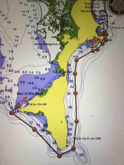
I think we are going back to the Abacos again this June instead of the Exumas since this is my wife’s first extended time on the boat and I want to limit lots of longer open water crossings. Cross from Lake Worth to West End, which I think I can do in one long day.

However, if things go well and she’s comfortable, after the Abacos instead of reversing course and going back to West End, I’m wondering about the feasibility of taking the Little Harbour cut to Egg Island (about 55 miles) if I can find a good calm day, then exploring Eleuthera. Then to Nassau, then Chubb, then Bimini. Maybe. [emoji6]

Is that Little Harbour cut pretty easy in good weather? The chart says the Egg Island Cut is pretty easy?

It seems lots of people go from Abaco to Spanish Wells, but the chart I’m looking at says you need a guide to get through that Ridley Head channel to Spanish Wells, but maybe I’m looking at it wrong.

After Egg Island, would have to take that Current Cut I suppose to get to the Eleuthera Sound, unless I go farther south to the Fleming Sound. How is that Current cut? OK as long as I catch it at slack tide?

Thanks!
 
We explored the Abacos and that included Little Harbour. Stayed there a day and left out the inlet, passed Hole in the Wall and made it to the Berry's. Little Harbor channel in and out was super easy, but out was in calm conditions so that helped.

We did not go to Eluthera, so can't help with that.

Our basic path was this: Ft. Pierce, anchor at Great Sale, clear in Abacos (Green Turtle, I think), mucked around Sea of Abaco, stopping in Great Guana, Elbow, Marsh Harbour, then Little Harbour. Back out to sea to Berries (Great Harbour), then to Bimini, then to Cudjoe Key 20nm up from KW. Of course both ends of the trip involved running from NC to S.fla and back...

Never had any problems with depth in the Bahamas. About a 3' draw. Cudjoe was sketch, but made it ok, and that's not your topic!
 
I was just looking at your last trip. Glad you commented.

When you went from Little Harbour to Great Harbour did you do that all in one day? I don’t think I can make that in a day, but think I could make it to here to anchor? Then go across the open water to Great Harbour the next day.
IMG_7484.JPG
IMG_7484.JPG


Doesn’t look like many places to anchor along the bank of Great Abaco to get out of the weather/east winds.

Where is Hole in the Wall?
 
Last edited:
Leaving Cape Eleuthera to run to Rock Sound on Friday, then through Current on Sunday to Spanish Wells. On Monday or Tuesday we will run north east out of Spanish Wells to enter Abaco at Little Harbour. Plan to either pick up a ball or anchor off Pete's Pub.
So I am doing your route, only backwards. Stay tuned for an update next week after I do it.
Going to and leaving Spanish Wells staying west of the Devil's Backbone (Gun Point - Ridley Head route) I believe it is pretty straight forward and well marked and charted. It is if you want to run Devil's Backbone down to Harbour Island that a pilot is recommended.
 
Last edited:
And Hole In The Wall is the southeasternmost tip of Great Abaco. It got that name because of a rock formation that was there until about eight years ago when it collapsed during a storm.
 
Hole in the Wall is on S tip of Abaco, right under the lighthouse.

There looks to be some harbors on SE face of Abaco below Little Harbour, but never explored them. Depends on how rough it is from the SE.

We did make Great Harbour from Little Harbour in a day. Looked at the log and it was 83nm. We ran a fair part of the jump at 18-20kts, so that helped.
 
Last edited:
Leaving Cape Eleuthera to run to Rock Sound on Friday, then through Current on Sunday to Spanish Wells. On Monday or Tuesday we will run north east out of Spanish Wells to enter Abaco at Little Harbour. Plan to either pick up a ball or anchor off Pete's Pub.
So I am doing your route, only backwards. Stay tuned for an update next week after I do it.
Going to and leaving Spanish Wells staying west of the Devil's Backbone (Gun Point - Ridley Head route) I believe it is pretty straight forward and well marked and charted. It is if you want to run Devil's Backbone down to Harbour Island that a pilot is recommended.


Excellent. I will await the blog.

Do you ever use route planning like I did in my above Garmin chart? (The thick brown line). It sure would be useful to see your actual routes.
 
Hole in the Wall is on S tip of Abaco, right under the lighthouse.

There looks to be some harbors on SE face of Abaco below Little Harbour, but never explored them. Depends on how rough it is from the SE.

We did make Great Harbour from Little Harbour in a day. Looked at the log and it was 83nm. We ran a fair part of the jump at 18-20kts, so that helped.


Ok cool. Thanks. Yeah I def cannot make 83 miles in one day.

I’d rather shoot over to Eleuthera from Little Harbour and check that area out, but if not I may end up in the Berrys.
 
Excellent. I will await the blog.

Do you ever use route planning like I did in my above Garmin chart? (The thick brown line). It sure would be useful to see your actual routes.

I don't, but I have thought about adding one to each blog entry where I am and have been. But this time will probably just do one map at the end of the trip.
 
Cool. Any routes shown on charts would be very helpful for us wannabes.
 
We ran from Great Harbor Cay to Schooner Bay, spent the night, then on to Little Harbor. 15 knots or so from s-se, was choppy on the fwd quarter from GHC to Hole In the Wall, then pretty big following swells from there to schooner bay. The entrance is hard to see from the water going into Schooner Bay, you kind of have to go in on faith and a swell makes it a bit hairy, but once you are in it's nice.


Was an easy run from there to Little Harbor then next day, though still a big swell.
 
Doug,

Thanks. When you say “go in on faith” I assume there are no markers as usual in the Bahamas. Was it hard to read the water going in because of a lack of sunlight? Too rough?

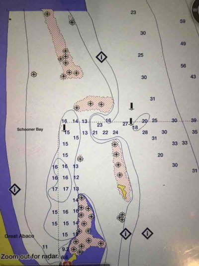
I don’t have my paper Explorer charts in front of me but see this dotted line going into Schooner Bay. Does that look like the route you used?

IMG_7484.JPG
 
Dude,

I was there 2 years ago and both Little Harbor and the Spanish Wells inlets were a non-event, very straight forward. We enjoyed Spanish Wells( only 2 nights there) , hope to explore more of Eleuthera some day.

When in June are you leaving? If you are still on the west coast and passing thru Ft Myers, give me a shout. We keep our boat in the area and will be there around that time cruising to the Keys and back.

Rafe
 
Rafe,

Good to hear from you! Thanks for the info. I always tend to read those active captain comments on inlets and tend to freak out, then get there and find out it was nothing (in good weather).

We are still on the west coast on Longboat Key. Plan on going first of June lord willin’ and creek don’t rise. Will probably go the lake route to get to the east coast so will holler when going through your way.
 
Hey Car Dude,


It's been three years since we last went into Schooner Bay, so it could have changed or I may remember it wrong, but I only recall a single buoy marking the entrance. I think it was the green between the 15 foot and 16 foot depth markings on your chart. You leave it to port and run right along the beach, about 200' off. Once you get close the actual harbor entrance is easy to see, there is a breakwater there. Picking up the buoy is the hard part. It was tough to see in the swell when went in.


The other two markers may have been there as well, I just don't recall them.


We also used the rock shown on the chart as a marker, the yellow spot just south of the four coral heads. It was pretty easy to see.


I'm making it sound harder than it was, I think you won't have any problems, especially if there isn't a big swell. Schooner bay is a nice stop to cut that trip by a third. They have fuel right at your slip and are very nice. There was an organic vegetable market there when we went, but I have heard that it is closed now.


Good luck!
 
Back
Top Bottom