Radar "Required" or "Optional" for Great Loop?

The friendliest place on the web for anyone who enjoys boating.
If you have answers, please help by responding to the unanswered posts.
In 40 years of boating on inland river waterways (upper mississippi and upstate NY), I never felt the need to have radar.


However, during a recent 1,200 mile run on the eastern ICW over a span of five weeks, there were at least three times we were >>extremely<< glad we had the radar, and avoided one near collision. In addition, there were a number of days when we'd have been stuck in port, unable to leave in time to make our next destination due to morning fog in the forecast.


Bottom line, I can't imagine doing any extended near-coastal cruising without radar.


If price is the obstacle, you can pick up an older used unit on Ebay for under $1,000.

River guy,

Glad your radar paid off. As for not needed it with 40 year, that's amazing. Suspect you did occasionally run into some fog?
 
You'd be surprised how proficient I am at tweaking radar. And my extensive use of modern marine electronics. They are not a substitute for looking out the window, nor insurance against collision. They are merely another tool - seamanship and collision avoidance isn't a video game.

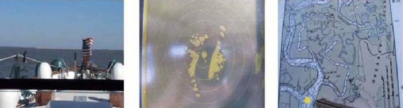
There are small fishing boats (and yachts) that do not produce a reliable return on a small dome radar, even at fairly close range, even in flat calm conditions. In nasty conditions with rain and sea clutter, even fairly large targets are not identifiable as such. This isn't just me, it is also the conclusion of several CG and MAIB investigations into fatal collisions at sea. See for example the MAIB report on the sinking of the Ouzo, run down by a ro-ro passenger ferry in a moderate sea state. Conclusion was the yacht was invisible on both high power X and S band, operating properly with a vigilant trained and licensed crew. This is one of several such investigations. As a result of these sorts of investigations, on the sailboat I carry an active radar transponder that produces a return on both X and S band similar to a 30,000 ton ship.

I've navigated the length of Down East Maine in heavy fog, about 1/3 of the lobster boats encountered left no radar return ever, or not until very close (when you could hear and see them). Yes I adjusted the knobs. I've similarly done that in anchorages and on passages in broad daylight to see what paints and what does not.

Some lobster boats in Maine were rude in their passing, but at least someone was driving them while they were moving. Twice on the Nova Scotia coast I had to alter course to keep from being run down by 150' steel trawlers. They did not respond to hails, and binoculars confirmed an empty bridge. These were not sport fishermen, and their radar was of little use to them.

DDW,

There's something just wrong. The cheapest dirtbag crappy radars will paint small fishing boat and especially yachts. May not give a ton of range, but they will show up enough to avoid a collision, unless it's just broke. I've thrown 3 or 4 of them away that would work that well. (The old RayMarine stuff).

Heck, my new entry level cheap dome radar will paint a crab bouy, let alone small boats, kayaks and such... now gotta have reasonably smooth water. And the entry level dome radars won't give the range that they advertise. But they offer a lot for the money.
 
.................
If price is the obstacle, you can pick up an older used unit on Ebay for under $1,000.

River guy,

That's not the best advise when you can get a new one for about $1500. The best of the dome ones are only $2000, no need to buy old technology and one that might have a failing magnetron. I wouldn't install a used radar if it were free.
 
Fish,

No doubt you've had a fair amount of experience and certainly a lot of good training. I'll always take a suggestion for additional training.

Have never taken a marine radar specific course but sure would mind getting a recommendation. The one you go to up in the new England area is just to far away, however.

Also, I've been to a few aviation radar courses with the best... Archie Trammel and Dave Gwinn that absolute best in aviation radar. And even though the radars are for entirely different missions, the concept is much the same.

As for letting a chart plotter do the navigation, I'm guilty. That's what the heck I bought it for! I'll often do an auto route and couple it to the autopilot. It's actually safer using it than not. Frees me to just monitor it and pay attention to other things. On my recent Loop trip, I've found it extremely accurate. I'd bet you guys do similar in the commercial operations, too.

I know there's a school in Ft. Lauderdale, I think its Maritime professional training or something like that. I would assume Florida would have a number of schools offering radar courses. I understand the allure of chart plotters, and they are great but like many things they're great until they're not. I use them all the time but I also still take bearings even if it's just a bow and beam bearing. Also when I'm offshore I still take my sextant and I always have paper charts wherever I go.
 
River guy,

That's not the best advise when you can get a new one for about $1500. The best of the dome ones are only $2000, no need to buy old technology and one that might have a failing magnetron. I wouldn't install a used radar if it were free.

I can buy a new Furuno 1815 locally for about $2000 and it's a very good little radar.
 
HiDHo,

You're right, your radar was painting over the ground and picked up the top of the tow. Mine would do the same occasionally, but found the ground clutter too confusing to be useful. Once the guy came around the corner, they could easily be seen, radar or eyeballs. The radar just does NOT curve around corners.

AIS can see around corners, and you can overlay it on most newer plotters and radar.
 
Also true of AIS and bends, technically line of sight because its VHF....but I know its gonna punch through or miss most obstacles but solid ground, buidings, and any other dense objects on river bends

If there is enough sea cutter, it IS hard to tune small radars to pick up every small craft.

That includes many small boat radars, even the 20kW radar in USCG helos had trouble in some sea conditions at certain ranges.

Part of operating anything is to know it's limitations.
 
Someone was asking about radar training. MPT offers Radar Observer Unlimited as a 5 day course for $799.

Also, recertification is required every five years for radar endorsement and is 1 day for $199.

Also, a three day Radar Refresher course for $399.

Also, courses in ARPA, Automatic Radar Plotting Aids, and it's use for collision avoidance and navigation.

We've had the five day course and it was incredible, especially the part using the simulator.
 
Fish,

No doubt you've had a fair amount of experience and certainly a lot of good training. I'll always take a suggestion for additional training.

Have never taken a marine radar specific course but sure would mind getting a recommendation. The one you go to up in the new England area is just to far away, however.

Also, I've been to a few aviation radar courses with the best... Archie Trammel and Dave Gwinn that absolute best in aviation radar. And even though the radars are for entirely different missions, the concept is much the same.

As for letting a chart plotter do the navigation, I'm guilty. That's what the heck I bought it for! I'll often do an auto route and couple it to the autopilot. It's actually safer using it than not. Frees me to just monitor it and pay attention to other things. On my recent Loop trip, I've found it extremely accurate. I'd bet you guys do similar in the commercial operations, too.

Great points Fish and Seevee.

Training is so important if you can get it! IMO, it's best to be able to train on your own gear since there are so many variables among floating radar units. My radar is an old Raytheon (pre-Raymarine) SL70 standalone that works great. I'd love an overlaying digital unit with AIS but other priorities dictate delayed gratification of that itch.

I also came from an aviation background and attended Archie Trammel's radar course in my 30s...about 30 years ago. It was a great resource for radar specifics even to a group of former Air Traffic Controllers and Flight Inspectors of radar installations around the world like us. As a Flight Inspection Pilot, we'd calibrate, adjust, and certify military and FAA radar installations of all types...ASR, PAR, ARSR as well as shipboard search and fire control systems. There are lots of radars out there but they ALL operate the same way. But all that is useless if you can't adjust your unit as designed.

I also have never attended classroom training for marine radar but have used my career knowledge to supplement that deficiency. I bet someone running an On-The-Road marine radar course for amateur mariners could make hand over fist while providing a real benefit to the participants.
 
If you knew as many Maine lobstermen as I do you'd realize that most of them are rude primarily because they're on the water every day and every day recreational boaters do something stupid. I ran ferries in Maine on and off for years and the best way to deal with lobsterboats is ignore them, most of them are very good seaman with years more experience than most rec. boaters ever get. I can't effectively address your difficulties with radar but from what you said it sounds to me like you could benefit from some training. As to the supposed Canadian trawlers with no one running them I doubt this very much, having operated large trawlers for many years only a fool leaves the wheelhouse unattended. I would guess that they may have had heir gear in the water and as such had the right of way. Some midwater trawlers tow at speeds far faster than bottom trawlers and may appear to not be fishing. As I stated elsewhere I take my seamanship skills very seriously and can say with some pride that in forty five years of running all kinds of boats from an outboard skiff to a 25o' factory trawler I've never been in a collision, run aground or most important I've never lost a crewmember. Trust me, I want you to be the best boat operator you can be as I'm out there too.

I give lobstermen some slack because of what they do, but I've seen complete idiocy from some of them too. They're just people after all.

You weren't there when the Canadian trawlers went by. Full speed, no gear in the water, did not have the right of way over a sailboat sailing. I don't know what they were doing, playing cards?

Some of you'all are acting like I've said radar is useless. Did not say that. Just said it isn't a magic wand. I've navigated for decades in fog without it, never hit anything either. A decade or so with it, still haven't hit anything. I already said upthread they are so cheap you might as well have one. And by all means practice or take a course. Better with it than without. But if you think it is showing the whole and complete picture, particularly in weather, you are sadly mistaken. As countless radar assisted collisions have proven.
 
Al, Club Nautique in Alameda offers radar seminars on occasion and they are excellent. Also included in their advanced cruising classes, which when i took it included getting out of a harbor (in our case the interior of Pigeon Point) at night using only radar.
 
A metal boat is most likely to return a strong radar reading.
 
Al, Club Nautique in Alameda offers radar seminars on occasion and they are excellent. Also included in their advanced cruising classes, which when i took it included getting out of a harbor (in our case the interior of Pigeon Point) at night using only radar.

Great to know, George! I'll look into it. Thanks!
 
Not always Mark Pierce.
 

Attachments

  • FD802668-0438-485F-B6B2-2799CF1D6F4F.jpeg
    FD802668-0438-485F-B6B2-2799CF1D6F4F.jpeg
    111.1 KB · Views: 25
You're welcome Al, by the way I obviously meant Pillar Point, not Pigeon Point!

Let us know what they offer these days at CN, they can be a great resource though I recall if you're not a member the prices are higher. We belonged because we rented boats from them a lot when we lived out there last. They required the classes for various levels of boat and cruising grounds, and it was perhaps the best money I ever spent on boating as it turned us from sporadic day boaters into cruisers. Though we had boated for our whole life, and owned a 32' Tolly when we lived in Seattle, and had taken USCG Aux classes, was amazed at how much I didn't know what I didn't know. At the time they had a complete fleet of Mainships of all sizes and configurations. I believe the power boat fleet is greatly reduced these days. They are primarily a sailboat operation. We even kept the membership for awhile after we moved to Texas. For people looking into buying a boat in SFO who are still working, it is a great alternative.
 
Great discussion guys!

Best posts so far, #35 and #38.

I have had radar on my boats since 1988. I would never go back to being without it. I also agree with Mark that your eyes are your best resource. My Radar clocks the amount of time it has been turned on. On my boat, it shows me how many hours I have navigated from my lower helm since installing that set. I don't often leave it turned on while I am operating from the upper helm, as I can't see its display while up top.

In training on the RCMSAR rescue boat, I have learned a lot more about the usefulness of Radar, and I would recommend anyone, even those with many years of Radar experience, to take some CG training to upgrade your skills with Radar (and other things too).

If you don't turn it on when visibility is good, you can't see everything it is telling you when visibility is poor.
 
Last Spring I was moving the boat to a new port on Lake Michigan. I was single handing the boat. Daylight. The entry to the small lake off of Lake Michigan is via a long rock jetty that juts out into the big lake. A small light structure sits on the end of the southernmost rock wall. The top is about 40-50 feet off the water. A dense fog bank lay along the shore. The boat has a good chart plotter (no radar) on the fly bridge, and a radar display (plus an old first generation gps) at the lower helm. I elected to make the very low vis approach to the jetty from the flybridge. The "go to" waypoint was set at the middle of channel and just short of abeam the light on the rock wall. I creeped up on the waypoint on one engine...bumping it in and out of gear to maintain rudder effectiveness. Visibility kept dropping. Discretion being the better part of valor, I slammed both transmissions into reverse when I arrived at the waypoint with no visual cues. The boat slewed slightly to the right and I caught glimpse of the very top of the light structure about 20 feet off t he starboard bow. Very scary moment. I should have used the radar...or waited until the fog lifted. That said, I've departed at night with waves of fog rolling in off Lake Michigan...decent visibility leaving the slip...crap by the time I got to the opening of the channel. Radar got me safely out of the harbor. Guess I could wait for a better day/night...but fog goes with low winds and calm seas on the big Lake...a good thing if you're making a crossing. Radar is the great equalizer...even an old clunker like the one on our boat.
 
1. What you see out the window
2. What the radar shows
3. What the chart shows.

Scale is set at 1/2 mile. Most of the charted land is under water with only some very faint grass showing.
 

Attachments

  • 2.jpg
    2.jpg
    25.3 KB · Views: 56
Last edited:
I found charts to be pretty useless for most of my trip. The USACE does a great job with marker buoys and they were my most relied upon reference. I paid close attention to how the water appeared, referenced charts, and sonar data (cloud sourced). I also read up on tricky parts of the trip and looked at community info to see people's comments who recently passed through a particular area. I was lucky to only have a 3.5' draft. I saw 2' of water under my boat in a few spots. Some areas needed dredging and were only passable during high tide. Sailboats and deeper draft boats have it the worst.
 
Radar will not tell lies like GPS or AIS. One must use everything available but when it comes to the crunch radar is my go to.
 

Attachments

  • 6.jpg
    6.jpg
    55.8 KB · Views: 36
Equipment failure is part of my issue with over-reliance on electronics. Failures seem to happen at the worst possible times. If you read transportation investigations they lay out sequences and combinations of events leading to a crisis. Usually it's simple: you just step off the deck, or dock, and drown. Other times it's a combination of you're late, take a chance with the weather, and you end up fatigued, hungry, wet, cold and wondering if you are going to make it. Then the electronics fail and your boat breaks-up on the rocks. Happy New Year, be safe.


Always ask yourself "What if?" and be ready to use the most basic means to save yourself and your crew.
 
Last edited:
Radar may not tell lies but in areas or inlets with few features nearby and small plastic bouys hidden by sea clutter ( with little time to plot Radar bearings due to current, etc) I would trust my plotter until the Radar proved otherwise.

So instead of thinking one is better than the other, which is infinitely debatable, one without the backup of the other puts you back in the early days of electronics or fiurther if either isn't working or being interpreted as designed.

My main explanation for suggesting plotters higher in need is the average boater seems to "get" it long before Radar. The percentages go with plotters for safe navigation. Pros may always see it differently.

Equipment failure underway is extremely rare, but can happen, al the more reason for backups or a crossover tool like radar for lottery or vice versa.
 
Last edited:
Equipment failure is part of my issue with over-reliance on electronics. Failures seem to happen at the worst possible times. If you read transportation investigations they lay out sequences and combinations of events leading to a crisis. Usually it's simple: you just step off the deck, or dock, and drown. Other times it's a combination of you're late, take a chance with the weather, and you end up fatigued, hungry, wet, cold and wondering if you are going to make it. Then the electronics fail and your boat breaks-up on the rocks. Happy New Year, be safe.


Always ask yourself "What if?" and be ready to use the most basic means to save yourself and your crew.

Excellent post. That's one of the reasons I liked keeping a "visual log" on a paper chart, regularly penciling in time, position, rpm, speed and course. On rivers and channels, checking off the ATONs as we passed them in lieu of course.

Did have a lot of redundancy on the electronics but you never know. Plus I like to play a game of turning off the plotter screen for awhile then checking my calculated position against it.

And when all else fails, barring conditions that absolutely prohibit it, stop the boat.
 
Radar may not tell lies (or rarely), but may not tell the whole truth either. The old adage, "never depend on a single source of navigational data" applies as well to radar.

In poor visibility I'll have raster charts (paper copy), vector charts, GPS position, AIS, radar, and eyeballs all running. Where they all agree I'm pretty comfortable. The more interesting situations are when they don't agree.

:thumb: :thumb:

Radar is just one of many essential arrows in the fog-navigation quiver. It's best to use ALL the tools you have at your disposal to complete the task safely...and as they recommend in aviation, keep your head on a swivel. Look around and cross-check for disagreement between independent sources of info.
 
Equipment failure is part of my issue with over-reliance on electronics. Failures seem to happen at the worst possible times. If you read transportation investigations they lay out sequences and combinations of events leading to a crisis. Usually it's simple: you just step off the deck, or dock, and drown. Other times it's a combination of you're late, take a chance with the weather, and you end up fatigued, hungry, wet, cold and wondering if you are going to make it. Then the electronics fail and your boat breaks-up on the rocks. Happy New Year, be safe.


Always ask yourself "What if?" and be ready to use the most basic means to save yourself and your crew.

I would think everyone that intends to go very far on a boat would want to have a good grasp of basic piloting skills. Electronics are a tool but that tool sometimes ends up being a crutch.
 
I've heard commercial captains make that comment many times, including the one who trained me. A compass and a radar - two very important nav tools.

I got my first RADAR 2 years ago. Now I don't know how I lived without it.

Without a RADAR late night, and pea soup fog is very scary, and dangerous. It is very comforting to see the little yellow blips of the other ships, and the squiggly lines of the shore, and bridges, and rocks.

AIS is also useful as you see the names, call signs of commercial vessels often when they are far out of range, and behind obstruction's that even RADAR can't see. Being able to call them around a corner on ICW or behind a bridge, and have them keep an eye out for you, also very helpful.
 
Back
Top Bottom