Delaware bay transit

The friendliest place on the web for anyone who enjoys boating.
If you have answers, please help by responding to the unanswered posts.

woodscrew

Senior Member
Joined
Feb 14, 2016
Messages
100
Location
USA
Vessel Name
Northern Star
Vessel Make
Bristol 42 1970
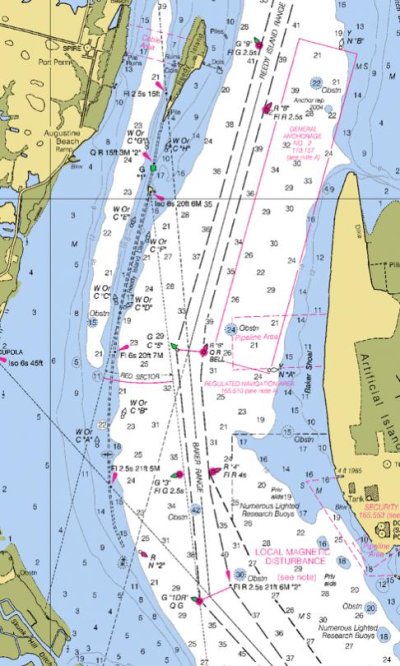
We will be running up the bay from Cape May to the C+D canal in about two weeks. I've done it a few times but not in 5 or 6 years. I've always had good weather and tides. Also have always run the ship channel but am looking for advice on wether the over the flats route is worth doing. It's shorter but I wonder about crab and fish pots, shoals etc. Thanks in advance.
 
Yes there's crab pots and oyster stakes, but better than fighting ship traffic if a busy day.

If you REALLY need the current push then the channel is your better bet.

Depending on boat speed, about 3 hours after low tide works best for me or a half hour sooner. You get most of it once past False Egg Island Point anyway....and running out to Brandywine I think is a split decision anyway.

I am leaving in about 3 weeks and follow the weather closely as I will pick weather or tide after balancing the good and evil of both.
 
Last edited:
I've only traveled the Delaware bay & river while staying in the ships channel because each of the 6 or so times I've done it I've been in a faster boat ,not a trawler, & short cuts weren't an issue (they certainly are now!). Regarding crab pots, on the Delaware as everywhere else,they're going to change location depending where the waterman are finding them that time of year. If you encounter a line of them at a certain depth, chances are they're going to be everywhere in that depth range. You'll probably be best off to wait until the date nears & see how the water looks at that time.
 
We went down and then back up Delaware Bay a couple weeks ago. Mostly the shortest route over 15' or more water depth. IOW, mostly not in the channel. Had the current mostly with us, each direction, transit times chosen for that on purpose. (Once weather dates looked good.)

We ran down on plane to Cape May, came back from Lewes at trawler speed mostly due to fog.

Didn't see many crab pots. Definitely stayed outside the channel on the way back up in heavy fog.

Had some useful conversations with a couple northbound container ships and a couple southbound tugs as we came back north. They all seemed to be surprised that a rec boat was also on Channel 13.

FWIW, we stayed at Delaware City on the way over there, and then at Chesapeake City on the way back. Decent marina and restaurants available at both places.

-Chris
 
Last edited:
There are crab pots but not like the Chesapeake Bay. Come out of the canal jetties and head for Miah Maul light. If you leave an hour after low tide at 7 knots, you will have a favorable current all the way to the C&D canal entrance. Any wind 20+ will be a crappy short chop, especially NW.
When you get to the ship channel, keep 13 or 16 on and watch behind you. The smaller freighters run 20 knots all the way up to the Delaware Memorial Bridge.
Have a safe trip.
 
Last edited:
Agree with all -
Play the wind and the tide together if you can.
You can come out of the CM canal and run in 15'+/- water and reach the shipping channel without issue. Don't stray to far east or you will be in REAL shallow water.
Crab pots on usually in a line that can be seen and you can run through.
Good luck
 
I went much of the way down the bay in the channel and the angled over to the channel into Cape May. No issues with deprh, although I didn't do it at low tide. Regarding crab pots, the crab season is mostly over. Doubt you will see many.

Ted
 
Yes there's crab pots and oyster stakes, but better than fighting ship traffic if a busy day.

If you REALLY need the current push then the channel is your better bet.

Depending on boat speed, about 3 hours after low tide works best for me or a half hour sooner. You get most of it once past False Egg Island Point anyway....and running out to Brandywine I think is a split decision anyway.

I am leaving in about 3 weeks and follow the weather closely as I will pick weather or tide after balancing the good and evil of both.
Fighting ship traffic? Geez, it's not like meeting or having to pass tugs with tows three barges wide on the Illinois River with just 30 yards on either side between the barge and the channel markers, several during a typical running day. The ship channel on the Delaware is PLENTY wide.
 
Semantics...I'm sure he could've used inconvenienced or troubled or hassled or another adjective. I guess his point was it is fine to run outside of the channel but you have to be on the lookout for crab pot buoys instead of ship traffic.
 
Or being contacted on the radio about my intentions.....whatever... I like to relax, not have to reach for the radio, and NOT get hit by 6 foot or more wakes from Reedy Point south...

But thats just me..... having towed through crowded, narrow parts of the ICW, yes I can manage to avoid the occasional commercial traffic in just my own single vessel AND look and sound professional about it...unlike many Delbay transient pleasure boaters being pleaded with by ships pilots for their intentions.

The OP did ask about transiting Delbay on the flats...which I do predominantly...and avoiding GIANT VLCCs just happens to be one of the added good things.
 
Last edited:
I generally stay out of the channel for the reasons given above and have made that trip a lot over the years.
John
 

Attachments

  • Screen Shot 2018-10-03 at 7.16.55 AM.jpg
    Screen Shot 2018-10-03 at 7.16.55 AM.jpg
    83.2 KB · Views: 193
Last edited:
That jetty catches a suprising number of people...yet.... I have no idea how unless they are trying to pass through it to get from/to the anchorage and never refer to a raster chart. AND..... then never identify the "gate" marks. Which is exactly what the Hatteras did wrong it sounds like.

It's kinda out of the way if you are just transiting.
 
Last edited:
<<and never refer to a raster chart>> There's a lot of that these days....

So where IS the proper entrance to the anchorage? The "1" and "2" just South of the island?
 
Last edited:
Yes....unless someone knows something new or different.

Just looked at the NOAA ENC chart viewer..... thats exactly why I use Raster charts until they put a log more work into any other type charts....that is as long as there IS a Raster for the area.
 
Last edited:
Yep, another one bites the dike. Its submerged at mid to high tide. Some charting formats show it solid, some as only dashed lines. If you are zoomed in too much or did not look at it ahead of time, it kind of looks like a cable crossing.
Hope Creek Jetty and Pea Patch Island dike are also similar submerged "frequent fliers" for the local rescue companies.
 
That's why I like Raster charts...clear, double dashed lines marked Reedy Island Dike...at all zoom levels...

Hard to miss.
 
The S57 chart of the area clearly shows the jetty, as do the paper charts, as do the electronic raster charts, as does our Garmin chart plotter (an older version). There's a lot to be said for having several chart sources when navigating unfamiliar water for the first time, or at the very least consulting a paper chart! Hard lesson learned. We've anchored behind Reedy Island at least a half-dozen times in the past 20 years of boating; the jetty has always been there, as has the marked break for getting through the jetty. It's a nice, fairly protected, place to spend the night.
 
“Just looked at the NOAA ENC chart viewer..... thats exactly why I use Raster charts until they put a log more work into any other type charts....that is as long as there IS a Raster for the area.”

Plus 1 on Raster charts. Sh** disappears on Vector charts. Just sayin.
 
The only reason to go through there is to anchor out behind Reedy. Did it once and there was a marked pass through on the dike. As I recall we had to wiggle through the northern channel to keep on our way. I liked anchoring over at the Cohansey better if wind conditions were right.
 
When you reach the northern end of Delaware Bat stay in the channel. Your original question was if it was prudent to run across the flats north of Cape May, and it is. However once you approach the Reedy Island Dike. stay in the channel. There is a very confusing red nun (#2) on the west side of the channel, at the bottom of the submerged dike (chart 12311). I have complained about this buoy several times to no avail. It is confusing at best, dangerous at worst. If you red-right-return at this mark you can very easily hit the dike.
John

I can't figure out the purpose of that #2 nun ,either, now that you mention it.
 

Attachments

  • 6234.png
    6234.png
    12 KB · Views: 168
  • 3117.png
    3117.png
    20.9 KB · Views: 166
Last edited:
Only thing I can think of is that it marks the end of the dyke for those wanting to go "in" and behind it.....
 
Only thing I can think of is that it marks the end of the dyke for those wanting to go "in" and behind it.....

Thats what the coast guard says. however the bouy is at least 75 yards from the end of the jetty and it is not in line with it. Further north in the channel is a green "3". If you've not travelled this before it can be confusing as there are marks all over the place including the main channel, the entrance to the canal, the Salem channel, etc. I asked them to relocate it to the end of the dike or actually put a lit mark on the end of the dike itself.
John
 
Thats the reason for the red bouy...makes sense to me if looking at a chart. You cant go by bouys unless you have observed on a chart what they mark.

If not anchoring behind the jetty and transiting from the Cape May Canal to the C&D Canal, there is no reason to ever leave the Jersey side (outside of the channel) till north of the power plant.
 
Last edited:
Thats the reason for the red bouy...makes sense to me if looking at a chart. You cant go by bouys unless you have observed on a chart what they mark.

If not anchoring behind the jetty and transiting from the Cape May Canal to the C&D Canal, there is no reason to ever leave the Jersey side (outside of the channel) till north of the power plant.

Exactly right. That marker is what you keep to starboard as you make the left turn off the main channel to get up to the west of the dike. I think the larger issue illustrated here is people who do not study the charts carefully ahead of time when doing route planning, and plot a route accordingly. Just winging it as you go in moment leads to bad results.
 
I'm not seeing how in the heck that red nun is in a good place to help anyone get behind the dyke. I could understand it lining you up to get behind the dyke if there was a #3 can on the other side to shoot for. It's too far offshore from the dyke to the north and what looks like exposed rocks to the south.
I agree with John. It seems more prudent to put the thing on the end of the jetty.
 

Latest posts

Back
Top Bottom