Current forecasts call for 20 to 30" of rain in the Myrtle Beach area. 10 to 20" throughout SC and parts of NC and 6 to 10" as far west as Charlotte. One argument those choosing to ride the storm out are using is the inability to get back to their home anytime soon after the hurricane. That's a valid concern, although I have a hard time saying a greater concern than being safe during the hurricane. I guess some of it depends on how sure you are your house can handle the storm and you have food and drink for up to a month.
You are using an out of date browser. It may not display this or other websites correctly.
You should upgrade or use an alternative browser.
You should upgrade or use an alternative browser.
Hurricane Florence
- Thread starter BandB
- Start date
The friendliest place on the web for anyone who enjoys boating.
If you have answers, please help by responding to the unanswered posts.
If you have answers, please help by responding to the unanswered posts.
twiisted71
Guru
- Joined
- Aug 8, 2011
- Messages
- 577
Thinking there it will be tough to find marinas able to pump fuel during the trip south this fall.
At this point, the least of any of our worries. We need to get through the next few days safely.
I wouldn't sweat that. If you haven't already, become a member of ActiveCaptain. Its a great site that members contribute local knowledge to. Often times area marinas and docks will also contribute. I would imagine a boat your size could easily pass through N&S Carolina with your onboard tankage. If need be a couple plastic 55 gallon drums of fuel onboard should give you plenty of reserve. No marinas and other infrastructure might be another issue entirely if you don't like anchoring at night or if you have any major issues.
cardude01
Guru
- Joined
- Nov 26, 2012
- Messages
- 5,290
- Location
- USA
- Vessel Name
- Bijou
- Vessel Make
- 2008 Island Packet PY/SP
What’s the prognosis for Hilton Head? My wife has an older relative who refuses to leave his home on HH. Son and daughter in Atlanta have not had luck getting him to leave.
Last time I was there during high tide the water was basically at his back patio/dock, which might be about 3’ off the ground. Seems like the storm surge from Florence could cause him big problems right? That and the lack of electricity for a week or so would be hard on an 85 year old man.
Last time I was there during high tide the water was basically at his back patio/dock, which might be about 3’ off the ground. Seems like the storm surge from Florence could cause him big problems right? That and the lack of electricity for a week or so would be hard on an 85 year old man.
sdowney717
Guru
- Joined
- Jan 26, 2016
- Messages
- 2,264
- Location
- United States
- Vessel Name
- Old Glory
- Vessel Make
- 1970 Egg Harbor 37 extended salon model
How frequently do you use it? Do you drain the tank when you know it will be a while before you'll use it again? Do you let your boat set for weeks/months at a time? Our boat could go for months without us needing the freshwater system as we used it for day trips far more than overnighting. Again everyone is different.
When I lived in the Keys, I'd see probably a dozen "boaties" a year come into the hospital with some form of live-aboard mold/fungus issue. You get so many who fall for the romantic idea of "chucking it all and running away to the islands and living on a boat". Problem is they don't realize that when you live-aboard you become responsible for many hygienic things that you took for granted living in a house with a city water supply and septic system, not to mention the oppressive heat and humidity that makes boats living on the hook like Nature's own pitre dish!
I only drain it for the winter.
We use it everytime we take the boat out.
We wash up with it, shower with it, cook with it, sometimes drink it. We use it just like we do our house water.
I every so often fill it up right from the slip dock.
The kids love to run the water hose in the boat, they use the water more than us but for play time. So it is us 2 grandparents, our kids, their 3 kids typically using the boat.
Honestly, copper sterilizes water, google it.
Most of my water system is copper pipe and brass fittings.
Our boat water has never smelled or tasted bad.
http://www.investmentwatchblog.com/copper-kills-99-9-of-bacteria-within-two-hours/
Copper…plain old Copper kills viruses and bacteria on contact!!! Copper pipes and pennies too???
EPA registers copper-containing alloy products
On February 29, 2008, EPA registered five copper-containing alloy products. The registration allows the registrant, the Copper Development Association (CDA) to market these products with a claim that copper, when used in accordance with the label, “kills 99.9% of bacteria within two hours.” This Web page explains the conditions of the registration and provides information on the pesticidal claims.
www.epa.gov/pesticides/factsheets/copper-alloy-products.htm
I have noticed boats with plastic water systems, the water can be foul. Turn on the water on one for sale, and the stench was unbearable. And if the water system lets in any light, that's bad as algae will grow. I have seen a few boats with clearish opaque tubing.
Last edited:
What’s the prognosis for Hilton Head? My wife has an older relative who refuses to leave his home on HH. Son and daughter in Atlanta have not had luck getting him to leave.
Last time I was there during high tide the water was basically at his back patio/dock, which might be about 3’ off the ground. Seems like the storm surge from Florence could cause him big problems right? That and the lack of electricity for a week or so would be hard on an 85 year old man.
Hilton Head is very much in the "We don't know" area. There is some greater degree of certainty as the storm hits and then moves south to Myrtle Beach. However, beyond that there is still a great deal of uncertainty as to how far it continues or when it turns inland and as to how much power it has as it moves south of Myrtle Beach. It may well not be known until Friday or Saturday. Hilton Head most likely to get 4 to 5 inches of rain and 2 to 4' of surge but it could easily be less or more. Charleston could get hit hard or escape with minimal damage.
menzies
Guru
Thought some of you might be interested in this video I made in our lock protected lagoon neighborhood during Matthew. And yes, I did get well panned for a) staying and b)going out in the middle of it! I will admit that when I tried to go out a second time and stuff started bouncing off the roof of the SUV, I quickly turned back!
Last time I looked the two things that stuck in my mind were the time to landfall and the spread in the models. It seems the time to landfall is longer now than it was this morning. Maybe she's backing up? Kidding.
The models are far tighter than they were a day or so ago but not as close as I expected by now. There is still room for adjustment. Not expecting much but maybe a little. Hoping for a little that helps.
The models are far tighter than they were a day or so ago but not as close as I expected by now. There is still room for adjustment. Not expecting much but maybe a little. Hoping for a little that helps.
Last edited:
O C Diver
Guru
- Joined
- Dec 16, 2010
- Messages
- 12,867
- Location
- USA
- Vessel Name
- Slow Hand
- Vessel Make
- Cherubini Independence 45
Don't know what the depths are close to shore, but waves break when they feel the bottom. My recollection is that when the height of the wave exceeds the depth of the water, it breaks. So, 80' waves are probably breaking and discharging their energy more than a mile off shore. They're not good for boats in the open ocean, but probably much less of a factor on land.They were saying (weather people) they saw 83' waves out there. Measurements taken by a satellite. That's a little steep. I wonder of there are any weather buoys out there when it gets closer.
Ted
For NC, Looks like a lot of water will be pushed up into New Bern, etc... that is where water goes I suppose, up a creek, being forced up by the hurricane and rain.
So when you go further inland, the storm surge gets worse than along the coast? And they kind fool you with the wording, storm surge is not including tides, so you have to add in the tide to surge to get a true height of water.
Daughter used to work at the hospital in Greenville, now is in Oregon. Greenville is flat land, like a pancake.
https://weather.com/safety/hurricane/news/2018-09-11-hurricane-florence-south-carolina
It can sure work that way. In Katrina, my wife's house, located on a bayou and with an elevation of forty feet, had three feet of water over the floor, with a storm surge that was only recorded as around 32 feet.
TowLou
Senior Member
I figure and believe they will go down. Just the power of this storm now and hearing they measured that is pretty neat. See tomorrow when it is here.Don't know what the depths are close to shore, but waves break when they feel the bottom. My recollection is that when the height of the wave exceeds the depth of the water, it breaks. So, 80' waves are probably breaking and discharging their energy more than a mile off shore. They're not good for boats in the open ocean, but probably much less of a factor on land.
Ted
Stall, churn, flood, waves and dump rain
Wilmington is a ghost town, light traffic, gas is available, and BigBloFlo is going to drop a lot of rain. Winds are down, thank God! If storm surge isn't epic, a lot of property will be spared.
Towed my boat 100 miles inland on Monday and put in in a warehouse at Fuquay Storage.
There are a lot of us feeling relieved that it isn't a strengthening Cat 4. That was spooky.
O C Diver
Guru
- Joined
- Dec 16, 2010
- Messages
- 12,867
- Location
- USA
- Vessel Name
- Slow Hand
- Vessel Make
- Cherubini Independence 45
While it appears the wind levels have dropped some, this is looking like another epic flood for Conway, Socastee, and the Waccamaw river area in SC. They went through this two years ago with a hurricane that dumped a tremendous amount of rain in the "Low Country".
Ted
Ted
FootballFan
Senior Member
Read a quote from a FEMA official last night (somewhere). I apologize if it was here and I am repeating something from a previous poster.
When asked about the weakening of the storm from some of the earlier projections, paraphrase of his response was:
It is good that the storm is weakening, however keep in mind it is the difference between getting hit by a semi truck instead of getting hit by a train. Both are bad.
When asked about the weakening of the storm from some of the earlier projections, paraphrase of his response was:
It is good that the storm is weakening, however keep in mind it is the difference between getting hit by a semi truck instead of getting hit by a train. Both are bad.
O C Diver
Guru
- Joined
- Dec 16, 2010
- Messages
- 12,867
- Location
- USA
- Vessel Name
- Slow Hand
- Vessel Make
- Cherubini Independence 45
This might make the snowbirding trip an offshore one from Morehead City to Charleston or Savannah.
Getting out around Cape Fear could be a treat!
Was thinking the same thing. I likely won't be there till November, so maybe things will be better by then.
Ted
Don't know what the depths are close to shore, but waves break when they feel the bottom. My recollection is that when the height of the wave exceeds the depth of the water, it breaks. So, 80' waves are probably breaking and discharging their energy more than a mile off shore. They're not good for boats in the open ocean, but probably much less of a factor on land.
Ted
Waves can begin to break for a number of reasons but when the relationship is to the depth of the water they will begin to steepen when the height of the wave is less than 3/4 the depth of the water. They will also steepen and begin to break when the height is greater than one seventh the wavelength which is more typical in wind driven storms like these.
Read a quote from a FEMA official last night (somewhere). I apologize if it was here and I am repeating something from a previous poster.
When asked about the weakening of the storm from some of the earlier projections, paraphrase of his response was:
It is good that the storm is weakening, however keep in mind it is the difference between getting hit by a semi truck instead of getting hit by a train. Both are bad.
The ability of buildings to withstand and survive the wind is increased by the decrease in the wind speeds. So, one of the three impacts to the area is not quite as bad. However, even on that one, we've seen a lot of wind damage previously in the storm area even from much lesser storms. Still a relatively new building or home has a better chance of withstanding the weaker winds.
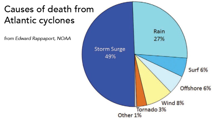
The other two impacts though haven't improved and that's the coastal damage from the surge and the coastal and inland damage from the rain and flooding.
Looking at recovery, it's hard to anticipate. You see areas like Fernandina where there is little sign of progress but then other areas hit more recently fully recovered. I thought FPL with a lot of outside help did a tremendous job in Florida last year. However, I don't know that the same can happen in SC and NC, especially with the number of roads that may be impassable. We've seen roads blocked for several days and even a week from much smaller storms. We're talking about dams in jeopardy far inland. Those around Columbia are still very vulnerable as are areas along all the smaller rivers running through both states. I recall after Matthew those who couldn't return to their homes for days. One other comment I heard serves as a warning too. The water that accumulates quickly in some of these areas isn't water for very long. It's very soon sewage. In some areas it may even be toxic waste. Then when it comes to recovery, most homes are covered by insurance on hurricanes. However, a smaller percentage have flood insurance and as you move inland it becomes a very small percentage. On top of that there are many areas facing this flood that are economically not strong.
caltexflanc
Guru
A big element that is getting ignored somewhat is the prolonged time this event will be taking place. In New Bern we will have +30 winds for 36 hours. And +40 (peaking at 75) for a day. Coupled with the rain and already moist ground, and a heavily wooded terrain, the damage from trees and limbs will be extensive, and I have little hope for our home surviving that.
A big element that is getting ignored somewhat is the prolonged time this event will be taking place. In New Bern we will have +30 winds for 36 hours. And +40 (peaking at 75) for a day. Coupled with the rain and already moist ground, and a heavily wooded terrain, the damage from trees and limbs will be extensive, and I have little hope for our home surviving that.
I do not know if you are still in New Bern or where your home is but please be safe.
Our concern in New Bern is storm surge - if you have not looked it up suggest you utilize the Slosh map version 2 and get a feel for the affects for that location. Again hope your safe as a few limbs can often be dealt with but surge and flash flooding are much different.
psneeld
Guru
Limbs?
Isnt that area pretty famous for tall, thick pines with a propensity to blow over due to small root balls and sandy soil?
My sister in Wilmington had one come down on her townhouse during one of the last, lesser canes. Its the only thing really worrying her this go around too.
Isnt that area pretty famous for tall, thick pines with a propensity to blow over due to small root balls and sandy soil?
My sister in Wilmington had one come down on her townhouse during one of the last, lesser canes. Its the only thing really worrying her this go around too.
Last edited:
A big element that is getting ignored somewhat is the prolonged time this event will be taking place. In New Bern we will have +30 winds for 36 hours. And +40 (peaking at 75) for a day. Coupled with the rain and already moist ground, and a heavily wooded terrain, the damage from trees and limbs will be extensive, and I have little hope for our home surviving that.
That's also going to influence the damage of storm surge where the peak surge will run through 4 high tides.
There will be homes that seem to survive the storm but then do get damaged heavily by limbs, trees, and other debris.
The other factor in damage to homes and property is the length of time before anyone can return to it to do any damage control. The damage to a window or roof may not be even seen for days or a week or longer. I recall the frustration of those on Hilton Head and other islands in that area when they couldn't get to their homes for so long. In 2015, after a storm, you couldn't get back to the coasts of SE NC or NE SC for days and that wasn't even a named storm.
There will be a huge impact too of those who find their livelihood destroyed. Entire towns will be shut down for extended periods of time. I saw an interview with the mayor of Carolina Beach and all I thought about was what we saw in Rockport, TX after Harvey. Homes, businesses, schools.
Was thinking the same thing. I likely won't be there till November, so maybe things will be better by then.
Ted
This area is very resilient. Unless there is undredged shoaling in the icww, November would be a lovely time to cruise through.
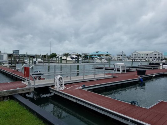
WB calm before the storm, about 2 hours before high tide today.
Attachments


psneeld
Guru
Undredged shoaling?
After Sandy, there were cars, trucks, homes, boats, docks, whole trees, shopping carts, tin sheds, regular sheds, etc...etc.... You name it, it was in the NJ ICW.
Can't dredge till that stuff is out and that took many months....
I am already planning how to bypass most of that ICW next month...hard for me, but doable...not looking forward to going out to the Frying Pan Shoals cut though.
Last edited:
Benthic2
Guru
Similar threads
- Replies
- 11
- Views
- 1K