Coastal Explorer 4.0 question

The friendliest place on the web for anyone who enjoys boating.
If you have answers, please help by responding to the unanswered posts.

Delfin

Grand Vizier
Joined
Jan 20, 2010
Messages
3,820
Can't say I like this upgrade, but CE is still pretty wonderful. One thing I can't figure out, and would appreciate info from other users, but I can get Active Captain or CE comments from other skippers to reliably display. I can't figure out why. Each is selected as a data source for "Places". Anyone with any ideas?
 
Garmin announced a few months ago that due to the European security rules, they were revamping their Active Captain database. AFAIK they have not released the interface specs to any third party developers. So no one can get Active Captain updates now.


Can't say why CE comments won't display. Maybe they are having to revamp their database to comply as well.


David

Thanks David, CE isn't sure what's going on either.
 
The last upgrade of CE included all the AC stuff......
 
Correct. I haven't tried it personally because I no longer use AC, but CE was among the first to adopt the new AC interface and get it all working again. You probably just need the latest update.

I have used it and it works just fine.
 
Interesting. I had CE do a remote and they can't figure out why the AC data doesn't show up.

Give CE a call. They are very helpful in helping you figure out issues like this.
 
While we are on the topic, I don’t like the new method with CE 4.0 for putting in a route. I use the quick route method, but I get a screen on the left hand side that shows waypoints and it takes up too much room and I loose too much of the chart. I find the process much slower than before. Any suggestions on this?
 
JD,

On the bottom of the screen where you see the "New" button, when you hit it there are two options for route, on the left you see "Route" and on the right you see "Quick". The "Quick" is the simple way to do a route without the information window coming up.

My Active Captain works fine after the update.


Tom
 
4.0 definitely takes some getting used to, but I've come to like it except for a few things. As I think Jim pointed out, a few of the information windows like the one that shows all the waypoints for a route are much less compact than they were in 3.0, and I find that makes them a lot harder to use. But I have mostly adapted as this point.
 
While we are on the topic, I don’t like the new method with CE 4.0 for putting in a route. I use the quick route method, but I get a screen on the left hand side that shows waypoints and it takes up too much room and I loose too much of the chart. I find the process much slower than before. Any suggestions on this?

Jim, you can drag the right hand margin of that window to the left a fair bit to reduce it. Quick route shouldn't launch it, but as soon as you add waypoints to the end of the route, it pops up. On a separate topic, we are on our way to Haida Gwaii, with your very kind trip notes in hand.

Still can't get Active Captain notes to show up, but perhaps I'll figure it out later, or CE will. They, like me, are stumped.
 
Have a great trip north! Wish I was coming!
 
I still have the previous version on my "standby" laptop and the big difference which confounds me is the lack of an "instrument" displaying time of arrival at destination. The "ETA" display is gor the next waypoint. Similarly, "DTG" is calculated to destination while "TTG" is to the next waypoint. I have tried the list of instruments to no avail; am i missing something?

Still love the program, and I am certainly capable of doing an 8-knot calculation in my head, but why would they remove this useful function?

Select Route Monitor from the instrument list.
 
<<Route Monitor>>

Well of course, Route Monitor! How blind of me to not see that.
:socool::facepalm:
I've installed it, but at dockside in Sitka, it's not saying much. Still doesn't address the DTG/TTG discontinuity.
 
4.0 definitely takes some getting used to, but I've come to like it except for a few things. As I think Jim pointed out, a few of the information windows like the one that shows all the waypoints for a route are much less compact than they were in 3.0, and I find that makes them a lot harder to use. But I have mostly adapted as this point.


I, too took issue with real estate distribution on the main screen in v4, it was a real annoyance since I liked it just the way it was. There are undocumented tools to change the size of the instruments, call them at CE, they'll help you out. I was on the phone a couple minutes, problem solved. You may also find some pointers on the CE net forum.

Don't shortchange the "screens" function, there is a LOT of functionality in being able to develop customized screens to include tools you use frequently.
 
Well of course, Route Monitor! How blind of me to not see that.

:socool::facepalm:

I've installed it, but at dockside in Sitka, it's not saying much. Still doesn't address the DTG/TTG discontinuity.


You can also right-click on the route and “show details”. You can then play around with vessel speed to see how that changes your ETA at waypoints. I’m not a big fan of the new “route details” window. I much preferred the old route details pane, which displayed each waypoint as a single line.
 
Jim, you can drag the right hand margin of that window to the left a fair bit to reduce it. Quick route shouldn't launch it, but as soon as you add waypoints to the end of the route, it pops up. On a separate topic, we are on our way to Haida Gwaii, with your very kind trip notes in hand.

Still can't get Active Captain notes to show up, but perhaps I'll figure it out later, or CE will. They, like me, are stumped.

On AC are you selecting the upside down tear drop thingeeeee?
 
On AC are you selecting the upside down tear drop thingeeeee?

What upside down teardrop thingie? Where the heck is that? When I had CE support remote in, they did what I did - check the box for AC in "Places", but it sounds like there is someplace else I need to go. Any help is appreciated....
 
What upside down teardrop thingie? Where the heck is that? When I had CE support remote in, they did what I did - check the box for AC in "Places", but it sounds like there is someplace else I need to go. Any help is appreciated....


I think he's talking about clicking on the place marker "pin" to bring up the active captain details. But if I follow correctly, you aren't even seeing the pins.


One thought. Do you have CE loaded on a second computer? The license is good for three computers owned by you. It might be informative to see if it works on a different machine, but still using your AC account.

Oh, that tear drop thingie....Yes, that is what I click on, but what is weird is that I'm not even getting Sailing Directions information. For example, if I put the cursor on Prince Rupert, click Places, I get nothing. If I move the boat to the harbor in PR a la dead reckoning, click Places, same thing. So the issue isn't just Active Captain, it's all relevant information. This happens both with the nav computer and my backup.

As happens too frequently, Rose Point's "upgrade" was two steps forward, three steps back. But, that is what I've come to expect from Microsoft folks....
 
Just for giggles, I downloaded and installed the latest update. No joy. Here is the image of Prince Rupert. CE can't find anything to say about this port.
 

Attachments

  • CE image.jpg
    CE image.jpg
    72.7 KB · Views: 31
Just for giggles, I downloaded and installed the latest update. No joy. Here is the image of Prince Rupert. CE can't find anything to say about this port.


You'll need to click on the place marker icon on the menu bar to show the A/C data. It's not like some other apps where the data is always visible. If that's not working, go to SETTINGS>ACCOUNTS>ActiveCaptain and make sure your AC login is current. You may need to head to the AC website to update your Garmin login as it now supplants the old ActiveCaptain login. The site has instruction on how to proceed with that changeover. Once logged in, you should be able to do a SETTINGS>sync now and it will download the current AC data. If that fails, head to the Coastal Explorer network forums for some other ideas, or simply call Rosepoint and they can talk you through the process. They are knowledgeable and helpful.


If you've used AC with CE in the past with success, and now can't see it, it's probably related to the old AC login vs. Garmin login. With the API changes in May, you must create a Garmin login for the sync to re-download the data. If you haven't visited the new Garmin site and completed the credentials exercise, it won't work until you do. If you've not re-synced and haven't seen the AC data downloading, you won't see data that's not there!

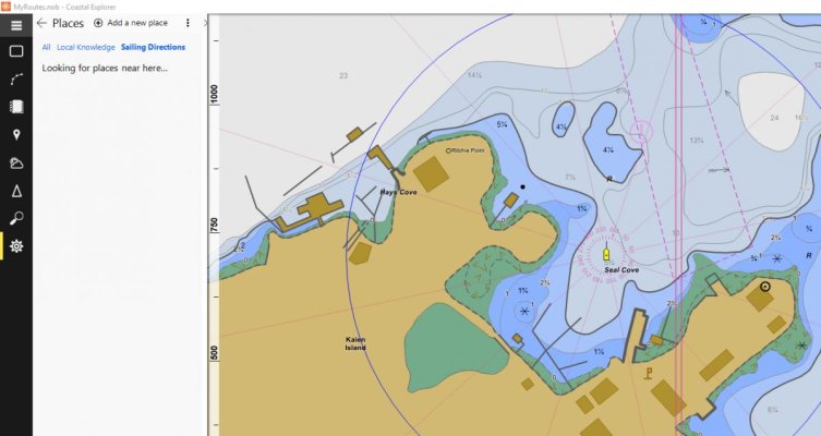
I'm on v4, the A/C data is showing up as before. You've missed something in the changeover.
 

Attachments

  • CE_places.jpg
    CE_places.jpg
    122.2 KB · Views: 29
Last edited:
Thanks Maerin, I'll try that when we get to Prince Rupert. Still doesn't explain why the sailing directions aren't showing up either, even though I have all days sources clicked.

And Alaska, I did do a remote with CE and he couldn't figure it out either, but suggested it MIGHT be what Maerin suggested, more or less.
 

Latest posts

Back
Top Bottom