Irish Rover
Veteran Member
- Joined
- Nov 27, 2017
- Messages
- 80
- Location
- Turkey
- Vessel Name
- Irish Rover
- Vessel Make
- Fountaine Pajot Greenland 34
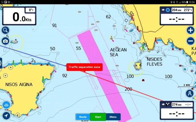
I have Navionics Boating HD app on my tablet and I was doing some pre-planning for an upcoming trip from the Ionian Sea to Turkey through the Corinth Canal. The Saronic Gulf around Athens is a particularly busy area and there is an established Traffic Separation Scheme there. I used auto-routing on the Navionics app and it has me crossing both lanes and the separation zone of the TSS at an angle of about 45 degrees. Surprised I e mailed Navionics and asked
"[FONT=Arial,Sans-Serif]If I set an automatic course does the course you plot for me take account of Colregs for instance in relation to traversing or crossing a TSS."
I got a reply yesterday which said
[/FONT][FONT=Arial, sans-serif]Dock-to-dock Autorouting takes COLREGS and TSS into account to calculate the route accurately and safely. It quickly creates detailed routes even through narrow waterways and channels, based on chart data and navigation aids.
[/FONT][FONT=Arial, sans-serif]I went back to them with a screenshot of the route and added[/FONT]
[FONT=Arial, sans-serif]"I had assumed your auto routing would take account of Colregs and TSS but when i used auto routing to plot a course through the Saronic from Corinth to the Island of Kea it has me crossing the TS line at an angle of about 45 degrees whereas Colregs require that " A vessel shall, so far as practicable, avoid crossing traffic lanes but if obliged to do so shall cross on a heading as nearly as practicable at right angles to the general direction of traffic flow". I would be obliged if you could explain this apparent anomaly".
They replied:
[/FONT]Thank you for the screenshot. This is certainly something that we will investigate further. If you could, please provide your start and end coordinates for testing purposes on our side. This way we can determine the best resolution. Thank you for your kind cooperation.
I'm curious if anyone else has had similar experiences with Navionics auto routing?