Bringing the Sea Star home from FL to LA

The friendliest place on the web for anyone who enjoys boating.
If you have answers, please help by responding to the unanswered posts.
This evening we fly home. Unfortunately, we won’t get home in time to pick up any crawfish but that’s what I’m having tomorrow.
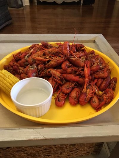
Crawfish season is my favorite time of the year. Well, it’s a toss up between crawfish season and football season.

First time I drove through rural Mississippi, I passed a big building with a crawfish sign. I thought it was a bait shop. I did not realize people ate crawfish. It was not until I saw them on a menu a couple of days later that I did. I'd never had a course in astacology. Now, I've since found out that almost all crawfish are harvested in Louisiana and the vast majority of them eaten there as well.

Oh, as to using them for bait, advised against now as zebra mussels attach to them.

I typically don’t eat crawfish anywhere other than south Louisiana. Some people can really mess them up, IMO.
David does a great job boiling them but it’s not worth it to do unless you’re having a crawfish boil and have reason to cook at least a sack.
The day after our wedding we are having a crawfish boil at our house because we have a lot of out of town family coming in. We will be buying them already boiled though instead of doing them ourselves. I can’t imagine we’re going to feel like cooking the morning after our wedding night :D:angel:
 
I knew which side the markers were supposed to be on. That was the first lesson David taught me. The problem was the green I was looking at wasn’t MY green...it was apparently a green for a cross channel or something. The green I should have been looking at was further in the distance and off to my nw a little. I didn’t even see it until David came up and pointed it out to me. So basically when I made that little curve I spotted that green and ASSUMED it was the one I was supposed to be following. That was my first mistake.


I know exactly where that happened and it is confusing. I crept around that bend at barely steerage speed til I spotted the ‘real’ green.
 
markers without a chart or local knowledge are meaningless till you establish where you need to be in reference to them.

one of the first things taught to me about navigation was that you are suposed to know where you are at all times....verifying it by gps, celestial, markers, buoys, etc is just icing on the cake.

thats why in piloting they call them fixes versus estimated positions.

so using marks is only a good idea if you are already sure its the one you want.

not directed at anyone, just a tidbit of several careers and a lifetime of navigation experience.
 
I know Jay, but for many following incomplete or hard to follow rules doesnt guarantee the colors are on the correct sides... :)

Just this thread alone is scary.... ;)


I must say that I like Jay’s red and green cap idea.

Listening to this discussion I think I would be nervous to cruise in that part of the world. If you dropped me in a boat on the ICW I would be pretty clueless.

Around here, it is is pretty straightforward, I is usually very easy to know if one is “returning” or not. The only place I have ever had given it any thought is in the one of the few navigable channels cut by man. The channel markers reverse about half way through and it is obviously marked on the chart.
 
Let's see.

Was that photo taken while running south on the Gulf ICW?

I was cruising down the Ct river on our annual "move the boat from the winter storage marina to the summer slip".
Travelling with the current is the only way I can make that speed.
 
I must say that I like Jay’s red and green cap idea.

Listening to this discussion I think I would be nervous to cruise in that part of the world. If you dropped me in a boat on the ICW I would be pretty clueless.

Around here, it is is pretty straightforward, I is usually very easy to know if one is “returning” or not. The only place I have ever had given it any thought is in the one of the few navigable channels cut by man. The channel markers reverse about half way through and it is obviously marked on the chart.

Not really, every channel intersection can have color reversal, but from NY to FL there are only a few to worry about.

Plus like I said, look ahead on the chart to confirm before you get tbere, no big deal....unless you are moving at 30 knots or better....then that can be a handful. :)
 
One note of caution. The rule of following increasing (or decreasing numbers) is true, so long as you are taking note of every number. If traveling at speed and perhaps not watching the numbers, the numbering system does reset. There is no set rule on when they do, though usually at a major inlet, or country line etc. So you may be at, say, red marker 48 going south and twenty minutes later see red marker 12.

If you start to get confused when crossing inlets or adjacent rivers there is another help available.

The AICW markers have yellow marks on them. Take note of these yellow marks on the day markers. A yellow square will be on the red markers and a yellow triangle will be on the green markers. If they ain't got yellow markers pull back on the throttles and have a good look around. You will be keeping the yellow squares to port and the yellow triangles to starboard travelling "south."
 
Last edited:
We should move these navigation posts to a new thread and not clog up a trip thread....but gotta stop the errors....

Yes marks can jump numbers, like exit numbers on interstates. Gotta know where you are and an occasional glance ahead satisfies most navigators. Numbering or studying the "placement" of the marks ahead is the only sure fire way I know of knowing which side they should be on.

you should be following the yellow shapes on the ICW....while 99 oercent of the time, the yellow shape will match what marker it is on, not always.

as a yellow triangle or square can be on either a red or green, thats why they are there as the primary color of the buoy may be marking the major channel and the yellow shape denotes the correct side of the ICW.

read a secrion of literature on buoys and markings, way too many misleading statements in this thread....

https://www.boat-ed.com/pennsylvania/studyGuide/Intracoastal-Waterways-and-Symbols/101039_101039090/
 
Last edited:
We made it home safely.
Now the countdown begins for our return to the boat for take II.
 
markers without a chart or local knowledge are meaningless till you establish where you need to be in reference to them.

one of the first things taught to me about navigation was that you are suposed to know where you are at all times....verifying it by gps, celestial, markers, buoys, etc is just icing on the cake.

thats why in piloting they call them fixes versus estimated positions.

so using marks is only a good idea if you are already sure its the one you want.

not directed at anyone, just a tidbit of several careers and a lifetime of navigation experience.

Serious question...not rhetorical.
How up to date are the charts? How often are they wrong?
 
What does the timing look like?

It’s looking like we can’t really get back until the 29th. IF it were ready by Friday of this week, AND we had a great weather window, we could possibly fly in Friday and leave Saturday but that would be pretty rushed.

Dang real life responsibilities getting in the way. Lol
 
Serious question...not rhetorical.
How up to date are the charts? How often are they wrong?

They're as up to date as you make them. You can download new charts today and they'll be current. Otherwise they will not be. They'll be as old as the length of time since you last updated them. You control how up to date they are.

How often are they wrong? After a major event, they may often be. Also depends on where you are. That's why notices to mariners are important, but also other tools such as Waterway Guide, Active Captain, Cruisers Net and Local Knowledge.

Then in areas of unfamiliarity, go in with extra caution and distrust. That means slow, observing.

One other thing not asked, "How often are your depth instruments inaccurate?" New boat to you, might be worth really checking out. Is 5' really 5' and if it is then how much is my draft and how much space does that leave.

Last, you ran aground or hit something. As no one has looked yet, you don't know what. However, it's something that happens. Don't let it make you overly fearful, just cautious. S... happens.
 
There is a lag on charts....from the time a marker is changed to the time it appears on a chart is my guess between a week or two, maybe even three most of the time.

Notice to mariners and NOAA electronic charts I think are updated or published weekly.

All usually good enough for safe navigation.

Wrong is a funny word in navigation markers....

A sandbar might be slightly larger and the tide might be exceptionally low, so bumping bottom inside a usually marked channel is not uncommon.

Yet there are plenty of marks that could be moved yet arent...just not feasible....and others that only dredging will help.

When traversing the ICWs, I usually make a list of known trouble spots I have been hearing about here. other forums and online guides.

Most I know about and many others arent really trouble, as they are incorrectly reported. There is usually plenty of water, but some manage to find sand or mud.....or worse.
 
Last edited:
They're as up to date as you make them. You can download new charts today and they'll be current. Otherwise they will not be. They'll be as old as the length of time since you last updated them. You control how up to date they are.

How often are they wrong? After a major event, they may often be. Also depends on where you are. That's why notices to mariners are important, but also other tools such as Waterway Guide, Active Captain, Cruisers Net and Local Knowledge.

Then in areas of unfamiliarity, go in with extra caution and distrust. That means slow, observing.

One other thing not asked, "How often are your depth instruments inaccurate?" New boat to you, might be worth really checking out. Is 5' really 5' and if it is then how much is my draft and how much space does that leave.

Last, you ran aground or hit something. As no one has looked yet, you don't know what. However, it's something that happens. Don't let it make you overly fearful, just cautious. S... happens.

Thanks. We definitely hit something. When it first happened and I posted about it, I had assumed we had just bumped bottom because it didn’t FEEL like much and there was no sounds that made me think it was something solid. My initial post about it was before we knew there was anything wrong. We still had a ways to go of idling in no wake zones and the problem didn’t become obvious until we tried to throttle up. Also I didn’t know that whatever we hit had killed the port engine. It started right back up but David didn’t tell me that part. I guess he didn’t want me to worry if I didn’t need to.

As for depth instruments, David said that’s something he wants to test, but there is a depth finder gauge and then the depth on the GPS. I’m assuming they each have their own transducer? They weren’t in perfect sync, but they were pretty close to each other at all times. I am also assuming that it’s telling us how much water is under the hull. When I had my little mishap, it showed for a little bit a depth of less than a foot and we never hit bottom or ran aground.

David used AC a LOT. He was on that and other places almost nonstop before the trip plotting it out. He had it open and running the whole trip on an iPad in addition to the GPS.
 
When I had my little mishap, it showed for a little bit a depth of less than a foot and we never hit bottom or ran aground.
.

Less than a foot is never enough to me. You seem so convinced you didn't hit bottom and it sure sounds like you did. Are you saying your depth finder showed less than a foot? Or the difference in what it showed and your draft was less than a foot? Regardless, if you were down to less than a foot clearance, you were already out of the channel. Notice I didn't say marked channel but any sort of a real, true channel.

I am Mr. Conservative when it comes to depths. I often plan trips using significantly deeper drafts than I have and find myself taking wider turns and going slightly more distance. I don't have to take the shortest route. To me it's like parking in a huge parking lot where there's one space up close but you'd have to squeeze in because the car to the right side is on or over the line. I don't do it. I'll find another space and walk. We may put on more miles than anyone else here but less shallow water miles. If I have a choice I don't select the marina that only has 5' depth if there's another with 8'.
 
Last edited:
you should be following the yellow shapes on the ICW....while 99 oercent of the time, the yellow shape will match what marker it is on, not always.

as a yellow triangle or square can be on either a red or green, thats why they are there as the primary color of the buoy may be marking the major channel and the yellow shape denotes the correct side of the ICW.

read a secrion of literature on buoys and markings, way too many misleading statements in this thread....

https://www.boat-ed.com/pennsylvania/studyGuide/Intracoastal-Waterways-and-Symbols/101039_101039090/

Okay, we must travel a small section (15 miles or so)of the ICW every time we leave our Canal. I have never seen a yellow square or a yellow triangle on any of those Day marks. I think I should pay better attention.
 
Less than a foot is never enough to me. You seem so convinced you didn't hit bottom and it sure sounds like you did. Are you saying your depth finder showed less than a foot? Or the difference in what it showed and your draft was less than a foot? Regardless, if you were down to less than a foot clearance, you were already out of the channel. Notice I didn't say marked channel but any sort of a real, true channel.

I am Mr. Conservative when it comes to depths. I often plan trips using significantly deeper drafts than I have and find myself taking wider turns and going slightly more distance. I don't have to take the shortest route. To me it's like parking in a huge parking lot where there's one space up close but you'd have to squeeze in because the car to the right side is on or over the line. I don't do it. I'll find another space and walk. We may put on more miles than anyone else here but less shallow water miles. If I have a choice I don't select the marina that only has 5' depth if there's another with 8'.

There are two different things I’m talking about. One when we were on our way from Sarasota to Tarpon Springs on Monday when I almost ran us aground. I veered out of the channel into very shallow water because I was focusing on the wrong green marker. The correct one was rather way off in the distance and I didn’t even notice it until David pointed it out to me once he got us back on course. I noticed right away that on both AC and the GPS that i was moving out of the channel and it confused me because again, i was focusing on the wrong green marker. We did not hit bottom there...which I think was just sheer luck because it was very shallow outside of the channel. David knew it was very shallow on both sides outside of the channel which is why he “reluctantly” let me drive so he could go ready lines and fenders. When I veered out of the channel, the depth finder showed less than a foot...like .9. Our draft is 3.5 ft. We were going pretty slow but in the moment I didn’t think to take it out of gear. When David came up he told me if something like that ever happened again, to take it out of gear.

The other was when we hit whatever we hit. That was early Thursday morning leaving turtle cove to be on our way to the gulf. The people that work there told us we should be ok even at low tide we just needed to be careful and go slow which of course we were. Had it not been low tide, there would have been more water and maybe we would have missed whatever we hit. It was definitely upsetting and disappointing having to abort the trip, but we realize that stuff just happens sometimes.

I honestly don’t know anyone more conservative or cautious than David. Especially when in an unfamiliar place. To the point that i often think he’s TOO cautious. I think that’s why compliment each other well. Lol
 
Yum. Lunch.
 

Attachments

  • 2594388D-E964-47AF-89EC-56B31844574A.jpg
    2594388D-E964-47AF-89EC-56B31844574A.jpg
    128 KB · Views: 44
When I veered out of the channel, the depth finder showed less than a foot...like .9. Our draft is 3.5 ft.

That's where you need to check the depth finder settings to see if it's set to depth of water or depth below lowest point. That's a matter of preference but we always go with water depth. Sounds like yours must be depth below or it couldn't get to .9.
 
Or could be depth below the transducer, which will be somewhere between water depth and lowest point of boat.
 
Hmmm, let's say the transducer is 2 ft above the bottom of the keel. Now, let's say, to be safe, you want 4 ft of good water below the keel. So now we want to adjust the alarm to 6 ft. Do we adjust the alarm 6 feet + or -?
 
Hmmm, let's say the transducer is 2 ft above the bottom of the keel. Now, let's say, to be safe, you want 4 ft of good water below the keel. So now we want to adjust the alarm to 6 ft. Do we adjust the alarm 6 feet + or -?

I would be setting the depthfinder keel offset reading at minus two feet and reacting (alarming) when it shows four.

However, a good number of our members have running gear hanging below the keel, you may want to set your reading to bottom of boat rather than keel.

Then when you set the alarm, which is different from your offset reading, can be set at whatever true under the vessel clearance you feel comfortable with.
 
Last edited:
We will definitely verify as soon as we can. David had the low water alarms set to 5 ft. Just to be on the safe side.

I think “my” preference would be for it to show the amount of water from the lowest part of the boat to the bottom. I wanna know how much water I have under the boat.
 
Congratulations! It sounds like an amazing trip. How about some more pics of the boat?

Cheers!
 
Congratulations! It sounds like an amazing trip. How about some more pics of the boat?

Cheers!

It is almost impossible to take pictures of your boat while underway.
 
Back
Top Bottom