Hurricane Irma

The friendliest place on the web for anyone who enjoys boating.
If you have answers, please help by responding to the unanswered posts.
Make some phone calls. You may find gas more easily going across on Interstate 75 and up the West Coast.

Ted

Here's a resource to use as well.

GasBuddy Gasoline Availability Tracker

Now, availability is only as reported to them so normally their tracker has very little information. Type Dallas, TX or even Houston, TX and you'll see what it can look like.

Type Fort Lauderdale and you'll get a lot of information. It looks like about half the stations have gas here so you can imagine the lines.
 
Or ask a friend with a center console and 200 gallons of gas in his tank.

Buy 30 from him at top dollar... :)

Times like this.... my survival training and natural scounging instincts take over....

You know how much gas will be sitting in wrecked boats come Monday? :)
 
Or ask a friend with a center console and 200 gallons of gas in his tank.

Buy 30 from him at top dollar... :)

Times like this.... my survival training and natural scounging instincts take over....

You know how much gas will be sitting in wrecked boats come Monday? :)

500 gallons in our center console. It's up New River at the condos of some employees of ours. RIB's here in our garage. Part of the plan if roads aren't accessible. Comes with living on islands which essentially all these areas with canals are.
 
Or ask a friend with a center console and 200 gallons of gas in his tank.

Buy 30 from him at top dollar... :)

Times like this.... my survival training and natural scounging instincts take over....

You know how much gas will be sitting in wrecked boats come Monday? :)


That's a really good idea.
 
Thanks Guys,

This house was not here in Andrew. I was able to fill my truck from the boat and 5 gal extra in a can. That would take me around 400 miles north. There was no storm surge to speak of in Andrew. There was not much flooding here in Homestead in Andrew. In a worst case, I am not sure how this newer two story town house would survive. It is two story so that fact is a plus in rising water.

I think all bets are off if I was actually hit with a cat 5 with winds of around 180 mph. God only knows what the gust would be. 20 feet of storm surge would likely put water in the first floor...how much who knows. We also have a near full moon which could add another foot of normal water. I don't have any confidence that any house would likely be standing when hit with 180 mph wind and gust that could exceed 200 mph.

As I write this, I think I will finish the work here this afternoon and leave. I think I will go through the center of the state and keep heading north.

I also think today is the last chance to safely try to get out of south Florida. With the forced evacuation of the keys taking place today and the strong possibility of Miami Beach and other coastal areas requiring evacuation tomorrow the roads out of here will be a night mare and truly dangerous.

Andrew was a very different hurricane even though similar winds. Andrew was tight and fast and very little surge for it's size. Irma is very wide right now with tropical storm winds or better for well over 100 miles width. It does have considerable surge at this point.

Now at the time of US landfall we're not talking 180 mph winds, perhaps more like 145 and that's only in the area directly hit.

If the house was built post Andrew, it's probably to new code and is supposed to handle up to 140 mph or so.

Your moving north is probably sensible considering Homestead's potential for flooding.

The models are slowly consolidating. Now each model itself isn't one model but comes from an ensemble of models they create. Right now GFS runs just offshore the Florida east coast and makes landfall near the GA/SC border. UKMET and AEMI now make landfall in South Florida. I know at least one of the two was running off the coast earlier. HWRF makes landfall is SC. HMON skirts the FL coast and makes landfall near the GA state line. They're consolidating a great deal though into showing a picture of either just offshore or on shore on the entire east coast of FL and continuing to GA or SC and perhaps to NC.

Miami Dade is opening several of it's shelters by 5:00 PM today.
 
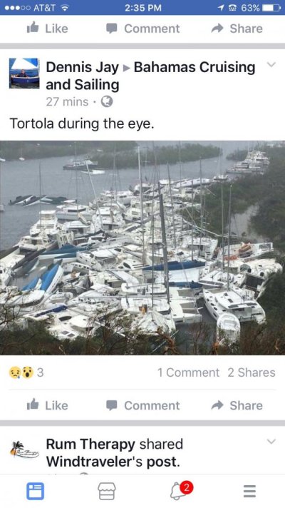
Paraquita Bay, Tortola....Not the best hurricane hole. Sad.

IMG_0928.jpg
 
Just got notice from my Marina to move my boat out. That was a fun conversation. Lifts in Savannah are booked out already. I'm on face dock :/
 
Just got notice from my Marina to move my boat out. That was a fun conversation. Lifts in Savannah are booked out already. I'm on face dock :/

If possible, can you take your boat up the Savannah River 60 or so miles, find a sharp bend with high banks and trees?

Thats where I would be headed.
 
If possible, can you take your boat up the Savannah River 60 or so miles, find a sharp bend with high banks and trees?

Thats where I would be headed.

I've not navigated far up the sav river before and was told last night by a local its fairly hazardous once you get about 8 miles in (and i'm already 5 miles from coast) ... plus taking it up river would risk my persons and pets so not going to do that...
 
Just got notice from my Marina to move my boat out. That was a fun conversation. Lifts in Savannah are booked out already. I'm on face dock :/

What will they do if you don't move it?
 
Looks pretty easy for at least 20 miles, probably way more.

I understand about family, so your call, but if I was in Savannah, looks pretty good to me.
 
What will they do if you don't move it?

Good question - as far as I see it, nothing except have a CYA if they need to sue my insurance company for damage caused by my boat...

I was able to just now secure a more protected temporary on-water spot at thunderbolt marina.

I'll move it over friday am (have to fly home first... am in MN) and prep it, board up my business buildings and then put the pets in the RV and head inland if necessary, assuming I can still get gas for the truck. The good news about Savannah is the local population is quite small as long as tourists have left there should be plenty of bandwidth on I-16 to get folks out.
 
Just got notice from my Marina to move my boat out. That was a fun conversation. Lifts in Savannah are booked out already. I'm on face dock :/

Floating or fixed? How tall are the pilings? What was the reason they gave?

I know surge is a major potential issue in Savannah with over 9' surge on the models even on a CAT 2.
 
Good question - as far as I see it, nothing except have a CYA if they need to sue my insurance company for damage caused by my boat...

I was able to just now secure a more protected temporary on-water spot at thunderbolt marina.

I'll move it over friday am (have to fly home first... am in MN) and prep it, board up my business buildings and then put the pets in the RV and head inland if necessary, assuming I can still get gas for the truck. The good news about Savannah is the local population is quite small as long as tourists have left there should be plenty of bandwidth on I-16 to get folks out.

I spent a winter in Thunderbolt back when Palmer Johnson owned it, we were tucked in ok, haven't been recent
 
Floating or fixed? How tall are the pilings? What was the reason they gave?

I know surge is a major potential issue in Savannah with over 9' surge on the models even on a CAT 2.

reason: "Its their policy".

Savannah tides are enormous for the latitude, ~9'. marina pilings (floating dock) are ~4' higher than high tide.
 
reason: "Its their policy".

Savannah tides are enormous for the latitude, ~9'. marina pilings (floating dock) are ~4' higher than high tide.

Honestly, I'd be concerned about 4' if they end up getting hurricane impact. I'd be more comfortable with Thunderbolt than most other Savannah marinas. We dock downtown but not during a hurricane.
 
What I was thinking. 4' doesn't sound like much to allow for surge.
 
I've not navigated far up the sav river before and was told last night by a local its fairly hazardous once you get about 8 miles in (and i'm already 5 miles from coast) ... plus taking it up river would risk my persons and pets so not going to do that...

Local is very wrong. I just took 20'draft up Savannah river 18 miles from Jetties. Container berths (ships ) are 20 miles up. Not sure above container docks but I bet it is a wonderful hurricane hole.
 
Local is very wrong. I just took 20'draft up Savannah river 18 miles from Jetties. Container berths (ships ) are 20 miles up. Not sure above container docks but I bet it is a wonderful hurricane hole.

Agree unless the charts are that wrong.

But with 9 foot tides, I bet getting 15 to 20 miles up would be doable without a doubt.
 
20 miles is done every day all day by container ships and car carriers....thats where the terminals are. above downtown Savannah by several miles. ICW crosses Savannah river way below town.No tide considerations for yachts until above commercial docks.
 
We love Savannah and love taking our RIB and exploring way up the river and all around the islands. Still, I'd personally choose Thunderbolt based on what I know. I haven't, however, carefully evaluated them for surge of this possible amount.
 
Re: Spaghetti Models

No idea. The Answer Man for all things Weather is Richard on Dauntless. I will say that the Weather people were very accurate about Harvey.

When I heard CNN say 'the European Model' I thought they were talking about our First Lady.


In Savannah, we are freaking out. 30 years nothing serious, now two in a row. Hoping for best, preparing for worst.
 
In Savannah, we are freaking out. 30 years nothing serious, now two in a row. Hoping for best, preparing for worst.

The accuracy of models will start to improve dramatically the next two days. 4 and 5 days out the normal miss is quite substantial. The average NHC track errors at days 4 and 5 are 175 and 225 miles.

Barbuda suffered huge damage although the reports of 90% rubble may be high. The photos we've seen really remind us of what we saw in Rockport. Puerto Rico with severe damage although not a direct hit.
 

Latest posts

Back
Top Bottom