The Magenta Line

The friendliest place on the web for anyone who enjoys boating.
If you have answers, please help by responding to the unanswered posts.

tadhana

Guru
Joined
Jul 23, 2011
Messages
596
Location
USA EAST
Vessel Name
Tadhana
Vessel Make
Helmsman 38 Pilothouse
Many cruisers still do not understand the purpose of the "Magenta Line" on the ICW. Many boats have run aground in the ICW but the skipper has tried to claim innocence. "But, I was on the Magenta Line!"

The magenta line is not a chart plotter route! It was first drawn in 1913! Its purpose was merely to guide vessels along the rivers, sounds and channels which are interconnected. It was intended to be nothing more than a way post showing you when to turn into a certain river or sound. It was not a specific chartplotter route. (Chartplotters were not very accurate in 1913.) Several times I have commented that slavishly following the magenta line like a chartplotter route, will run you aground. Here is a recent article describing a grounding accident when a cruiser thought the magenta line could be used like a chartplotter route.

https://www.passagemaker.com/trawler-news/navigation-charts-icw-magenta-line
 
There are several places here in southern New Jersey where the magenta line runs outside the marked channel over very shallow waters. Eyeballs have priority.
 
Anyone that believes the magenta line needs to stay home and play video games or be prepared to meet the bottom.
 
Greetings,
Ah, the magenta line cruising association. The reason tow insurance was invented.

We were doing a delivery trip one March and crossing the Albermarle Sound. My BIL (An official "Captain"-6 pack) had taken over the helm while I lay down in the saloon and rested my back. He ran us onto a rocky reef while following the magenta line. I took over the helm in short order but I had no idea where we were in relation to the reef so I backed off whilst hoping for the best. No damage done.

In his defense, he is an excellent boat handler, far, far better than I am, and I put his slight "oopsie" down to the fact that visibility was less than 1/4 mile due to a very heavy snow squall and no marker or anything other than white was visible BUT that good ole' magenta line was right there on the GPS. At the onset of the squall we slowed from our 8kt cruise to 4 kt so that probably helped as well.

I usually, somewhat follow the magenta line for general reference only and I consider it a vague suggestion, at best.
 
I dont follow the magenta line, but I do like it for a guick glance to where the ICW is going.
 
Both Senor RT and Scott hit the nail on the head. Magenta line is just a guide as to where to go such as turns but you MUST follow the markers which should keep you safe fir the most part. I found this out the hard way while traveling the ICW from Miami to the world's fair in New York in 1964. An older more mature Captain schooled me in no uncertain terms. :)
 
Here is the defense: If you're following the magenta line and hit a sucken boat is the chart manufacturer liable? Most people would say no as the wreck likely occurred after the chart was drawn. To that point you have to assume that everything and anything on the chart is subject to change.

Further, running aground is a fact of life when traveling the ICW. In a waterway that requires navigation aides to keep from running aground, clearly the boater was traveling at an unsafe speed considering the waterway.

Personally I like and use the line on my Garmin plotter as a general reference. Does the plantiff want all the navigation aides removed also as there positions are only approximate and not exactly correct on the charts?

Ted
 
When following the markers on the ICW you will at times glance at your chartplotter and find that you are cruising on land. Now how cool is that?
 
Howard

Real cool until you come to an abrupt stop. LOL
 
There was a discussion several years ago, when the magenta line was removed, that the magenta line should be more of a magenta highlighting that is wider, and perhaps change to a different color where there are no-wake / 6 knot zones. The argument against was the markers sometimes move, and folks really need to get their head out of the chartplotter.
 
HUH???? Forgive me, but most tight navigable waters have markers/buoys. For instance the "Christmas Tree" aka Wrangell Narrows has lots and lots of markers and red and green buoys.
 
HUH???? Forgive me, but most tight navigable waters have markers/buoys. For instance the "Christmas Tree" aka Wrangell Narrows has lots and lots of markers and red and green buoys.

There are markers on the ICW, but the next one might be around a creek corner and there is more than one option to turn.

While true constant attention might make it more difficult to miss the correct direction to turn, my guess is that many would like the simple pleasure of glancing at some kind of marking on the plotter that defines the ICW till the next mark is in sight.

I certainly like low stress, low thought cruising as I have spent a lifetime of navigating my way around roads, waterways and airways.....time for relaxation, not concentration.

We are talking a charting feature similar to coloring major highways a different color so at a quick glance, you know which road is which. You still have to navigate and keep the car on the road....its just a simple chart feature.

Anyone that has been cruising for a bit knows the majenta line stopped being a precision navigation tool decades ago, if ever. It took internet forums to suprise me that the magenta line actually ever suggested the strict path to follow versus nav aides...and some boaters actually did follow it. :eek:
 
Last edited:
There are plenty of boaters that still don't have the slightest clue what red and green channel markers mean. We should thank them. They are what makes commercial towing services like TowBoatUS and SeaTow economically feasible.
 
Anyone that believes the magenta line needs to stay home and play video games or be prepared to meet the bottom.

All that has been said is true - but only with respect to the one drawn on local guide charts. However, most, if not all, GPS plotters can leave a magenta line marking where you yourself have safely (presumably) traversed, and I do find leaving that there for a time, and following it if traversing that same route at a later date as helpful, assuming tidal effects don't affect the draft depth too much. :)
 
I live near a junction where it's not really clear if you should take a turn to port (when heading south) or continue straight ahead. I have watched boaters (cruisers) take the port turn and then a half hour or more later come back up the river and go the other (straight) way. It's confusing by the markers but clear on a chart or plotter with the magenta line.


I learned years ago that what you see in front of you with your own eyes takes precedence over what the chart plotter shows.


The magenta line has its purpose but it comes in at #3 after what you see and what the markers indicate.
 
SO a friend of ours owns a towing service the corporate name is Magenta life Inc
 
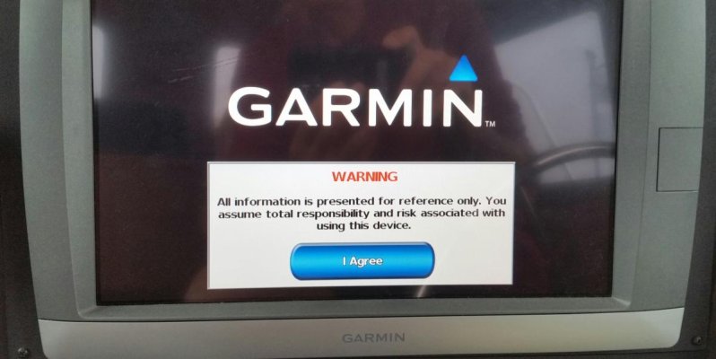
Guess he didn't bother to read the warning that has to be acknowledged every time you turn the plotter on.

2017-07-24 08.32.50.jpg

Ted
 
Damn that's annoying.
 

Latest posts

Back
Top Bottom