Silting in Petaluma

The friendliest place on the web for anyone who enjoys boating.
If you have answers, please help by responding to the unanswered posts.

mfreeman_1998

Member
Joined
Jul 16, 2008
Messages
23
Location
USA
Vessel Name
M/V Patience
Vessel Make
1978 Californian 38' Trawler
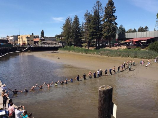
The winter storms of 2016-2017 have had a very negative impact on the Petaluma turning basin as well as the marina.

Water depths in the Turning basin are 18 inches to 3 feet max at low tide. Boats in the Petaluma Marine are also finding they are sitting in mud during much of the tide cycle.

Please be cautious about visiting either location unless you have a very shallow draft vessel. Local boaters are trying to increase pressure to get overdue dredging to occur.
 
Much of the turning basin was shallow in the past. The Petaluma Yacht Club's newsletter only mentions some shoaling on the north side of Haystack Crossing (Hwy 101).
 
Have the boaters take the initiative and contact Dutra Dredging in Rio Vista for quotes, and present them to the Petaluma city council. Back it up with data on the number of recreational boats in SF/Delta, and the potential revenue opportunity if just a percentage were to visit the Petaluma/Napa area by boat.
 
I understand Petaluma YC cancelled their annual Memorial Weekend bash because of it. Really a shame - we love Petaluma!
 
I understand Petaluma YC cancelled their annual Memorial Weekend bash because of it. Really a shame - we love Petaluma!

Welcome to the forum, davestic! Good to have a local with us.
 
Photo of Petaluma Turning Basin

Yes, Petaluma Yacht Club did cancel their Memorial Day Event. There is a very low tide that weekend and water depths were expected to be in the range of 18 inches.

Attached is a photo taken this weekend showing the extent of the silting.
 

Attachments

  • TurningBasin-PetalumaApril2-2017.jpg
    TurningBasin-PetalumaApril2-2017.jpg
    155 KB · Views: 159
That photo is extremely clear about how bad the water depths have gotten. Like Acheron posted above, I'd get the YC together and do the research and present it to the city council and ask them for their help. It may take months or years to get a dredging permit, but something must be done or those boats will all leave the area.
 
In 1956 my folks kept a boat at the Palo Alto Yacht Club. At that time the low tide entry situation was iffy. By the late 1960s the Palo Alto harbor had pretty well silted in. By the 1990s the area had become hiking and bird habitat.

This silting in is the nature of bays and estuaries world wide. In south SF Bay it is a given that over the next few decades the silting issue will dry land many more marine areas. This is Mother Nature at work and complicated by a rising land mass to the east of the Santa Cruz Mtns. Blame it on continental drift.
 
This is a total bummer. Petaluma now gone, on top of semi-lowered railroad bridge blocking me from going up the Napa River beyond Edgerley Island. :banghead::banghead::banghead:
 
This is a total bummer. Petaluma now gone, on top of semi-lowered railroad bridge blocking me from going up the Napa River beyond Edgerley Island. :banghead::banghead::banghead:

I'm not sure if you'd know but did they finish the dredging up to downtown? I wonder if the rains impacted the river up steam.
 
I'm not sure if you'd know but did they finish the dredging up to downtown? I wonder if the rains impacted the river up steam.

I've no clue. Cannot now get beyond the RR bridge. No issue up to that point.
 
Last edited:
Has anyone gone up the Napa River? Wondered if they have similar silting conditions...
 
The Napa is an actual river. It can carry most of its load of sediment down to the Carquinez Strait. The Petaluma is not a river; just a tidal estuary which rises and falls with the tides. Hence, it won't transport its sediment load with the same efficiency as the Napa or other true river systems.

The Petaluma has to be dredged mechanically.
 
In 1956 my folks kept a boat at the Palo Alto Yacht Club. At that time the low tide entry situation was iffy. By the late 1960s the Palo Alto harbor had pretty well silted in. By the 1990s the area had become hiking and bird habitat.

This silting in is the nature of bays and estuaries world wide. In south SF Bay it is a given that over the next few decades the silting issue will dry land many more marine areas. This is Mother Nature at work and complicated by a rising land mass to the east of the Santa Cruz Mtns. Blame it on continental drift.

I thought water levels were rising because of global warming and melting of the polar ice caps. Which one is it? :rolleyes:
 
I thought water levels were rising because of global warming and melting of the polar ice caps. Which one is it? :rolleyes:

The truth is...we'll all be dead before we know the answer to your question. Geologic time is not the same as human time...no matter how much we want to solve all the problems within our measily short life spans!
 
WesK

The Farralon Is were a mere 12,000 years ago connected to the mainland. They have subsided several hundred feet during that time. The land to the east of the central CA coast is continuing to rise, which is why the great inland sea that at one time stretched down to Stockton if not further is now a great crop area. Flat and with great soil.

Of course the sea is changing in elevation too, but in relation to what? Land masses are moving up and down, ice ages come and go, government grants keep tens of thousands employed evaluating global warming - fascinating stuff.
 
This is a total bummer. Petaluma now gone, on top of semi-lowered railroad bridge blocking me from going up the Napa River beyond Edgerley Island. :banghead::banghead::banghead:

Mark,

We drove past the Brazos Railroad Bridge the other day. It appears the lift span is currently set as high as it will go. You're back in business!
 
:dance:
 
Back
Top Bottom