psneeld
Guru
They are identified on the charts
I saw that in some Canadian pubs...but can't find anything down here for us heathens...

They are identified on the charts
I saw that in some Canadian pubs...but can't find anything down here for us heathens...
They are marked on my charts of the US east coast.

OK I will bite...US charts?
If so, can you please show me one?
And this is no pissing contest..I have never seen a classification published for an inlet and I would like to know why I am missing them.
I would be happy to show you but my chart drawer is under one helluva pile of tools at the moment as my entire helm station is torn apart fighting another issue. See my post on another thread about the mess I am dealing with right now
OK I will bite...US charts?
If so, can you please show me one?
I'm interested as well. Good to know know these things!
If you are contemplating using an inlet that is not particularly well marked, you ought to look at the crowd sourced charts from Navionics Sonar Charts. I have been using them for a couple of years now and have found that they are pretty good. Much more up to date and much more detail than the NOAA charts. You cannot take this data as absolute, but it is still pretty good and is a very helpful tool in places that NOAA has no coverage.
The Corps of Engineers Hydrographic surveys are much more current and detailed for key inlets and waterways than NOAA, who waits to update based on some variety of COE soundings. Here is some North Carolina and South Carolina for instance. Keep in mind COE's "customer" is commercial navigators, and drives decisions on what gets dredged when. There is a wealth of other info on the various districts' sites.
Thank you. Yes I use these sites regularly, and have done so for the past few years. . But this is only a good starting point. It does cover some sections of the ICW but not all of it and it does not do anything off the ICW. And some of it is not that current either. And its scope is very limited. As a wide ranging cruiser, I have found that this is a good reference, but only that. If you can have updated hyrographic data on your chart plotter, it is much more convenient than studying these PDFs. I work with Navionics to collect data in some trouble spots. This approach is the coming wave in hydrgraphic data collection and NOAA has now joined this crowd sourced data collection party. Right now they are far behind Navionics who is at this time the world leader in this data collection.
I don't recall seeing a list either, but have heard the term Class A used many times. I kept my own informal list of inlet grades based on my own rough and admittedly imprecise criteria, but based on direct experience (60ft LOA, 5ft draft, twin engine "semi-displacement" hull.
Class A: Entrance to a shipping port and/or naval base actively maintained by the Corps of Engineers and USCG as necessary:
Portsmouth, Boston, Narragansett Bay, Long Island Sound, New York Harbor, Delaware Bay, Chesapeake Bay, Beaufort inlet, Cape Fear River, Winyah Bay, Charleston, St Simon/Brunswick, St Mary's, St Johns, Canaveral, Ft Pierce, Lake Worth, Ft. Lauderdale, Government Cut, Key West.
Class B: Very actively used by smaller commercial vessels such as fishing, tour/casino boats etc and large pleasure boats, lower priority on maintenance by the government, but reliably passable by boats such as ours. Some examples would be Merrimack River/ Newbury Port, Plymouth, Fire Island (borderline C) Manasquan, Absecon, Cape May, Ocean City, Barden Inlet (Cape Lookout Bight), Masonboro, Little River, Edisto/Kiawah, Beaufort River, Hilton Head, Wassaw Sound, St Augustine, Ponce, St Lucie, Haulover, Cape Florida/Key Biscayne, Marathon, Bahia Honda, Channel 5.
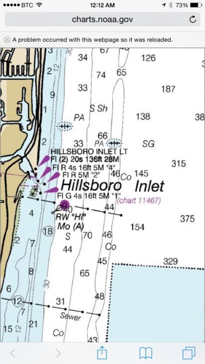
Class C , busy with small boat traffic, a little trickier than B's, often because of constant shoaling shifts, doesn't hurt to get some local knowledge, are sometimes closed by the USCG. Some examples: Westport Harbor, Moriches (borderline D), Barnegat, Little Egg, Indian, Rudies, Oregon, Hatteras, Murell's, St Catharine's, Sapelo, Doboy, Sebastian, Hillsboro, Angelfish Creek
Class D, very tricky, local knowledge essential, personally, no thank you!
A few examples: New River, Bogue, Topsail, Lockwood's Folly, Jupiter
An ability to run inside or outside gives you lots of options and variety.
I ran the outside route from Southport to Charleston at night early this year. We left the inlet before sunset, turned right, and timed our travel speed to arrive at the Charleston sea buoy around daybreak. Running at 9 to 10 knots, it was a low-stress way to travel. Ocean traffic after dark is nearly non-existent.
Obviously, you need crew that can stand watch (and stay awake). If the weather is good, and your kids can sleep on the boat, it's an easy trip.
Southport to Charleston is a good example. We normally go to Myrtle Beach because of family, but unless there was something inside or some place inside we wanted to see, we'd always go outside from Southport to Charleston. Normally for us, it's from Bald Head.