Anyone use Sirius Weather?

The friendliest place on the web for anyone who enjoys boating.
If you have answers, please help by responding to the unanswered posts.

dhays

Guru
Joined
May 26, 2015
Messages
9,045
Location
United States
Vessel Name
Kinship
Vessel Make
North Pacific 43
My boat is equipped with a Sirius weather receiver that is tied into the RM plotter. I am considering subscribing. Anyone use this service?
 
We have used it on our sailboat in the past. If you are away from cellular coverage for extended periods it can be helpful. For example, when we did our Bermuda racing it was a great source of weather info (yes, coverage extends as far as Bermuda...).
Not sure I'd find it so necessary for coastal cruising though as my cell phone can access the information more quickly. We have activated it for coastal cruising but tend to never need it so it becomes an unused expenditure...
Bruce
 
If you do, please post how you like it. My boat came with it also until the subscription expired during my 2 year refit. Some of the weather pattern overlays on top of the chart plotter screen were pretty impressive. My receiver is outdated and was thinking about replacing and renewing the subscription. It seems a bit pricey as I can get most all of it for free over the Internet.

Ted
 
I had the Sirius Weather for years on my Garmin system. My cruising was Coastal and I also realized that my Smart Phone did the trick at no additional expense so I dropped the Sirius Subscription. It was convenient to have on the plotter but the juice was not worth the squeeze!
Slowpoke...
 
Dave,

I had it on a Garmin in an airplane and it was wonderful. The ability to have a radar image in the cockpit (10 years ago) that was only about 15 minutes late was a huge safety feature.

That said, with weather being available on most of our phones' internet service and with weather being less of a critical thing on the water, I concur with Slowpoke wholeheartedly.

Good Luck

Jeff
 
I've been using it about two years for coastal cruising. I do occasionally find it useful, but overall I'm not particularly impressed.
 
I used it for a couple of years on a Lowrance MFD even though Lowrance didn't support Alaska weather forecast zones and even refused to add them. I now have it on a Garmin 4212 and the jury is still out but it is not looking good. I have been working with Garmin, Sirius, and WSI over the last 18 months on a problem in how they present sea conditions and winds in southeast Alaska. The forecast will be for 30 knots and they are showing 10 knot wind barbs albeit from the right direction. They are not only wrong, they are really wrong. According to Sirius they found an error in how they were presenting the data but they weren't sure it was their problem, Garmin's problem, or possibly WSI which is the source of their data. (Last fall WSI said they had a problem.)

Another problem I have identified is that Marine Forecasts seem to be missed quite frequently or are being delayed. All other weather data is updated regularly. While the Marine Forecasts are updated every 12 hours, I have gone 18-20 hours before I get an update. Sirius and Garmin are not working on that one yet. They are still trying to solve the first one. The final problem I found with the help of Sirius is that Garmin was not displaying all the weather observation locations reported by NOAA. Garmin only reports real buoys. They don't report unmanned shore locations (Lincoln Rock in Clarence Strait for example) even though Sirius is sending the data. Raymarine MFDs display these locations while Garmin does not.

I don't think there are 5 people in Alaska using Sirius weather. I kind of get the impression I am the only one, otherwise someone would have caught these problems earlier.

Now is it valuable? If it is accurate, yes. If it includes all the weather observations, yes. The surface winds are updated every 3-4 hours so you can see things developing earlier or later than the 12 hour forecast in each of the marine zones. NOAA weather radio coverage in SE Alaska is fair. Trying to listen through an entire broadcast to get two bits of data only to have the station fade out when they get to those two bits is frustrating.

Tom
 
Thanks for the feedback. I decided to give it a try and see how I like it. One thing that is nice is that you can suspend the service for up to 7 months.

I'll let you know what I think.
 
We used it for our gulf crossing when tracking a thunderstorm but out of range of cell coverage. It's not necessary when in cell range.
 
We have it and do use it regularly for coastal cruising and on our gulf crossings. When we anchor I use a split screen on My Garmin with weather on one of the screens. This is on the main helm and visible from throughout the salon and galley. We're subject to late afternoon and evening pop up thunderstorms and it's nice to have an ongoing view of their movements. I also use it split screen on the bridge when cruising the local waters for the same reason.
 
Been using it for four years with a furuno Navnet . Very helpful for avoiding lightning,rain,line squalls as well as sea state and barometric gradients. Richard on dauntless used daily data that I texted to him from the overlays.

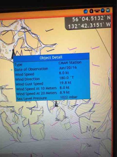
Regarding the problems with coverage in Alaska I can pull that data up right now on my system. See the attached photo. ImageUploadedByTrawler Forum1466433205.446840.jpg


Sent from my iPhone using Trawler Forum
 
Cafesport,

I like that nationwide view from your Furuno. Garmin doesn't display anything like that. As an example of the errors I see, at buoy 46084 off shore from Sitka, my Garmin shows winds of 10 knots with a forecast of 20 knots and seas to 8 feet. The sea state forecast on the Garmin is 3.3 feet. The buoy itself is recording winds of 19.4 knots and wave height of 6.6 feet.

Does your Furuno show data for:

Lincoln Rock: Station owned and maintained by NWS Alaska Region
Weather Station
56.058 N 132.690 W (56°3'30" N 132°41'23" W)

Site elevation: 6.5 m above mean sea level
Air temp height: 6.5 m above site elevation
Anemometer height: 7.5 m above site elevation
Barometer elevation: 6.5 m above mean sea level

Tom
 
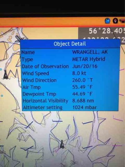
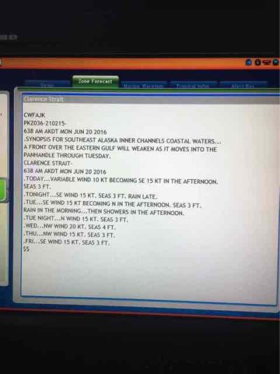
Here's some screen shots from my display of that areas current weather. First one is that Cman buoy next is a nearby airport and the last is the current noaa zone forecast.ImageUploadedByTrawler Forum1466452190.976061.jpgImageUploadedByTrawler Forum1466452206.250100.jpgImageUploadedByTrawler Forum1466452220.924016.jpg
Looks the differences in everyone's Sirius experience are perhaps more plotter dependent.


Sent from my iPhone using Trawler Forum
 
I agree, it is plotter dependent. So far I am impressed with the Furuno data.

Tom
 

Latest posts

Back
Top Bottom