Track Up or North Up?

The friendliest place on the web for anyone who enjoys boating.
If you have answers, please help by responding to the unanswered posts.
Keith, exactly the reason why one should go course up on the plotter. Navigation is a form of collision avoidance....in fact, it's primary purpose is collision avoidance. Anyway, not trying to change anyone's mind. I am just surprised at how many North uppers there are.
 
Peter B wrote:

Coming in bit late, but for what it's worth, I use course or heading up, but quite happily refer to charts north up. That is because mentally the GPS is sort of like looking at what is out front of me like through the windscreen, but in relation to surrounding landmarks, and tells you where you are going NOW. Whereas when looking at the chart I am an eye in the sky, as it were, looking down on the boat, and taking in where we have come from, where we are heading, and where we are in relation to far off objects. In our main sailing area, we have many channels where it is almost like driving along with marker buoys like road signs, so course up just makes most sense. Way out in the ocean might be different, but if I had radar, even then I think I would go course up, but marking position and progress on a chart nearby as well.

That's how we handle it... course up on gps and radar and north up on paper charts
 
Baker wrote:I am just surprised at how many North uppers there are.
Me too! Scary!

*
 
SeaHorse II wrote:

*
Baker wrote:I am just surprised at how many North uppers there are.
Me too! Scary!Bone chilling actually!!!

*
 
i agree with a few of the pilots in this thread.

course up is my preference while enroute flying/driving/boating, however a moving map/chartplotter showing north up is equivalent important to me.
and i think many MFD's can show both or toggle between the two modes.
i think many of the newer plotters have both gps and radar on one screen, so i would think then it would be beneficial to have everything course up.
incidentally a gps cannot show which way you are steering, only the direction you are moving.
 
Per....to put it quite succinctly, a GPS based plotter can only show your course....and NOT heading....unless there is a heading input into the plotter.
 
Carey wrote:


SeaHorse II wrote:

*
Baker wrote:I am just surprised at how many North uppers there are.
Me too! Scary!Bone chilling actually!!!

*

Still stuck on reading paper maps is my guess.* When you turn a map around the writing gets a bit hard to read when it is upside down.* Not so on the Chart plotter.

Course*up is the only way.*
 
Baker wrote:

Per....to put it quite succinctly, a GPS based plotter can only show your course....and NOT heading....unless there is a heading input into the plotter.

i dont have a plotter but could they be couples with a mag compass or would you have to dial in manually?

i still prefer to fly the old steam instruments in airplanes but i am guessing some of the newer fms displays the heading directly coupled from some sort of compass or gyro.
 
Baker wrote:

Per....to put it quite succinctly, a GPS based plotter can only show your course....and NOT heading....unless there is a heading input into the plotter.
_____________________________________________________________________________________________

John,
When my Lowrance is set course up, then as long as one is not swerving violently too often, the so-called track which it can display as an overlay, is the moment by moment (selected magnetic by me, but can display true), course, or heading, for that period of time.
 
Peter, unless your plotter has some way to input heading, it does not display heading. There is no sensor for it. I realize there are times that course=heading. But that is totally arbitrary. And I also realize we are splitting hairs. But in theory, unless your plotter has a "heading sensor" or an input from a heading sensor, it cannot display heading. Since you make a distinction between True course and magnetic course....we could get into that discussion although I don't think it would apply here.


Per, I would imagine there are digital compasses or heading sensors(same ones used for autopilots) that can send digitized heading information to a plotter. I guess radars use that data as well to figure out EBL and all that stuff. And much like the Nav systems on airplanes, if you have course data and groundspeed data and heading data, the by product of those would be our ability to compute the strength and direction of the current. I do not know if there is that feature in plotters but I would imagine there are.

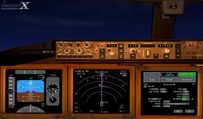
PS...Per, the PFD/MFD displays we use in airplanes have many modes but the default mode of the MFD is Course up. On your PFD you have all of the flight information(6 pack) on one screen with a little "sliver" of a compass at the bottom which will display your magnetic heading.

-- Edited by Baker on Thursday 3rd of March 2011 08:18:50 AM
 

Attachments

  • pfd1.jpg
    pfd1.jpg
    87.7 KB · Views: 68
Baker wrote:


PS...Per, the PFD/MFD displays we use in airplanes have many modes but the default mode of the MFD is Course up. On your PFD you have all of the flight information(6 pack) on one screen with a little "sliver" of a compass at the bottom which will display your magnetic heading.

-- Edited by Baker on Thursday 3rd of March 2011 08:18:50 AM
thanks for the photo, i see the mag compass in the lower left.
makes sense to have course up, but i am really surprise there is no heading indicator more visible. all through primary flight training heading indicator is a main instrument. perhaps have to do with the big role of a/p and fms; meaning you just dial in the course you want to fly, could really care less what heading produce this course, i imagine the system figures out the crosswind factor and flys that course instead of constantly making adjustments?

*
 
It does fly the "Course" and not just a heading...just like your autopilot would do if you had one hooked up to your plotter. A "course" is a line across the earth. The autopilot will follow that line ... in a boat or plane.
And as far as the heading indicator goes....it ultimately is just a case/issue of situational awareness. But you are also right....the dependence on flight control systems. I am not sure how often I look at that little sliver of the heading indicator.....not often or My mind sees it and processes the information subconsciously....I don't know. But if I am hand flying and turning to a heading, I will fly the flight director and roll out on the heading with the flight director cross checked with the heading pointer on the MFD. That is probably not the theoretically correct way to do it....it is just the way my flying brain has evolved. If the flight director was not in use(which is never), I would still do it the same except use the attitude indicator for roll information and then rollout on the heading bug on the MFD....and I would likely be checking the heading indicator as well as I would be "struggling" for extra cross check data. Please realize these displays are "changeable" and if you want a full compass rose, you can certainly have it. The purpose of having these displays is to INCREASE situational awareness....not decrease it. When you "waste" an entire display on a compass rose, you are decreasing it!!!
 
Baker wrote:

It does fly the "Course" and not just a heading...just like your autopilot would do if you had one hooked up to your plotter. A "course" is a line across the earth. The autopilot will follow that line ... in a boat or plane.
And as far as the heading indicator goes....it ultimately is just a case/issue of situational awareness. But you are also right....the dependence on flight control systems. I am not sure how often I look at that little sliver of the heading indicator.....not often or My mind sees it and processes the information subconsciously....I don't know. But if I am hand flying and turning to a heading, I will fly the flight director and roll out on the heading with the flight director cross checked with the heading pointer on the MFD. That is probably not the theoretically correct way to do it....it is just the way my flying brain has evolved. If the flight director was not in use(which is never), I would still do it the same except use the attitude indicator for roll information and then rollout on the heading bug on the MFD....and I would likely be checking the heading indicator as well as I would be "struggling" for extra cross check data. Please realize these displays are "changeable" and if you want a full compass rose, you can certainly have it. The purpose of having these displays is to INCREASE situational awareness....not decrease it. When you "waste" an entire display on a compass rose, you are decreasing it!!!
i hold several pilot licensees (commercial asmel+i and cfii/mei) but i havent been overly exposed to the newer displays but certainly can agree the advantage to improve situational awareness in airplanes and boats alike.

*
 

Latest posts

Back
Top Bottom