Sextant learning curve

The friendliest place on the web for anyone who enjoys boating.
If you have answers, please help by responding to the unanswered posts.

No Mast

Guru
Joined
Dec 12, 2014
Messages
816
Location
US
Vessel Name
Moana Huaka'i
Vessel Make
Selene 53
The thread on the US navy going back to teaching celestial navigation got me wondering. Does anyone here know how to navigate with a sextant? What's the learning curve like? is it easy to learn and get a decently accurate fix? What's involved?
 
Taking the noon sight is very easy and a way to learn the procedure. I don't know if anyone sells the inexpensive Davis plastic sextant, they are accurate enough for you to get an understanding of the system. eBay has lots of sextant since GPS came of age, top dog Weem and Plath sextants can be had for several hundreds of dollars instead of thousands.
 
Last edited:
...Does anyone here know how to navigate with a sextant? What's the learning curve like? is it easy to learn and get a decently accurate fix? What's involved?

No Mast
It isn't all that complicated...just a bunch of calculations.
I took one of the US Power Squadron courses and would recommend it for anyone interested (they offer 2 - basically beginners & advanced).
Most squadron instructors are pretty knowledgeable and patient w/ newbee's and they provide the sextants to practice.

There are forms & tables that you have to get familiar with and it's plug & calculate from there. It can even be considered fun by some...at least interesting by most.

If done correctly you can get an accurate fix - but it is meant for open water navigation (not coastal) so accurate means w/in about 1nm...
 
Well, it isn't a trivial exercise to take a sight, reduce it (look the data up in tables), plot it and find your position. Here are the basics:

Davis makes or used to make two plastic sextants. One was only good for rough sights, but another was pretty decent. A Japanese company makes a good one and you can find used Navy sextants on eBay.

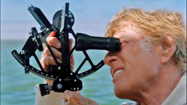
You then aim the sextant at the celestial object and simultaneously aim at the horizon (through a split mirror). You align the two things precisely and then note the time (to a few seconds) when they line up. This gives you the angle of elevation of the object at a specific time. You can use the sun, the moon, stars and planets. You need to take observations with a minimum of two objects, preferably 3 or 4.

Then you use tables published specifically for this purpose to take the raw elevation data and convert it to a line of position for that object. A LOP is line on the globe, theoretically thousands of miles long, where the data says that you were located when the sighting was made. You need to plot these on a chart for at least two LOPs to get an intersection to give you a fix. More than two sightings lets you plot 3 or more LOPs and the included triangle (or quadrangle, etc) of intersection tells you how accurate your sightings are.

First time navigators will be lucky to plot LOPs that are within ten miles of your real position, and sometimes a thousand miles away- probably due to a reducing error. But with practice you should be able to get it down to within a few miles.

On a bouncing boat, you will probably be back to a ten mile error range.

Here are some shortcuts:

You can use a saucer of water to form an artificial horizon. In this case you align the real and reflected images of the object and halve the measured angle. This can be just about as accurate as a clear horizon for practice purposes. You can also use an app on your tablet to reduce the sights, but of course that means you are dependent on that device working when you need it, so you might as well use the included GPS.

Good luck.

David
 
Last edited:
The best place to start would just be a basic class in celestial movements, especially the sun.

A sextant is just an instrument to measure angle of elevation of those celestial objects, but unless you use it every day, it's a waste of time.

It is helpful to know what the sun tells you local noon and with your watch, you can actually figure out latitude and longitude from that alone.
 
You use a sextant which you aim at the celestial object and simultaneously aim at the horizon (through a split mirror). You align the two things precisely and then note the time (to a few seconds) when they line up.

This part I'm curious how easy to do on boats our size w/ 3-5 ft seas.
 
Taking the noon sight is very easy and a way to learn the procedure. I don't know if anyone sells the inexpensive Davis plastic sextant, they are accurate enough for you to get an understanding of the system.

Simple and therefore a great backup:thumb:
 
This part I'm curious how easy to do on boats our size w/ 3-5 ft seas.

With practice you could probably fix your position within ten miles of reality. A small boat with 3-5' seas takes lots of practice to get a decent fix. And you might even lose your lunch while trying.

David
 
I would think a better skill to work with in coastal waters would be to use the dead reckoning mode in a navigation program or on an MFD and then with a hand compass, radar, and depth finder to place your boat in a position and then see where that is in relation what the GPS says.
 
I would think a better skill to work with in coastal waters would be to use the dead reckoning mode in a navigation program or on an MFD and then with a hand compass, radar, and depth finder to place your boat in a position and then see where that is in relation what the GPS says.

I tend to agree. There are loads of useful ways to navigate using visual bearings and radar when in coastal waters. A hand compass or some sort of pelorus, and you can learn to do running fixes fairly easily. Navigate using towers and stacks and lighthouses!

I never enjoyed celestial navigation, personally. I always expected it to be more about reading the constellations and stuff. I thought I'd be able to look at the sky and know where I was... It's a lot more work than that. Lots of number crunching and reading tiny numbers out of musty old books, all of which is like nails on a chalkboard to me. Reading the sextant is the easy part of the process.

If nothing else, It gave me a huge amount of respect for old timey sailors. People like Shackleton and Bligh. To sail hundreds and hundreds of miles in open boats, in the open ocean, navigating only by the stars. Truly a magnificent accomplishment.
 
There's an app for that now.....

(Sight reductions)
 
The Davis Mark3 is less than $100 on Starpath. You cannot think of your position like you do with the GPS, if you are within a 2 miles, you are on target. Reading the travels of Shackleton gives you a huge appreciation on navigation by the stars. The older navigation computers were actually easier to use than the current applications but they all get the job done.
 
The interesting thing to remember with this topic is that in order to accomplish this you need old fashioned paper charts to go along with it.
 
I would think a better skill to work with in coastal waters would be to use the dead reckoning mode in a navigation program or on an MFD and then with a hand compass, radar, and depth finder to place your boat in a position and then see where that is in relation what the GPS says.

I also agree. When I was a kid I would fix our position with the compass, depth sounder, and the paper chart. Very often this was done at night, in poor weather, trying to sail with no wind and an outboard that had quit once again. Dead reckoning was a bit tough since the speedo only worked half the time and the tidal currents are pretty high. It did give me a lot of confidence in navigating in the Salish Sea. One of the reasons that I keep a full set of paper charts on board despite my modern plotter.

I also thought the geek in me would enjoy celestial navigation. I always thought that it would be a waste of time for me as most of the time I can't see the celestial bodies let alone a clear horizon line.
 
UNDERSTANDING the trig is fairly complex .

Simply using the tables for a sun shot or for GASP Pre Selected Stars with a form to fill in.with HO MO TO is a snap.

The hard part is physical , the accurate units like a Plath get pretty heavy so shakey as you wait got local noon with a poor DR plot.

Use the UL or LL of the moon or some planets to tell the time , and you can brag like Slocum you have no timepiece.

Its great to have a backup if you go offshore as GPS can be easily knocked out.

Other non modern navs work great , Contour Nav with a recording depth sounder or a radio line of position are also easy to master.

Read Bowdich if you have the time,
 
Last edited:
I would think a better skill to work with in coastal waters would be to use the dead reckoning mode in a navigation program or on an MFD and then with a hand compass, radar, and depth finder to place your boat in a position and then see where that is in relation what the GPS says.

If anyone is thinking about celestial navigation for coastal you are using the wrong tool in the mariners toolbox.
Dead reckoning for coastal...celestial for open water.

There are many reasons for learning something...

Most folks that try \ learn celestial do it to satisfy a curiosity and prove to themselves they can do it... few ever get the chance to use it for actual navigation...even as a back up.
Some of us...especially retirees...have the time and enjoy continued learning even some things that aren't immediately useful.
 
While in the CG on an 82' patrol boat, our main navigation along the coast was triangulating radar fixes from known objects along shore, when entering or leaving unfamiliar harbors we triangulated using a pelorus on the bridge wing on the high endurance cutter. We also had Loran A for open ocean. Radio direction finding was a last resort. I've always enjoyed the triangulation methods, but, just like the OP I want to learn celestial, just cuz.
 
Sextants can be useful DR tools for shooting plot angles similar to a hand bearing compass.


Till GPS, many a USCG aid to Navigation was set using a sextant.


So if you buy one for the fun of learning, you can use it for inshore and offshore....even more to learn! :D
 
Last edited:
Dead reckoning for coastal...celestial for open water.

Not exactly. Dead Reckoning (DR) is using time, speed and distance to estimate where you should be on your track and is used for inland, coastal or blue water navigation.

Piloting is navigation using land marks, namely inland and coastal within sight of land, to determine a position (fix) that you then compare to your DR.

Celestial navigation is using sun, planets and stars to determine a position (fix) that you then compare to your DR. Generally for blue water since you need to be able to see a horizon to take sites that you then reduce to determine a fix.

Is it simple? Yes. Is it easy? Not really but it can become so with lots of practice.

Marty..........................
 
Not exactly. Dead Reckoning (DR) is using time, speed and distance to estimate where you should be on your track and is used for inland, coastal or blue water navigation.
Marty..........................

Marty...
I agree - my mistake in use of terms...
Others suggest dead reckoning much more useful... but my point is difficult to use dead (or ded) reckoning offshore exclusively w/o using celestial or GPS to confirm a fix at least periodically and as you point out ded reckoning & piloting are used for coastal where you have visual landmarks or nav aids for fixes.
 
With all of this having been said, If you want to try and learn it, if for no other reason than 'just because,' you should totally go for it. It certainly can't hurt to gain a new skill.
 
With all of this having been said, If you want to try and learn it, if for no other reason than 'just because,' you should totally go for it. It certainly can't hurt to gain a new skill.


Yup, like many others, enjoy learning just for its own sake. I may learn how just to do it
 
Always wondered about the origin of the word "sextant". Simple research shows derivation is Latin, "sex" comes from the one 6th arc the instrument covers, ie 60 degrees out of 360 degrees. In the course of looking up derivation, I saw that usage,traced since the 1600s,plummeted in recent years, presumably reflecting the use of GPS.
 
Couldn't be all that difficult. Redford learned it in about 2 scenes in the movie. Of course, he ended up lost anyway.:popcorn:
 

Attachments

  • redford.jpg
    redford.jpg
    52.9 KB · Views: 169
"w/o using celestial or GPS to confirm a fix at least periodically"

EP are easy to create with just a simple AM radio .

Estimated Positions are not fixes , but offshore at 7K, ,,what me worry?
 
Sextant use is just routine calculations and can be taught in an afternoon.Obtaining sights require practice particularly at sea. Sun-run sights and moon are easy . Stars are only difficult if you are not aware of the stars in the sky , however most sights are pre- worked, Accuracy within a couple of miles is attainable with practice.
Recommended book is "Ocean Navigator" by Kenneth Wilkes. He also has a book "Exercises for the ocean Navigator"
 

Latest posts

Back
Top Bottom