Longest Straight Line Ocean Route Around Earth

The friendliest place on the web for anyone who enjoys boating.
If you have answers, please help by responding to the unanswered posts.

Steady Hand

Member
Joined
Nov 22, 2015
Messages
24
Location
USA
Vessel Make
Available as Crew on OPB 2017
Howdy folks!

I came across this interesting animated graphic today that shows the longest possible straight line ocean voyage on Earth that does not touch land at any point.

It is 22,000 miles or 35,400km. Remember, that is a straight line, without touching land at any point.

While it is a route that no one would likely sail simply because of prevailing winds. It is interesting to see the route and if you watch for a moment, the animated globe will turn. It may take a few seconds to load the Google earth animated graphic.

https://m.imgur.com/J1BO7xL

I hope you enjoy it.
 
interesting, but they pick arbitrary start and end points and it's not even a circumnavigation.

But I did plot it on CE and it shows 19,129 nm you need to put one way point in south Indian ocean so CE does not flip the route and go across North America,
THanks
 
hmm... gonna need more fuel
 
Maybe I'm missing something, but how do I sail from Seattle to Duluth along the Canadian border?
 
Maybe I'm missing something, but how do I sail from Seattle to Duluth along the Canadian border?

Put a larger prop in, add wings, and run it in reverse real fast. Oh, you may need to take the canvas down also.
 
Hmmm, where does the great circle thingy come into this??
 
Oscar, I was just pondering the same thing. I think this is projected in a way that the great circle curves seen on certain charts ("mercator projections"?) Don't appear in this "chart" or visualization of the route. If you drew this route out on a flat chart book, you'd see how it curves
 
well...is it a "straight line" or not is the question.


I would guess a great circle route wouldn't conform with the title....
 
Oscar, I was just pondering the same thing. I think this is projected in a way that the great circle curves seen on certain charts ("mercator projections"?) Don't appear in this "chart" or visualization of the route. If you drew this route out on a flat chart book, you'd see how it curves

OK, I'll buy that.

So you would be changing course constantly....

DUH, of course you would....
 
Hi.

I wrote the title, so I can take the blame for any error there. :D

However, as I see it, the "straight line" route is meaning that the boat does not deviate from a straight course. There is no "jogging around land" or zig zagging to avoid land.

The point of the illustration is simply to show if one were to head off in a "straight" course around the world, what would be the longest distance you could go without touching land while NOT changing your course (lock the helm so to speak).

____________

To answer another question:

Without looking it up online, this is my understanding of the "straight vs. curved 'great circle' line on a nautical chart versus a globe."

A great circle route is the shortest route or line on the surface of a globe or sphere, from one point to another.

When that same line is drawn on a flat projection chart, it appears curved because flat projections (2D) cannot depict curved space or three dimensional objects accurately.

So, traveling from San Francisco to Tokyo, one does not just head West on latitude 38 if one wants to go the shortest distance (4536 nm to Yokohama). When seen on a mercator projection chart (I have a very large one hanging on the wall over my computer), the route appears to be an arc, with the curved course taking the vessel far north of the latitude line that San Francisco and Tokyo (Yokohama) share. The most northern part apex of that route appears to be north of the latitude of Portland Oregon.

Take an orange. Cut it in half. The cut is straight across or through the sphere orange. But if you trace the cut on the outer surface of the orange (peel) you will be tracing an arc or possibly a full circle, even if the cut is "straight" through the sphere.

Hope that helps. :)

And I am sure someone else can give a more complete or better description, this is just off the top of my head. :)
 
...The point of the illustration is simply to show if one were to head off in a "straight" course around the world, what would be the longest distance you could go without touching land while NOT changing your course (lock the helm so to speak).

Oh, so that line shown along the Canadian border and zig-zagging through the Great Lakes is just kind of extra, the straight-line trip would actually end in what, like the east side of town in Everett, Washington? Rats, I had this flash of excitement that I'd be able to motor up the Missouri, take a right at Ft. Peck onto the Milk River, grab the TransCanada Canal where the Milk touches the Canadian border, then I'm home free to Bellingham and Juneau and beyond with no haulout, no shipping, no dismantling the flybridge, no pilot car. Rats.

When we were done with the Erie Canal we should have boated to Duluth/Superior and started digging again. Heck of a lock system over the Rockies though. Looks like my only option is still getting a crane to drop me on the downstream side of the dam, motor to St. Louis (at least it's with the current) and then pop out around N'Awlins.

Probably simpler to take the panama and Suez route; less zigzags.....lol!

Q: how would you steer a great circle route with just a magnetic compass ...?
 
Ending in Everett wouldn't be an option, as there would be many turns from Flattery in.

The strait line would mean that the helm wouldn't be touched from start to finish. What would change constantly is our imperfect way of representing that strait course on flat surfaces, like charts, chart plotters, etc. If you had a globe in your wheelhouse attached to your GPS you watch the course and see your location moving across it in a perfectly strait line.
 
No doubt "straight line" doesn't mean a constant magnetic course.
 
: "how would you steer a great circle route with just a magnetic compass ...?"

Plotting sheet , in Bowditch
 
The old fashion way we did it in the USCG was to plot it on a gnomonic projection chart to see what lattitude the course would cross each longitude line and transfer it to a Mercator projection chart to actually navigate off of.


On the gnomonic projection chart...a great circle course is a straight line. The transfer would then show up on the Mercator as a bunch of short straight lines forming a loosely shaped semi circle.


Not all that accurate unless you get very detailed...but in the days before GPS....way good enough.


Can't remember doing it on a plotting sheet...but guess it would be the same...just hard to fine tune at that scale I would also guess.


From Wikipedia....


The Mercator projection is used on the vast majority of nautical charts. Since the Mercator projection is conformal, that is, bearings in the chart are identical to the corresponding angles in nature, courses plotted on the chart may be used directly as the course-to-steer at the helm.
The gnomonic projection is used for charts intended for plotting of great circle routes. NOAA uses the polyconic projection for some of its charts of the Great Lakes, at both large and small scales.[4]
 
Last edited:
The old fashion way we did it in the USCG was to plot it on a gnomonic projection chart to see what lattitude the course would cross each longitude line and transfer it to a Mercator projection chart to actually navigate off of.


On the gnomonic projection chart...a great circle course is a straight line. The transfer would then show up on the Mercator as a bunch of short straight lines forming a loosely shaped semi circle.


Not all that accurate unless you get very detailed...but in the days before GPS....way good enough.


Can't remember doing it on a plotting sheet...but guess it would be the same...just hard to fine tune at that scale I would also guess.


From Wikipedia....


The Mercator projection is used on the vast majority of nautical charts. Since the Mercator projection is conformal, that is, bearings in the chart are identical to the corresponding angles in nature, courses plotted on the chart may be used directly as the course-to-steer at the helm.
The gnomonic projection is used for charts intended for plotting of great circle routes. NOAA uses the polyconic projection for some of its charts of the Great Lakes, at both large and small scales.[4]

Thanks, interesting read; I never knew radio waves follow the great circle route.

When I used to fly light a/c we had to track NDB's; a total nightmare in cross winds, and even more difficult to make an accurate 'let down' in cloudy conditions....

I suppose you could do that too on a boat if you could pick up a powerful enough radio station.
 
remember...the great circle route IS the shortest distance between 2 points on earth so most things that travel the shortest distance would.


also flew many a NDB approach....try it in a low, slow helo....only good news is lot's of options when you broke out...
 
remember...the great circle route IS the shortest distance between 2 points on earth so most things that travel the shortest distance would.

also flew many a NDB approach....try it in a low, slow helo....only good news is lot's of options when you broke out...

I think everyone said this already, but it is both a straight line and a great circle route.

That's why I checked it out using coastal Explorer, which makes great circle routes as I have it set up.
 
I think everyone said this already, but it is both a straight line and a great circle route.

That's why I checked it out using coastal Explorer, which makes great circle routes as I have it set up.


Hi Richard,

Did you compass start pointing in weird directions when you tracked northwards on your trans-Atlantic trip?
 
I am glad to see some interesting comments on this thread, and have enjoyed reading those posted by others. :)

My Pet Peeve: Mercator Projection wall maps mislead people into thinking continents are a certain size, because of the distortions caused by the projection.

I often point out this difference (distortion) to children when I see they have a globe, as I want them to see that the real relative size of the continents (shown on the globe) is much different than what is shown on a typical wall map in their room or in their books. The visible difference can be astonishing. :)

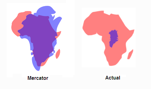
For example, Greenland looks HUGE on a Mercator map, but is much smaller on a globe.

Similarly, Africa looks big on a Mercator map, but not as large as it really is (on a globe).

Simply put, as one looks at the Mercator maps, the further from the equator (closer to poles) one gets, the more distortion there is shown, with the land masses being stretched (enlarged) as you get closer to the poles.
 
Clip from an article: "Created by Flemish cartographer Gerardus Mercator in 1569, the Mercator projection preserves direction, instead of size, making it useful for navigation."
_____________

I love geography, so when I see a chart or map, I am drawn to it. :)

Here are a few illustrations to show the relative size of Africa to other countries and to Greenland. These illustrations are based on actual surface area comparisons.

Notice that Africa is about twice as large as the former Soviet Union!

Notice that the Continental USA and Europe and China AND India could ALL fit inside of Africa! That is HUGE!

Notice that Greenland is actually MUCH smaller than Africa, only about 1/14th the size of Africa, now go look at a typical Mercator map where Greenland appears about the same size as Africa, because of Mercator distortion. The second illustration shows a blue Greenland overlaid on top of a pink Africa, in both Mercator and actual size.

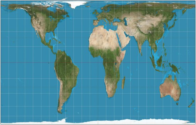
I am also including one projection that says it shows the true size of the land, so it may look a bit distorted or odd, as our minds are accustomed to the Mercator projection maps.
 

Attachments

  • Actual Size Map of Countries.jpg
    Actual Size Map of Countries.jpg
    113.5 KB · Views: 295
  • Africa size compared to Greenland.png
    Africa size compared to Greenland.png
    13.6 KB · Views: 311
  • africa compared to USA 4x.png
    africa compared to USA 4x.png
    177 KB · Views: 8,529
  • Africa Size Comparison.gif
    Africa Size Comparison.gif
    51.7 KB · Views: 315
  • Africa true size.jpg
    Africa true size.jpg
    69 KB · Views: 770
Last edited:
Wow, wow, wow !!!

My view of the world has changed dramatically ....!
 
Back
Top Bottom