Predict Wind?

The friendliest place on the web for anyone who enjoys boating.
If you have answers, please help by responding to the unanswered posts.

Seevee

Guru
Joined
Sep 1, 2016
Messages
3,501
Location
usa
Vessel Make
430 Mainship
How good is Predict Wind?


Are their predictive algorithms better than the other guys?


We really don't need current weather, we can read the stations, we need good forecasts... that's the hard job.


They are certainly quite pricey. Worth it?


And worth it for us intercostal guys, where crossing Tampa Bay is a big deal?
 
PredictWind is halfway through a 3-day 50% off sale. Here is a thread from yesterday with some commentary.

What I find cool about Predict Wind (and iNavX) is their passage planning functions that will also recommend a departure time (within about 4 days) for best weather or fastest passage. That comes with their $250/yr subscription. It's a cool feature if you're cruising. Not sure it has much value for day-trips. I find Windy is fine. I used to use BuoyWeather for quick forecasts, but got out of the habit when their free forecasts were too short.

If you're inland, I doubt it's worth the money, maybe the basic subscription which would be $15 with their discount. I really think PW's magic is with longer run passages. Doesn't sound like you're in that category right now.

Peter
 
I like Windy. It is pretty accurate around here.
 
Predict Wind has a free offering. There are limits of course to what you get.
When we went around to Barkley sound I anted up for a fancier package which was well worth the money. Gave us a lot more info.
Once we were back in home water I let the fancier package lapse.

As far as better than the others , maybe , maybe not.
They warned to look at at least two predictions for the area. If there are major discrepancies between them be very carefull.

I have used Windy but prefer Predict Wind.
 
I have had excellent results from Ventusky. A little known but very powerful app. Choose your models or let it run automatic (combined models). Much better on the iPad or iPhone then on a PC.

https://www.ventusky.com/
 
I have been using the free version of Predict Wind for several years and I think it's pretty accurate as far as weather apps go.
It's worked well for the 6 years I have been in Florida with the little boat.
 
Do any of these services pertain to the Great Lakes?

pete
 
Do any of these services pertain to the Great Lakes?

pete
They are all based on weather models that are for very large areas so would cover the Great Lakes. That said, I'm not sure they ate as accurate as you'd like for confined areas where micro events are influential. For example, I would be curious how they would determine wave height and frequency in the Great Lakes.

Peter
 
PredictWind and Windy both use weather models developed by weather agencies. The real question is which model is the most accurate not which App. Use the App that feels the most intuitive.

I find sailors tend to prefer PredictWind and pilots prefer Windy.

I find if all the weather models are predicting the same results then accuracy is very high. If the models are all predicting a different result then then obviously accuracy of any one model is low.

Which model is the most accurate? I hear that is region specific. Here in the PNW I haven’t been able to determine which model is most accurate. I have found that 90% of the time the accuracy is good.

I have not used beyond coastal cruising.

Note, both Apps have an option to select different weather models.
 
I believe Predict Wind runs their own weather model, as well as presenting many others. In particular their PWE and PWG models. These are their own model run with ECMWF and GFS initialization respectively. All of these weather models are run using a grid of cells, it is a finite element numeric type of computation, initialized by current observed conditions. Most of the models are using a fairly course grid and many don't include the effects of terrain, all to save computational time which is huge in these models. Big grids are OK in the open ocean where things don't change too fast, not so good inshore.

The big advantage of Predict Wind's models becomes apparent when there is terrain (they do consider terrain) and particularly where they run a 1km grid vs the 8km grid the others run. The areas served by this are limited because of the very high computational time, and you have to pay the subscription rate to get it ($29/yr is the normal rate). However the accuracy is very noticeably better, at least here in SF Bay and in the PNW where conditions can be very local and greatly influenced by terrain. You can check on the PW website coverage map for the areas served, 1km in small red squares.

In using any of these services, be sure to compare several different models. Often they will agree for today or the next couple, less often out 5 or more days. The agreement or disagreement you see in the models gives you a big clue about the reliability of the forecast: if everyone says it's going to blow in 5 days, it probably is!
 
Do any of these services pertain to the Great Lakes?

pete

Pete I have lived the past three years in Muskegon the East
coast of Lake Michigan and after thirty years in NH, Maine and coastal NC and this place is a friggin wind machine. Since August it’s been like twenty to thirty-five knots every day with fifty knots plus the past three weeks. Never lived anywhere that blows so much. Stick your head out the channel and you’re in trouble

Rick
 
We use Windy as a 1st go to - but also local weather service , NOAA, + any other source, including asking a long time local Add to that of our own 50+ years of sailing, it is not difficult to assess the situation and make a decision.
Re Lake Michigan- September this year was a bear
Took us a month from DeTour Harbor to Hammond.
 
We have friends who have subscribed to Weather Routing (WRI) out of New York. They ask for your constraints to predict weather windows. They are not cheap by any means. But seem to be very accurate. Another site they have that you can subscribe to is Sea Weather. From cruisers heading up and down the Baja the forecasts seem to be pretty accurate. Has anyone else used this service?
 
They are all based on weather models that are for very large areas so would cover the Great Lakes. That said, I'm not sure they ate as accurate as you'd like for confined areas where micro events are influential. For example, I would be curious how they would determine wave height and frequency in the Great Lakes.

Peter
Agree

Unless something has changed, I believe this to be true of most wind prediction programs that they are slightly tweaked algorithms that predict wind strength and direction form simple isobar data.

They are pretty good for wide area winds, especially areas of large expanses of flat water and flat land. The are generally inaccurate in areas where other local factors occur such as topography.

I will say that I often trust the NWS marine broadcasts more than most "freebee" wind predictors, adding that for winds under 15 knots...not so much but nearing 15 knots and more...pretty accurate.

It's a rare day that winds aren't 5 knots or higher over the water than land where friction from obstructions slows it down, diverts it and creates turbulence.

2 careers involving daily wind strength and my 2 goto wind predictors were the NWS and Passage Weather.

The big dollar passage advice people get is great for people who need it, otherwise it does take near a lifetime of experience to get a good feel for reading weather between the lines .(no pun intended about isobars :D).
 
Last edited:
The other important thing to remember is that all of these are computer models. I have seen forecasts that are very wrong such as forecasting 200mph winds in Cowes for a full day. This was obviously wrong, but a forecast that is only out by changing a true Force 4 to a F6 to 7 (or the reverse) may be believable but dangerous. As well as using Windy I always back them up with a weather forecast that has human input, in the UK this would be the Shipping Forecast or Inshore Forecast (https://www.metoffice.gov.uk/weather/specialist-forecasts/coast-and-sea)

I'm sure you have similar in the US

Gilbert Park
 
As I said above I use Windy a lot. Also I use the NOAA weather bouys. They are scattered across the Great Lakes, maybe elsewhere too. You send a text to the service with the buoy number and almost instantly it will respond with the height of the waves, wind speed and direction and water temp. So before we go out we can see the real time conditions.
 
We have friends who have subscribed to Weather Routing (WRI) out of New York. They ask for your constraints to predict weather windows. They are not cheap by any means. But seem to be very accurate. Another site they have that you can subscribe to is Sea Weather. From cruisers heading up and down the Baja the forecasts seem to be pretty accurate. Has anyone else used this service?
For longer range cruising, weather is second only to mechanical aptitude to comfortable and independent cruising. I've used weather routers a couple times when I delivered new boats that had nothing but VHF. I didn't care for it. They would tell me the "what" but not the "why."

Predict Winds $250/yr subscription is a lot of money, but it gives decent weather routing and departure planning, the best available. But I don't think it has value for many TF'ers simply because few TFers make multi-day runs. Once I eventually get going, I will purchase a subscription as a tool in my toolbox to augment NOAA synoptic charts and other sources. Even at $250 its a deal, but only if you're making multi-day runs.

Peter
 
The other important thing to remember is that all of these are computer models. I have seen forecasts that are very wrong

Forecasting is getting more and more accurate and reliable, but that doesn't mean margin of error is zero. Far from it. This is probably why I am not comfortable depending on a weather router alone. Sometimes, what youre seeing is vastly different than the forecast. Having an understanding of what's changed is important.

Back when I was delivering, the best weather products were synoptic charts via WeatherFax. On long runs, it was sort of an event to have the latest chart start scrolling. As I recall, there were about 8 forecasters in the NWS/NOAA office (Lee Chesneau being one). Each forecast was signed. After a while, you get to know each of their styles. Some were more detailed than others and would vary between them. Was also interesting to watch progression of 72hr forecast to 48hr to 24hr to current conditions. There was a fair amount of variance.

So while I have seen forecasts change a lot (Hurricane Ian being a very recent example), it's difficult to call them "wrong." If you don't pay attention to the progression or so not understand why the forecast is unstable, would definitely appear wrong, but more likely is just updated with better data. Symantics.

Peter
 
Last edited:
Predict Wind

Iam pretty skeptical about PW. I was sitting in Neah Bay and PW showed NW winds at 5-15. My mast head showed South 25, gusts to 40. Their recommended wind route would have been suicide on the coast! Had us passing inshore of sea stacks. Maybe it was just the Washington Coast but I was not impressed!
 
“2 careers involving daily wind strength and my 2 goto wind predictors were the NWS and Passage Weather.”

This has been my attitude as well. But in the setting that good low baud information was important.I’m indebted to Lee Chesnau for teaching me the little weather I know plus some reading. Nevertheless I believe gribs have major faults. Good for looking at a large wind field. Not so much for where you are at the moment. I don’t money for any GRIB commercial product beyond my annual donation to passage weather. All of them get their information for free. It annoys me to pay for something that’s free.
Rather I prefer the usual governmental services supplemented by either Chris Parker or Commander’s. For the same $250 you can get Chris for a year and the reports are individualized for your boat and your passage.
While doing the inter coastal we had TV and web. Often the local TV weatherman ended up the most accurate. For weather think it’s important to not base your planning on just one source. So it’s worthwhile to look at different models. Windy, PredictWind etc. is all the same stuff using the same information. I prefer arrows and vanes not colors for strength and direction. Old school but less likely to miss things. I prefer a 500mb and a synoptic to get the big picture and not just depend on gribs. Everyone is different so processes differently. The bride likes the colors. It’s good we both look at weather from different source presented differently. Only when we are both comfortable with our discussion do we plan.
 
Iam pretty skeptical about PW. I was sitting in Neah Bay and PW showed NW winds at 5-15. My mast head showed South 25, gusts to 40. Their recommended wind route would have been suicide on the coast! Had us passing inshore of sea stacks. Maybe it was just the Washington Coast but I was not impressed!

Micro-weather is difficult to alogorithmically forecast. Over the years, Santa Ana winds in Southern California have been reliably forecast, but it took effort and iteration to get it roughly right. Would not have been worth the effort if in a lessor populate area such as, say....Neah Bay. And it's not designed to route around obstructions. It's more of an offshore/nearshore prediction model. Less than that and there are other equally reliable products for free. In short, in my opinion, PredictWind is a powerful tool but for a fairly narrow use-case: multi-day runs.

I don’t money for any GRIB commercial product beyond my annual donation to passage weather. All of them get their information for free. It annoys me to pay for something that’s free.
Rather I prefer the usual governmental services supplemented by either Chris Parker or Commander’s. For the same $250 you can get Chris for a year and the reports are individualized for your boat and your passage.
While doing the inter coastal we had TV and web. Often the local TV weatherman ended up the most accurate. For weather think it’s important to not base your planning on just one source.

First, thanks for reminding me of PassageWeather. I had forgotten about that - is definitely one of my favorites because it is essentially WxFax that is more easily dragged down than NOAA.

Second, I totally agree about local forecasts when available.

For me, the use-case for Predict Wind that justifies the $250/yr subscription is for longer range passages. For short range ones such as Finnegus, there is no benefit.

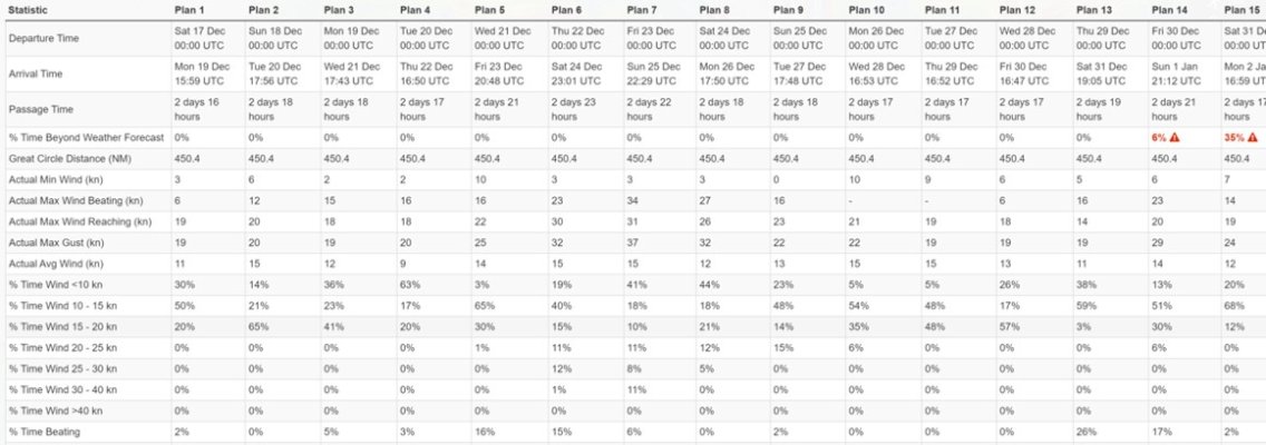
FastSeas has similar functionality as PredictWind, though with fewer models. They do offer 5 free departure/passage plans per month; and an annual subscription is $60. Because it's free, I did a quick one from St Pete to Cancun (Isla Mujeres). The route that leverages the Gulfstream is 4-12 hours shorter in duration at the expense of an additional 40 nms. There are tick-tock tables behind this (also attached, but likely illegible given small size - the PredictWind tables and routing are more intuitive, but again, only with the $250/yr subscription). It allows some granular decisionmaking.

Can you do this on your own using free weather products? Sort of, but only in large tranches of data; and you'd need some trigonometry to figure best angles for currents (BTW - if you want PredictWind's routing including ocean currents, it's $500/yr).

Peter

TPA to CUN FastSeas Dec 16 2022.jpg

FastSeas TickTockTable.jpg
 
Last edited:
Defer to you Peter as I have little experience with that product. For blue water I really appreciate a weather router I can get on the SSB, Satphone or via text/email. The thing I don’t quickly appreciate from the computer modeling as presented is the individual probabilities for things to work out as said. I tend to believe the European model more often but sometimes they’re off. So like having a live human being I can talk to. Especially with Chris who’s known me for years. Can you get that level of service from PredictWind?
 
In Australia, imho, the reliable boating weather predictor is www.seabreeze.com.au.
When Seabreeze and the Govt Bureau of Meteorology (BOM) conflict,it`s my experience Seabreeze is usually right. There are other weather services, paid and unpaid. The sailboat racing fraternity go to man is Ian Badham. The Sydney> Hobart bluewater race(starts December 26) competitors use him for predictions, both general and to best utilise specific characteristics of their boats.
More simply, we`re dining at an excellent authentic local Indian restaurant tonight. I predict wind.
 
Defer to you Peter as I have little experience with that product. For blue water I really appreciate a weather router I can get on the SSB, Satphone or via text/email. The thing I don’t quickly appreciate from the computer modeling as presented is the individual probabilities for things to work out as said. I tend to believe the European model more often but sometimes they’re off. So like having a live human being I can talk to. Especially with Chris who’s known me for years. Can you get that level of service from PredictWind?

First and foremost, whatever it takes to be comfortable with a passage plan is important. Could be a weather router, could be an online software gizmo, could be a Ouoija Board. Whatever it takes to be confident and independent.

Hippocampus has made some serious passages far outside easy SAR access. He and his wife/crew have made choices that were final, meaning they accepted the consequences of the outcome. That cannot be minimized or dismissed.

Its been many years since I've cruised, many years since I used a weather router. The fellow I used (Walt of Omni) was considered the best at the time. But he had many clients and frankly, the consequences of a bad decision were meaningless. He didn't know what I saw out the PH windows, I didn't know what he saw on his models. In the end, it was my decision based on information at the time which ultimately understood. He had the data, I had the situational awareness and responsibility. I was not comfortable with the dynamic, that's all I can say. Nothing wrong with a router, just a huge gap between what he sees on his charts in NJ and what I see out my windows in the Pacific.

Regardless of what tools someone chooses, the most important aspect is to develop a weather strategy that allows a level of confidence so you can make your own decisions. Whether a hired-gun router, PredictWind, NWS/NOAA, or some other mix of wx products, you need a weather strategy. Otherwise you will be subject to the fears of the lowest common denominator cruiser who can always find a reason not to leave anytime soon. For longer passages, I find PredictWind useful as part of a suite of weather tools. I do not find a weather router particularly useful.

Peter
 
Last edited:
Good post. They say in motorcycling “even in a group ride you ride your own ride”. Think it’s the same with marine weather. Think people commonly don’t understand even the basics of how weather is created and what that means to them boating. Yes I use a router on occasion and will in the future. However prior to my discussions with my router or before reading his instructions independently I’ve done my due diligence. Sometimes the router makes me aware of something I’ve not considered. Sometimes I’ll disagree and ride my own ride. But I have no hubris as concerns weather and accept those who have more training and knowledge than me are a resource.
Example. For one Salty Dawg I decided to leave 2 days before the rest of the rally. I thought two cold fronts would meet over the warm waters of the Gulf Stream and it would be a washing machine with strong squalls.. I wanted to be at least one day east of the stream before it’s occurrence. The rally leader (Bill) appealed for me to wait and Chris stated he thought the fleet would be fine. We left early. The fleet got severely beat up needing SARS and outside help. Several boats dismasted or knocked down with damage. We saw nothing over 20kts the whole passage.
Even with computer modeling weather remains a art and science. The butterfly flapping it’s wings in China still applies. I need all the help I can get. I’m no expert but know enough to take the most conservative outlook. Even in the above example my listening to Chris’s analysis helped make me think there’s no downside to leaving early but a real downside to leaving with the fleet. He was very helpful. So look at everything you can. Try to self educate so you understand what you’re looking at and it’s limitations. Don’t take any one source as gospel.

I was once declared overdue and then lost at sea when NOAA got it wrong. Both Commander’s and MXW have gotten it wrong with impacts on the Caribbean 1500 and the SDR respectively. Gribs tell half the story. Modeling frequently disagrees in the particulars. You need multiple sources and old school knowledge. We even find a recording barometer helpful as well as our eyes looking at clouds. Soak up everything. Then decide.
 
Last edited:
Hippocampus - I think the biggest differentiator is that you've "grown up" doing serious offshore passages. I have a lot of serious coastal passagemaking, but have almost always had bail-out options. While I have more 5-7 day nonstop runs than I can remember, they started with "looks like the next couple days are okay - let's see how far we can go....." My strategy relies solely on being coastal. I am not sure what tweaks I would make if I started crossing oceans. But relying on rolling 3-day wx windows would not cut it.

Communications have also gotten much better. It's one thing to use a router for departure planning where you have have an adult conversation. But until fairly recently, in-transit updates were cryptic email at best, which I preferred to voice calls (though I think it was you who said you used to record the call with Parker, which is a good idea).

But to wrap it up, you and I have wx strategies that work for the style of cruising we have done. They are more similar than different, but definitely different because the underlying use case is different. They are at the outer reaches of most TF cruises so may/may not be instructive. The #1 reason I joined TF and CF 4-5 years ago was to understand what had changed in accessing weather data and forecasting. I find these threads helpful.

Peter
 
Micro-weather is difficult to alogorithmically forecast. Over the years, Santa Ana winds in Southern California have been reliably forecast, but it took effort and iteration to get it roughly right. Would not have been worth the effort if in a lessor populate area such as, say....Neah Bay. And it's not designed to route around obstructions.

I don't disagree but it was not just Neah Bay. We were running from Neah Bay to Astoria 160 Nm down the coast and PW had the weather way off from NOAA and observed conditions for the entire coast. They were close for the Columbia River and south, but when we put in for weather routing from Neah Bay to the Columbia River the route down the entire coast was nuts. When I was looking at predictions and route planning I was more interested in 10 Nm miles off the coast or 40 Nm for most comfortable ride. I would think that if you are offering route planning on an app you would not route within 10 miles of the 160 miles of the Washington coast. I think most people who boat here would know better but.....
 
F good post. There’s two key determinants beyond a cold factual statement of weather that enter into the go/no go decision. What boat and who’s on it. I’ve benefited from weather routers knowing me and my boat which permits a individualized report. Still hold that personalized service is worth the $ c/w a pure computer generated report or prediction. Like “be at xxx coordinates by xxx time”. Or leave no later than xxx and no earlier than xxxx. Run between xxx and xxx knots.
 
Finnegus, your experience is highly instructive....but only if you go a bit deeper to understand why the forecast was either wrong or your interpretation of it was wrong. Here's a link to the Ocean Prediction Center for North Pacific. These types of charts are posted at every harbormaster office along the north coast (specifically, the 24-hr and 48-hr Surface Analysis charts; and often the 72-hr chart). I have no idea why PredictWind routed you the way it did - doing a comparison would be a good learning experience.

Circa 2002, I remember running off Costa Rica (Pacific Side). No WxFax or SSB just a Sat Phone/email, so used a router. I got a forecast to expect "3-6 from the west." I replied "I assume you mean 3-6 inches. It's a millpond out here." I would have loved to know what the router saw.

For highly tactical decisions (and I consider deciding between 10nms-40nms off coast over a 24-hour period to be tactical), decision is onboard. I suppose a weather router could speculate on land/sea interactions, but I doubt that over a 24-hr period they could add much, if anything, to the NOAA/OPC weather charts. I'd certainly consult PredictWind, but would not be my primary. The use-case for PredictWind is not tactical runs but multi-day runs.

BTW - I routinely ran this coast within 3-5nms during daylight hours; out to 600-feet depths during nights. I found that being close to shoreline beat-down about have the seas compared to running further out. There were exceptions - when passing Columbia River, would loop 10-15 nms west to avoid traffic, debris and currents.

Good discussion -

Peter

In our power boat with twins I often run very close, like you said it can really block the wind and swell. Crab season is another story.... We made the trip a number of times in our sail boat and then I always wanted to be at least ten Nm offshore as that is one unforgiving lee shore! There have been a lot of great comments in this thread and the one about the boat and who is running it being a factor is spot on. Our last trip 2 of three people aboard got sick in 20 knots of wind and we turned back because it was a boat that took 20 hours for the trip and I did not feel I could safely run the boat that lenght of time, then cross the bar dock etc... I guess bottom line as I am not doing crossings but just coastal runs. I look at apps, USCG Bar Conditions, real time bouy reports and NOAA. I don't think any one source is enough. That said our current boat can make the run at 16 knots so ten hours exposure Vs 20 plus is a huge difference in calculation. In a 5 or six knot boat I always wanted a 72 hour weather window to make the run. In our current boat I feel OK with a 24 hour window.
 
Last edited:

Latest posts

Back
Top Bottom