A Brief Journey Up The Sunshine Coast

The friendliest place on the web for anyone who enjoys boating.
If you have answers, please help by responding to the unanswered posts.

Juliet 15

Senior Member
Joined
Feb 27, 2019
Messages
291
Location
USA
Vessel Name
Knot Hours
Vessel Make
Hatteras 58 LRC
3 years ago we bought our dream boat with big plans to cruise Alaska, the west coasts of the America's, and eventually the south Pacific once I retired. I retired in Dec, and though our plans for this year were thwarted by family priorities (our last daughter's wedding and a family reunion) we salvaged 3 weeks in Septwmber and cruised up the inside passage as far as Desolation Sound. All told it was only about 420nm, far shy of what we'd thot we'd do if we'd been able to hit AK, but it was the longest trip on this boat, and our longest since 2003 when we sailed from Naples, FL to the Caribbean. For us it was a test run, a shakedown cruise, and an attempt to grab hold of a few weeks before the hazy days of winter set in. It was the most amazing and wonderful trip. As it ended my wife and I looked at each other and said we wished we could just turn around and keep going. FWIW, here's a narrative of our fun trip, with some pictures.
 
Day 1, 6 Sept. We're supposed to leave tomorrow, but the wind in the Strait of Georgia is forecast to hit 25 to 30 kts. We decided last night to go a day early. Deb has everything ready, and we plan for a 1000 departure to catch the tide push. Murphy strikes. That morning an acute but minor medical issue pops up, and we don't cast off till 1400. I'm still learning to let go after 40 years of work, and I did really well reminding myself that I'm retired - no schedule is worth fretting about. I resist the temptation to run at max rpm, and we settle down to 7.5 kts, grinning like kids to be underway. The down side - we don't arrive at the Vancouver customs dock till 1830, and sunset is 1930. Our anchorage is still 90 minutes away. Canadian customs clears us in a record 5 minutes and were on the way, but the light is slowly fading. I'm concerned about a night run to an unfamiliar anchorage and say we need to just bite the bullet and go back to the dock. My wife hands me a box claiming it's an early birthday present. It's a set of night vision tunes. Wow. She's amazing.

We cruise on flat water, enjoying the beautiful sunset, lighthouses, and mountains, finally arriving in Hacklett Bay on Gambier Island, Howe Sound in pitch black. We spend 20 minutes hunting for a good place to drop the hook, but neither of us is stressed. We just relaxed, focused, and worked together. We ended up touring most of the bay before going back to where we started. We anchored in about 53 feet and finally shut the engines down at about 2015 after we felt the reassuring tug of the set anchor. We're here! We made it! And we did it at night without stree or squabbling! We climbed up on the bridge deck and watched the stars, then went to bed. It was a night to remember.
 

Attachments

  • 20220906_161123.jpg
    20220906_161123.jpg
    160.8 KB · Views: 56
  • 20220906_161259.jpg
    20220906_161259.jpg
    113 KB · Views: 74
  • 20220906_170447.jpg
    20220906_170447.jpg
    160.4 KB · Views: 54
  • 20220906_195202.jpg
    20220906_195202.jpg
    182.6 KB · Views: 54
  • 20220906_194911.jpg
    20220906_194911.jpg
    79.2 KB · Views: 52
Last edited:
Greetings,
Mr./Ms. J. Good for you! Sounds perfect. " We climbed up on the bridge deck and watched the stars, then went to bed. It was a night to remember." Hmmmm....


200.gif
 
The next day was, as forecast, windy. We were 2 channels removed from the strait, and still the wind picked up enough to create 2-3 foot chop in the bay. It was a bouncy day, but sunny and beautiful. We couldn't kayak or go exploring, but we used the time to read, plan, and do upkeep stuff. Things mellowed out just before sunset, and we were able to eat dinner on the bridge and watch the seals and birds around us. The sun turned the sky gold as it slipped below the surrounding hills, and we passed a quiet and still night. Our anchor is a Rocna 55 (121 lbs); it never budged during all the wind and several tidal changes, so we slept great. Our plan was to leave around 8 to again try to catch the tidal push up the strait, and our hopes were high.20220722_133041 - Copy.jpg
Pic 1 is our steed. Pic 2 is just a shot of some of the cool homes on the water's edge north of Vancouver (English Bay, Brurard Inlet).
20220906_200630 - Copy.jpg
 
Day 3, Thu, 8 Sept: Pulled up the anchor and motored out of Hacklett Bay. Wind is calm, water is flat, and the sky is blue - it's a perfect day... Until we reach the Strait of Georgia. The Canadian meteorological peeps have the same malady that afflicts our US weather guessers. They forgot to tell the wind that it's time for blowing had expired. It took about 45 minutes to get to the strait, and it was beautiful and flat calm until we turned north into it. The waves were 4-6, and the wind was still up around 15-20 knots. We wanted to see how she did in a seaway so we motored on, slowing to 6 knots. We thought we'd done a pretty good job of securing before leaving, but after a couple hours and few things falling over (the table on the aft deck, a flower vase) we decided to wait things out a little longer. We turned around and pulled into Gibson, a small touristy town at the N edge of the sound, and anchored there. Lots of boats anchored there... Hmmm...


Interesting note: during the turnaround we spent around 10 minutes with solid beam seas. I assumed that would be the worst, as we'd be doing some serious rolling, but I was surprised and encouraged - there was virtually no roll. The old Naiad 251 stabilizers kept us level. The whole boat would climb the waves then slowly drop into the troughs without ever rolling. IOW, the beam seas were better than the head seas because of the stabilization system. I was impressed. This boat has a soft-chine displacement hull - very rolly in a beam sea, except for Naiad. Nice to know.


The bay was pretty deep, so we anchored in 75' of water and pulled out our charts, looked at weather forecasts again (Windy was calling for 1-2' and <10 knots!). I felt it was best to stay put there for a night - we could dinghy into town, play tourist (not really our usual modus), and eat out somewhere. I was mostly concerned that my wife enjoyed the trip and didn't start questioning our plans for now and for the years ahead. I wanted this to be a great memory and cement her conviction to follow thru on our cruising plans. To my surprise, she said lets just wait till the tide changes and try again. So we did... and it was great! The wave size hadn't diminished 2 hrs later when we got underway again, but the wind/tide interaction had resulted in a much shorter wave period, so the boat bumped thru the waves instead of having enough time to ride up and down each one. We went for 6 or 7 hours, during which time the wind slowly died and we found ourselves in flat calm, running with the tide. It was fantastic, and the scenery was awesome. We sailed from the bridge helm the entire afternoon, where the engines are inaudible, and the boat felt like an old Cadillac with bad shocks - smooth, slow, soft. We made it to the north end of Texada (Tex-AY-da) Island, to Sturts Bay. After 2 attempts to anchor in 70' without success (dragged on a solid rock bottom) we noticed a guy waving to us from the nearby marina dock. I tried 16, but no answer. I didn't think to go 66A, which is where he was. We pulled up close and he said not to try anchoring - the bottom is bad, there are cables around, and we could take the end-tie for the night. Awesome. The Admiral took a few minutes to set up fenders and lines while I hovered, then we backed into the slip like pro's. I'd like to say that's how I always do it, especially when there's a crowd like that night, but it ain't so. There was no wind, no current, and I got lucky. :angel:
Turns out the guy was the acting Wharfinger (a term for the guy running the wharf). He lives in sight of the bay, and saw us come in, so he came down to help us in. Total with electric and water and trash was $68 Canadian (around $55 US) for the night. What a deal! He was a friendly older gentleman who regaled us for an hour with the history of the island. It's a big mining location, and he showed us the old lime kiln (1800's) and told stories of the island's community. It was a great time and nice to be tied up for the night after the long run.

The next day we would finally make it to Desolation Sound! We'd been looking forward to this for a long time, and went to bed excited for the days ahead.
 

Attachments

  • High Tide.jpg
    High Tide.jpg
    95.2 KB · Views: 47
  • Low Tide.jpg
    Low Tide.jpg
    125.1 KB · Views: 45
  • The Admiral.jpg
    The Admiral.jpg
    154 KB · Views: 54
Good stuff! The 58 LRC has been a favorite of mine for years. How easy to handle as a couple?
 
Day 4, Friday, 9 Sept:
Today's the day - Desolation Sound or bust. We got up at 7 and had an amazing breakfast of eggs Benedict, bacon, coffee and cinnamon rolls. My wife is a gifted cook, and i benefit 3 times a day! At 0730 we started the untying process, started the engines, and then, as promised, Mr Wharfinger was there at 0800 to see us off. I started the engines, we cast off the lines, and... Riiiiiiiiiiiiiiiing!! The warning bell began its shrill alarm. I scanned the gauges and saw the #2 engine rpm falling thru 300 rpm on it's way to zero. Crap. The starboard engine had died, and we were 2 feet from the dock, lines loosed, and moving away. I left the port in fwd idle, silenced the alarm, ignored the curious look from the wharfinger and my wife's questions, squirted the bow thruster for about 5 seconds to port and got us away from the dock. I went to 1000 rpm on the port side and started using the rudder for steering to head us in a safe direction, then told my wife over the headset the right engine had failed (aviate, navigate, communicate). I kind of figured what was up. I'd changed fuel filters before leaving, and sometimes it's hard to get all the air out of the secondary fuel filter. I gave her the controls and ran down to the engine room, flipped on the fuel prime for the right engine, hit the starter, and she started right up. I left the prime pump on for a few minutes, then shut it off when the engines were warm. It was fine the rest of the day. Nothing like a little morning surprise to get one awake.


We cruised thru the Copeman Islands, a small provincial park that is a series of islands 100 yards off the east coast of the mainland (the so-called sunshine coast, since much of the rain is dumped to the west on Vancouver Island). It's a very pretty area, with lots of nice houses right on the waterfront.


Finally we passed Sarah Point, and we were there - the entrance to Desolation Sound. It was really cool to be somewhere we'd heard about, read about, and to have finally arrived. The day was cloudless, the water all around was flat, and the mountains were jutting up in every direction. It was the kind of view cameras can't portray; it was exhilarating.


We'd had an anchor chain twisting issue come up when retrieving the anchor after our first night, so we thought this would be a good time (we were in 1200' of water) to lower the anchor chain all the way out then pull it in to remove any remaining twist. I messaged some friends back home, who agreed that should work, but warned me the local Coast Guard might see me doing it and think I'm fishing for whales. :lol:
I began lowering the anchor and got to about 100' and stopped. Note to all those out there who haven't figured out what I was just figuring out: don't try this. The anchor is over 120 lbs. The chain is 1/2" chain. It's gotta weigh 3 or 4 pounds a foot. I was hanging almost 500 pounds of metal over my bow roller, and it was not happy. Click. I should be doing this in 50' of water where planet Earth can support my 300' of chain and anchor, not my poor bow roller and windlass. :banghead: I pulled it all back in and we moved on toward our first night's destination, Squirrel Cove (so named, I think, because there are NO squirrels there...). Squirrel Cove is pretty cool. You enter a moderately large square-ish bay, drive to one of the corners, the one that DOESN'T look like it's little channel goes all the way thru. The other corner has what appears to be a wide channel leading to an inner bay. Don't go there. Go thru the little one. It's tight, but deep. You pass thru it and enter an inner bay that's bigger than the outer bay, and mud bottom, uniformly around 20-40 feet deep. It's perfect. The mountains and hills are 360 degrees around it, it's beauty is stunning, and it has a little lagoon up in the NW corner.

We anchored with 4 or 5 other boats in the big northern portion next to a small island and lowered the dinghy and kayaks. We were here! After a fantastic lunch and some time just breathing it all in, we jumped in the kayaks and paddled over to the lagoon entrance. It was a small creek with a slight rapids, just deep enough for kayaks, except it was flowing into the cove, maybe 50-60 yards long, coming from what appeared to be a small "lake" on the other side. We portaged the kayaks along the sides, plopped them back in the water on the other side, and spent the next 2 hours exploring this breathtaking little lake. It was like we'd gone back in time. There were no people, lots of wildlife, and virtually total silence. We explored the lake from one end to the other, climbing out to walk the islands and beaches, and spent time just sitting and taking it all in. It was profoundly peaceful, beautiful, and we could have stayed there for hours, but the sun was getting close to the tops of the hills, so we headed back to the little rapids that should easily slide us back into Squirrel Cove. But it was not to be. Inexplicably, the small creek flowing OUT of the lake and INTO Squirrel Cover had undergone a metamorphosis. Gone was the pleasant tumbling outbound creek, and in it's place was a wide, roaring INBOUND rapids that you'd see on the cover of a whitewater rafting brochure. Wha....?
Ah, that's the difference between a lagoon and a lake. We'd assumed the "lake" was a freshwater body fed by streams from the mountains, flowing perpetually into the cove. It wasn't. It was, instead, a saltwater body that was filled up by high tide in the cove, and would then leak back out as the tide lowered. And it was now a very high tide in the cove, and the torrent flowing into the lagoon was pretty respectable. It took us 15 minutes of carefully picking our way along the edge of the river flowing the unnamed lagoon to drag our kayaks and our pride back out into the cove. A couple of the boats anchored there had people on the back decks watching us navigate our way out, and commented on how significant the tidal change was. The next morning there was a young couple "riding" the whitewater into the lagoon then returning to the uphill side to do it again for the thrill of it.
We got back to the boat, barbecued some steaks, and climbed up to the bridge to watch the sun set and the stars come out. It was a cloudless, moonless night, and one for the books.
 

Attachments

  • Entering Desolation Sound.jpg
    Entering Desolation Sound.jpg
    118 KB · Views: 35
  • 20220909_161741.jpg
    20220909_161741.jpg
    141 KB · Views: 33
  • The Quintessential DS Entry.jpg
    The Quintessential DS Entry.jpg
    82.1 KB · Views: 33
  • 20220909_162203.jpg
    20220909_162203.jpg
    198 KB · Views: 35
  • 20220909_172824.jpg
    20220909_172824.jpg
    159.5 KB · Views: 31
  • 20220909_174711.jpg
    20220909_174711.jpg
    196.2 KB · Views: 33
  • 20220909_165249.jpg
    20220909_165249.jpg
    184 KB · Views: 33
RTF: Just sayin'...! (Actually, not what I intended to convey :rolleyes:)
 
Good stuff! The 58 LRC has been a favorite of mine for years. How easy to handle as a couple?


It's a cream puff to handle. No problems for 2 people, IMHO. Some things to note: 500 gal of water and 2400 gal of fuel make for a heavy boat, so there's some inertia to appreciate and plan for. There are a lot of systems, so it helps to be pretty mechanically handy. But if you want to go a long way in good comfort and can't afford a Nordhavn (like Jeff!) it's a great boat. My understanding is they only built 40 of them, and the good ones are very hard to find. People tend to hold onto them. Mine cruised on her own bottom across to Europe, back to the Caribbean, thru the canal, up tot Seattle, then Canada, then I bought her. I owe a lot to her previous owners who all appear to have poured a lot of TLC and dollars into maintaining her. Feel free to call if you want to talk about them if you're considering one.


Neil
 
Day 5, Saturday, 10 Sept: It was such a privilege to wake up knowing that not only did I not have to work that day - no crises to manage, no personnel to deal with, no cat-herding to do - but instead I was surrounded by breathtaking beauty, saltwater, mountains, and with my life-mate next to me. Wow. We stand on the shoulders of previous generations, and benefit beyond measure from their sacrifices. Soli Deo Gloria.


We slept in till 0800 (unheard of!), made breakfast together, and then thought about what to do. We decided to go see Teakerne Arm and Refuge Cove, both places we'd read about and were "just the next cove over". Note to self: In Desolation Sound and elsewhere, distances are huge. We sped along for over 20 minutes to get to Teakerne arm (actually thought we were going to Refuge Cove, but one 6000' fjord looks the same as the next from a dinghy, and we'd forgotten the GPS chip on the boat). The arm is vast, surrounded on 3 sides by huge mountains. The water was mirror-like, everything was completely still, the only movement our wake. We spent a couple of hours slowly following the coastline in and out of the several bays in Teakerne. The cliff walls were vertical in many places, and we'd find ourselves in a couple hundred feet of water 20 feet from the shore. At the eastern end we rounded the corner of a tiny cove and were greeted by a large waterfall, maybe 50 or 80 feet high, pouring out of freshwater Cassel Lake above. The sides of the cove surrounded the falls, and on the north side of it was a series of natural steps. A family had tied their boat to the rocks at the foot of the ledges/steps, and had climbed up to an overlook and were jumping into the water 20 or so feet below.


After exhausting Teakerne Arm we headed fro Refuge Cove. Refuge Cove is several miles south, and is about as populated a place as we found. There's a Cafe, a fuel dock, and a small store/post office all connected by a rickety floating dock. The place appears to exist solely for the boating tourists who flood the place in the summer. Since it was September they were out of most things, but it was fun to wander around and look. We filled the dinghy (realizing now we would need more dinghy gas than we had thought) and planned to return to fill our spare gas can. The guy at the fuel dock, Bill, told us there were eighteen total families who lived here in the summer, who owned the land in refuge cove. One of them was the guy who ran the garbage barge - literally, a barge owned by a man named Dave who accepts people's garbage at $5 a bag, and stores it on his barge. I didn't ask what he does with it. Bill said after Sept 15th everyone closes up and they leave 2 people there during the winter. Everyone else goes home to Campbell River, the biggest community just on the southwestern corner of Desolation Sound.


As we headed back to the boat we came across a large log barely floating in the channel between the inner and outer bays of Squirrel cove, and dragged it to the shore so no one hit it. We creatively got it to beach itself but not without risk.


The next day we decided we would head to one of the most beautiful places in the sound - Prideaux Haven.
 

Attachments

  • 20220910_105930.jpg
    20220910_105930.jpg
    207.4 KB · Views: 25
  • 20220910_150848.jpg
    20220910_150848.jpg
    85 KB · Views: 25
  • 20220910_153349.jpg
    20220910_153349.jpg
    115.9 KB · Views: 23
  • 20220910_155612.jpg
    20220910_155612.jpg
    200.3 KB · Views: 23
  • 20220910_173532.jpg
    20220910_173532.jpg
    104.5 KB · Views: 27
Beautiful photos and narration - inspiring! And that's a wonderful LRC, too. Thanks, Neil.
 
Day 6, 11 Sept:
After a good night's sleep and breakfast on the bridge under an azure blue morning sky, we left Squirrel Cove and made the hour-ish run to what is arguably THE hallmark of Desolation Sound - Prideaux Haven. If you're not familiar with it you might want to look at it on Google Earth. It's a moderately large anchorage with good holding in 50 feet and less, protected on all sides by hills, mountains, and islands. There's only one way in for any trawler or sail boat; an S-turn from the north in between islets, shoals, and big rocks that's probably 50 yards wide at it's widest. Not tough, but definitely a place to pay attention. After you pass thru the S turn you're in a cove that has (on a clear day) possibly the most amazing views of anywhere. We were at the end of a long summer, so most of the snow caps had shrunk, but it seemed we could see mountains and blue sky everywhere we looked. This was our first time, so I can only vouch for what we saw. There were probably less than 10 other boats in Prideaux. I'm told there are easily over 100 at the height of summer. Most of the year it's profoundly silent, desolate; but apparently raucous crowds descend on the cove in July and August, with seaplanes making numerous trips in and out carrying boaters and their friends, relatives, and partyers.


I'm glad we weren't there for that. Our memories will be of a still, beautiful place. Instead of vying for space with the 10 or so boats already there, some of them rafted together, we passed thru the small gap on the east side of the haven into Melanie Cove. Melanie is almost as well known as a Deso Sound Mecca as Prideaux is, but we'd heard it was almost as pretty and usually quieter and less crowded. That held true, as there were only 5 other boats in there. Melanie is long and kinda narrow. 2 boats were anchored in the middle, and 3 were stern tied to the rock cliff on the north side.


You haven't lived until you've stern-tied with just you and the wife. :blush: We'd only attempted it once before, with another couple some months earlier in our home waters of the San Juan Islands. I understood the desired end-state but hadn't spent a lot of time mentally walking thru how to do it. Ok, I'd spent no time thinking it thru. The other couple and we spent almost 2 hours providing good wholesome entertainment for our fellow boaters as we fumbled around. Ultimately, tho we got ourselves tied to the shore, we abandoned the idea, pulled the rope in and found a place to anchor.


That was fresh in my mind as we were heading up to Desolation Sound, so the Admiral and I planned out a detailed way we thought would work for just the 2 of us. Basically, prep is everything. We had a big fat 1" cotton rope 130' long. I'd found a spool and rigged it up so it would hold the rope and act like a thread spool, letting rope out as needed off the stern. The idea is we put a kayak on the swim platform with a paddle, ready to go, with the bitter end of the 130' rope in it and the rest on the spool attached to the gunwhale of the cockpit, ready to spool out. We planned to pull in, drop the hook, set the hook, then she would hover while I jumped in the kayak, rope in my teeth, and paddle to shore to tie it to one of the convenient 6" links of the chain the Provincial Park Service had kindly hammered into the rock wall. What could go wrong? :ermm:


We picked our spot in Melanie Cove among the moored boats and decided we'd stern tie between a brand new giant speed boat-looking thing and a fancy sail boat. Setting the anchor went without a hitch, and we let out enough chain that we thought our 130' rope would surely span the gap between our stern and the shore. I hopped in the kayak and... Oh yeah, we were short. Maybe 30 feet or so. We spent the next 40 minutes alternately letting out more anchor chain and backing the boat to get me closer to the rock wall. Once I could finally reach out and grab the chain I slipped the end of the rope thru it and tied a big ol' know to hold us. Ta-da! We did it. Our neighbors didn't seem too impressed. It was then I looked around and saw everyone else had run the line from their boat, thru the chain on shore, and back to the boat. That way they'd just have to loose one end from their boat and pull the line in by hand without having to kayak out the chain. And they all had this nice, floating yellow poly line. Not big old hemp rope like me. Hmmm. Note to self: we need some nice yellow poly line - like 300' of it.


We spent another 20 minutes getting the boat even closer to the wall so we could run the 130' line (it sounded so long when we started) from boat to shore to boat. You can do the math. After using some of the line to tie to cleats and some used going over the swim platform and down thru the chocks, we had to be within about 50 feet of the shore to make it work. The learning curve was vertical.


After laughing at ourselves a bit more I changed out of my now wet clothes (the rope soaked up huge amounts of seawater and each time I re-positioned it it would drip all over me) and we had some lunch. We lowered the dinghy and went exploring. I brought along a fishing pole and a crab pot. We headed out of Melanie/Prideaux and hunted around for a while before we found a spot shallow enough to set the crab pot. Everywhere is deep there - really deep. Often we would be in 200+ feet of water 10 feet from the shore. The mountains are 6 to 8000 feet high, and they plunge steeply into the water, with bottom often 1500-2000' deep. We found a nice steep drop off so I thought I'd try doing some fishing. I do a lot of fishing; not much catching, though. But this place made me look like a pro. My wife was impressed. I caught 7 or 8 fish in less than an hour. I was as surprised as she was. We weren't sure what we could keep, and most of them were smallish rock fish and one lingcod. We put them all back since we didn't know if they were legal, but it was a lot of fun. The admiral even caught one!


Back to Melanie cove we went for the night, fishless and crab-less, but happy as clams to be there.
 

Attachments

  • 20220910_201347.jpg
    20220910_201347.jpg
    61.4 KB · Views: 27
  • 20220911_181426.jpg
    20220911_181426.jpg
    119.7 KB · Views: 25
  • 20220911_182001.jpg
    20220911_182001.jpg
    75.3 KB · Views: 25
Refresh my memory, does yours have the 4 cylinder or the 6 cylinder engines in it?
 
It sounds like you are really enjoying the Sunshine Coast! Yes, use floating poly braid for your stern tie. Besides the obvious advantage of not having to go to shore to retrieve it, you might find the knot out of reach if you leave at low tide!

I usually have no crew, so I just anchor out in the middle. Much easier!

Refuge Cove is a co-op village. It wasn’t set up for tourists, but it’s a great place to get water, fuel, and provisions! It’s much the same as it was when I first saw it in the 1960’s…
 
Wow, the Garbage Barge is charging the same rates he did 6 or 7 years ago. What a deal!
 
Day 7, 12 Sept: We got up early planning to do some fishing and crabbing, then move over to Tenedos Bay. Our neighboring boat had left with crab pots, so we thought there might be good crabbing around.


We jumped in the dinghy and zipped out of Melanie and Prideaux (going slowly so as to not tick off all the other boats), and then headed out to find some shallower areas that we could "soak" the pots in. Shallow is hard to find up there... We eventually located some outcroppings off a small island that were between 40 and 80 feet deep. We stuffed some cat food, chicken, and crushed mussels in the bait can and tossed our one pot over. You could literally watch it sink to around 40 or 50 feet. We marked the spot on our GPS and moved on to find a nice steep drop off to fish some.


I am NOT a skilled fisherman. Fishing - yes, catching - not so much. But the fish in this area just outside the Desolation Sound park limits was great! We weren't super comfortable we knew what the rules were for keeping fish, so we didn't keep any, but the fishing was awesome. As long as we were fishing at around 50-60 feet near a cliff or wall we'd get a bite within 5 minutes. I was pretty skeptical I'd catch anything, so I hadn't brought pliers, gloves, or even a tackle box. I just had my one rod and a spoon lure with a treble hook. I would toss it in, let it drop to 50-ish feet, then jig it slowly back in. The fish seemed like kittens - unable to resist something moving. It made for a great memory. The Admiral even tried her hand and caught one in a few minutes. After a couple hours we'd caught 9 fish, including a nice Lingcod (ugly fish, but good eating). If only I was that good every other time I went fishing...


We went back later to retrieve the crab pot. Nothing. Skunked. Bummer. We'd been hoping for a crab dinner. We brought the pot back to the boat, and our neighbor asked if we'd caught anything. When we said no, he said, "Yeah, the crabbing up here is generally not good." I guess it makes sense. When the sea bottom is routinely over 1000' people's 100' crab pots don't reach them if they're even there.


We upped anchor and headed to Tenedos Bay, a little west and south of Prideaux Haven. There was only one other boat there when we arrived, despite the gorgeous sunny day and flat calm conditions. Tenedos offers 3 different anchorage areas. We chose one close to a rock/shell beach that serves as the train head to Unwin Lanke, a freshwater inland lake that has reputedly warm, swimmable waters. We were going to stern tie, so we got our "rig" ready, prepared to use our hard-won lessons, but we couldn't get the anchor to grab. Maybe we're too cautious, but I like to have the hook hold us still against both engines in reverse at idle before I say we're hooked. We tried three times, but the best hold we got was 1 engine in reverse at idle. If we tried the 2nd engine it always dragged. After the 3rd attempt we moved to the cove on the north side and tried it there. Same story. Crap. Are we doing something wrong? In the midst of all the up and down, I went to pull the windlass switch to bring up the anchor and found myself holding the switch - no longer attached to the windlass. Hmm. That probably isn't good...


The windlass is a gravity-down, electric-up Plath model. The way it works is you pull down on a round knob on the aft underside of the windlass to turn the electric motor on to pull in chain. To shut the motor off you push the round knob up. I pulled down and nothing happened, except the knob came off in my hand. At first my brain raced thru the parts inventory with dread, knowing I don't have one of these on hand. Then I noticed the knob had a shaft sticking out of it, and the end of the shaft which had come out of the windlass was threaded. Hmmm... It looks like the knob just came unthreaded from a nut or nut plate inside the switch box.


Not wanting to waste the opportunity to appear to be Mr. Miracle Fix-it for the wife, I showed her the "broken" knob, explained the windlass wasn't working, and we could be in deep kimche (kim-chee, a rotten cabbage delicacy from Korea, known to stink). I got some tools, sat on the bow, and disassembled the switch box. As I thought, the knob shaft had simply backed out of a nut welded onto a cage that moved the rather large switch to complete the electrical connection. Thrilled, I screwed the knob shaft in tight, loctited it, and reassembled the box, forgetting of course the gasket that had to have the wires run through it FIRST. @#%&! Disassemble, feed the wires thru the gasket, reassemble, etc... I hate when I do that. But, once i had it together - ta-da! Look honey - I fixed the windlass! She was suitably impressed, probably swooning inside at the stellar judgment she'd shown in marrying this genius. Or not.


We finally moved to the side of the bay, got the anchor to bite well enough that I could leave 2 engines in idle for a few seconds without dragging. I left well enough alone and dutifully jumped in the kayak and carried the (felt like) 100 ton rope to a tree on the shore and tied us up. We were grateful for the steep dropoffs. We were probably 30 feet from shore in 55 feet of water at low tide.


We jumped in the kayaks and paddles over to the train head to Unwin Lake, beaching the kayaks well up on the shore. The trail went into the woods for about a half mile. We could hear and see a small creek and waterfall to the left about 1/2 way along and noted it to come check out on the way back. We passed some Brits who were coming from the lake who assured us the water was "lovely". The lake was beautiful. It was pretty big, with a giant mass of logs jammed up at the mouth of the outlet, a small creek that drained into Tenedos Bay. When I say a giant mass of logs, I mean hundreds upon hundreds of logs. You could have built a small log village with that many logs. I was half expecting Unwin to be a dirty, green, lily-pad covered pond, but it's really a magnificent small lake. The Brits we'd passed had mentioned that the initial trail takes you to the lake, but if you keep going a few more minutes there's a good rock outcropping to get into the water from, so we kept going and found it.


I'm not a big cold water guy. I like warm water. I dive, snorkel, swim, you name it. In warm water. My wife, on the other hand, is a fish. She loves swimming, and routinely swims in water I wouldn't consider. But to be a good sport, I started stripping down with her once we got to the outcropping. No one else was around, so what the heck. Fortunately, she was faster than i was. She got in about knee deep and I noticed she'd gotten reeeeeel quiet... I asked if she was ok; she said yes, but it's a bit colder than she expected. When she got to waste deep she must have changed her mind, cuz she practically ran back out. Whew. I didn't even have to get my toes wet.


On the way back to the kayaks we detoured off the path to find the small falls we'd heard on the way in. What we found was a small series of three falls one right after the other, in which the creek from the lake tumbled over shelves of rock, ultimately falling into a pool about 4 feet deep. It was like a natural hot tub without the "hot". We could imagine 8 or 10 people sitting on the rocks around the edge of the pool up to their necks in the water sipping wine. It felt very remote, deep in the forest, miles from anywhere.


When we got back to the beach we found our kayaks were almost adrift; the incoming tide was significant. We were glad we'd put them up higher than we thought necessary. The tidal swings around there are slightly larger than we're used to. 8-10 feet is normal in WA; tides were commonly 15-16 feet here. We took our time kayaking back to the boat, slowly making our way around the edges of the entire bay. It was fascinating. The different types and colors of the rock walls, the areas where trees came right up to the water's edge, the small deer, hawks, seals, starfish, etc... It was a highlight of the day, really. Kayaks can go in such shallow water, and with the clarity of it, we saw so much. On the way back we noticed a sailboat that had anchored in the spot we'd tried earlier, so I stopped by to say hi and see what they'd done differently. John and Julie live Quadra Island, one of the larger islands in Desolation Sound. They'd previously lived in Campbell River on Vancouver Island but moved to Quadra after retiring. They were very friendly and we agreed to have them over for coffee in the morning.


They cam by around 9 and we talked almost until noon. Our time together was encouraging. As couples, our worldviews, political and social viewpoints, couldn't have been more different. Yet our conversation was pleasant, not fractious or caustic. We talked politics, both American and Canadian (and Ukranian, and, and, and...). We listened when they were speaking and actually learned some things about how Canadians and others of a viewpoint different than ours see things politically. And they listened when we explained things from our perspective. I believe we may have tweaked their views slightly on some things, and I know they shaped our views on some of the things we discussed as well. Mostly, it was great to have a deep conversation with good people of a different persuasion without emotion or defensiveness. As they climbed into their dinghy, they offered that we should look them up on Quadra if we made our way there. I hope we do.


We upped our anchor and excitedly made our way out of Tenedos Bay and left Desolation sound for good as we headed south to Powell River, a small town on the east side of the Strait of Georgia, where we would hopefully get a slip and meet some friends flying in from Montana to spend the next week with us. They had flown into Vancouver Int'l and hopped a small plane into Powell River to accompany us up Jervis Inlet, Queen's Reach, into Princess Louisa Inlet, home of the famous Chatterbox Falls.


It was about 3 hours to Powell River. On the way we heard and saw what sounded like a release of steam, then the long black back, fin, and finally the tail of a humpback whale. Then two, then 4... They were 100 yards off the starboard side, appearing about every 20 seconds, heading south with us. Pretty cool to watch.


Powell River is a great little Marina, and we slid into the guest dock with ease, right at the mouth of the marina. It was the first time in 8 days we'd had shore power and water, and didn't have to anchor. Nice break. We go there at about 3pm, and learned from the marina about the ZungaBus, a public transportation system using sprinter vans. You download the app, then basically order your pickup right at the head of the dock to anywhere, all for $2.25 (Canadian). We hopped on the bus with Luke as our driver and he took is to the grocery store "Save On Foods". What a great store! That had everything, and it was very nice, neat, clean, orderly, very, very stocked... We were hungry (bad idea) and bought a ton of provisions (ice cream, cookies...). 30 minutes after we arrived Luke picked us up for the trip back to the boat to drop off our goods. 15 minutes later he was back to take us to the airport to meet our friends. 30 minutes after that he was back to take the now 4 of us from the airport to a restaurant (Coastal Cookery -outstanding!). He was off duty after that, so after dinner we walked from the restaurant back to the boat where we spent a comfortable night at the dock. In the morning we were to set out for Princess Louisa Inlet and the Malibu Rapids.
 

Attachments

  • 20220911_181426.jpg
    20220911_181426.jpg
    119.7 KB · Views: 22
  • 20220911_180323.jpg
    20220911_180323.jpg
    194.1 KB · Views: 21
  • 20220912_153029.jpg
    20220912_153029.jpg
    189 KB · Views: 21
  • 20220906_204024.jpg
    20220906_204024.jpg
    74.1 KB · Views: 19
  • 20220907_211322.jpg
    20220907_211322.jpg
    120.9 KB · Views: 21
  • 20220912_165620.jpg
    20220912_165620.jpg
    193.5 KB · Views: 23
  • 20220913_191754.jpg
    20220913_191754.jpg
    124.7 KB · Views: 21
  • 20220914_104623.jpg
    20220914_104623.jpg
    194.3 KB · Views: 35
The 4-71s are a nice engine. We looked at a 58LRC with them. I had never seen that engine and was kinda surprised how big it was.
 
Day 8 (I think). Should be the 14th of Sept. I think I lost a day somewhere.


We slept in since the tide was going to help us if we left around noon. We'd decided at the last minute to split the trip to Princess Louisa into 2 legs. Today we'd make it to Hotham Sound, see the falls there, and anchor near the Harmony Islands, or deep in, up at the head of the bay if the islands weren't a good fit.


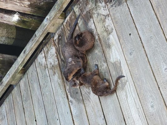
As we got set to go we were surprised to find a family of little "water weasels" (that's what they looked like), apparently known as sea otters, playing on the dock next to us. They were unafraid, playing, wrestling, and pooping wherever they felt like it. It was pretty cool to watch. The ladies were thrilled and took countless pictures. After a while I was like, look, I gotta go pay the marina and hit the chandlery, so sorry weasels, I'm coming thru. Not well received by the ladies, but time was passing. I had something to buy that we needed. You got it. A few hundred feet of nice floating poly line! :D


Jay and Lori were the friends we'd picked up the night before. He and I grabbed the dink gas can and headed out. The fuel dock wasn't open yet, so we dropped the can there and hoofed it to the chandlery. We got 200' of 1/2" poly line, and a bunch of caribeeners for an idea i had for making it easier to raise and lower the kayaks from the bridge deck. We stopped at the gas place and toted it all back to the boat where the little otter animals were still playing. It looked like momma and 3 cubbies. I had to admit they were cute. Except when they hissed at you for walking on their dock. Not so cute then.


We got under way on another amazing day with calm water, headed for Jervis Inlet. Of course, as we backed away from the dock it happened again. RIIIIIIIING! #%$@&! Stupid engine. The #2 engine failed again. By now we were good at it. (I forgot to mention in the last post that it happened leaving Prideaux and again leaving Tenedos). I kept the boat moving using one engine, rudder, and thruster while my awesome wife ran into the engine room to perform the ritual: right engine control breaker off, right prime pump on, restart #2 engine, right engine control breaker on, yell up "Ok, you're good", turn the right prime pump back off. If you haven't read the previous posts, we've been dealing with some air in the line of the right engine since I changed filters in WA. After about 5 minutes of idling the right engine takes a nap. As soon as you put the prime on it'll restart. Once it's restarted you can turn the prime pump off and the thing works for the rest of the day. So you forget about it. Till the next morning... This time I set an alarm in my phone to bleed the right engine tonight.


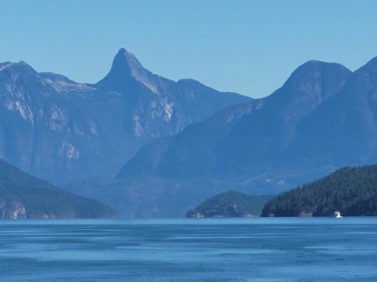
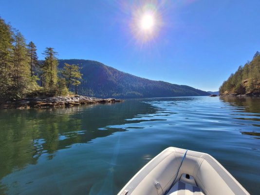
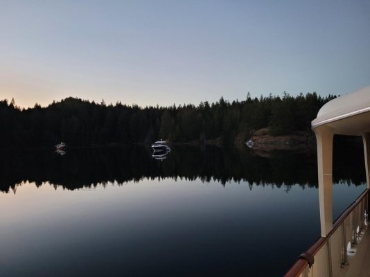
Jervis Inlet is a wierdly shaped fjord what juts out of the Strait of Georgia. It goes east-ish for a few miles, then does a series of 90 degree turns, first left, then right, then left again, all the way up to Princess Louisa Inlet. At some point it becomes "Queen's Reach" instead of Jervis inlet. Hotham Sound, where we intended to stay that night, is just before the first 90 degree jog to the left. The trip there took us probably 3 or 4 hours. There's a 1400 foot water fall at the southeast corner of the sound that is quite a sight in the spring and early summer. When we got there it was hard to pick out, and not much to see, since the lake above the cliff there hadn't seen rain for months. The Harmony Islands were enchanting, really a neat place, creating a beautiful and cozy anchorage between the islands and the mainland. On of the islands is private, and because the area is tight there's not much room. We found there were already several boats there, so we were squeezed out. We tried anchoring in a couple different spots, but it was in 80 feet of water, and the anchor dragged again on the rock bottoms, so as the sun got closer and closer to the hills we made for the anchorage at the head of the sound, about 5 miles in. I was concerned, as I don't like anchoring in new places at night, so as we raced the setting sun northbound I saw a small shallow section along the right side. Everywhere else was the usual steep cliffs plunging into deep water, but the chart showed a shelf here, and there appeared to be a seashell-covered beach. We turned in and to our delight found a great little spot. The water was 50' deep, shallowing slightly toward the shore. We got our stern-tie rig set up, the kayak prepped, and dropped the hook. It held the first time (yes!), so I hurried to the back, hopped into the 'yak, and paddled our new yellow poly line over to a tree at the shore's edge. Oh, this was SOOOOO much better than the friggin' rope. I looped it around a tree and was back in no time. We were probably 80' from the shore, and the sun was setting as we tied the last knot. Lori, who, like my wife, LIKES cold water, was suited up and asked if she could jump in. Soon she was swimming around in the 62 degree water. I have to admire her. I could not enjoy something like that. We had a great time laughing about it, then played some cards, talked into the night, and headed for bed. We had to leave at 0630 tomorrow. The entrance to Princess Louisa Inlet is a set of narrows called Malibu Rapids. The rapids should only be crossed by boats like this at or close to slack tide. To leave room for fudge we decided to leave at 0600. Sunrise was 0730.


Day 9: 0400. I ate something bad last night. My alarm was set for 0530, but at 4 I'm up with a stomach ache. To let my wife sleep I head to the helm with a book, planning to read till i fall asleep or 0530, whichever is first. For grins, I take a handheld spotlight and check the stern tie. Holy crap. When we went to bed we were 60-80 feet from the shore. From the helm looking back it looks like the swim platform is touching the seashell-covered shoreline. The tide has gone way out, and we are much, much closer to shore. I walk back to the cockpit silently thanking God for waking me. With the spotlight I can see we're actually about 10-15 feet from shore, and it drops off steeply from there. But it's still too close for comfort. I head froward and suck in some of the anchor chain. We had done accurate math on the tide and our depth on arrival, but I think the thing we didn't consider was how the extra slack in the chain as the tide fell would be taken up by the tightening of the line to the shore as our position dropped relative to where we'd tied up. The stern tie kept us close to shore as the water level dropped, pulling us rearward at the same time more of the beach became exposed. When stern tying to a steep dropoff, like Melanie Cove, you can be in close to the shore. Falling tides mean nothing when the water is still 50' deep at the shore. But when stern tying to a sloping shore we should have used the max line available to keep us away from the shore as the tide fell.


At 0530 I woke Deb and we shattered the deep silence and started the engines. We loosed the yellow poly line and rolled it onto the spool without a hitch, except that I was now having to make regular runs to the head. My stomach ache had matured... We hoisted the anchor between my urgent sprints to the head, and pointed the bow toward the mouth of Hotham Sound, Jervis Inlet, and Princess Louisa Inlet. At our speed of 7.5 kts we should arrive at Malibu Rapids 20 minutes before high slack tide.


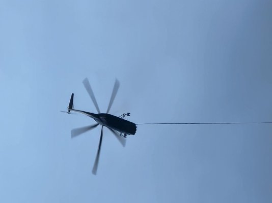
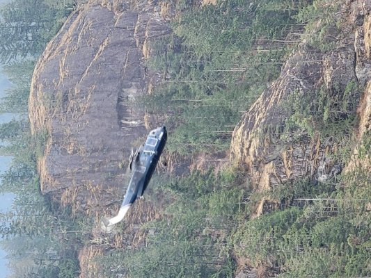
This was the first semi-cloudy morning, and the wispy clouds clung to the high mountainsides as the gray dawn slowly broke. It wasn't the cheerful blue we were used to, but it was magnificent and beautiful in a different way. The trip up Jervis was like following a mile-wide river that winds its way inland, except that we had a push from the incoming tide, enough so that we slowed back to avoid arriving too early. The many wild, jagged, and widely varying rock formations of the mountains on either side kept our interest along the way. We came across a series of boats that we recognized from the Harmony Islands the night before, and realized they'd been staging, like us, for the run to Princess Louisa. About 2/3s of the way up Jervis we came across a helo logging operation in progress. As a career helo driver I was fascinated to watch the crew. They were good at what they were doing. They used what's known as a long-line. They'd fly up the steep mountainside to an area near the top where there was dense forest. We'd often lose sight of them in the cloud bases. When we found them again they'd be hovering over the top of 100' tall trees with the line (presumably) hanging down between the trees being tied by a ground crew to a single big, long log. The log secured, the pilot would climb vertically until the log cleared the surrounding trees, then he'd nose over and, with the log held vertically by one end, swinging out widely behind and to one side, he'd dive down the side of the mountain. At maybe 200' above the water he'd flare, bringing the log under control and just in front of the helicopter. Then he'd lower the end of the log to the water, smack in the middle of this log boom (a raft of logs held in a bunch by cables). Then, in a very respectable display of incredible skill, he'd gently lower the upper end of the log, held by his cable, into the water. It was like he was putting a baby in it's crib - that's how softly he'd place the log in. We were very impressed. We got to watch him do 3 or 4 logs before we lost sight of him; things pass slowly at 8 knts. :)


The rest of the route was as unremarkable as it could be when you're surrounded on two sides by 6-7000' mountains and a salt water fjord under your keel. We arrived right on time at Malibu Rapids, and found several boats already heading out from Princess Louisa. The rapids have a blind turn, so people call on 1W on channel 16 stating their type and size, which way they're coming and offer a chance to deconflict traffic. We heard or saw 6 boats coming out by the time we arrived, and we were the first one in for the day, so we were expecting to find a good spot to anchor, moor at the dock, or on a mooring ball. We entered the rapids about 15 minutes early, and we could feel the movement of the water as it pushed us, but there was no problem at all. In a couple minutes we were thru. The view was surreal. I'll leave it to the pictures to describe. I can't do it justice.


On the northern point of the rapids is one of the most fantastic resorts you've ever seen. I'll share more about it in the next post. It's owned by YoungLife, a Christian youth ministry. We were given a tour of it while we were in Princess Louisa, and it's breathtaking. It's history goes back to the 1950's, and it's a pretty neat story.


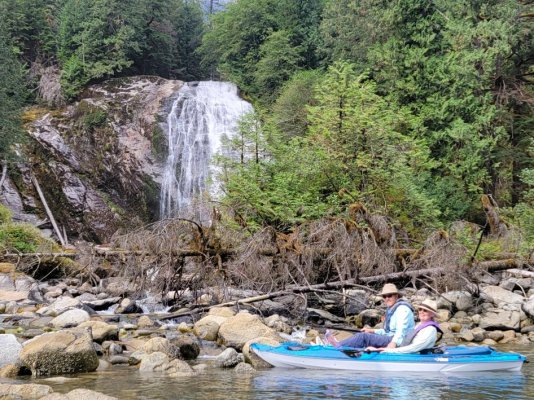
We were in a celebratory mood despite the gray overcast. We had arrived! This had, like Desolation Sound, been a dream destination for us for several years, and now we were here. Our eyes drank up every view and angle greedily. It's around 3 or 4 miles from the rapids to the end of the inlet, where the world-famous Chatterbox Falls roars day and night into Princess Louisa. Halfway there you pass a sign asking you to leave no wake, as it ricochets around the inlet. We passed McDonald Island on the port side, site of a small camp also owned by YoungLife, I think. There are trails on the mainland side there we'll hike tomorrow. Finally, the end of the inlet came into view. The clouds still clung to the tops of the mountains, but all around you could see little slivers of waterfalls, probably 7 or 8 of them, tumbling down in narrow sheets or like trails of gauze stretching from cliff to ledge to outcropping. And there, at the end of the inlet, was Chatterbox. It was late summer now, and though it was a substantial falls, it wasn't quite as loud and strong as we'd thought it might be. We didn't want to tie to the dock, so we debated anchoring, but ultimately chose to tie to one of the 5 mooring balls there. We were the only one on a ball, which was nice. THere were 2 boats anchored near the falls, and three at the dock. We moored to a ball right at the foot of a wispy little drizzle of a waterfall about 200 yards from Chatterbox, then my wife and our friends went to shore to see the falls and get the lay of the land. I needed to stay close to a head for a few more hours. :blush:
They weren't on shore 10 minutes when it finally began to rain. It started out as a drizzle, then a rain, and before long it was coming down like a Florida thunderstorm. They ducked under a small roofed pavillion for shelter, and after an hour or so it let up enough for them to dinghy back. They were full of pictures and excitement about the falls. It was pretty spectacular even though it wasn't at full flow. It rained the rest of the afternoon, evening, and night.


The next morning it was still raining, but forecast to break up and become sunny by noon. As we came up from our staterooms we became aware of a sound we couldn't place. What was that noise...? Looking outside we were stunned to see the trickle of a waterfall we'd moored next to had become a torrent, 30 feet wide with several rivers of water cascading off the rocks and into the inlet below. All around the inlet, what had been gauzy little wisps were all wide, rushing waterfalls, and where there had been NO falls now were new ones. It was startling. It looked like we were in a completely new anchorage. And there, louder and more attention-commanding than anything else in the inlet, was Chatterbox Falls. Overnight she had become a raging, roaring torrent, her highest visible waters at the top literally leaping out and over the falls. The crashing waters smashed into the rocks below with such force it looks like a power washer was spraying sideways. The wind created by the impact and speed of the flood pouring over the falls caused the trees next to the falls to sway like a gale was blowing. The rain had brought out, for time, the real Chatterbox, just in time for our visit.


The previous day, while my wife and friends were ashore, a float plane had landed and disgorged a bride in her white bridal dress and her groom in his black tux. Their photographer was with them, and they'd come to take wedding pictures by Chatterbox. Sadly, as they began to take the pictures, it had begun to rain, and before they could finish and get back to the plane, they were literally drenched, and carrying their shoes along what had been a dry trail, but was now just a muddy line in the grass. We felt badly for them, and wished they'd waited and come today instead - the rain was gone by 9, and the sun broke thru by noon, and Chatterbox was at her peak, showing off her might. It would have been a great time for pictures...


I was feeling better finally, so after breakfast we dinghied over to the foot of the falls to feel and hear its power. Then we tied up to the dock and walked the short trail to the side of the falls. You can get extremely close to the bottom of the falls, and it would be easy to climb up to the top. But there's a sobering sign there that implores people not to climb up the rocks. It says 12 people have lost their lives there ignoring the warning. Instead, we walked up as close to the side as possible. You can;t stay there very long, as it's pretty loud, and the spray will drench you in less than a minute. We got the obligatory pictures, then followed the trail down to the foot of the falls. There's a dam of logs and rocks that blocks you from seeing where the waters actually impact the rocks at the bottom, but you can see the river flowing out from around the dam, and the trees and leaves being blasted by the wind, the spray,and experience the falls that way. Bottom line, it was a great experience to see it, to be there when it was strong. All around were waterfalls, nothing like Chatterbox, but the overall effect was unreal. It was wild, untame-able, and vast, highlighting how small and fragile we are. Some thousands of feet up the mountains on the side of the falls were some ledges. On each ledge were 100+ foot tall trees, clinging to these narrow outcroppings. From our vantage point they appeared tiny - it wasn't until we looked at them thru binoculars we realized how large the trees are. The spaces are so vast, the objects that fill your vision so large that it's hard to grasp the immensity of what we were looking at. Big. Giant. Huge. Vast. Whatever descriptors you can use, they fail to convey. Pictures are an inadequate medium for sharing the experience. It was awesome.


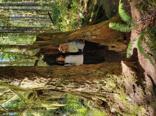
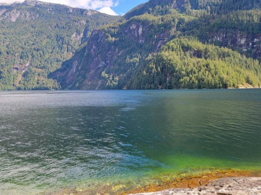
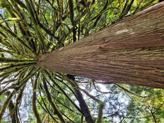
After a couple hours exploring the area we went back to the boat for lunch, then decided to walk the trails across from McDonald Island, 2 miles back down the inlet. We'd been told, "Don't come back till you've seen the bear." Um, ok... We left the dignhy at a small dock attached to a bald rock outcropping, surrounded on 3 sides by water. The trail leads deep into the forest where the trees are covered in spanish moss. Stumps are all that remain of what were once giants - trees that were 200 and 300 feet tall, old growth that was logged many decades ago. The trail is a loop that takes you to a rocky "beach" on the side of the inlet. There, our two wives climbed into the water and swam around. It was cold, and they both climbed out after a few minutes. We left the trail and walked back along the shoreline most of the way. It's a wonderfully scenic trail and shoreline, especially in the sun, as the water turns an emerald shade of green close in, and the sheer, 6,000 foot cliffs across the inlet are starkly visible. We found veins of quartz running thru the rock in many places. In 1927 a widow named Muriel Wylie Blanchet lived in the Pacific Northwest with her 5 children. She took her 25' power boat up into Desolation Sound, the Broughtons, and Princess Louisa every summer for 4 months at a time. In 1961 she wrote about their adventures back then in the '20s in a book called "The Curve of Time". We'd heard about the book, and ordered a copy so we could read it on the trip. It was fascinating to see and hear the contrasts and similarities today. Contrasts in the safety and knowledge and technology we bring, and the number of people and civilization that have filled in a lot of the area; similarities, in how the things she describes - the mountains, the falls, the waters, the wildlife, the wilderness - they're all the same. You can even follow the trail to the trappers cabin she talks about above Chatterbox falls. She's a skilled writer, and it's an amazing story to read if you ever come up here.


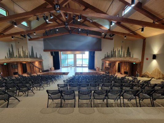
As we left The trailhead and dock by McDonald Island it was about 1530. On an impulse, I steered the dink toward Malibu Rapids. I figured we could check out the rapids and see if it was in motion. I'd also called the YoungLife site there at the rapids weeks before to see what they were about. The young lady on the other end had said they sometimes would open the store in the afternoons and you could buy a cup of coffee or some ice cream. As we got within sight of the place we could see a sailboat leaving the YoungLife dock, and 3 young men on the dock. We pulled up, and a bearded man of around 30 pleasantly greeted us, asking if he could help. I explained about the ice cream and wondered if the store was open. He hesitated, and said, "Well, it's not open, but I guess I could see if we can get someone to open it." We thanked him, but said, no, we don't want to bother them, we just had heard about it and found it interesting. He asked if we would like a tour of the place. "Right now?" "Sure, if you want." We were tied up and off the dinghy in seconds. He was the client service manager, named Jed. He struck me as a very mature, gracious, humble, but highly competent guy. The place was beyond stunning. It's gotta be worth 20 or 30 million dollars. You have to get a tour to believe it. Some examples: They can house and feed 375. They own a 350-person ferry for bringing churches, youth groups, and other groups in and out of the place. The have separate housing, very NICE housing, for girls, for guys, and for marrieds. They've recently installed their own hydroelectric power plant. It's built on the other side of Jervis Inlet/Queens Reach, almost a mile across the water. It's powered by a hidden mountain lake that has a perpetual, glacier/snow/rain-fed waterfall. The output cables run across the bottom of the inlet, over 1000' deep, and up into the complex on the other side. They have a gym that's twice the size of any high school gym. You can play multiple games of basketball there without interfering with each other. I can't describe it, but it was impressive. They're doing some pretty neat things there. Get a tour if you can. Support them if you're able.


We finally let Jed go about 1715 and headed back to our boat. It had been a full and wonderful day. Tomorrow we'd head back out the rapids at noon. We told Jed we'd blow the horn as we went by to say thanks. When tomorrow was ended we hoped to be tied to a dock in Egmont, the jumping off point for Princess Louisa, and home to the Sechelt Narrows, aka, Skookumchuck Rapids, reportedly the fastest rapids in North America.
 

Attachments

  • 20220910_205728.jpg
    20220910_205728.jpg
    137.9 KB · Views: 16
  • 20220915_082514.jpg
    20220915_082514.jpg
    28 KB · Views: 15
  • 20220915_082748.jpg
    20220915_082748.jpg
    206.3 KB · Views: 17
  • 20220915_154632.jpg
    20220915_154632.jpg
    209.1 KB · Views: 16
  • 20220916_111223.jpg
    20220916_111223.jpg
    191.8 KB · Views: 18
  • 20220916_104131.jpg
    20220916_104131.jpg
    163.9 KB · Views: 15
  • 20220916_143509.jpg
    20220916_143509.jpg
    191.2 KB · Views: 17
  • 20220916_165939.jpg
    20220916_165939.jpg
    178.8 KB · Views: 19
  • 20220916_115127.jpg
    20220916_115127.jpg
    200.7 KB · Views: 17
  • 20220916_123316.jpg
    20220916_123316.jpg
    183.9 KB · Views: 19
Day 10ish. Lost track.
We had enjoyed our time in Princess Louisa, and after 3 days and 2 nights there it was time to move on. We'd heard a lot about the Skookumchuck Rapids (skookum chuck is allegedly Indian for "strong water"), and wanted to see it. The rapids are near the town of Egmont, a jumping-off point for commercial operations taking people by air and boat up to Desolation Sound, Princess Louisa, and other places. There are a few marinas there, but the biggest attraction we heard is the 1.4 mile trail that leads out to an overlook from which you can watch the rapids. At maximum current the rapids can run as high as 16 knots, with a 9-foot overfall (delta between the high side/upcurrent side of the rapids and the low side/down stream side). It's become a big tourist draw, as skilled kayakers in tiny, shorty-kayaks ride the stationary wave produced during the tidal change. These kayakers are amazing, almost acrobatic, performing spins, rolls, and other stunts in the wave. Tour boats cruise thru the rapids at max flow, using powerful outboards to pause so the passengers can watch the kayaks do their thing. There are also some YouTube videos showing the rapids, including some where things went wrong...


We loosed the line from the mooring ball at 1115, and this time the right engine purred without a hiccup. The night before I'd finally remembered her morning habit of quitting after 5 or 10 minutes, and had backed the on-engine (secondary) fuel filter off enough to leak fuel into a copious pile of rags, switched on the prime pump and bled all the air out. We never had another peep out of the warning bell, and the engine behaved from then on.


We cruised thru the Malibu rapids outbound at exactly noon without a hitch, even though we were passing thru them almost an hour early. As promised, we blow the horns to say thanks and goodbye to Jed and the YoungLife facility folks, then cruised with the tide back down Jervis Inlet. I took a nap when we were an hour and half from Egmont. Suddenly the Admiral was sitting next to me saying it was time to get up, we were almost there.


We'd hoped to tie up at the public dock but when we got close we realized how small the dock was - maybe 3 boats could fit per side - and it looked like it was full of local boats, most of which seemed to be long-stay and liveaboard. We went back to "Backeddy Marina", a commercial place with fuel, a store, restaurant, and some cabins to rent. We slid on the the end of the fuel dock in strong currents tugging us parallel and forward. The fuel/guest dock is broadside to the channel leading to the rapids, so every tug, speedboat, fishboat, or ferry that went by let you know of it's passing, but it was nice to be at a dock instead of anchored in the kind of tides that flow thru there. We were there before closing, but I'd gotten no response to my calls on 66A or the phone. I walked up to the office and found it closed. No problem, we'll settle up in the morning I guess. There was a really big wedding happening at the Wilderness Lodge, a high quality restaurant just next to the marina, and we guessed maybe the marina folks were at the wedding. Shortly after we arrived, the bride and groom, father of the groom, and the photographers came down to our dock and took pictures, then the bride and groom hopped into a small fishing boat that the groom owned and took off while the photographer used a drone to capture them, wedding dress and tuxedo lapels flying in the wind as they sped around in their boat.


The sunset was beautiful despite the regular wakes, and the wedding party music wafted across the marina in the breeze as night moved in. We taught our friends to play Farkle/Zilch. My wife won. She always does... It's crazy. It's a dice game with almost zero skill or strategy involved, but she always wins. The dice must be loaded, but only when she rolls.:mad:


The next morning we headed out on the trail to the rapids. There's a sweet little bakery on the way, and it was full of good things. We'd just had breakfast, so we figured we'd stop on the way back. As cruisers we should have known better... You'll see. The hike was flat, but felt longer than a mile and half. Turns out it's actually 4km (2.5-ish miles); we'd measured it from the public dock, which was considerably closed by land. No biggie - we're in good shape and enjoyed the hike. To our surprise when we finally arrived at the point to see the rapids there must have been 100 people there! Hmm, this is more popular than we realized; we soon saw why. The kayakers were already in the turbulent water, riding up the large standing wave. We'd arrived about 15 minutes before max current, but the water was roaring thru the narrows. The kayakers were the main attraction; they were orderly, lining up one at a time in two different entry locations. Each one took their turn, usually lasting about 5 or 10 minutes before tiring out or being tossed out of place by the whitewater curling in on top of them. The simple act of getting into the right spot took a lot of effort, and the acrobatics they performed were like a cross-fit workout on steroids. They'd barrel roll, flip, spin, turn 180 and slide down the face of the wave backwards, and several other maneuvers. The crowd would clap for each kayaker when they got in place, and an "Ooohhhhh" would rise from the audience whenever one got pushed out prematurely by the water. It was pretty cool to watch. The kayaks are not normal kayaks. They are to kayaks what shorty skis are to the old 170cm downhill skis - ultra maneuverable, quick turning, light. The people doing the stunts were obviously skilled and experienced.


After the current began slowing we drifted back along the trail toward the boat, with hot bakery pastries in mind. When we arrived they were literally sold out. They had one small pastry left, and the guy in front of us bought it. :facepalm: Should have struck while the iron (pastry) was hot on our way in. Bummer. Lesson learned. Do it now. Don't wait. Tomorrow had no guarantees.


We got back to the boat with about 2.5 hours of sunshine to spare. We paid the marina, loosed the lines, and backed off the dock. While we were away at the rapids the guest dock had filled with boats all around us. Most were people just there to see the rapids. We headed noth a short way, then hung a left (SW) into Agamemnon Channel. That's a mouthful. About an hour or so down the channel on the north side is a sweet little cove called Greene Bay. It's got some shoals and rocks at the entrance and on the way into the anchorage, and it's small, but it's a beautiful place, and it was easy to anchor in 35 feet. We've learned that sometimes you have to live with a 2:1 scope, though. If the weather is flat calm and forecast to remain so, and the anchorage is well-protected by high hills, you can get away with it. It's not normal or comfortable, but it was fine that night. There wasn't room to put out our usual 4 or 5 to 1 scope. We anchored just off a cabin as the sun was setting. After dinner we went up to the bridge and watched the stars and satellites. It was a moonless night, so everything stood out against the black.


We saw something that was just unreal. I've never seen anything like it. This may be old new to others, but it was amazing to see. About an hour after going up there, we're all laying on cushions on our backs, pointing out things we saw and comparing an astronomy book to the different constellations, when we saw what can only be described as a train of satellites. They were very bright, relatively low altitude, and very easy to see. First came one, then a 2nd right behind it, then another and another. They were all exactly evenly spaced, moving quickly across the sky - we counted 30 of them! They were all going in exactly the same direction, directly behind the previous one, perfectly spaced. They kept coming, and coming. It was eerie! Apparently they're ol' Elon's satellites. Elon Musk has launched StarLink, and attempt to provide satellite internet globally. I know several cruisers who use it crossing oceans and internationally along the coasts. We've done our share of star gazing over the years, including once crossing from FL to the Caribbean, but I'd not seen anything like that before. It was a highlight of our nights. We went to bed after that, impressed by Mr. Musk and what one can do with a few billion dollars.


The next day our plan was to visit Pender Harbor, then sadly take our friends back to Powell River so they could fly back to Montana.
 

Attachments

  • 20220918_112128.jpg
    20220918_112128.jpg
    146 KB · Views: 36
  • 20220918_113021.jpg
    20220918_113021.jpg
    198.7 KB · Views: 36
  • 20220918_123025.jpg
    20220918_123025.jpg
    195.6 KB · Views: 37
  • 20220918_123032.jpg
    20220918_123032.jpg
    196 KB · Views: 36
  • 20220918_114940.jpg
    20220918_114940.jpg
    195.1 KB · Views: 40
J 15, Thanks so much for the amazing documentary of your trip. Having cruised these same waters many times it brings back wonderful memories.
 
Congratulations, you picked a perfect boat for your adventures. great pics.

pete
 
Thanks, I'm hoping for many more. I wish the summers here were longer.
I took a break from writing, but hope to finish with a couple more installments this week.
 
Sorry for the delay. Got busy.


The night was idyllic, flat calm, and we slept great. The next day we departed Green Bay headed fro Pender Harbor. PH is a pretty populated place, and it looked like there would be a lot things to do and see. There were really nice houses all along the circuitous entrance and all around the various bays within the Harbor. It's totally protected from wind and waves, a great place to wait out weather if you need to.


We went all the way in to the Harbor and anchored in 25 feet between three widely spaced sailboats. I stayed on the boat and did some minor boat tasks while the admiral and our guests jumped in the dinghy and toured the harbor, checking out the houses. They kept going until they got too close to the entrance and ran into some waves that turned them around.


After we had some lunch I called Powell River South Marina again to see if we could spend the night there. We wanted to be there tonight so our friends could leave in the morning without feeling rushed, and I wouldn't have to be underway with a deadline. Powell River said there were others inbound, so it would be first come-first served, and to call them when we were 10 minutes out. We upped anchor and idled thru the harbor, setting course to the NW. It was an amazing day, with maybe 7 knots of wind and 1 to 2 foot in the strait.


As we closed in on Powell River after a 2.5 hour leg I called them back. The woman on the phone said there were 2 boats on the guest dock already, and one more inbound who'd just called her. I looked around and saw another boat a mile or so behind us. We slid into the last spot on the dock about 4pm. Whew.


We scheduled a pickup for the next morning using the Zunga Bus (funny name, super convenient transpo), then let our friends pack while my wife made one of her amazing dinners. That last night together we played some games and then recalled everything we could from the trip together in an effort to imprint the memories in our minds. Sleeping at the dock was nice; none of the usual anchoring concerns, and no early wakeup required. :)


In the morning the little water weasels were playing and chirping all over the dock again. My wife and the wife of the other couple took off early (8am - pretty early for them!) on the kayaks for one final excursion together. They're pretty close, so it was going to be a sad goodbye. Me and the other guy made breakfast so it was hot and ready to eat when they got back. We walked them up to the top of the ramp and waited for the bus. We said our goodbyes, and then it was back to just the two of us - sweet!!


We took our time refilling with water, paying the bill, and deciding where to go. The best part of the trip was still ahead - the long slow return home, during which we'd explore more places we'd never been.
 

Attachments

  • 20220920_080314 Girls Last Kayak Together.jpg
    20220920_080314 Girls Last Kayak Together.jpg
    158.6 KB · Views: 22
  • 20220920_090026.jpg
    20220920_090026.jpg
    71.2 KB · Views: 21
  • 20220920_104902.jpg
    20220920_104902.jpg
    59.9 KB · Views: 21
Last edited:
We left Powell River for our first leg homeward bound around 1 or 2 pm. We went briefly north to get around the top of Texada Island, then finally turned south for good. We cruised the west side of Texada, our destination was Lasqueti Island. Texada was interesting, with some large quarries and small clusters of homes. We finally saw some whales for the first time. A pair of humpbacks broached off the starboard bow several hundred yards away, and stuck their backs and flukes out a few times after that. I've read about and seen countless videos of them in the years we've been looking forward to this trip, but it was still awe inspiring to see them in person. They seem to move with a slow, steady, unhurried power and grace that belies their size.


Approaching Lasqueti we were pleasantly surprised by the beauty of the area. Lasqueti lies off the SW corner of Texada. There are numerous smaller islands between Lasqueti and Texada, including Jervis, Jedediah, and Bunny Islands (not kidding - that's its name). There must be 20-odd anchorages all around the various sides of the many islands. We saw several other boats as we passed thru the different channels on our way to Boho Bay. It's a good size bay, surrounded at its head by 100 foot rock cliffs that taper to 30' cliffs at the mouth. The only wind I can see affecting it would be one from the SE. We found 4 other boats in there, single file starting about 3/4 of the way to the head of the bay. We squeezed in next to the forward-most vessel, a motor-sailor. Behind us was another American, in an aluminum trawler.


I was getting over some slight food poisoning, so I hung out and did some planning while Deb went kayaking around the bay. A little plug for Waggoner's Guide - we had a bunch of different guides to the areas we visited on this trip, and usually read thru them all for each place we went. By the time the trip was over, we came to the conclusion that nothing was as comprehensive as Waggoners. The others may occasionally carry a tidbit about a place, but we could have done the entire trip with just that one guide. It's really impressive how much info they have. There seemed to be no bay so small or insignificant they didn't comment on it. At the checkout counter I hoped it was worth the price. I'm a fan now.


Sometime during the night 2 of the boats left, so we awoke to a foggy morning with no one close by. We really wanted to stay another week and explore the other anchorages around the islands here. The rocks, hills, cliffs, wildlife, and protected bays were stunning and calling to us, but I could tell my wife was missing the grandkids. We still had a couple days of cruising ahead of us, so we ate breakfast and pulled the anchor up, reluctantly leaving Boho Bay as the warm September sun burned off the last few stubborn cotton balls of fog.


This next leg would see us transit around the infamous Canadian military Warning Area "Whiskey Golf" (WG) and pass thru the equally infamous but less forgiving Dodd Narrows...
 
Wonderful travelogue. Read most of it but what I read had no mention of bears. I understood the place to be thick with them?
 
Glad you benefited from reading this. I'm not particularly good at writing but I've enjoyed and benefitted from so many others' writings here I wanted to try to give something back.

We saw no bears during our time, however, I don't know that Desolation sound is quite "thick" with them simply bcs of the large human footprint. At least not the places we visited. While there weren't many people when we were there, 2 weeks prior it had reportedly been crowded. Lastly, maybe it was too late in the season? We were basically there during the onset of fall, so maybe the bears that inhabit DS were already headed into hibernation... From what I've heard, the areas of west Vancouver Island, the Broughtons, and north toward AK have increasingly greater amounts of wildlife.
 
Wonderful travelogue. Read most of it but what I read had no mention of bears. I understood the place to be thick with them?
The bears? They're all in town. Often my carport. Seriously, I see more bears in Powell River, than I ever do in the bush.

Lots of Cougars around, but not often seen.

Cortes Island has a visible Grey Wolf population.

Great write up. Thanks for visiting.
 

Latest posts

Back
Top Bottom