Cruising down the Baja 2022

The friendliest place on the web for anyone who enjoys boating.
If you have answers, please help by responding to the unanswered posts.

ksanders

Moderator Emeritus
Joined
Feb 24, 2011
Messages
6,284
Location
USA
Vessel Name
DOS PECES
Vessel Make
BAYLINER 4788
We are leaving Ensenada on November 14 or the 15th 2022, destination La Paz.

It would be great if we could share our ideas with others making the same trip.

Thanks Peter, for this photo describing our rough idea of stops, etc...
 

Attachments

  • 7415DE29-AAD2-4423-8762-B711B2FBCC0C.jpeg
    7415DE29-AAD2-4423-8762-B711B2FBCC0C.jpeg
    33.1 KB · Views: 253
Ensenada to La Paz

Kevin - updated to include La Paz. I show Los Frailes as our plan is to cross to Mazatlan, and would likely jump from here. I give this to friends and family as it's easily digestible for non-boater types. If you want any other stops shown, easy to add. PM me.

Buen viaje!

Peter

Ensenada to La Paz.jpg
 
North of Frailes is Bahia Muertos, a good overnight stop if you don’t want to go straight from Frailes, good anchorage, restaurant on site.
 
North of Frailes is Bahia Muertos, a good overnight stop if you don’t want to go straight from Frailes, good anchorage, restaurant on site.

Good info. I've done the run from Cabo to La Paz. A stop or two would be great.

Updated chartlet.....

Ensenada to La Paz v2.jpg
 
I want to look closely and try to break up the first leg.

Actually I want to try to break up any leg in the 100m range if possible.
 

Attachments

  • 33FF05BD-D2AA-4720-BC65-E133FA817DE6.jpeg
    33FF05BD-D2AA-4720-BC65-E133FA817DE6.jpeg
    33.1 KB · Views: 219
  • 50C0F485-D9A0-4495-98A8-27F248060C72.jpg
    50C0F485-D9A0-4495-98A8-27F248060C72.jpg
    163.2 KB · Views: 38
Last edited:
Are you waiting in Ensenada till Nov 1 for reduced insurance before you venture South, or are you heading South before that, and if so, what are your insurance arrangements? Scot
 
Actually I want to try to break up any leg in the 100m range if possible.

That was sort of my goal too. In open ocean, we generally cruise at around 6.25-6.5 kts. That means 100 nms is in the 15-16 hour range. For us, would plan a 10PM departure with anchor-down just after lunch. I am selling this to my wife as a taco-run, so definitely giving preference to anchorages with at least a small restaurant.

I see there are no suitable anchorages on the last leg to Cabo - 169 nms, slightly over 24-hour run for us. My belief is we would be a well-oiled machine by then. From there, the legs get a bit longer - hop from Frailes to Mazatlan is around 160 nms.

These Baja threads have been super useful for me. I had originally planned the standard Baja Ha Ha stops which form legs in the 250 nm range, more or less at two overnights. My wife would want a third crew as she gets cranky as hell without her sleep. I'd prefer to just keep it the two of us and not hassle with finding the right person for a 1-stateroom boat, and the logistics of getting them in/out. Keeping the initial legs to around 100 nms makes sense for us. By the time we're in the Los Cabos region, we can make an informed decision based on experience.

Peter
 
Are you waiting in Ensenada till Nov 1 for reduced insurance before you venture South, or are you heading South before that, and if so, what are your insurance arrangements? Scot

I have insurance with no date limitations, so I could leave any time theoretically.

That said, prudence tells me to stay in ensenada until Hurricane season is really over, which is November 1st.

Cubar and I think Ba Ha Ha leaves here November 1st so I decided to wait until mid November to go to avoid the crowds.
 
Doug and I are cruising together, and his boat is most happy at 5.5 to 6 knots. My boat is super efficient at around 7.5 knots so he is planning on leaving earlier in the morning. We are planning on zero overnight runs except where absolutely necessary.

That was sort of my goal too. In open ocean, we generally cruise at around 6.25-6.5 kts. That means 100 nms is in the 15-16 hour range. For us, would plan a 10PM departure with anchor-down just after lunch. I am selling this to my wife as a taco-run, so definitely giving preference to anchorages with at least a small restaurant.

I see there are no suitable anchorages on the last leg to Cabo - 169 nms, slightly over 24-hour run for us. My belief is we would be a well-oiled machine by then. From there, the legs get a bit longer - hop from Frailes to Mazatlan is around 160 nms.

These Baja threads have been super useful for me. I had originally planned the standard Baja Ha Ha stops which form legs in the 250 nm range, more or less at two overnights. My wife would want a third crew as she gets cranky as hell without her sleep. I'd prefer to just keep it the two of us and not hassle with finding the right person for a 1-stateroom boat, and the logistics of getting them in/out. Keeping the initial legs to around 100 nms makes sense for us. By the time we're in the Los Cabos region, we can make an informed decision based on experience.

Peter
 
We are planning on zero overnight runs except where absolutely necessary.

Don't tell my wife or she'll stowaway with one of you (BTW - she's excellent crew) :)

I like to have anchor-down by about 2PM if possible. Avoids bulk of the afternoon, and gives some time to get comfortably settled. For the most part, I don't sleep well the night before, so might as well be moving rather than fidgeting and counting holes in the headliner. Grabbing a nap before a 10PM-12AM departure has always suited my rhythms well. Personal preference.

Peter
 
I was recommended to a book from cruisers on my dock, they lent me theirs to look at.

Baja Boaters Guide, Mexico’s Baja California. I was going to photo copy it, but found it on Amazon for $6, plus $25 shipping and customs to Marina Coral. Written by Jack Williams in 1988, I have third edition, 2001. Lots of good information and worth getting. No lat/long coordinates. If you guys would like to have a look at let me know.
 
Updated chartlet showing Bahia Colnett. I also added a stopover to break-up leg to Cedros. Unfortunately, it adds about 30 nms. But it does break-up the 100nm leg to Cedros.

I'll look at break-up potential of some of the other ~100nm legs further south.

Peter

Ensenada to La Paz v3.jpg
 
I would ask around for some local knowledge as to the current status of Cedros as a stop. A Baha rat/fishing buddy of my told me recently that there had been some stuff going on there that might be of concern. He goes everywhere but for now passes by Cedros.

You might find out its fine but worth checking ahead of time.
 
Have you guys settled on charts? My experience is about 5 years old at this point, but back then the c-map charts were dangerously inaccurate. Navionics was a bunch better, but still problematic in many areas. For any place where I would come close to land, especially anchorages, I would cross check everything again satellite images. I'd suggest making certain that you have them on your chart plotter. More often than not, the charts were not correctly geo-referenced. For example, Puerto Escondido is shown with no details on c-map, and and is miss-located by about 1/2 nm.
 
Have you guys settled on charts? My experience is about 5 years old at this point, but back then the c-map charts were dangerously inaccurate. Navionics was a bunch better, but still problematic in many areas. For any place where I would come close to land, especially anchorages, I would cross check everything again satellite images. I'd suggest making certain that you have them on your chart plotter. More often than not, the charts were not correctly geo-referenced. For example, Puerto Escondido is shown with no details on c-map, and and is miss-located by about 1/2 nm.

Well, it's complicated. I can only speak for myself as I have been meaning to ask others their plan. But for me, a work-in-progress. Recall, we (TT and I) had a tangent discussion several months ago that CMAP somehow missed the 1/4-mile long breakwater extension into Ensenada harbor that was finished 3-years ago. So I am a bit leery from that experience alone. Add to that my ancient delivery files includes a few pictures of MFD readouts along the Central American coastline showing the boat on the beach. I mean, let's face it - 99% of the vessels transiting these areas are local fishermen, many are pangas with pull-start outboards and no running lights. The rest are a source of local information, not a buyer. Not exactly the demographic I would target to sell updated charts. Safe assumption is all charts are suspect at least some of the time. Russian Roulette comes to mind.

When I joined TF (and CF) a few years ago, my goal was to emerge from a 10+ year boating hibernation, mostly to learn updated weather products and access. Now you know I love TF, post a lot, and try to contribute as much as I can. But......while there is great information on many things 'normal,' finding information on remote cruising has been hit or miss. So I found southboundgroups@groups.io (I think I have that right). A group of active cruisers mostly in Mexico (La Paz is well-represented), but decent experience down to Panama. Charts are a big topic. And, as you can imagine, OpenCPN is favored (OpenCPN confounds me).

So I have entered the world of KAP files and trying to figure out Sat2Chart conversions where you take a GoogleEarth projection and overlay. Jury is still out as it is predicated on two things: First, is it a sensible approach? (I have my doubts). Secondly, whether my feeble tech capabilities can figure it out before my well-developed frustration punches a hole in my laptop screen. Between the two, odds of success are so-so at best, but I'll keep you posted. TT, if you have started down that path, I'd love to shorten my learning curve.....

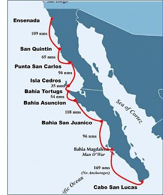
Back-up plan is to use the GPS waypoints from the Rains' guides in "Mexico Boating Guide" for Baja, and when I make it to mainland Mexico, the waypoints from Blue Latitude's guides (waypoints can be downloaded for a modest fee to prevent fat-finger errors).

Finally, will be heavy on the "Old School" techniques of being very conservative. From time to time I mention that in 1542 (?) Sir Francis Drake careened his Golden Hind on the shores of what is now Drakes Bay, 25 nms north of the Golden Gate. Why there instead of somewhere in SF Bay? Because he didn't know SF existed. With prevailing weather making the Pacific Coast a lee-shore, and Drake having no charts to speak of, he held well-off the coast and simply missed San Francisco Bay. If you could see my routes and approaches, you would see very conservative waypoints. And as I've already posted, I time my arrivals, not my departures, meaning I want to be somewhere by about lunchtime. For me, significantly more conservative than my old delivery methods where I had confidence and knowledge.

So, that's my plan. TT - would welcome your input. I have a lot of respect for your experience and knowledge.

Peter
 
Last edited:
Personally, in unfamiliar areas, I like to have at least 2 sources of chart data handy. Satellite images are a good idea as well. Then when something doesn't match up (or doesn't match what your eyes are seeing) you know that there's bad information somewhere and can try to figure out what's correct.
 
North of Frailes is Bahia Muertos, a good overnight stop if you don’t want to go straight from Frailes, good anchorage, restaurant on site.

I was going to suggest this, particularly since La Paz is best entered with good daylight and visibility.

As an added attraction, there is a palapa-type bar on the beach at Bahia Muertos. The winds can come up strongly, but we held well.
 
Personally, in unfamiliar areas, I like to have at least 2 sources of chart data handy. Satellite images are a good idea as well. Then when something doesn't match up (or doesn't match what your eyes are seeing) you know that there's bad information somewhere and can try to figure out what's correct.

In my experience along the Baja coast, there is no accurate chart and most repeat the inaccuracies of others. For that reason, we avoid new (to us) waters of less than 100 fathoms except during daylight, and even then proceed at about 6 knots with a careful eye on both fishfinder and scanning sonar.

Once we suddenly came upon a shallow reef (shallow enough to have damaged our running gear, or worse) at least 1 mile from land (an island we were fishing) -- which isn't entirely surprising since marked obstructions are often miss-located by 1/4 mile or more. I was running the boat from the Portuguese bridge and from that vantage could easily see the reef. But the reef turned out to be a very dense school (?) of red crabs.


In that case, I'd want to use sonar (as you do) plus radar to help correlate the chart data to reality. For the depth portion, I wonder if enough people submit data to things like the Navionics Sonar Charts to make those useful.
 
Personally, in unfamiliar areas, I like to have at least 2 sources of chart data handy. Satellite images are a good idea as well. Then when something doesn't match up (or doesn't match what your eyes are seeing) you know that there's bad information somewhere and can try to figure out what's correct.
My dad used to say "A man with a timepiece always knows what time it is. A man with two is never sure."

OpenCPN has many fans, but I find it very difficult to use. The instructions are wordy and introduce more questions than they answer, often starting from a screen that i have no idea how they got there. But....they have a feature where you can download current Google Earth and use that as the underlay to your chartplotter and waypoints (MBTiles). I just need to figure it out. I've seen some breadcrumbs that MBTile files may be usable on Coastal Explorer which would be great.

But bottom line is navigation in US waters is a cakewalk compared to lessor developed countries. It turns out its expensive to create and maintain accurate navigation charts so only the commercial lanes are maintained. Satellite imagery and crowd-sourced bathymetry will eventually change that.

Peter
 
In that case, I'd want to use sonar (as you do) plus radar to help correlate the chart data to reality. For the depth portion, I wonder if enough people submit data to things like the Navionics Sonar Charts to make those useful.
The aforementioned examples of CMAP not showing a major breakwater and seeing my boat shown on a beach really rattle me. For Mexico, will rely more on guidebooks that have history, and a large dose of conservatism coupled with discipline since I am sure that when on the water, the waypoints will seem extremely conservative.

I am in the process of triaging my gear I had stowed in a Ensenada storage locker. I found some old paper charts from a trip from Newport Beach to San Francisco on 1991 (before my 100T license - I was crew). Chartplotters didn't exist yet, at least not for recreational boats. We had a Loran so every hour or two I'd take thr Lat/Long off the Loran, then plot it on the paper chart. Quite the jolt to see my scribbling from 30 years ago. It was a different time where you adjusted your route based on the information at hand. It's been a while, but the premise is the same. And surprisingly cruising guides are still relevant not just for general information, but navigation.

Peter
 
For good reason, FUBAR, CUBAR and Bahaha have put together decent if not excellent navigation guides and advisements for travels down the Baja. This group trip south has safely opened up cruising the Baja with less than good charting to guide the way.
 
Have you guys settled on charts? My experience is about 5 years old at this point, but back then the c-map charts were dangerously inaccurate. Navionics was a bunch better, but still problematic in many areas. For any place where I would come close to land, especially anchorages, I would cross check everything again satellite images. I'd suggest making certain that you have them on your chart plotter. More often than not, the charts were not correctly geo-referenced. For example, Puerto Escondido is shown with no details on c-map, and and is miss-located by about 1/2 nm.

What I have are cmap charts on my plotters and navionics on my ipad.

My intention is to use these and also use my cruising guide which provides real cruiser observations.

We are also not traveling at night except for the last leg, and then we will leave before light as opposed to coming into port after dark.
 
Last edited:
For good reason, FUBAR, CUBAR and Bahaha have put together decent if not excellent navigation guides and advisements for travels down the Baja. This group trip south has safely opened up cruising the Baja with less than good charting to guide the way.

CUBAR site still cites Pat Rains' description of the trip HERE (Pat Rains is the author of the Mexico Boating Guide). CUBAR (ex FUBAR) closely follows the Baja Ha Ha route with exception of starting in Ensenada to do paperwork cha cha there (Ha Ha starts in San Diego). And CUBAR stops in Turtle Bay for fuel whereas Ha Ha drops anchor just north of Turtle Bay in Santa Maria. My guess is the need for fuel is why the entrance paperwork is done in Ensenada - getting fuel without clearing aduana is likely a no-no.

When I did the 2006 Ha Ha on a friend's Willard 40, the rally organizers provided very little navigational advice - in fact, they purposely shied away from any. I remember at the Captain's Meeting someone asked about going between Cedros Island and the mainland. Answer was "you're on your own to make decisions based on boat, crew, circumstances." Happens to be the right answer, but my guess is the CUBAR fleet has a more curated course (BTW - no problem going between Cedros and Mainland).

Regardless, both CUBAR and Baja Ha Ha have two relatively long legs - 285 nms; 275 nms; 175 nms. Up until the recent threads by Kevin (KSanders) and Doug (AKDoug), I hadn't realized there we as many anchorage possibilities are there are. As mentioned up-thread, I am trying to supress my delivery-skipper tendencies which adores multi-day runs in consideration of my best friend/wife/crew/potential-mutineer. So stops other than the two Ha-Ha/CUBAR stops are of interest.

Peter
 
GPS to chart actual location inaccuracy is a real issue, On a trip down Baja a couple times back I personally saw our boat on the beach issue on our plotter off Cedros. I typically use three sources of charting ( 2 electronic, 1 paper) plus a Baja cruising guide and compare those to info from the sounder and radar. I will typically use the radar as my base guide as it doesnt lie.

I know it gives some who have not done significant overnight offshore voyaging the creeps to power along in the dark, It took me a bit to get used to it too. But off the coast of Baja the winds typically die down at night and the ride can be much better.

If the boat sticks to a reasonable watch schedule you can get in the groove and you actually can get more sleep than one does in normal life. I have written this before here.. the Admiral and I still do long driving trips this way and it works for us. There is nothing better that doing a run down Baja when you take advantage of the moon and plan you trip accordingly. It has felt at times that there is a big streetlight on lighting the way. On a side note, while many of the stops shown on the chart previously posted are "anchorages" I have spent nights anchored in some of these that were so swelly no one slept and we were worse in the am.


The trip down is a fun one, but it can be a hit and miss event that weather can make it fantastic.. or pretty arduous. Even with that I always look forward to my next trip to Baja

HOLLYWOOD
 
I am carrying a sea anchor with the plan to deploy it in very light weather on the couple of long passages, just enough to keep the bow into the swells and get a few hours of sleep. The possibilities of running into nets at night diminish when you're not running under power :) Also plan to use the undersized sea anchor to fish when the wind is trying to push me off my spot, it's a 15' anchor not the recommended 30' storm anchor.

I may never deploy it, but then again... I am hoping to not need my backup anchor rode and anchor either. I have two 450' 5/8" nylon anchor lines, multi use, and a 3K Rocna dingy anchor (in addition to my 10K Rocna spare) I plan to use for my stern line anchorage off the beach to stay bow into the swells. No rocker stoppers or paravanes, and I like to sleep!
 

Latest posts

Back
Top Bottom