Not looking good. Living in Florida you have to expect these but one could hope that the forecasters are wrong. Crap!
You are using an out of date browser. It may not display this or other websites correctly.
You should upgrade or use an alternative browser.
You should upgrade or use an alternative browser.
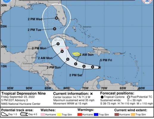
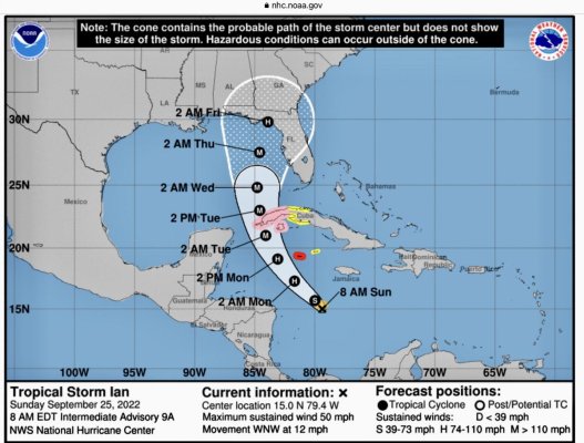
Hurricane Ian was Tropical Storm Ian was Tropical Depression 09
- Thread starter Larry M
- Start date
The friendliest place on the web for anyone who enjoys boating.
If you have answers, please help by responding to the unanswered posts.
If you have answers, please help by responding to the unanswered posts.
RT Firefly
Enigma
Greetings,
Yep. Don't look good.
Yep. Don't look good.
Benthic2
Guru
If you are in Jaxsonville, you have a lot less to worry about than those in the south west parts of Florida.......The storm will weaken considerably as it travels over land without the warm water to sustain it.......and 8 or 9 days out things can change drastically.
mvweebles
Guru
- Joined
- Mar 21, 2019
- Messages
- 7,222
- Location
- United States
- Vessel Name
- Weebles
- Vessel Make
- 1970 Willard 36 Trawler
The thing I hate about hurricane forecasts is the hope and prayer hand-wringing because it's a zero sum game. Right now, the "M" is right around Sarasota, which puts St Petersburg on the clean side, which is good for us, bad for Sarasota.
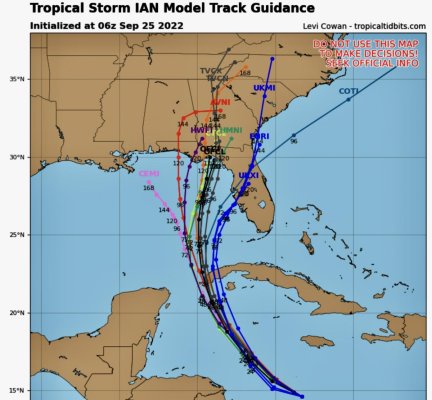
The models have a surprising amount of convergence right now.
Peter
The models have a surprising amount of convergence right now.
Peter
DWJensen
Veteran Member
- Joined
- Dec 2, 2021
- Messages
- 91
- Vessel Name
- Calypso
- Vessel Make
- Heritage East 36 Sundeck
I truly hate the fact that the current cone has the 2PM Weds "M" right on top of us. We've got the house sold and are ready to head out - Buyer's walkthrough is scheduled for Weds morning and closing is scheduled for Thurs AM. Hoping this storm will move to one side or the other...
OP
OP
If you are in Jaxsonville, you have a lot less to worry about than those in the south west parts of Florida.......The storm will weaken considerably as it travels over land without the warm water to sustain it.......and 8 or 9 days out things can change drastically.
I agree but disagree and hope you’re right that things can change
Winds and/or/storm surge plus winds are a big issue when a hurricane hits land but even when the storm is weakening or 100 miles away you can still be screwed. Jacksonville had 250 year flooding in 2017 with Irma. We live at less than 5’ above sea level.
markpj23
Senior Member
- Joined
- Mar 25, 2021
- Messages
- 197
- Vessel Name
- Black Horse
- Vessel Make
- Med Yachts 62
Spent the day taking down canvas, stowing deck chairs - all the fun stuff. If the current cone of uncertainty (remember agent 99?) holds true we will see a Cat 3 pass right over our marina  Really surprised that I was about the only one doing boat preps there today - my guess is tomorrow will be different...
Preparing the best I can and hoping for the best. Admiral and I will watch it all on the news while in Atlanta. Just too old and grumpy to deal with this hurricane crap on-scene anymore
Really surprised that I was about the only one doing boat preps there today - my guess is tomorrow will be different...Preparing the best I can and hoping for the best. Admiral and I will watch it all on the news while in Atlanta. Just too old and grumpy to deal with this hurricane crap on-scene anymore
Comodave
Moderator Emeritus
- Joined
- Jul 2, 2015
- Messages
- 21,283
- Location
- Au Gres, MI
- Vessel Name
- Black Dog
- Vessel Make
- Formula 41PC
Spent the day taking down canvas, stowing deck chairs - all the fun stuff. If the current cone of uncertainty (remember agent 99?) holds true we will see a Cat 3 pass right over our marina
Preparing the best I can and hoping for the best. Admiral and I will watch it all on the news while in Atlanta. Just too old and grumpy to deal with this hurricane crap on-scene anymore
We are doing boat prep too, except for the winter…
mvweebles
Guru
- Joined
- Mar 21, 2019
- Messages
- 7,222
- Location
- United States
- Vessel Name
- Weebles
- Vessel Make
- 1970 Willard 36 Trawler
Now TS Ian. No detectable change in course.

RT Firefly
Enigma
Last edited:
HTurner
Guru
- Joined
- May 21, 2021
- Messages
- 500
- Vessel Make
- Willard Vega Horizon
Moron weathermen (weatherpersons) could not pronounce Hermoine...
RT Firefly
Enigma
Greetings,
Windy forecasts it will cross Florida from Cape Coral to Satellite Beach then pay a visit Myrtle Beach, SC. Wherever it goes, stay safe. I will extend the same wish to those that are in the path of, now, TS Fiona...
https://halifax.citynews.ca/local-news/batten-down-the-hatches-fiona-arrives-today-5861239
Last edited:
OldDan1943
Guru
- Joined
- Oct 2, 2017
- Messages
- 10,595
- Location
- USA
- Vessel Name
- Kinja
- Vessel Make
- American Tug 34 #116 2008
greetings,
yep. Don't look good.

lol rt.
The thing I hate about hurricane forecasts is the hope and prayer hand-wringing because it's a zero sum game. Right now, the "M" is right around Sarasota, which puts St Petersburg on the clean side, which is good for us, bad for Sarasota.
The models have a surprising amount of convergence right now.
Peter View attachment 132287
With a Cat 4 it will be problematic no matter which side if its close enough and you are at or near the coast.
mvweebles
Guru
- Joined
- Mar 21, 2019
- Messages
- 7,222
- Location
- United States
- Vessel Name
- Weebles
- Vessel Make
- 1970 Willard 36 Trawler
All relative. Being 20 miles to the left of the centerline is a helluva better than being 20 miles to the right. May not make it good, but definitely makes a BIG difference.With a Cat 4 it will be problematic no matter which side if its close enough and you are at or near the coast.
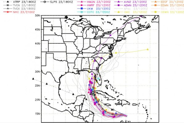
Latest NHC projection attached. Remarkably steady forecast.......for now
Peter

jleonard
Guru
- Joined
- Jun 25, 2008
- Messages
- 5,063
Yes better to be on the dry side.
OldDan1943
Guru
- Joined
- Oct 2, 2017
- Messages
- 10,595
- Location
- USA
- Vessel Name
- Kinja
- Vessel Make
- American Tug 34 #116 2008
I still remember when someone asked me, "What do you do when it rains?" to which I replied, "I generally stay inside and dry."
Last edited:
psneeld
Guru
I think I remember that the dangerous semi circle's real power is partially defined by the speed of the storm when it hits.
On the other hand, surface winds in the lesser semicircle are are often degraded by land based obstructions,, except where funneling occurs or tornadic activity....
On the other hand, surface winds in the lesser semicircle are are often degraded by land based obstructions,, except where funneling occurs or tornadic activity....
Last edited:
If the present forecast track holds, the west coast of Florida from the Keys to around Bradenton is in for major punishment. But, if the eyewall drifts just 40 miles to the west of the forecast track, it will make landfall someplace north of Clearwater. In that case, Tampa Bay itself will finally experience its "perfect storm" scenario, with hurricane-force winds out of the southwest pushing water through the Bay entrance causing major flooding all the way up its rivers and estuaries. If it doesn't happen with Hurricane Ian, it will eventually - just a matter of time. I love the Tampa Bay area - lived there for 25 years - but its vulnerability to this particular hurricane orientation is scary.
All relative. Being 20 miles to the left of the centerline is a helluva better than being 20 miles to the right. May not make it good, but definitely makes a BIG difference.
Latest NHC projection attached. Remarkably steady forecast.......for now
PeterView attachment 132299
Interactive SLOSH map3, for modeling...
https://www.nhc.noaa.gov/nationalsurge/?text#map
OldDan1943
Guru
- Joined
- Oct 2, 2017
- Messages
- 10,595
- Location
- USA
- Vessel Name
- Kinja
- Vessel Make
- American Tug 34 #116 2008
IF you choose to believe the projection, they shifted the models projections further west with a projected land fall around St Petersburg FL
jleonard
Guru
- Joined
- Jun 25, 2008
- Messages
- 5,063
I live just north of Clearwater in new port Richey and hope it drifts really far west and clears our area.
But is is what it is. I’ll be watching via my security cameras unless the power goes out as I’m currently in CT with our travel trailer
But is is what it is. I’ll be watching via my security cameras unless the power goes out as I’m currently in CT with our travel trailer
mvweebles
Guru
- Joined
- Mar 21, 2019
- Messages
- 7,222
- Location
- United States
- Vessel Name
- Weebles
- Vessel Make
- 1970 Willard 36 Trawler
I have wondered about wind-surge pushing up Tampa Bay. I was a presenter at a TrawlerFest in Solomons MD in the early 2000s. That year, a hurricane had swept up the Chesapeake a few weeks prior (Isabel?). The surge floated docks over their pilings, and when the water ran out, created an ultra-low tide. A lot of damage, just from the wind-pushed surge up the bay.If the present forecast track holds, the west coast of Florida from the Keys to around Bradenton is in for major punishment. But, if the eyewall drifts just 40 miles to the west of the forecast track, it will make landfall someplace north of Clearwater. In that case, Tampa Bay itself will finally experience its "perfect storm" scenario, with hurricane-force winds out of the southwest pushing water through the Bay entrance causing major flooding all the way up its rivers and estuaries. If it doesn't happen with Hurricane Ian, it will eventually - just a matter of time. I love the Tampa Bay area - lived there for 25 years - but its vulnerability to this particular hurricane orientation is scary.
When Irma came through in 2017, I was living in St Pete. I was pretty sure my house was a goner when I left to stay with friends in Ocala. However, Irma veered inland placing us on the "clean" side, however JAX was hit pretty hard. We had bo property damage, but sure had a lot of yard cleanup to do.
Seems there are natural threats in all my adopted homes. SF had earthquakes, mountain cabin in Colorado has wildfires.
Peter
Kuncicky
Veteran Member
- Joined
- May 7, 2021
- Messages
- 88
- Vessel Name
- Betty L
- Vessel Make
- 1973 Gulfstar
My neighbor, who is older than Methuselah and has lived on the northern Gulf coast all his life, says that right now if he had a boat at Apalachicola or Carrabelle, that he would be very worried. He thinks the eye will come ashore over there, no matter what anyone else may think. Who knows? Not me.
HTurner
Guru
- Joined
- May 21, 2021
- Messages
- 500
- Vessel Make
- Willard Vega Horizon
My neighbor, who is older than Methuselah and has lived on the northern Gulf coast all his life, says that right now if he had a boat at Apalachicola or Carrabelle, that he would be very worried. He thinks the eye will come ashore over there, no matter what anyone else may think. Who knows? Not me.
I think he may be right...
My neighbor, who is older than Methuselah and has lived on the northern Gulf coast all his life, says that right now if he had a boat at Apalachicola or Carrabelle, that he would be very worried. He thinks the eye will come ashore over there, no matter what anyone else may think. Who knows? Not me.
The 11 PM EDT advisory would seem to bear your friend's worries out, but Ian is still four-plus days away. There's a lot of worrying yet to be done.
The point of landfall, just a few miles either way, certainly can make all the difference - just ask the folks in Panama City who experienced Hurricane Michael on October 10, 2018. But even twelve hours out, predicting the point of landfall is a fool's game. Honestly, anytime a Big One takes aim at the eastern Gulf of Mexico, boaters everywhere along the coast should check their insurance, prepare as best they can and then lace-up their running shoes.
OP
OP
Kuncicky
Veteran Member
- Joined
- May 7, 2021
- Messages
- 88
- Vessel Name
- Betty L
- Vessel Make
- 1973 Gulfstar
I think he may be right...
Yeah, he was cackling a bit this morning when I went over and had coffee with him. Well, we will just have to wait and see what happens.
RT Firefly
Enigma
Greetings,
While everyone is rightly concerned about Ian, take a moment and see what devastation Fiona has brought to the Canadian Maritimes.
https://www.cbc.ca/news/canada/newfoundland-labrador
https://www.cbc.ca/news/canada/nova-scotia
I think there are a few TF members in that region.
While everyone is rightly concerned about Ian, take a moment and see what devastation Fiona has brought to the Canadian Maritimes.
https://www.cbc.ca/news/canada/newfoundland-labrador
https://www.cbc.ca/news/canada/nova-scotia
I think there are a few TF members in that region.