Lopez Island Grounding

The friendliest place on the web for anyone who enjoys boating.
If you have answers, please help by responding to the unanswered posts.

Eastsounder

Veteran Member
Joined
Feb 8, 2014
Messages
36
Location
USA
Vessel Name
Keeper
Vessel Make
1972 Grand Banks 32'
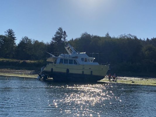
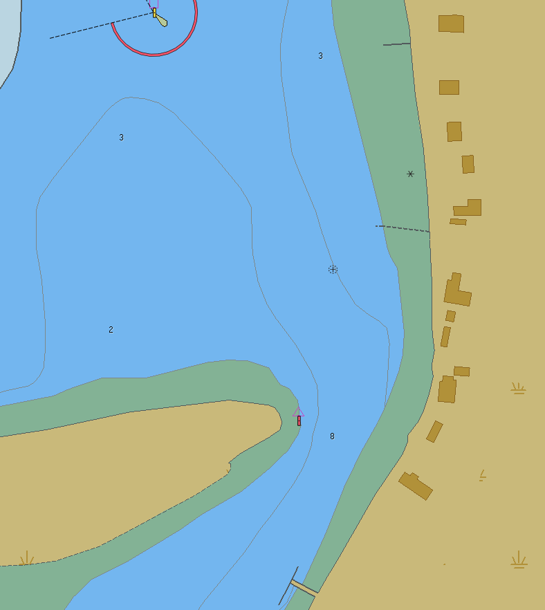
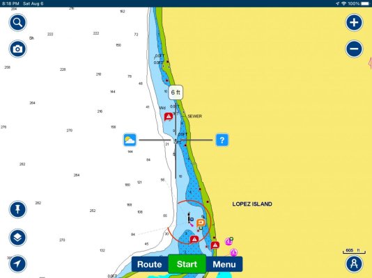
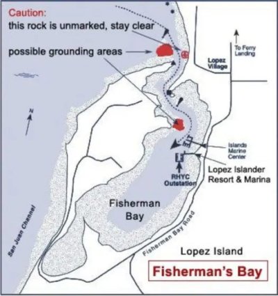
First Mate and I were tied up at a slip at Island Marine Center in Fisherman Bay, Lopez Island (in the San Juans) last evening. Watching a show in the berth when a Coast Guard helicopter started hovering at low altitude near the dock. From the flybridge I could see that it was directly above a large trawler-style yacht that was listing to port, obviously taking on water. Turns out it had hit a rock in the channel and was heading toward the beach so as not to sink in deeper water. This morning at low tide it’s high and dry. Efforts are underway to patch the gouge near the bow with bondo or some such. It’s an Arcturos 50 (also named Arcturos). Bad day for her captain and crew.
 

Attachments

  • 689B6505-4C55-46BB-8FF8-4557EA28D83B.jpg
    689B6505-4C55-46BB-8FF8-4557EA28D83B.jpg
    159.1 KB · Views: 189
A quick patch would most likely be 1/4” plywood & epoxy. Bondo would fail immediately.
 
The entrance to Fisherman's Bay has claimed many boats over the years, usually at low water.
 
A bad day, all right, but they were lucky to have enough time to get her to the beach.
 
"...hit a rock in the channel" I think I'd change that to "hit a rock"
 
"...hit a rock in the channel" I think I'd change that to "hit a rock"

Well said. That channel is " awkward",but clearly marked, charted and much discussed in the literature.
 
The entrance to Fisherman's Bay has claimed many boats over the years, usually at low water.

Yes the combination of the twists along with the current flowing through there makes it easy to get out of the channel quickly before realizing it. One of the few tricky entrances in the SJ Islands.
 
Wow sounds like he made the right move after the collision. In today's tight insurance market, I wonder if he'd be better off not reporting this to his insurance company and just pay for the repairs out of pocket...
 
Yes the combination of the twists along with the current flowing through there makes it easy to get out of the channel quickly before realizing it. One of the few tricky entrances in the SJ Islands.

Another one, in the Gulf Islands, is Pirates Cove. Both cause a pucker factor for me at half tide or less.
 
If it is a tricky channel, you would think he would have been making way slowly. If he was making way slowly, you would think it might not punch a hole in the hull? Surprising and somewhat disappointing. I have sort of hoped to survive a mistake like that without taking on water.....
 
I wonder if he hit the rock that is marked on the chart just outside the mouth of the entrance? I always pay special attention on my way at that location and also at the dog leg after I'm inside.

18967-albums1148-picture7691.png
 
I wonder if he hit the rock that is marked on the chart just outside the mouth of the entrance? I always pay special attention on my way at that location and also at the dog leg after I'm inside.

18967-albums1148-picture7691.png
That rock on your chart screenshot is indeed notorious and is inside the blue area of the channel. Not sure if that’s the one he hit, but seems likely. Oddly the tide at the time was nearing the day’s high. Learned later that the hull is aluminum, fwiw.
 
Any more details Ken?

Entering Pirates Cove on DeCourcey Island, you steer directly to the beach, marked with an arrow in someone's yard. When clear of the rocks to port, you take a 90 degree left turn and stay to port of a bouy marking shallows on the stbd side. On your left is a rocky ledge that is visible. At high tide, none of this is a problem. But half tide or less, it's very critical or you will be too shallow on either side. At zero tide, small boats only. Once inside, it's about 12 ft max depth at low tide, best case, with limited swing room. Great protected anchorage, but with significant limitations.
 
Last edited:
There is a port and starboard markers, you favour the starboard side. The reason I asked for details is I know pirates cove and there is a reef many anchor close to and swing over. Got a link to the story?
Pirates cove.jpg
 
Last edited:
I don't have any photos or a link with better details but I know the reef you are talking about. As you enter Pirates, the reef is directly ahead of you, beyond the dinghy dock on your left. It's visible at lower tides, and yes, many boats have swung over it to their detriment.
 
marinetraffic.com plot

Earlier today, I put ARCTUROS into marinetraffic.com and looked at the her past track and speed. I plotted the location of a speed reduction to Navionics and the position is marked by the “crosshairs” on the attached screen shot.

Not any conclusion, but the information indicates to me that the incident did not occur in the entrance channel. Indeed the entrance-proper has soured many weekends…we have seen it ourselves.

To be clear, I am NOT slinging mud here…only pointing out the probable location for safety and awareness of ourselves and others.
 

Attachments

  • A207AA5D-AA3A-43D0-B144-8062130957E3.jpg
    A207AA5D-AA3A-43D0-B144-8062130957E3.jpg
    73.7 KB · Views: 101
When I am cruising to a new location I try to research the route, look information about entrances to anchorages and the anchorages themselves. The first time I went into Fisherman Bay I poked around on the internet. The marina https://lopezfun.com/marina/ in the bay had a good description of the hazards which I appreciated.

Cruising guides usually have similar info so to the newbies out there don't let this scare you away. A little research and planning can go a long way to having a safe cruise. Second don't follow an "auto route" from Navionics or similar software to get you into something like this. At the end of the day you need to navigate in hazardous waters vs software. It will be interesting to learn if this was an navigation error or mechanical issue at a really bad time.
 

Attachments

  • fisherman-bay-map.jpg
    fisherman-bay-map.jpg
    57 KB · Views: 48
Earlier today, I put ARCTUROS into marinetraffic.com and looked at the her past track and speed. I plotted the location of a speed reduction to Navionics and the position is marked by the “crosshairs” on the attached screen shot.

Not any conclusion, but the information indicates to me that the incident did not occur in the entrance channel. Indeed the entrance-proper has soured many weekends…we have seen it ourselves.

To be clear, I am NOT slinging mud here…only pointing out the probable location for safety and awareness of ourselves and others.

Nice work!
 
It will be interesting to learn if this was an navigation error or mechanical issue at a really bad time.
Yes it will.
Like Irene, I'm not slinging mud, but with local 'incidents" up tenfold this season, I wonder about the experience level of many of todays boaters.
 
Got a link to the story?
There's a disconnect here. Ken E was just pointing out the approach similarities of Pirates Cove and Fisherman's Bay. No story.

Squitty Bay on Lasqueti, Smuggler Cove and two or three on Nelson Island are tight as well. Ever been into Hidden Basin?
 
Yes it will.
Like Irene, I'm not slinging mud, but with local 'incidents" up tenfold this season, I wonder about the experience level of many of todays boaters.

Not knowing any details of this incident —-

With more and more use of plug and play navigation accidents can arise. Dead reckoning, range markers, physical buoy locations and paper charts remain a viable first choice in many cases.
 
Not knowing any details of this incident —-

With more and more use of plug and play navigation accidents can arise. Dead reckoning, range markers, physical buoy locations and paper charts remain a viable first choice in many cases.

Amen!
 
Happy news re: Arcturos: We encountered her at about 1045 today making good headway traveling SSW shortly after rounding Humphrey Head (on Lopez Island). She had a TowboatUS escort, but she was traveling under her own power, apparently heading to Anacortes. I was surprised and delighted to see her distinctive yellow hull moving smartly through the water, so soon after her near disaster. Viva Arcturos!
 
Great looking boat. Congrats to the Captain who did a great job minimizing damage and risk of sinking. I can only imagine the stress on board when he heard the "crunch!". I too would have thought that aluminum hull would have survived a bump into a rock. I chose a steel hulled boat for that purpose and plan to head up into Alaska where charts are likely far from perfect.
 
It’s an Arcturos 50 (also named Arcturos).

That is often done for boats used in boat shows by the vendor or dealers. I've sometimes seen it with the size "<name> 50".

I hope that wasn't a relocation by the vendor's relocation crew.
 
I saw Arcturos for sale on South Lake Union in Seattle. Beautiful boat. Glad to see it was saved. I'd be curious as to what was used for a patch and what was used to make it stick to the aluminum. Maybe they had time to weld a piece of aluminum to the hull?
 
I saw the boat on the hard in La Conner yesterday. It looked like a crack on the keel at the bow had been patched with something like MarineTex. There were also some nasty dents on either side, maybe 6 or 8 inches wide and an inch or two deep. It must have hit pretty hard to dent it like that.
 
I saw the boat on the hard in La Conner yesterday. It looked like a crack on the keel at the bow had been patched with something like MarineTex. There were also some nasty dents on either side, maybe 6 or 8 inches wide and an inch or two deep. It must have hit pretty hard to dent it like that.
Great info. Thanks.
 
Back
Top Bottom