You are using an out of date browser. It may not display this or other websites correctly.
You should upgrade or use an alternative browser.
You should upgrade or use an alternative browser.
Keku Strait conditions
- Thread starter DDW
- Start date
The friendliest place on the web for anyone who enjoys boating.
If you have answers, please help by responding to the unanswered posts.
If you have answers, please help by responding to the unanswered posts.
Ken E.
Guru
- Joined
- Nov 12, 2016
- Messages
- 1,974
- Location
- United States
- Vessel Name
- Hatt Trick
- Vessel Make
- 45' Hatteras Convertible
Went through there the summer before Covid, north to south. Taken at slack current at high water, it was pretty uneventful. Two qualifiers on that though. You asked about bouyage. The red pin marking the upper side of the elbow on the east side was missing. That's a problem because it's a turning point that marks the channel and it's very shallow on either side of the slot. Secondly, south of the elbow was solid bull kelp. And I mean solid. So much so that it took a lot of power to move through it with a concern that the engines' water intakes would be plugged. That didn't happen but I did stop as I neared Sumner Strait to back down for quite a while to clear it. A sailboat or power boat with low power would have a tustle getting through there. I reported the missing bouy to the Coast Guard. As far as the kelp, I don't know if it is better or worse.
tpbrady
Guru
Yes, 3 times last year. A couple of missing markers (no buoys to speak of) but nothing critical. I generally look for slack current or slightly before at Devils Elbow. Later in the year, kelp might be a small problem especially with a lot of sunny days. Last year wasn’t too bad. I have a Coastal Explorer route I follow and generally let the auto pilot drive while I’m standing at the helm watching sonar and current.
Tom
Tom
Ken E.
Guru
- Joined
- Nov 12, 2016
- Messages
- 1,974
- Location
- United States
- Vessel Name
- Hatt Trick
- Vessel Make
- 45' Hatteras Convertible
Lots of good, protected anchorages around the Kake area to stage for a n -> s run through Rocky Pass at slack.
Last edited:
tpbrady
Guru
I use the tide charts embedded in Coastal Explorer which I believe are sourced from NOAA. They are generally pretty good but in Wrangell Narrows they don’t seem to ever reflect what’s happening. I don’t know how to explain it, but the general recommendation is to time your travel to reach the point where the current swings 180, supposedly around marker 48-49. But I have left Petersburg just before high tide and been running against the tide all the way to Sumner St. The other approach is to time getting to Petersburg going north at slack tide to make docking nearest the town/harbor master with out a 2 knot tide that swirls around the dock.
The kelp in Keku isn’t that thick and the more boats that go through help keep it clear, kind of like mowing the grass. Because it isn’t that thick, the sonar works pretty well.
Tom
The kelp in Keku isn’t that thick and the more boats that go through help keep it clear, kind of like mowing the grass. Because it isn’t that thick, the sonar works pretty well.
Tom
Thanks again, very helpful. I've only been north as far as Wrangell (2019) so new to me north of there.
I've got Ports and Passes, the Noaa predictions, the Navionics predictions, and whatever comes in OpenCpn. Sometimes these are pretty close to each other, but other locations they are practically opposite.
I've got Ports and Passes, the Noaa predictions, the Navionics predictions, and whatever comes in OpenCpn. Sometimes these are pretty close to each other, but other locations they are practically opposite.
Jon H
Senior Member
I have transited Rocky Pass several times in last couple of years including
last year, all NB.
The winter of 20/21 definitely did some ice damage to the ATONS, don't know
what this past winter did or did not due.
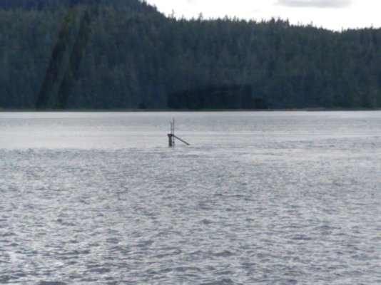
As previously mentioned, the R"14" Buoy at Devils Elbow was missing but
all the Green Daymarks at DE were intact.
Both Daymarks G"39" + G"41" were damaged.
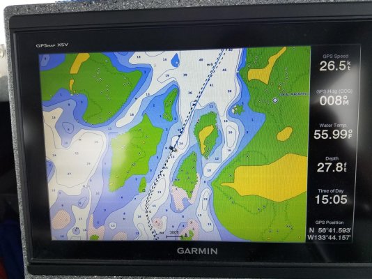
My Garmin display worked well, I also studied the paper charts beforehand.
last year, all NB.
The winter of 20/21 definitely did some ice damage to the ATONS, don't know
what this past winter did or did not due.
As previously mentioned, the R"14" Buoy at Devils Elbow was missing but
all the Green Daymarks at DE were intact.
Both Daymarks G"39" + G"41" were damaged.
My Garmin display worked well, I also studied the paper charts beforehand.
Attachments
Jon H
Senior Member
DDW -
I have the pre-loaded charts that come with Garmin.
My only complaint is the buoys, daymarks, etc. are not as
large or intensely colored as they are on a paper chart.
As far as accuracy goes, they seem very good.
I have the pre-loaded charts that come with Garmin.
My only complaint is the buoys, daymarks, etc. are not as
large or intensely colored as they are on a paper chart.
As far as accuracy goes, they seem very good.
Ken E.
Guru
- Joined
- Nov 12, 2016
- Messages
- 1,974
- Location
- United States
- Vessel Name
- Hatt Trick
- Vessel Make
- 45' Hatteras Convertible
Just a thought for those of us who use Rocky Pass in the summer. After a transit through there, post a brief update here on TF on bouys, day marks, kelp or anything else noteworthy. I intend to do this in the future. It would be very useful to have this information if you were considering using this route.
Nomad Willy
Guru
I went through Rocky Pass running from Kake (where we were visiting) to Thorne Bay where we were living at the time.
We left Kake late planing to anchor in St. John’s Bay. But there was so much fishing gear in the bay there was no place to anchor.
Going south in the pass we found a small anchorage (it was an anchorage because we anchored there) at the mouth of a headwater of some sort. I tried several anchors including a Forfjord but the only anchor having any bite at all was an “S” type Danforth.
I wanted to go through Rocky Pass mostly because my father talked much about it in the past. He went there usually from Angoon w his longtime friend Rod Darnelle. They went there in Rod’s old wood planked 26’ Chris Craft cabin cruiser. This was in the late 40’s and early 50’s. They went there mostly to hunt and St. John’s Bay was the favorite spot.
There’s hardly any reason for a yachtsman to go there other than looking for trouble. Dad liked a challenge and probably talked about Rocky Pass to appear fearless as most everyone else did. I may have gone into Fjord’s Terror (off Endicott Arm) for that reason (partially for bragging rights) as well and there’s even less good reason to go there.
But re Rocky pass, now that I’m rocking chair old I’d avoid it. A lot of staying right on top of it for hours (that can be tiring) and upping the chance of making a mistake. My take is basically that there’s not much to gain but lot’s to loose.
But if you “need” to go do it early is better as late has much more kelp.
tpbrady
Guru
I use Rocky Pass when north bound to Sitka or Hoonah/Juneau. Leaving from Wrangell I go to Port Protection or Labouchere Bay, so I can time the slack and high tide at Devils Elbow. You can transit Sumner St on an outbound tide. Going south, I prefer using Wrangell Narrows since when you plan the tides in either place, you are always running against an out bound tide in Sumner which runs as high as 1.5 kts.
Tom
Tom
twistedtree
Guru
68' boat, 7.5' draft. Too much for Rocky Pass this time of year at high slack?
Ken E.
Guru
- Joined
- Nov 12, 2016
- Messages
- 1,974
- Location
- United States
- Vessel Name
- Hatt Trick
- Vessel Make
- 45' Hatteras Convertible
TT, don't do it, unless your Norhavn has wheels on the bottom.
Last edited:
sunchaser
Guru
- Joined
- Apr 9, 2008
- Messages
- 10,196
- Location
- usa
- Vessel Name
- sunchaser V
- Vessel Make
- DeFever 48 (sold)
I don't need the bragging rights, but if you are coming down the Chatham and bound for the west side of Prince of Wales, the Wrangell Narrows would seem to be the long way around.
In decent weather continue South on Chatham to Coronation Island, head East and you're then on the West side of POW Island. I'm leery of Keku due to kelp and stabilizer fouling.
In decent weather continue South on Chatham to Coronation Island, head East and you're then on the West side of POW Island. I'm leery of Keku due to kelp and stabilizer fouling.
With 48' of stabilized boat, the south end of the Chatham doesn't sound too bad. But pretty open water for 34' and no stabilizers. I wouldn't have a problem with that in my sailboat. In the trawler, could be pretty uncomfortable.
What is considered "early" and "late" for kelp?
sunchaser
Guru
- Joined
- Apr 9, 2008
- Messages
- 10,196
- Location
- usa
- Vessel Name
- sunchaser V
- Vessel Make
- DeFever 48 (sold)
With 48' of stabilized boat, the south end of the Chatham doesn't sound too bad. But pretty open water for 34' and no stabilizers. I wouldn't have a problem with that in my sailboat. In the trawler, could be pretty uncomfortable.
What is considered "early" and "late" for kelp?
To get to Chatham, Cape Caution and Dixon Entrance pose open water “concerns” too. In a single engine 34’ vessel Keku should be quite doable. TP Brady knows the area well for timing the passage, as already indicated.
tpbrady
Guru
DDW,
The east side is the best route down Chatham as it gives you a lot places to hide out. We have hidden out in Rowan, Tebenkof, and Port Malmesbury waiting for winds to calm down. On the west side there some nice bays but get a lot of big yacht/charter traffic and you end up at Port Alexander which is a nice place but kind of the end of the road. You can cross to Coronation Island or cross back to the east side, but it can be like a slightly smaller version of the Dixon Entrance. We crossed from Coronation to Port Alexander with a good forecast of 10kts out of the south with an inbound tide and a 3 foot swell. That turned into 20kts out of the north after an hour of a 3 hour crossing. The dog wasn’t happy, but it turned into a calm sunny day in Port Alexander.
The east side is the best route down Chatham as it gives you a lot places to hide out. We have hidden out in Rowan, Tebenkof, and Port Malmesbury waiting for winds to calm down. On the west side there some nice bays but get a lot of big yacht/charter traffic and you end up at Port Alexander which is a nice place but kind of the end of the road. You can cross to Coronation Island or cross back to the east side, but it can be like a slightly smaller version of the Dixon Entrance. We crossed from Coronation to Port Alexander with a good forecast of 10kts out of the south with an inbound tide and a 3 foot swell. That turned into 20kts out of the north after an hour of a 3 hour crossing. The dog wasn’t happy, but it turned into a calm sunny day in Port Alexander.
tpbrady
Guru
Just went through Rocky Pass and aside from missing and bent day markers, the biggest Navaid problem seems to be buoy 14 at Devils Elbow is not at Devils Elbow but about .4 nm west up next to an island. No kelp at this time.
Tom
Tom
Alaskan Sea-Duction
Guru
- Joined
- Jul 6, 2012
- Messages
- 8,058
- Location
- USA
- Vessel Name
- Alaskan Sea-Duction
- Vessel Make
- 1988 M/Y Camargue YachtFisher
So why risk going through Rocky Pass? Or is it all hype?
We use Wrangell Narrows all the time. What happened to "Its not the destination, rather the cruise?
Besides the Admiral love Thomas Bay, where she claims to have heard Big Foot!!! LOL
We use Wrangell Narrows all the time. What happened to "Its not the destination, rather the cruise?
Besides the Admiral love Thomas Bay, where she claims to have heard Big Foot!!! LOL
tpbrady
Guru
Tom,
I think it’s all or mostly hype. It’s no more risky than Wrangell Narrows on a sunny day with small boat fishermen all over, seiners, a possible ferry, tow/barge, and water skiers. If you are comfortable on small rivers with a big boat their are no problems at high tide. I’ve never encountered opposing traffic in Rocky Pass and there are two places where it could be a problem. I view Dry Pass on POW as a more difficult but shorter.
Tom
Ken E.
Guru
- Joined
- Nov 12, 2016
- Messages
- 1,974
- Location
- United States
- Vessel Name
- Hatt Trick
- Vessel Make
- 45' Hatteras Convertible
So why risk going through Rocky Pass? Or is it all hype?
Tom, if you go through Rocky Pass at high water, slack current, on a day with good visibility and reasonable winds, to me it isn't any more risky than other tight, narrow places where most of us go. Before the first time we went through there, I had a chat with the original owner of NW Explorations, now deceased. He had been through Rocky Pass many times, including taking the NWX flotilla boats through there. When I heard that, it changed my view of the risk of going through.
As far as why use Rocky Pass at all, an example would be if you're in Sitka and you want to go to Craig, on the W side of POW. Your options are Chatham Strait which is open to the ocean at the south end and may or may not be rough on any particular day, or to go well east to Wrangell Narrows and then have to travel many miles back west to round Pt Baker at the NW end of POW. My biggest concern of going through is the kelp south of the elbow, which Tom Brady reported today as being sparse at present.
Intending to go through on the way south, so around the first week of August. Should I expect the kelp to be a lot thicker then?
In the mean time I've been comparing the Raymarine "fishing" charts (crowd sourced high res bathymetry) and the verdict is mixed. Often very more accurate that the official charts, but sometimes quite a way off. Comparing to the Bathy Live contours that the 3D sonar lays down as you drive. If I go through Rocky Pass, I'll be recording and comparing.
In the mean time I've been comparing the Raymarine "fishing" charts (crowd sourced high res bathymetry) and the verdict is mixed. Often very more accurate that the official charts, but sometimes quite a way off. Comparing to the Bathy Live contours that the 3D sonar lays down as you drive. If I go through Rocky Pass, I'll be recording and comparing.
Ken E.
Guru
- Joined
- Nov 12, 2016
- Messages
- 1,974
- Location
- United States
- Vessel Name
- Hatt Trick
- Vessel Make
- 45' Hatteras Convertible
The kelp is growing as the the weather warms. Keep your speed up and it likely won't be a problem in your size boat. Be sure to note Tom Brady's comments above on the position of bouy 14.
Similar threads
- Replies
- 5
- Views
- 978