Extreme Weather Event in SouthEast Queensland, Australia

The friendliest place on the web for anyone who enjoys boating.
If you have answers, please help by responding to the unanswered posts.

Peter B

Guru
Site Team
Joined
Jun 25, 2008
Messages
10,104
Location
Australia
Vessel Name
Now boatless - sold 6/2018
Vessel Make
Had a Clipper (CHB) 34
Folks, things are getting a bit hectic in our part of the world right now. A massive tropical low pressure rain band has been locked into place over the region by a blocking high, so the amounts of rain being deposited has been massively more than forecast. It is now fronting up as being worse than the previous records set in 1974 and 2011.


Tends to make the pandemic - or even Ukraine - a bit less pressing and a bit surreal for us right now.
 
Yeah it's getting bad
Thankfully where we are on the Gold Coast just wind and rain at this stage
Water is brown but no debris


Sinking yacht in this one
 
They are starting to call it the perfect storm - where two storm cells are coming together, but worse still, hardly moving...

Here on Bribie, being a small island, there are no rivers, and the streams have a short run to the sea, so apart from local accumulations in hollows that don't drain well, there is no flooding. However, we have had about 600mm over the last four days, so we are lucky it flows off into the sea quite quickly. However, the road to the bridge on the mainland side was closed for a time. It has now moved more south and away from us, so the rain has more or less ceased here, at least for now. Well, looking at the radar, not quite yet. Where we are on Bribie is the small bit of land visible just west of Cape Moreton, sort of under the 'ure' of Caboolture...
 

Attachments

  • Screen Shot 2022-02-27 at 1.45.32 pm.jpg
    Screen Shot 2022-02-27 at 1.45.32 pm.jpg
    87.5 KB · Views: 24
  • Screen Shot 2022-02-27 at 1.55.13 pm.jpg
    Screen Shot 2022-02-27 at 1.55.13 pm.jpg
    157 KB · Views: 21
Last edited:
We are heading for Green Cape Lighthouse, near Eden, tomorrow for five nights, after a cycling sojourn in Victoria. The low pressure system is coming down the coast and should hit us on Wednesday.

The lighthouse is at the end of a tricky 25 kilometre dirt road access,that becomes even trickier in wet weather. The light station is solar powered with diesel generator backup, so should be fun.

I bought a bottle of Old Horny Goat (mead) to while away the time.
 
Wow! I wish you the best of luck getting through all that!
 
Some affected Queensland and northern NSW areas had around 28 inches of rain in 24 hours. That`s a lot of water, some deaths, and a lot of rescues. Call went out for anyone with a boat to rescue a pregnant lady off a roof in Engine St Lismore, and for boatowners to assist with evacs generally.

It`s coming from what is called a river in the sky(isn`t there a song with that line in it?). Fortunately for Qld it`s moving south, unfortunately for us we are located south. Going to get ugly on Wednesday.

Here you go, Bruce; by the Welsh artist, Duffy (who had her own hellish experience a year or so ago). Wishing the best for y’all.

 
Thanks Ian. Persistent searching reveals the song in my errant mind was Stevie Wonder`s "Ribbon in the Sky". Close but you get the cigar.
 
Extreme weather from Queensland to the north is travelling south, becoming an "East Coast Low". Still lots of rescues from roof tops, and severe flooding.
Here`s a reminder of sea conditions associated with an ECL, featuring a traditional Sydney-Manly route ferry. The new catamaran ferries are not up to dealing with a 2M swell let alone this stuff, one flexed and popped a window.
 
You are right Bruce. Cases of amazing bravery and community spirit all over. Sadly this is going to go on for a long time. Here in SE Queensland we are being hit again.
This time heavy rain, destructive winds, and hail up to 6cm across. This, when they are all still out there trying to clean up from the floods of last week. It breaks your heart. https://www.couriermail.com.au/news...85764883&type=curated&position=1&overallPos=1
Even your floodwaters rose again, very tough on the locals, may it end soon. In Sydney, after overnight moderate to heavy rain (my drainage did its job including the trench I dug next door to divert surface water) there is some easing, but for how long. And the forecast potential rainfall today has been lowered. Major flooding of the Hawkesbury River is happening but I think the marina will be ok.(PS Courier Mail has a paywall, thanks Rupert)
 
(PS Courier Mail has a paywall, thanks Rupert)
Oh, sorry, because I subscribe, it opens for me anyway, but I saw somewhere they had opened up these 'breaking news' type warnings in the public interest. Is that not so..?
 
I've been thinking of you folks in Queensland. How are conditions today?

Saw this bit about a fellow on a cargo ship needing medical rescue. The RACQ helicopter apparently had to leave a paramedic on board overnight as the seas were too rough to take the patient off the ship by Life Flight.

Here is the story (no paywall on this site):

https://www.9news.com.au/national/queensland-nsw-floods-live-updates-latest-news-weather-warnings-rain-radar-forecast-march-3-2022-ballina-sydney-windsor-lismore/e2e72e76-ab48-4096-b1fa-9f5c3482ef59

Watching that video of the Manly ferry, I was sure it was going to broach when it made the turn (near end of video). Good Lord, that is a nasty sea state! And that double-ender ferry should go in the "Interesting Boats" thread.

Best Regards,
Mrs. Trombley


I hope you guys all come through this OK. It’s easy to ignore things like this when they are so far away, but please know we are thinking of you!
 
Those wonderful Manly ferries owe their design to older versions, many of which were built in the UK and came to Australia on their own bottom. Best example is SS South Steyne.The "Heads"(headlands)of Sydney Harbour bookend the direct opening to the ocean, in strong easterly conditions the ferry course goes out to between the Heads before "tacking" back in. That turn needs to be carefully timed to avoid broaching.
Southern Queensland and the coast north of a very lucky Sydney are still getting whacked. What happens next, where the Low heads, is hard to predict. There is still a lot of water to drain into the rivers, the land can absorb no more moisture.
800px-Sydney_Ferry_SOUTH_STEYNE_30_Dec_1970.jpg
 
Last edited:
Wifey B: We have a friend in Lismore. They live in a family home that has been in the family since the 20's. It's on a hill so hasn't flooded ever more than 4 or 5 bricks high on one corner. However, wiped out a lot of treasured photos and possessions and more family had to come in to help. Then in the middle of helping, her daughter got Covid, as people have relaxed on protocols in the midst of fighting flooding. Definitely record conditions. :ermm:
 
Those wonderful Manly ferries owe their design to older versions, many of which were built in the UK and came to Australia on their own bottom. Best example is SS South Steyne.The "Heads"(headlands)of Sydney Harbour bookend the direct opening to the ocean, in strong easterly conditions the ferry course goes out to between the Heads before "tacking" back in. That turn needs to be carefully timed to avoid broaching.
Southern Queensland and the coast north of a very lucky Sydney are still getting whacked. What happens next, where the Low heads, is hard to predict. There is still a lot of water to drain into the rivers, the land can absorb no more moisture.
800px-Sydney_Ferry_SOUTH_STEYNE_30_Dec_1970.jpg

Bruce
When weather kicks up do the ferry operators ask passengers to fill lower decks to improve CG? Is your vessel proving leak proof? Is the weather extreme called a tropical depression, cyclone or ?? A few years ago the Houston area had over a meter of rain during a late summer hurricane, it is hard to imagine these rain event extremes. Keep up the reporting and good luck.
 
The Brisbane River was closed by the Harbourmaster due to debris, and remains closed. Fines of up to $27,570 (for individuals) to encourage compliance.

At the City Gauge this time peak was 3.85m. In 2011 it was 4.46m, at which level the pontoons at Dockside Marina almost floated off the pylons. But some suburbs, both north and south, were much worse affected this time as their local watersheds were seperate to the river and received higher rainfall totals.

As in 2011 the biggest issue for the river is private floating concrete pontoons. Some are poorly secured, and some upstream simply float off the top of the piles as upstream flood levels get a lot higher. One such missile or torpedo lifted the bow of a 60ft racing yacht partly onto a finger walkway at Dockside. Then a cleat on the walkway punched a hull in the hull and it sank, A couple of days later it broke in half, just behind the mast. Pic shows stern sticking up....

The runaway pontoon is still wedged under the main walkway, a lot of which will need to be replaced due to broken structural timbers in it. Another runaway pontoon pierced the a hull of one of the City Cat catamaran ferries at Hawthorn. The Cat fully overturned and sank. A lot more property damage, too much to describe. Given these situations have now occurred twice there needs to be regulatory change regarding private pontoons on riverfront properties. If there is a third time of missiles/torpedo's then prosecutions for gross negligence would be warranted IMO.

Then there is the issue of water release from the dams while rain is still falling. Why were the flood compartments of the dams not fully utilised? How many homes would have flooded less or not at all had the dam releases (commenced 4am 27 Feb) been delayed by 24 or 48 hours. I am really annoyed by avoidable damage affecting many people, even though I have not been personally impacted.
 

Attachments

  • F9 yacht.jpg
    F9 yacht.jpg
    166.7 KB · Views: 14
Last edited:
Bruce
When weather kicks up do the ferry operators ask passengers to fill lower decks to improve CG? Is your vessel proving leak proof? Is the weather extreme called a tropical depression, cyclone or ?? A few years ago the Houston area had over a meter of rain during a late summer hurricane, it is hard to imagine these rain event extremes. Keep up the reporting and good luck.
Tom, The system is called an "east coast low". The weather guys distinguish it from the ones you identify, not sure how, but surely it is related. This year it`s much fortified by La Nina.
Sojourn stays surprisingly dry and fresh inside. Turned out a much better boat than I expected.
Manly ferry pax tend to head downstairs because the roll is so potentiated up top, and watching the bow go under is fun. Best ferry trip is the one before service gets suspended due to danger. On new ferries plying Sydney to Parramatta(inland) pax must go to the lower deck or be decapitated as it passes under a couple of bridges. Govt. design at it`s best!
Sydney has a brief respite today, then rain returns, the flood risk with it. Running low on dry undies!
Thanks for the good wishes. We`re having dinner tonight with the guys living 2 doors down,closest house to the creek you noted. They say it rises and falls, but no intrusion, may explore that tonite.
 
I found this from the BOM describing an east coast low, origins, characteristics. It has features of a cyclone,with up to Cat 2 winds possible. Sometimes they stall in one place for days. Barometer is falling quite rapidly at present, now lower than before/during the ECL.
East coast lows
 
We are experiencing strong flooding here in the Shoalhaven River presently. I am tied to a dock now, but last Thursday I had to get help from my Marine Rescue colleagues to get the huge amount of debris off my mooring lines, all in a 7kn current. It took three hours to remove it all, and then I took the cat around the corner to a friend's dock. 6m swells offshore predicted for tonight. A dozen boats dragged their anchors and some not rescued yet, as the conditions have been too bad. Where I am presently, the water level is high tide height, but it's low tide right now:
 

Attachments

  • IMG_7472.jpg
    IMG_7472.jpg
    100.4 KB · Views: 12
Floods Evans Head northern NSW 3 hours south of Brisbane

This note is a report from northern NSW flood zone.
Aquabelle is moored at Evans Head in northern NSW. When the Richmond River that exits to the ocean at Ballina floods, it overflows at Woodburn in sheet floods at Woodburn. This river system backs up to Lismore, a major inland city. I have a small farm at Booerie Creek just north of Lismore where my daughter and granddaughter live. I have been aboard Aquabelle, an Ocean Alexander Mark 1 flush deck as blessed new owner (many of you will know of former owner's many posts to Trawler Forum) since December 4-21 when we arrived at Evans Head. I was aboard during the entire flood event.
Lismore was totally smashed by the peak flood which hit 14.3 meters--2.5 meters higher than past highest recorded in 1974, pretty repeated in 2015 when Lismore was devastated. This time, the flood wasn't simply a catastrophic flood with post-flood recovery stretching for months. Lismore is used to that. This time, the flood was a demolition event. Thousands of houses were totally submerged to top of second flood, with hundreds rescued by the tinnie (aluminum dinghy) fleet that mobilized as the SES emergency response units were overwhelmed the scale of the event.
At our farm, my daughter called me at 3.30am on peak flood night alarmed by the rising lake. Her house looks down into a steep gully with the farm dam close to the house. Normally Booerie Creek is 4 m above sea level and about 400 meters across the valley to the west. To the east behind the house is the North Lismore Plateau escarpment. Our farm gate on the road is at 10m. When she called, the floods at Lismore had reached 14 meter and backed up to Booerie Creek. Lismore is flood central because it is at the center of 3 separate watersheds. One or two flooded watersheds make for a typical Lismore flood. The 2017 and now the 2022 floods hit all the watersheds with gigantic amounts of rainfall in 30-50 knot winds, thunder an and lightning. When that happens, the rivers and tributaries all back up--how much depends on the runoff in the local watershed. To reassure her, I pulled up the contour map showing that the flood at 14.5 meters was still 4 meters below the verandah and that they were safe and should stay put. In any case, they had nowhere to go being flooded in with a five year old. Well not quite true...I built a shed last in 2020 up the hill as a covid retreat when the Australian government banned travel (which is why I was on the hunt for a trawler to move back to the coast) which would have gained them another 2-3 meters.
Most of Lismore was not so lucky and a massive evacuation ensued.
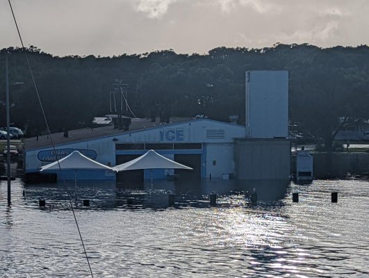
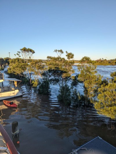
But not just Lismore--this was the entire northern rivers NSW region. Mullumbimby, Brunswick Heads, Coraki, and all the smaller towns and villages and individual farms were also under water at the same time, meaning they were all pretty much on their own in terms of response and rescue instead of the normal regional response on one flooded town. Downriver, Woodburn was simply obliterated by the vast flood sweeping down from Lismore and across the entire floodplain.
As families were pulled out by the SES (state emergency services) and the private tinnie fleet, the only place they could go was Evans Head, itself under assault once the Richmond overflowed at Woodburn into the Evans River--they are normally kept separate by a small weir on a linking canal.
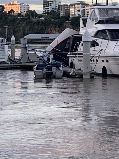
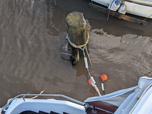
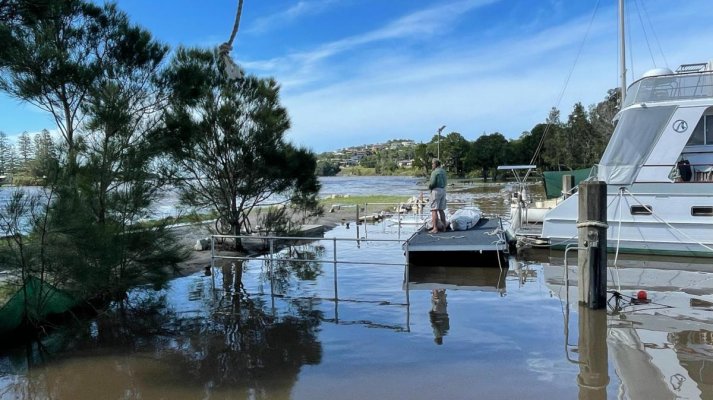
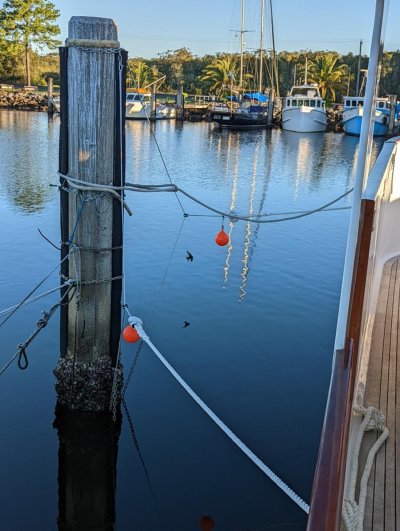
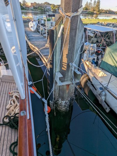
At Evans, we are moored in the Evans Head Fishing Cooperative embayment built into the south side of the river about 40 years ago. A rockwall separates the deep channel from the moorings with a single narrow entrance at the east end where the coop buildings are located. The normal tidal range is about 1.8 meters. It is a classic fishing coop mooring, not a marina. Each mooring has 4 hexagonal concrete pilings, 2 inner and 2 outer pilings. The inner pilings are served by a narrow wooden jetty and have a rubber rub rail to grind against the trawlers (only one is left out of fleet of 50 or more in the past).
Evans Coop on Gmaps
Evans Head Fishermens Cooperative · 12-32 Ocean Dr, Evans Head NSW 2473, Australia
To moor without slack tides due to the tidal range and fixed mooring points on the pilings, we installed a rig of chain in recycled firehose at the top and bottom of the piling; and a vertical dyneema line with friction ring attached to a strop to slide up and down with the vessel on the rising and falling tides. With four point mooring using both sides of the mooring, it was possible to create a stable 4 point mooring standing off the pilings. We have already experienced some serious storms including a 40-50 knot southerly the day that we arrived in Evans Head and we are confident the web of 24 mm 3 strand nylon mooring lines and dyneema rig is trustworthy.
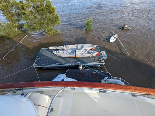
However, access is difficult and dangerous from the jetty the stern stairwell and swim platform. So a week before the flood, we installed a 5.7 meter custom catamaran pontoon to which we plan to attach to a hinged gangway that in turn will attach to a hinge on a concrete block on the rockwall.
Party BBQ Pontoon Boats used as Work Barge, work platform, Docks, Moving Craft, Transport Barge, Croc Boat, Cattle Transport and Fishing!
The week before the flood, we poured the concrete and were planning to install the gangway about now after it cured.
However, the flood had other ideas.
On the first peak flood Sunday Feb 27th evening, we watched apprehensively as the level reached the same level as a storm event about a month early atop a King tide that saw the jetty submerged. Then it kept on rising. That night the high tide it simply stayed high as the river overrun overwhelmed the ocean water. As the flood started to surge down the Richmond and overflowed into Evans, the next night high tide saw the flood waters submerge the rockwall entirely until it was about a meter above the road. Up to that point, I had "slider" room on the dyneema lines, but the port side was setup closer to the pilings than starboard, and the lines had to be eased as the boat rose. Through the night, the raging torrent sluiced across the rockwall onto the stern of Aquabelle and the pontoon (at least the concrete was curing quickly faster under water than it would in the air--provided it wasn't washed away). I was concerned mostly about a large tree trunk spearing across the rockwall; and about the poor mooring lines of the 20 tonne aluminum motor vessel moored in the next mooring to the west--if it had come adrift it would have rotated onto us and all bets were off. We had "Minniebelle" the inflatable rigged and suspended on the port side ready to bale with spotlight and life jackets in case the flood suddenly rose another meter or two and it became untenable.
As dawn broke, the full scale of the flood became visible. It was frankly terrifying. The river was a rapids with large standing waves curving over the surface and running at 10-15 knots. Many trees went past out to sea and were washed up on the surf beach or further out to become deadhead hazards to passing vessels. By now, we were completely an island as the river on the lower south side had encircled lowlands to create a separate flow from the backed up shallow estuary to the west to the south and then back to the river right through the coop facility. As the waters rose on Sunday and Monday, the south side of the moorings became, well, a waterfall, and then the water kept on rising. Many boats were pinned down by short lines and a few rub rails were catching on top of the concrete pilings. But no-one sank. And inside the embayment, there actually wasn't much current so provided you could absorb the sluicing top meter off the main river over the breakwater, it was simply a matter of sitting tight and praying for the rain to stop.
Now, a week later, we are still all shocked. There are a couple of hundred of Woodburn families in evacuation centers in Evans with nowhere to go--their town is essentially obliterated.
The big question being asked by everyone, at all levels, is what to do differently?
We bought the farmlet at Booerie Creek precisely because the house was 6 meters above the peak 1974 flood. But 1974 is no guide now; who knows what more intense and frequent storms will bring. The 6 meters safety margin is now down to 3.5 meters. Should we sell and move higher?
We moved Aquabelle to Evans Head to be in a safe mooring close to Booerie Creek, easy day driving distance. Should we move to the south side of the coop and away from the rockwall. Should we simply admit that staying on a boat at Evans is now of uncertain safety and we need to move to Yamba (too far from the farm) to the marina which is at risk but modern design and facilities (albeit Yamba itself was cut off by the floods last week until yesterday!).
These are the kind of micro-decisions that everyone is making in the northern rivers NSW. And we were the lucky ones--dry, relatively safe, did not lose much of anything, just stress and shock. My five year old grand daughters state school was flood-proof built; but was devastated. So suddenly no school; and the next state school within reach, also gone. So it goes multiplied by tens of thousands.
At the macro-level, simply rebuilding Lismore in the flood zone is not financially feasible. At least half or more of the businesses will not come back. The rest will be hobbled by no flood cover. It's time for the state to make some basic decisions about planned retreat, and to locate and build the new CBD infrastructure. This cuts against the free market grain of the state and federal governments; but I predict that public pressure will be so strong that they will have to adjust, and figure out an equitable way to distribute the cost of the relocation and construction of a new CBD that doesn't simply impose all the costs on those who lost all. The floods also amplify the already super-critical shortage of affordable housing as tens of thousands of families need immediate and on-going places to stay.
This flood will also have a political effect at the federal level, with elections looming. The Australian PM has been in covid-induced isolation during these floods, just as he was MIA during the 2019 firestorms on holiday in Hawaii. The only visible federal response has been deployment (slowly) of Australian Defense Force personnel to assist police and SES. Except for a few denialists, no-one can argue credibly that we do not have a climate problem in Australia which, as the driest continent, is highly sensitive to climate variability in the short term, and cumulative climate change in the long-term. More Australians now live in fire and flood zones than ever before, and are more vulnerable than ever before to climate impacts. How Australia mitigates and adapts is now on the political agenda and those who fail to respond will be swept aside over the coming months and years.
Meanwhile, we are the midst of a global pandemic that is complicating emergency operations and evacuations; we went through a tsunami a month ago; Putin is making veiled nuclear war threats in the Ukraine conflict; and there are still two months of wet season here in the northern rivers. Last night we had a powerful storm squall come through from the northwest with cyclonic winds, lightning and rain--only this time, it was short and sharp.
What else could possibly go wrong?
You can see videos on Evans Head Information Exchange Facebook page (I try to avoid Facebook but in this instance, the page was where all the decentralized, ad hoc and improvised coordination happened to mobilize tinnies, food, housing, medical supplies)
Log into Facebook
my update vids--search for:
"Evans Riverfront Update--Flood Receding Very Slowly"
"Riverfront rockwall high tide update"
"Evans River Max Flood 0915 from Coop Rockwall"
There is also a great drone video (starring Aquabelle)
"Evans head, much love to everyone and hope your all well and safe."
If you would like to help Lismore respond, please visit the Lismore flood page where you can donate (and also see all the prosaic details about sewage systems, asbestos removal etc.).
Disaster Recovery Updates - 2022
I have attached some photos of the max floods including the mooring rig (designed by Pegasus' rigger in CA Guy Stevens (my Alden ketch is moored in Berkeley) and installed by Scooter, Yamba-based rigger) that may be of interest to Ozzies puzzled like me by how to deal with concrete pilings and big tidal ranges. Many have improvised similar systems before; this was just an attempt to update to modern materials and so far, it has worked flawlessly.
Others also rode out the floods dodging bullets such as Ocean Alexander Mark 1 Isoquent. Brian may report on Brisbane river floods and the projectiles that hit his marina sinking boats nearby.
 

Attachments

  • PXL_20220227_064832973.jpg
    PXL_20220227_064832973.jpg
    193.3 KB · Views: 18
  • PXL_20220228_210039054.jpg
    PXL_20220228_210039054.jpg
    127.8 KB · Views: 14
  • PXL_20220228_205752561.jpg
    PXL_20220228_205752561.jpg
    160 KB · Views: 14
  • PXL_20220228_205711296.jpg
    PXL_20220228_205711296.jpg
    183.7 KB · Views: 14
  • PXL_20220301_085230985.jpg
    PXL_20220301_085230985.jpg
    80.5 KB · Views: 15
  • PXL_20220301_200706687.jpg
    PXL_20220301_200706687.jpg
    168.3 KB · Views: 13
  • Peter on Pontoon Mar3-2022.jpg
    Peter on Pontoon Mar3-2022.jpg
    148.7 KB · Views: 16
  • PXL_20~3.jpg
    PXL_20~3.jpg
    157.8 KB · Views: 13
  • PXL_20~2.jpg
    PXL_20~2.jpg
    161.6 KB · Views: 13
  • PXL_20~4.jpg
    PXL_20~4.jpg
    185.4 KB · Views: 11
Last edited:
Wow, Pete, that was some post. Sorry to hear of your travails, but sadly scenes like that have been the order of the day locally as well for so long, one tends to get inured to it a bit. The shock factor has settled down to a kind of numbness. But yes, Lismore and surroundings is just not a good place to be right now. :flowers:

Interesting you now own Aquabelle. I exchanged PMs with her former owner on several occasions when he needed information when passing through my neck of the woods. Brian on Insequent also often advised him. :)

But, please explain how it is you cite a US locality in your profile, when you are presently holed out just 300k south of us here in Queensland, and own a small farm there as well..? :confused:
 
To all TFers affected,especially Kit and Peter,best thoughts.

Sydney and the Hawkesbury are getting absolutely hammered periodically, and just rained on inbetween. I`m hoping the Hawkesbury doesn`t rise to float my marina off its pylons, the owners assure me it won`t.
The centre of the low is expected to move east and contract offshore as winds increase to severe up to 100km/h+ tonight and tomorrow, mainly coastal.
 
Peter B, I am a dual national. I direct https://www.nautilus.org/ in CA which works on complex, interrelated global problems; and also Pegasus Project https://www.facebook.com/Pegasus-Project-Berkeley-Marina-196511148851/ which is supported by my Alden 51 foot ketch which I have owned since 1994.
My Nautilus work took me to Mongolia in Dec 2019 for a meeting with North Koreans in Ulan Bator. I then went to Brisbane and planned to return to Bay Area in March when covid hit. With family here to support in the lockdown and high cost and uncertainty of trans-Pac flights, plus Oz government restriction on travel, not to mention the Delta and Omicron waves, I stayed. Here's my covid retreat-shed. It's made of recycled materials, hardwood inside, rustic, actually quite nice inside and lovely verandah. But after a year and a half in Lismore heat and cramped existence, I had enough and was lucky to find Aquabelle after two covid-border blocked contracts to buy an Angel 56, one in Hobart, one on Gold Coast.
For how long is anyone's guess. There's so much uncertainty in the world it seems best to focus on what's important here and now. I have a great crew and captain to run Pegasus with me away and to resume community voyaging. I never thought I'd go over to the dark side, but here I am. And I am lucky in that my work is virtual and can be done from anywhere with Internet. Speaking of which, we put an Ubiquity antenna on the roof of the coop opposite our mooring to bridge the NBN broadband to Aquabelle and are waiting to find out if the flood took out the electrical circuit that supports it. The hard ware was mounted high enough to be not inundated.
 

Attachments

  • The Shed cropped.jpg
    The Shed cropped.jpg
    170.5 KB · Views: 9
Thanks for that detailed explanation, Peter, from another Peter. I hope things start to improve down there. Things are fining up here - sunny outside and it tipped 36ºC there today at one stage.

Now the real challenge is going to be how to deal with all the damage, to property, and to the people, both physical and mental...
 
Back
Top Bottom