Weather Accuracy??

The friendliest place on the web for anyone who enjoys boating.
If you have answers, please help by responding to the unanswered posts.

Shrew

Guru
Site Team
Joined
Jan 9, 2014
Messages
4,175
Location
USA
Vessel Name
N/A
Vessel Make
1999 Mainship 350 Trawler
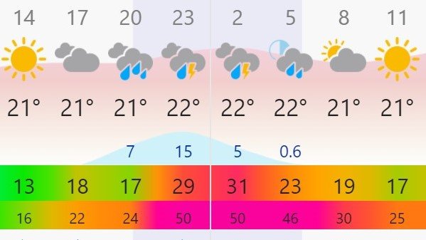
I've been anchored in my current location for about 2 1/2 weeks. I tend to use the "Windy" app. The screenshot at the bottom of the post is what Windy is showing for Thursday into Friday.

However here are other reports:

The Weather Channel: Thursday (night): Wind SSW 20
Friday: W 16

Accuweather: Thursday: Wind S 10-16
Friday: Wind W 15-18

What should I make of the Windy reports?

What tools are other folks using??


I can move on Thursday morning. We have a protected slip 3 hours away. On the other hand I have a good spot in a typically crowded anchorage.

Cue 'The Clash' "Should I Stay or Should I Go?"
 

Attachments

  • Windy (2).jpg
    Windy (2).jpg
    62.3 KB · Views: 54
Last edited:
I can't speak for your part of the world, but out forecasts from NOAA when compared to Windy are all over the place. Depending on how far out you look for a forecast, Windy gives you 4 possible models. I tend to look at the all the models and see if they are generally agreeing and then compare that to NOAA. The problem with all of these forecasts is they don't take into account local terrain. While NOAA will appear to give you a forecast for a specific location, in marine forecasts they do it by zones which can be pretty big (70-80 miles wide or tall) and sometimes include a strait with an 80 degree dogleg in Alaska. After 8 years in Southeast Alaska, I temper the forecast with local knowledge and looking at current observations. Even the observations are not to be completely trusted as some the sites are blocked from the actual wind on certain azimuths. NOAA doesn't talk about that.

Tom
 
On the East Coast, weather people watch the storms travel across America for days.
On the West Coast, especially Alaska, they open their window to see what's happening.
I do my own forecasting. I use NOAA for pictures and windy for an idea of the wind.
When I was a fisherman, many wanted to tie the forecasters to their bow so they could compare their forecast to reality.
 
For many folks the local TV view is very specific on what one can expect for the day.
 
I never liked the windy forecasts. I thought the weather channel was better.
I'd STAY anchored at Block.;)
 
When I was a fisherman, many wanted to tie the forecasters to their bow so they could compare their forecast to reality.

Now that's funny. :thumb:
We have the same problem with predicted wave height, near shore.
 
When we are cruising, we take the Windy, Weather Underground, and National Weather Service forecasts, and kind of average them together for the best guess on what's about to actually happen.

No one can really reliably forecast past about three days, in our experience cruising, where we were studying the weather and forecasting on a daily basis.

And, of course, like everyone here, we have experienced forecasts that were laughably wrong. I think they often give a pessimistically slanted view, knowing that not many people are going to complain if the weather is a little better than were told it would be.

But, from our sailing days, we recall many days of fighting winds that were 20 knots higher than predicted and the direction off by 180 degrees!
 
Last edited:
Like FF, I mostly rely on local TV forecasts. Unfortunately, they don't often include wind predictions and even if they did, wind on open water can be different than wind inland.

On the Internet, five "weather sources" will predict five different weather scenarios. Only if a storm is coming are they likely to be similar. And weather sources tend to predict that things will be worse than they actually are, perhaps from fear of being sued.

In most cases, I wake up, look out the window, and decide what I'm going to do that day.
 
Check the Windy app units for wind speed. Guessing those aren’t knots?

I use Windy, NOAA and Passageweather. Passageweather is showing 20-25 in that time period with both the GFS and NAM models.
 
Last edited:
I use and like Windy for wind while on the water and to see the big picture. As I recall you can set/change units somewhere in the settings.
I look at several model fcsts and recommend using the worst case to be safe... some may be tempted to look for the best fcst for their needs but that can be dangerous.
Many fcsts are not totally wrong but things happen sooner or later than a given fcst.
With violent Wx it frequently is very spotty and some areas get hit bad and others barely notice. If you play those odds its like trying to tip-toe through a mine field.

I'll attach an article I wrote for our boating newsletter re Wx Apps icluding some discussion re Windy
 

Attachments

  • Wx Apps 2.pdf
    568.2 KB · Views: 31
Last edited:
I would only cross the Gulf of Mexico in my Grand Banks in the calmest conditions, and nowadays, I do NOT enjoy bouncing around during the occasional several-hour fishing trips out to about 20 miles or less from shore; so, wave and wind predictions to a fine degree of accuracy are critical. I pick the possible day to go about five days ahead by checking with the local TV forecaster to make sure the summer thunderstorm outlook is minimal for the timeframe. Then I look at windfinder.com for winds and stormsurf.com for seas, and I keep an eye on these two as the day approaches to see a consistent pattern. Then, one hour before departure for the hour-plus run to St Andrew Bay pass, I look at several webcams on Panama City Beach. If the water is lapping onto the sand, ok, otherwise, it may end up being a bay day. I was not overly impressed with windy last year on a delivery from Norfolk to the Big Bend, but it was not absolutely terrible either. I guess I like what I am used to which mostly works for me.
 
PredictWind does factor in local terrain in their forecasts. You can compare 7 different forecast models. For a modest fee you get a 1 km model that seems more accurate locally when terrain is a factor (PNW). You can judge the accuracy by comparing 4 or 5 different models - if they disagree, then prepare for anything, if they agree then it is probably going to happen.
 
I use and like Windy for wind while on the water and to see the big picture. As I recall you can set/change units somewhere in the settings.
I look at several model fcsts and recommend using the worst case to be safe... some may be tempted to look for the best fcst for their needs but that can be dangerous.
Many fcsts are not totally wrong but things happen sooner or later than a given fcst.
With violent Wx it frequently is very spotty and some areas get hit bad and others barely notice. If you play those odds its like trying to tip-toe through a mine field.

I'll attach an article I wrote for our boating newsletter re Wx Apps icluding some discussion re Windy

We use multiple models and that is one thing we like about Windy. You have ECMWF, GFS, and ICON all available in one application. They will differ, sometimes significantly and that's the way it is with forecasting. 24 hour windows very accurate. 72 hours, good and consistent. As you move out to a week, you get variations both in location and intensity of systems.

One thing I like is that you see the greater picture and see what might lead to change. This is especially true looking at an area like the Gulf of Mexico. Right now, they all have similar patterns but different timing. You may find yourself waiting for a system to pass through as the timing of that is different, but you see nothing behind it once it does.

We also look at the worst. We've found ourselves on long crossings also looking at ways around systems. We recently had a long crossing to make in Europe and a system off the coast. Delaying didn't do much for us, but changing our path a bit more to the east avoided the bad sea conditions.

I know many focus on winds. We focus more on sea conditions. Now typically the two go together. One thing we like about Windy is the ability to separate wind waves and swell waves, even to multiple swells.

As noted, Windy is a good big picture resource and then you can use any weather software tied to your chart systems. My main recommendation though is to use more than one forecast, however you obtain it. If there is a consensus, then use it. If not, use the worst.
 
Check the Windy app units for wind speed. Guessing those aren’t knots?

I use Windy, NOAA and Passageweather. Passageweather is showing 20-25 in that time period with both the GFS and NAM models.

I keep wind speed in MPH since the is the default for US based weather from almost all other sources. I only use NM for distances and travel speed, since most charts are in NM rather than statute miles.

I did find on Windy that there are actually several data model sources and my view is defaulted to only one of them. The discrepancy with the other sources is they are giving Avg. sustained wind speed for a large portion of the day, not sustained and gusts.

I also see that there is a very tight low pressure system currently over eastern Lake Erie. That is what is barreling down on us.
 
We use multiple models and that is one thing we like about Windy. You have ECMWF, GFS, and ICON all available in one application. They will differ, sometimes significantly and that's the way it is with forecasting. 24 hour windows very accurate. 72 hours, good and consistent. As you move out to a week, you get variations both in location and intensity of systems.

One thing I like is that you see the greater picture and see what might lead to change. This is especially true looking at an area like the Gulf of Mexico. Right now, they all have similar patterns but different timing. You may find yourself waiting for a system to pass through as the timing of that is different, but you see nothing behind it once it does.

We also look at the worst. We've found ourselves on long crossings also looking at ways around systems. We recently had a long crossing to make in Europe and a system off the coast. Delaying didn't do much for us, but changing our path a bit more to the east avoided the bad sea conditions.

I know many focus on winds. We focus more on sea conditions. Now typically the two go together. One thing we like about Windy is the ability to separate wind waves and swell waves, even to multiple swells.

As noted, Windy is a good big picture resource and then you can use any weather software tied to your chart systems. My main recommendation though is to use more than one forecast, however you obtain it. If there is a consensus, then use it. If not, use the worst.

Many thanks, this is very helpful. I recently found the option to toggle the weather models on Windy.

Curious what other apps or sources you keep in your back pocket?
 
We use multiple local weather sources, but the first "go-to" is always Windy.
 
We use multiple local weather sources, but the first "go-to" is always Windy.

And for those of you not familiar, the common measurement of wind speed in Scott's area is m/s. For convenience, I mentally convert by doubling so 20 m/s to 40 knots, although it's actually 38.8.

And to personally thank those like Scott and others who have provided us all sorts of useful information for our summer cruise.
 
We also have a NavTex display near the helm, which is on all the time. Urgent weather and traffic alerts come over this quite reliably...in many languages.
 
We also have a NavTex display near the helm, which is on all the time. Urgent weather and traffic alerts come over this quite reliably...in many languages.

Yes, one of our group was listening to the yellow warnings of wind in French earlier before translating to the less fluent among us. Today, Friday, has 24 mph winds and 32 mph gusts forecast, but all we need to do is make it into river and calm. 1' seas going to 6' during the day. We're getting a very early start to escape.
 
I think the West Coast local weather forecasters just repeat NOAA. And NOAA is like any government agency, full of comfortable people, bored with their job. Except Alaska where local stations don't want a bunch of irate mariners showing up at their studios.
I've been off Northern California in my 55' commercial fishing boat in the forecast light winds, 5-15kts, 3-5' seas and swells where it was breaking over my cabin. And that happened several times a season. Yet the marine weather channel droned on with the same bad forecast. If they just opened a window, they would have a better forecast. Oregon and Washington are a little better.
 
We had some pretty severe storms come through here in the last few days so I watched, listened and compared several weather reporting stations. (Mostly apps but also NOA)

One app really covered their butts, forcasting 1% chance of rain hourly for an entire evening.

I like the NOA "local observations.

pete
 
We've found Windfinder to be the most accurate regarding long range (1 week +) forecasts. It also shows us the sea conditions which we find quite useful. Windfinder ,and as FF mentioned, turning the TV on to a local station early in the morning for an accurate prediction of the weather in the area are what we do while cruising. Before the days of internet and cellular phones onboard, it was just the local TV weather in the morning and it was fine.
 
I think the West Coast local weather forecasters just repeat NOAA. And NOAA is like any government agency, full of comfortable people, bored with their job. Except Alaska where local stations don't want a bunch of irate mariners showing up at their studios.
I've been off Northern California in my 55' commercial fishing boat in the forecast light winds, 5-15kts, 3-5' seas and swells where it was breaking over my cabin. And that happened several times a season. Yet the marine weather channel droned on with the same bad forecast. If they just opened a window, they would have a better forecast. Oregon and Washington are a little better.

It's no better on the East coast. I can't tell you how many time the marine weather forecast is "seas 1 foot or less" and I've got waves of 4' or more.
 
Very often wind and waves vary greatly from local phenomena.


As a boater...I often was intrigued while flying the coast low level, how from one small section of coast (say 5-20 miles) would have completely different wave heights, even directions (to a smaller degree). One area would seem fairly calm with the next having significant whitecaps.


Usually the apps I have used (quite a few now) never really show the localized effects I have witnessed. Some are easy to figure out such as wind against tide, shoaling, narrowing of land mass wind acceleration, etc...but some not so easy to explain as they are unseen wind patterns within an area of forecast weather.
 
Last edited:
Very often wind and waves vary greatly from local phenomena.


As a boater...I often was intrigued while flying the coast low level, how from one small section of coast (say 5-20 miles) would have completely different wave heights, even directions (to a smaller degree). One area would seem fairly calm with the next having significant whitecaps.


Usually the apps I have used (quite a few now) never really show the localized effects I have witnessed. Some are easy to figure out such as wind against tide, shoaling, narrowing of land mass wind acceleration, etc...but some not so easy to explain as they are unseen wind patterns within an area of forecast weather.


This is exactly it. Some areas are more prone to screwy wind effects, and they're not always consistent enough to know what to expect based on the general forecast.
 
This is exactly it. Some areas are more prone to screwy wind effects, and they're not always consistent enough to know what to expect based on the general forecast.

I'm not so quick to give them a pass. I'm not talking about very localized anomalies, but marine weather is supposed to get data from buoys and at times huge bodies of water are much worse than forecasted.
 
I'm not so quick to give them a pass. I'm not talking about very localized anomalies, but marine weather is supposed to get data from buoys and at times huge bodies of water are much worse than forecasted.


I usually look at both the forecast and the buoy data. It seems like the marine forecasts typically report what they're expecting over the next few hours, but with only a small influence from what's actually out there. It sucks, but it's manageable if you look at enough sources of data.
 

Latest posts

Back
Top Bottom